A Beaufort County South Carolina Map makes more sense when the county is treated as a coastal landscape rather than a simple block of land. Beaufort County spreads across islands, peninsulas, broad river mouths, tidal creeks, and mainland corridors in South Carolina’s Lowcountry. The maps on this page show the Beaufort–Port Royal area, the Bluffton–Hilton Head Island area, the roads that tie those places together, and the extensive water network between them. After reviewing the maps, you can download the matching high-resolution JPG files in one ZIP archive.
The county outline immediately shows why straight-line proximity can be misleading here. Beaufort and Port Royal sit in the northeastern half of the county, Bluffton occupies the southwestern mainland, and Hilton Head Island lies farther toward the Atlantic. Yemassee and Sheldon provide northern reference points, while Daufuskie Island marks the county’s southern island edge. Between those places are wide waterways and branching tidal channels that interrupt what would otherwise look like short overland connections.
That geography also explains why the three supplied maps answer different practical questions. The county map is best for roads, places, and the boundary. The city-connections map simplifies the settlement pattern and compares direct distances from Hilton Head Island. The terrain-and-water map removes much of the road detail so the Broad River, Coosaw River, sounds, creeks, and Atlantic shoreline can be seen without distraction.
Table of Contents
A county shaped by islands, river mouths, and tidal edges
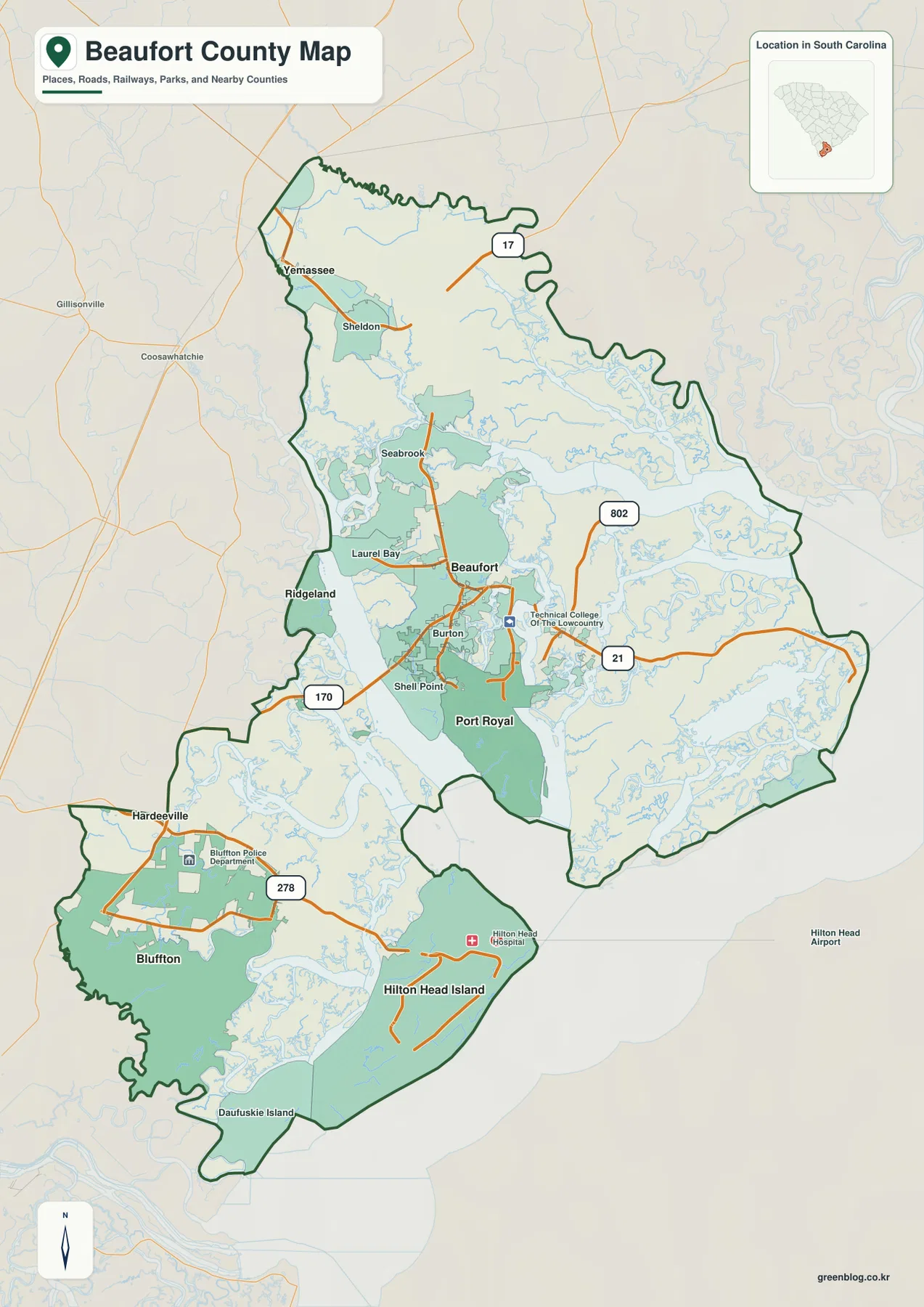
The county overview has an outline that is very different from a typical inland county. Its northern edge is relatively continuous, but the center and south are cut by large bodies of water and narrow coastal inlets. The Beaufort–Port Royal portion forms one major cluster, while Bluffton and Hilton Head Island form another. Daufuskie Island appears at the far southern end, reinforcing the point that the county is a collection of connected coastal landforms rather than one compact piece of mainland.
Several labeled communities help anchor the map. From north to south, the map includes Yemassee and Sheldon, then Seabrook and Laurel Bay, followed by Beaufort, Burton, Shell Point, and Port Royal. Bluffton and Hilton Head Island dominate the southwestern and ocean-facing section. Ridgeland and Hardeeville appear outside the county as nearby reference places, which is useful when reading the western edge without confusing those places with Beaufort County communities.
The road pattern is selective but informative. U.S. 17 is labeled in the northern part of the county. Route 21 is a major reference around Beaufort and continues toward the coast, while 802 provides another east-west connection in the Beaufort area. Route 170 helps explain the link between the Beaufort side and the southwestern side, and U.S. 278 is the clearest route reference around Bluffton and Hilton Head Island. Because the coastline is so fragmented, these routes are easier to understand when viewed together with the water map later on the page.
The Hilton Head–Bluffton–Beaufort settlement chain
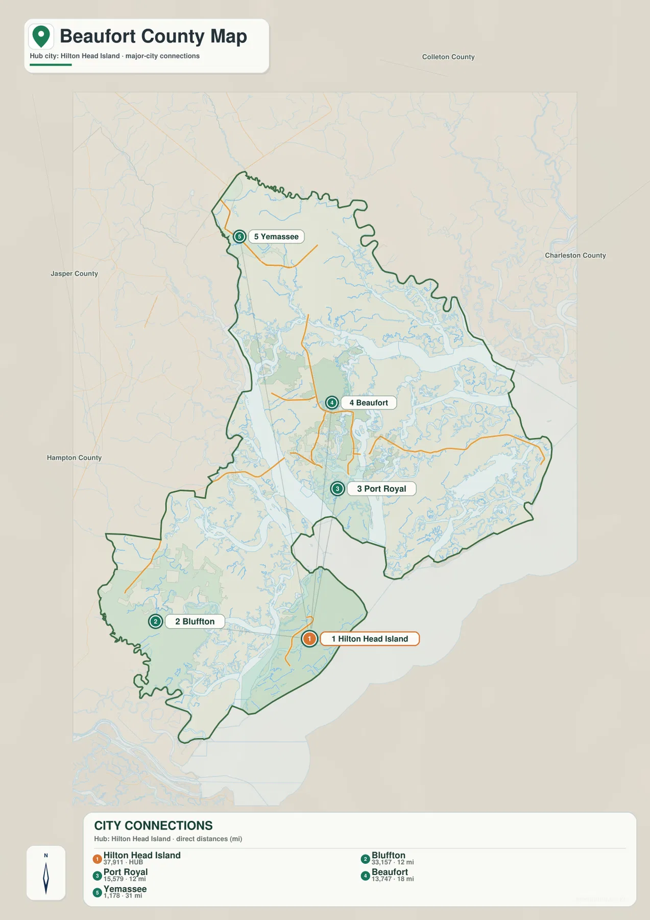
The city-connections map uses Hilton Head Island as the hub and reduces the county to five major reference places. Bluffton and Port Royal are each shown about 12 miles from Hilton Head Island, Beaufort about 18 miles away, and Yemassee about 31 miles away. These are explicitly labeled as direct distances, not driving distances. That distinction matters in Beaufort County because a route may have to cross a bridge, follow a causeway, or detour around a broad tidal river.
The ordering reveals two strong settlement clusters. Hilton Head Island and Bluffton form the southern cluster, with Bluffton serving as the mainland counterpart to the island. Beaufort and Port Royal form a second cluster farther northeast. Yemassee sits well to the north and acts as a useful inland reference point. The map therefore gives a quick sense of where the county’s principal populated places sit relative to one another before the more complicated road and water details are added back in.
Nearby county labels around the edges—Jasper County, Hampton County, Colleton County, and Charleston County—also help orient the frame. They are best treated as directional context rather than as a claim that every labeled county shares the same type of land boundary with Beaufort County. For the purpose of this map, the main value is seeing how the Beaufort County places are arranged within the wider Lowcountry.
Broad River, Coosaw River, and the Atlantic-facing water network
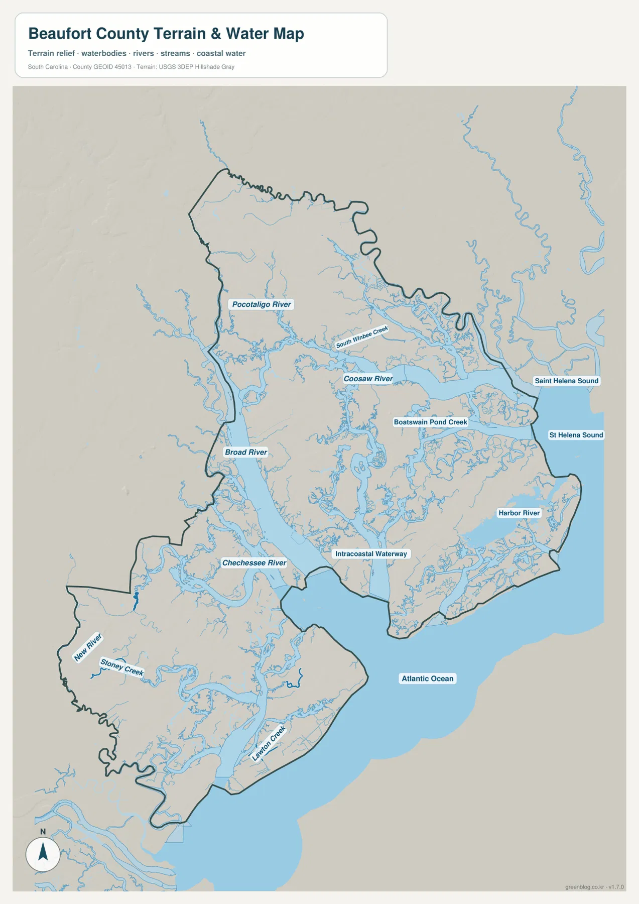
The terrain-and-water map provides the strongest explanation for the county’s unusual outline. Broad River cuts a large channel through the central-western part of the county, while Coosaw River runs across the northeastern section. Pocotaligo River appears in the northwest, and Chechessee River forms another important water reference in the southwest. On the ocean side, Saint Helena Sound and St Helena Sound open toward the Atlantic Ocean, so the eastern edge is more water boundary than simple coastline.
Smaller names make the network even more detailed. South Wimbee Creek, Boatswain Pond Creek, Harbor River, New River, Stoney Creek, and Lawton Creek are labeled, and the Intracoastal Waterway appears through the southern-central part of the county. These features show why there are so many narrow shorelines and branching channels around Beaufort, Port Royal, Bluffton, and Hilton Head Island. The map is not a navigation chart or a flood-risk map, but it is a useful geographic reference for understanding why roads and settlements occupy the land corridors they do.
Comparing this map with the county overview is especially helpful around Beaufort and Port Royal. The settlement cluster sits among several large water bodies and smaller tidal channels. Farther south, Hilton Head Island faces the Atlantic while interior waterways separate it from other parts of the county. Bluffton is on the mainland side but still surrounded by branching creeks and river channels. The result is a county where water is not simply at the edge; it is part of the internal structure.
Reading the road network without losing the coastline
A useful way to read the county map is to pair each major road with a nearby place. Route 21 is a strong Beaufort reference and continues through the central coastal area. Route 802 runs across the Beaufort side, while Route 170 helps connect the Beaufort area with the southwestern mainland. U.S. 278 is the clearest road label for Bluffton and the Hilton Head Island approach. In the north, U.S. 17 helps locate Yemassee and the inland edge of the county.
This approach makes the map easier to use because the county does not have a simple central crossroads. Instead, the transportation network follows bridges, higher land, and narrower gaps between waterways. The roads that appear on the map are therefore more than labels: they show where movement is possible across a landscape broken into islands and river-separated sections. When a road line bends or concentrates in one corridor, the water map often explains why.
It is also useful to distinguish internal and external reference places. Ridgeland and Hardeeville are visible near the western side but sit outside the Beaufort County boundary. Beaufort, Port Royal, Bluffton, Hilton Head Island, Yemassee, and the other labeled communities inside the dark boundary are the places that define the county map itself. That distinction becomes important when the map is used in a report, classroom activity, or regional comparison.
Choosing the right file for the question
Use the county overview when you need the broadest single-page reference. It combines the boundary, several communities, and the most important numbered roads, so it works well for locating Beaufort, Bluffton, and Hilton Head Island in relation to one another. It also preserves enough surrounding context to show where the county sits along the South Carolina coast.
The city-connections map is more useful when relative position is the main question. Its direct-distance labels quickly show that Bluffton and Port Royal are the closest of the selected places to Hilton Head Island, Beaufort is farther north, and Yemassee is farther still. For river and coast questions, the terrain-and-water map is the better choice because it names the major rivers, creeks, sounds, and the Atlantic-facing edge that shape the county.
- County overview: best for the boundary, communities, numbered roads, and general orientation.
- City-connections map: best for comparing Hilton Head Island with Bluffton, Port Royal, Beaufort, and Yemassee using direct miles.
- Terrain and water map: best for rivers, tidal creeks, sounds, the Intracoastal Waterway, and the Atlantic coast.
Frequently Asked Questions
How far is Beaufort from Hilton Head Island on the city-connections map?
The map labels Beaufort about 18 miles from Hilton Head Island. That number is a straight-line distance, not a driving distance. Roads have to follow bridges and land corridors around the county’s waterways, so the actual trip is longer.
Why does Beaufort County have such an irregular boundary?
Large rivers, tidal creeks, sounds, islands, and the Atlantic coast divide the county into many separate-looking land areas. Broad River and Coosaw River are especially prominent, while Saint Helena Sound and the Intracoastal Waterway add more coastal complexity.
Which map is best for comparing roads with waterways?
Start with the county overview to locate Routes 17, 21, 170, 278, and 802, then compare the same area on the terrain-and-water map. Using both makes it easier to see how roads concentrate on the available land between rivers, creeks, and sounds.
Map File Information
The ZIP contains the original high-resolution JPG versions of the same Beaufort County maps shown in this article.
- Included Files: county overview, city-connections map, terrain and water map
- Printable Size: 2572×3638 px each
- File Type: JPG
Related Maps
Sources
For county boundaries and administrative reference, see the South Carolina Association of Counties County Information and the U.S. Census Bureau TIGER/Line Shapefiles. Waterway data can be checked through USGS National Hydrography, while broader South Carolina terrain and geology references are available from the South Carolina Geological Survey.
Green Map creates custom-edited map images using open geographic data sources such as geoBoundaries, Natural Earth, OpenStreetMap, and government open data.
These maps are edited visual materials, not raw data files, and are provided for education, documents, presentations, and graphic reference.