DuPage County in northeastern Illinois is a densely settled county that becomes much easier to understand once Wheaton and Naperville are fixed as two different reference points. Wheaton is the county-seat center near the middle, while Naperville forms the largest city marker in the southwest. Elmhurst, Lombard, and Oak Brook extend the urban pattern eastward; Bartlett, West Chicago, and Carol Stream define the northwest; and Downers Grove with Woodridge fills much of the south. High-resolution JPG originals of the supplied maps are bundled in one ZIP download for printing, enlargement, lessons, and presentations.
The road network is only part of the county’s geography. West Branch DuPage River and East Branch DuPage River cut separate north-south low corridors through the urban landscape, while Des Plaines River reaches the southeastern edge. Small lakes and creeks break up the built-up areas, and the elevation map reveals a broad contrast between higher ground in the northwest and lower terrain in the east and southeast. That combination of dense suburbs and visible river valleys is the key to reading the maps together.
DuPage County government materials identify Wheaton as the county seat and place the county’s principal government offices there. The county was formed from Cook County in 1839. That background helps distinguish Wheaton from Naperville: Naperville is the largest marker on the supplied city graphic, but Wheaton remains the administrative reference.
Table of Contents
Wheaton connects the central cities while Naperville anchors the southwest
Wheaton sits close to the middle of the county overview, with Route 38 providing a clear east-west reference. Glen Ellyn and Lombard continue east of Wheaton, followed by Elmhurst and Oak Brook. To the north and northwest, Carol Stream, West Chicago, and Bartlett spread across a wider area, making the outer edge of the county feel less compact than the central corridor.
South of Wheaton, Lisle and Downers Grove appear before the map reaches Naperville and Woodridge. Route 83 runs near the eastern side, and the labels 290, 19, and 55 help identify the northeastern and southeastern approaches. With so many roads and municipalities, it is more useful to remember the Wheaton-Naperville relationship and the Elmhurst-Lombard side than to memorize every road line separately.
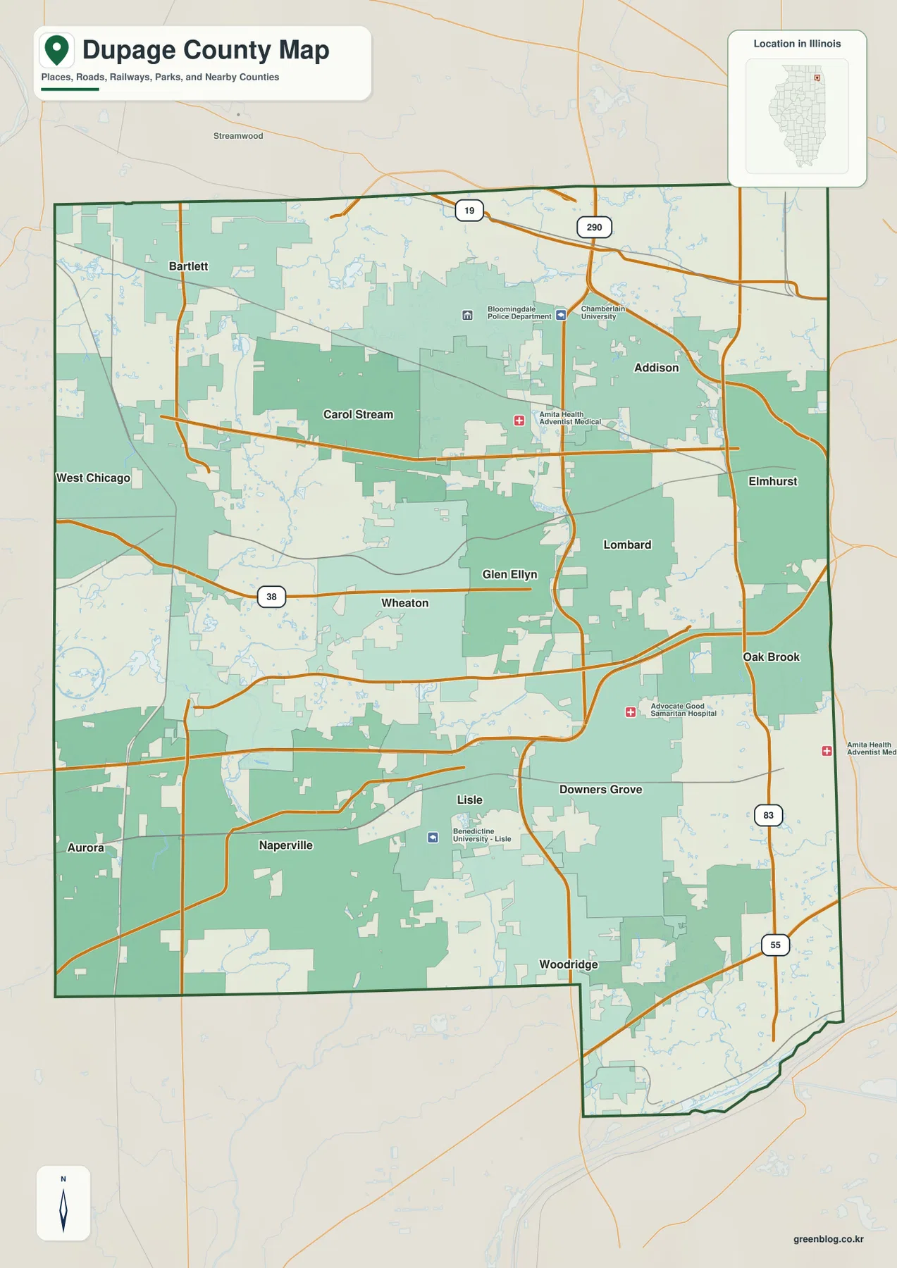
Several institutional labels show how continuous the built-up area is, including Northwestern Medicine, Advocate Good Samaritan Hospital, Benedictine University, and Chamberlain University. Wheaton and Glen Ellyn form a dense central area, and the Naperville-Lisle side is similarly well connected. Farther northwest and west, larger green areas and small water features appear more frequently. The overview therefore shows both a continuous suburban network and pockets where rivers, preserves, and open land interrupt it.
Wheaton is the county seat
DuPage County government identifies Wheaton as the county seat, and the county’s principal government address is also in Wheaton. Naperville is much larger on the city graphic, but it does not hold the county-seat role. Keeping those two functions separate makes the central-southwestern pattern easier to understand.
Naperville leads the city index while Wheaton holds the administrative role
The simplified city graphic gives Naperville the largest marker and Wheaton the second-largest. Downers Grove is third, Elmhurst fourth, Lombard fifth, and Bartlett sixth. The printed CITY INDEX lists 150,692 for Naperville, 53,557 for Wheaton, 50,054 for Downers Grove, 45,671 for Elmhurst, 43,619 for Lombard, and 40,501 for Bartlett.
No census year or statistical reference date appears next to those values, so this page does not present them as current population counts. Their placement is more dependable as geographic information. Naperville sits in the southwest, Wheaton near the center, Downers Grove toward the southeast, Elmhurst and Lombard on the eastern side, and Bartlett near the northwestern edge.
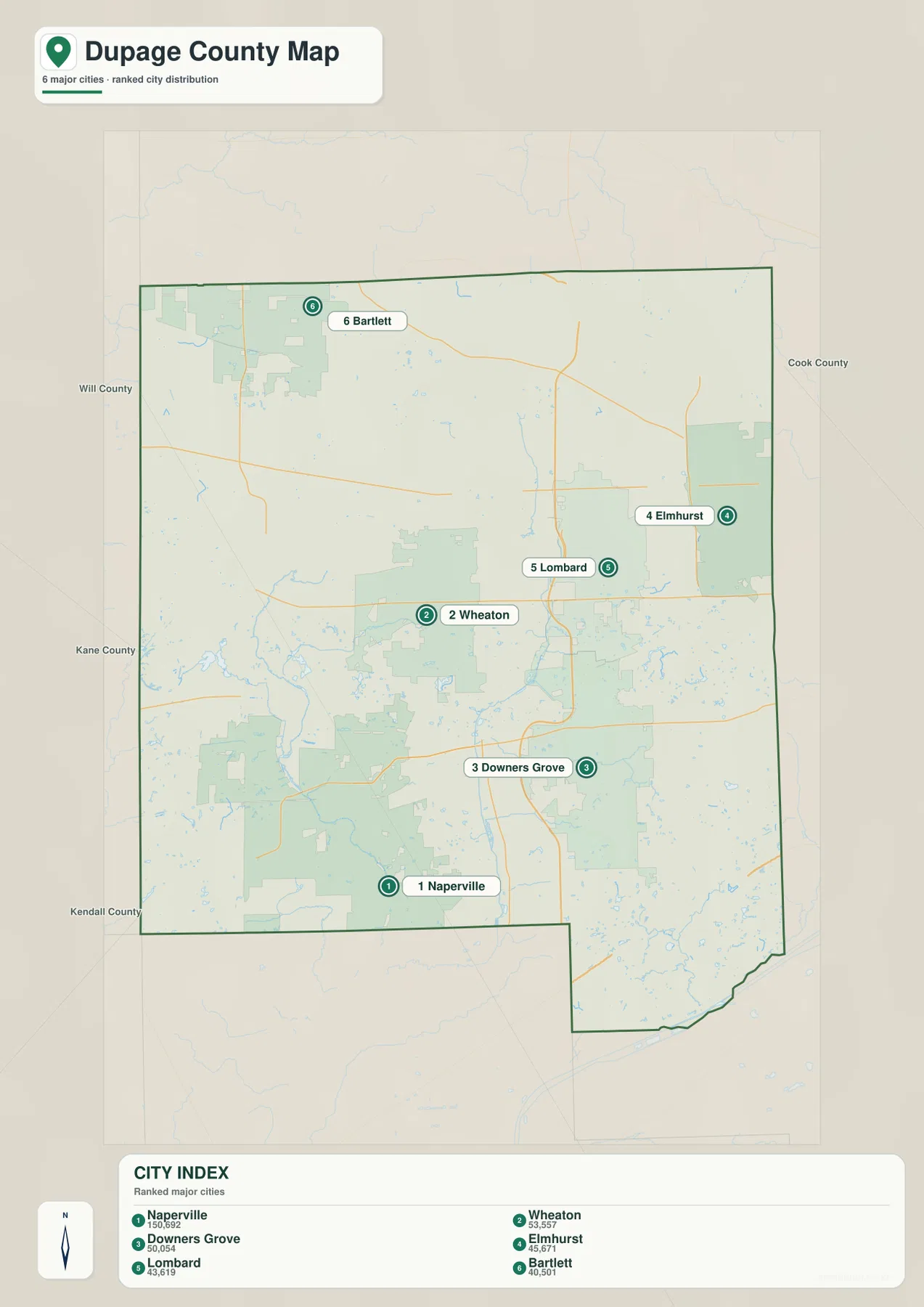
The city view is especially useful in DuPage County because the detailed overview can look crowded. Naperville provides the southwestern anchor, Wheaton the central administrative anchor, and the Elmhurst-Lombard pair the eastern urban reference. Bartlett stretches the simplified pattern to the northwest. Once those six positions are familiar, the road and water maps are much easier to follow.
The CITY INDEX is undated map data
Use a dated source such as the U.S. Census Bureau when current population is required. The supplied CITY INDEX does not identify its reference year, so this article uses the figures only to explain the ranking and relative marker sizes shown on the map.
The two DuPage River branches cut through the suburban county
West Branch DuPage River and East Branch DuPage River are the strongest interior water references on the terrain sheet. The West Branch runs through the western-central county, while the East Branch follows a separate corridor farther east. Their two valleys remain visible even where surrounding development is dense, creating long lower routes through the suburban landscape.
Brewster Creek, Norton Creek, and Kress Creek appear in the northwest. Spring Lake sits in the west-central area, while Mallard Lake is farther north. Herricks Lake and Rice Lake lie between the two DuPage River branches. Ginger Creek is labeled on the eastern side, and Des Plaines River forms the major water reference along the southeastern edge. The result is a county where small lakes and tributaries remain closely interwoven with the urban network.
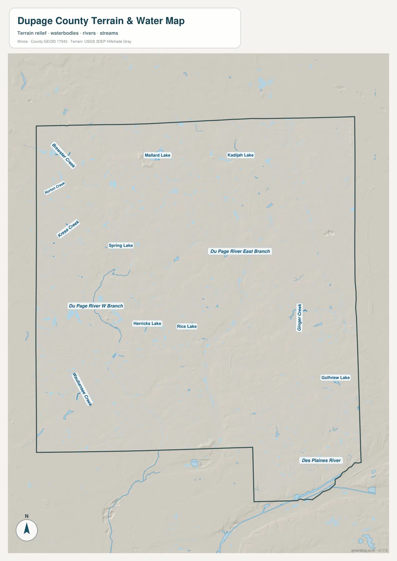
Forest Preserve District of DuPage County provides local examples of both branches. Its West Branch preserve contains more than two miles of West Branch DuPage River along with lakes, wetlands, meadow, wet prairie, and floodplain forest. The East Branch preserve is largely a wetland landscape along East Branch DuPage River with lakes and marshes. District fishing information also identifies both DuPage River branches, Salt Creek, and Des Plaines River as important county waters. These official descriptions match the supplied map’s pattern of urban areas broken by long river and wetland corridors.
The water map is not live flood or river-stage information
The terrain sheet is designed to show the positions of rivers, creeks, lakes, and surrounding relief. It does not report current DuPage or Des Plaines river stage, flood-hazard boundaries, water depth, fishing rules, or access conditions. For present-day safety or water use, check current DuPage County Stormwater, Forest Preserve District, USGS, or other responsible-agency information.
Higher northwest ground drops toward the eastern and southeastern lowlands
The elevation image shows the strongest high terrain in the northwestern part of DuPage County. Broad brown and orange areas occupy the northwest and western interior, while the colors become progressively greener toward the east and southeast. A long low corridor also cuts through the central county, aligning with one of the major river valleys. The contrast is much stronger than the road map suggests.
The map reports an actual countywide elevation range of about 155 to 292 meters and a mean near 222 meters. Its color legend uses narrower bands from roughly 200 to 244 meters, while the separate “Actual” line records the wider minimum and maximum of the dataset. Those endpoints describe DuPage County as a whole and should not be assigned directly to Naperville, Wheaton, Bartlett, Elmhurst, or any individual property.
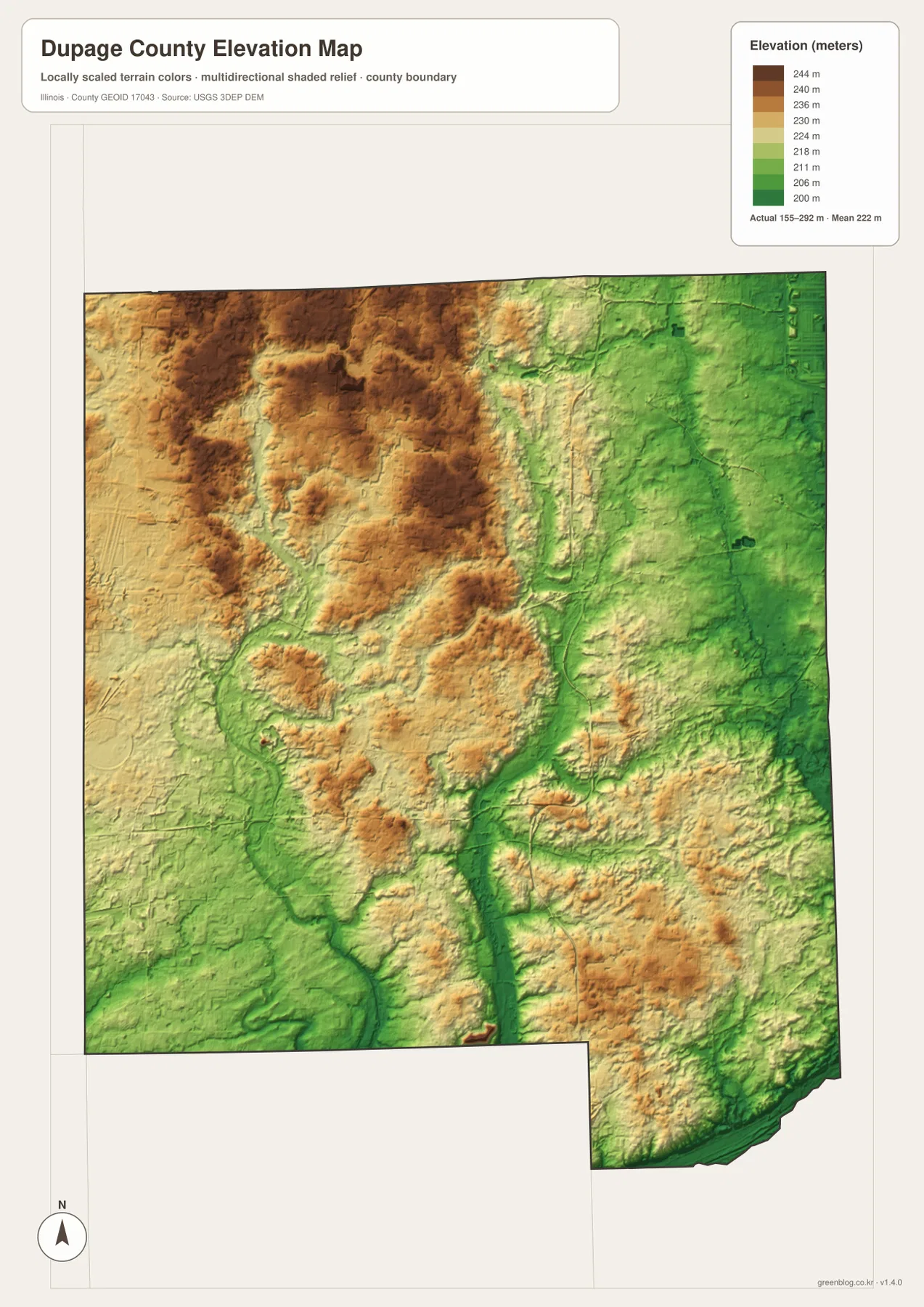
Comparing the elevation and water maps makes the low corridors easier to recognize. Both DuPage River branches follow green terrain below nearby uplands, and Des Plaines River occupies another low area near the southeastern edge. Smaller creeks cut into the higher northwest and west. Even in a strongly developed county, the underlying relationship between rivers and relief remains clearly visible once the road layer is removed.
155 to 292 meters is a countywide range
A building site, road grade, drainage plan, or parcel needs point-specific elevation data or a professional survey. The 155–292 meter range is most useful for comparing broad high and low areas across DuPage County, not for assigning an exact elevation to a named city or street address.
Keep Wheaton and Naperville fixed while switching to water and relief
A practical way to use the files is to keep Wheaton and Naperville fixed while changing the information layer. On the overview, add Downers Grove, Elmhurst, Lombard, and Bartlett around those two anchors. The city graphic then reduces the dense municipal pattern to six large reference points, making the county easier to remember.
Next, switch to the water map and separate West Branch DuPage River from East Branch DuPage River, then add Des Plaines River in the southeast. The elevation image completes the comparison by showing high northwest ground above the two river corridors and lower eastern terrain. Using the same landmarks across the files keeps cities, roads, waterways, and relief connected instead of treating each map as an isolated view.
Use current transportation sources for driving conditions, dated Census data for population, current agencies for river, flood, or preserve questions, and point-level elevation or survey data for site work. Within those limits, the DuPage County maps are useful for printed references, lessons, presentations, and advance geographic orientation.
Frequently Asked Questions
What is the county seat of DuPage County, Illinois?
Wheaton is the county seat. DuPage County government materials identify Wheaton in that role and place the county’s principal government offices there. Naperville is larger on the supplied city map, but it is not the county seat.
Does DuPage River have separate branches in the county?
Yes. The supplied terrain map labels West Branch DuPage River and East Branch DuPage River as separate north-south waterways. Forest Preserve District of DuPage County also maintains preserves along both branches and describes their wetlands, lakes, and floodplain habitats.
Does 155 to 292 meters give Naperville’s elevation?
No. The elevation image identifies 155–292 m as the actual range across the DuPage County dataset and gives a mean of about 222 m. Exact elevation for Naperville, Wheaton, or any specific property requires point-specific elevation or survey data.
Sources and Reference Material
The article uses the supplied DuPage County maps together with the official references below. For time-sensitive questions in DuPage County—such as road conditions, river stage, preserve rules, legal boundaries, or an exact elevation—use the latest material from the agency responsible for that subject.
- DuPage County Official Website – current county government and Wheaton administrative information
- Forest Preserve District – West Branch – West Branch DuPage River, lakes, wetlands, and floodplain habitat
- Forest Preserve District – East Branch – East Branch DuPage River, wetlands, lakes, and wildlife habitat
- USGS National Hydrography – river, stream, and lake reference data
- USGS 3D Elevation Program – elevation and terrain data
Map File Information
The ZIP file contains the high-resolution JPG originals for the DuPage County overview, city map, terrain-and-water map, and elevation map. Each portrait image measures 2,572 × 3,638 pixels, preserving municipality names, road numbers, smaller creek labels, and elevation colors more clearly when enlarged or printed.
- Included Files: 4 high-resolution JPG maps
- Printable Size: 2,572 × 3,638 pixels each
Related Maps
Green Map creates custom-edited map images using open geographic data sources such as geoBoundaries, Natural Earth, OpenStreetMap, and government open data.
These maps are edited visual materials, not raw data files, and are provided for education, documents, presentations, and graphic reference.