Douglas County in east-central Illinois is easiest to orient around Tuscola. The county seat sits near the main north-south road corridor, with Villa Grove well to the north, Arcola and Arthur toward the southwest and west, Newman near the eastern side, and Camargo between Tuscola and Newman. The detailed road pattern is fairly direct, but the many blue tributaries show that the land is cut by shallow valleys between the towns. High-resolution JPG originals of the supplied maps are available together in one ZIP download for enlargement, printing, classroom use, or presentation graphics.
The county’s natural structure becomes clearer once the Kaskaskia and Embarras systems are added. Kaskaskia River follows the western side, while Embarras River and several named forks occupy the central and eastern county. Higher ground forms broad belts in the north-central and northeastern areas, with lower green corridors following rivers and creeks. The elevation image prints an actual range of about 102 to 225 meters and a mean near 201 meters, although most legend bands are concentrated between roughly 192 and 214 meters.
Illinois State Archives records Douglas County as established in 1859. Camargo served briefly as a temporary county seat before Tuscola became the seat in 1860 and has remained so. The current Douglas County courthouse is also in Tuscola. That history fits the supplied overview, where Tuscola is the strongest central road reference even though other communities are spread widely around the county.
Table of Contents
Tuscola links the north-south and east-west road patterns
The county overview makes Tuscola the easiest place to begin. Road 45 passes close to its western side, and I-57 continues south toward Arcola. An east-west road leaves Tuscola toward Camargo and Newman, creating a clear central line across the county. Villa Grove is separated to the north, where another major north-south route and the railway provide strong references.
Arcola sits in the southwest close to I-57, while Arthur lies farther west near the county boundary. Atwood and Garrett appear around the northwestern edge. East of Camargo, the map labels roads 950 and 36 on the way to Newman, with 49 running north-south near the eastern boundary. In the south, roads 130, 200, and 133 provide additional orientation across the less urban part of the county.
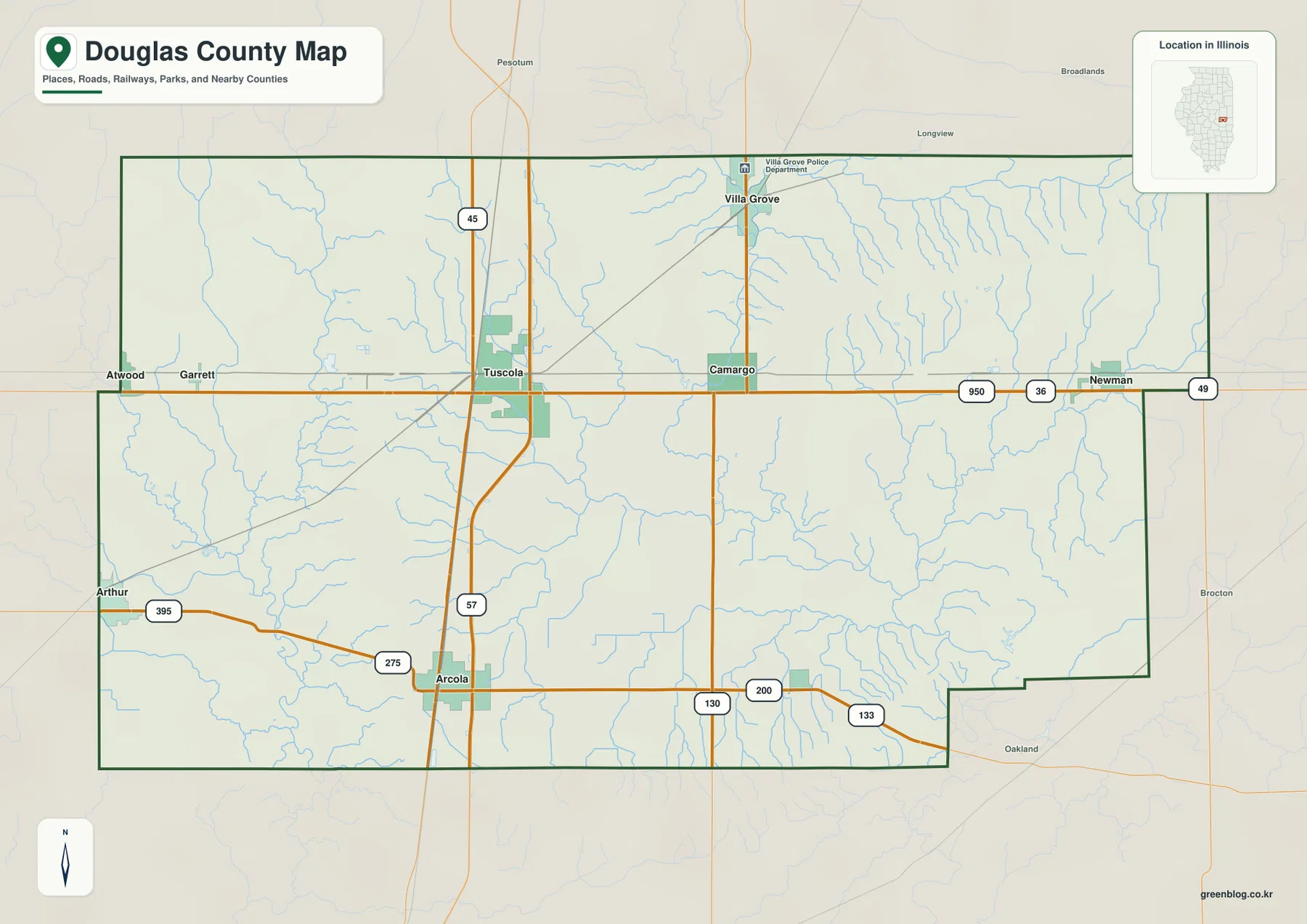
The stream network makes the apparently simple road grid more interesting. Small tributaries cross the Tuscola side repeatedly, and the northeastern county contains an especially dense pattern of short drainage lines. The south also has numerous branching creeks. Major roads remain fairly straight, while the waterways bend around low terrain, so reading both layers together gives a more realistic sense of the county’s surface.
Tuscola has been the county seat since 1860
Illinois State Archives lists Camargo as the temporary county seat from 1859 to 1860 and Tuscola from 1860 to the present. The current Douglas County Courthouse is also located in Tuscola. Camargo remains an important central-eastern town on the map, but the administrative center is Tuscola.
Six city markers spread from Villa Grove to Arcola and Newman
The simplified city graphic ranks Tuscola first, Arcola second, Villa Grove third, Arthur fourth, Newman fifth, and Camargo sixth. Its printed CITY INDEX lists 4,808 for Tuscola, 2,892 for Arcola, 2,349 for Villa Grove, 2,083 for Arthur, 882 for Newman, and 456 for Camargo. The image does not show a census year or statistical reference date for those values.
Because the index is undated, this article does not present the figures as current population counts. Their placement is still useful. Tuscola occupies a central-western position, Villa Grove stands well north, Arcola lies southwest, Newman reaches toward the east, and Arthur provides the western outer reference. Camargo fills the central-eastern gap between Tuscola and Newman.
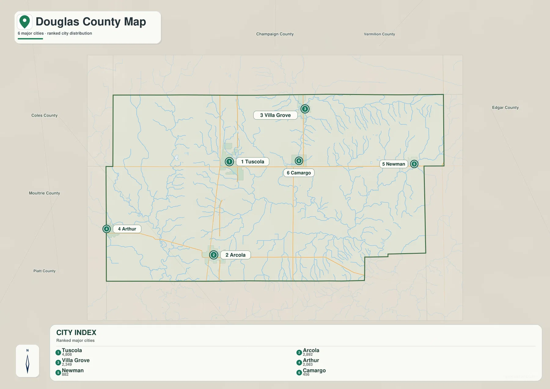
The selected places make the county’s width easy to remember. Tuscola and Camargo form part of the central line, while Villa Grove extends the pattern north and Arcola extends it south. Arthur and Newman pull the view toward opposite sides of the county. Once those six positions are familiar, the detailed road and water maps are easier to use without losing orientation.
The CITY INDEX is undated map data
Current population figures should come from a source with a stated reference year, such as the U.S. Census Bureau. The supplied CITY INDEX does not provide that date. Here, the numbers are used only to describe the marker ranking and relative emphasis printed on the map.
Kaskaskia and Embarras rivers divide the drainage story
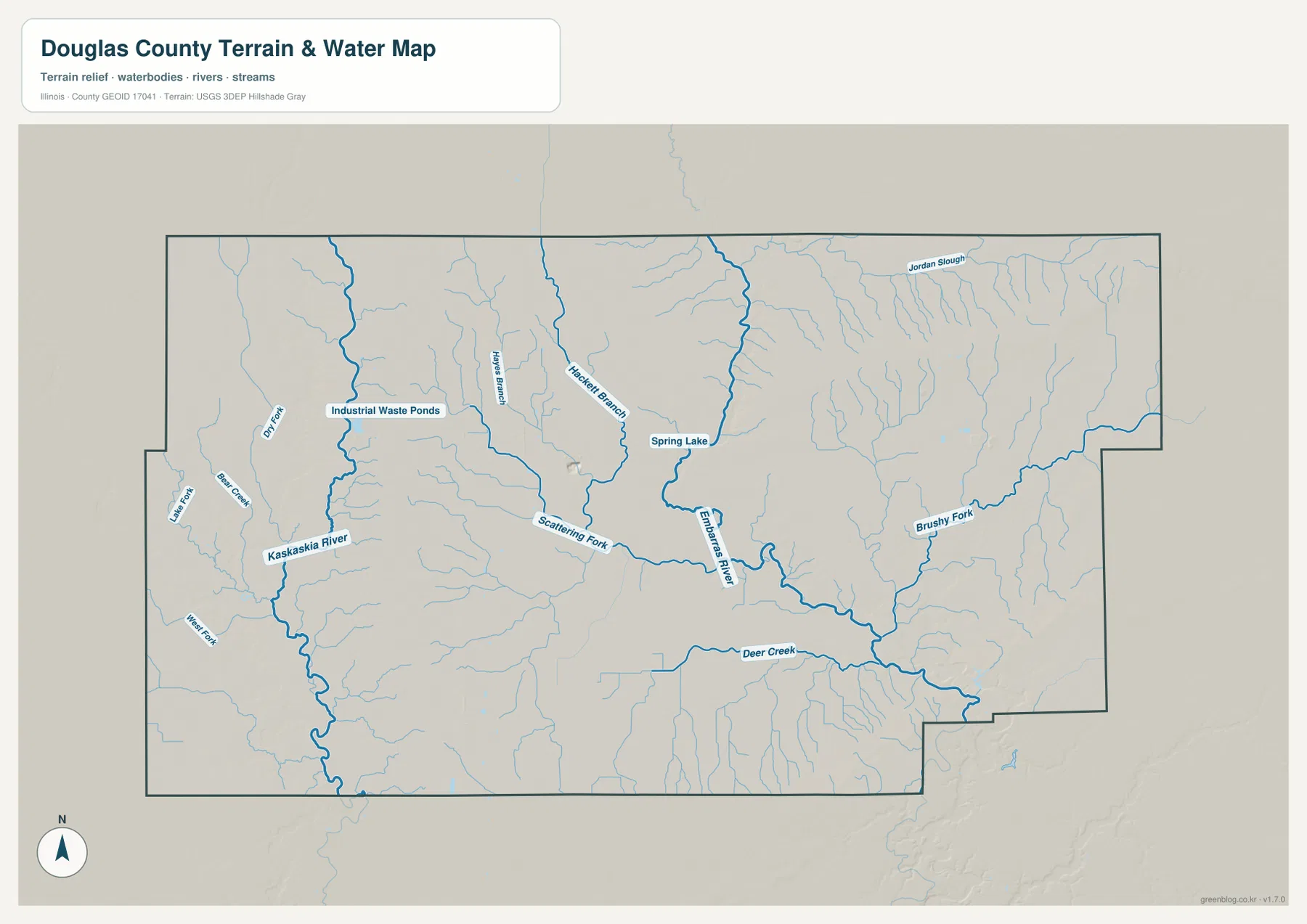
Kaskaskia River is the major named channel on the western side of the terrain-and-water map. It runs south through a low corridor, joined by Dry Fork and smaller tributaries. Farther east, Hackett Branch and Scattering Fork descend through the central county toward the Embarras system, creating long low drainage lines between the higher belts.
Embarras River bends through the central-eastern county and passes close to Spring Lake. Brushy Fork approaches from the east, while Deer Creek forms a long southern drainage line. Jordan Slough is labeled in the northeast. The county therefore has two large river references with several smaller forks and creeks occupying the ground between them.
Upper Embarras Woods provides a local example of the river landscape in southeastern Douglas County. Illinois DNR describes the preserve within Walnut Point State Park as old-growth oak forest on bluffs near Embarras River, with the river itself recognized as a biologically significant stream. That official local setting helps explain why the supplied terrain map shows the Embarras corridor as more than a simple line across open ground.
The water map does not show current river or flood conditions
The terrain sheet locates rivers, creeks, a slough, and a lake relative to the county terrain. It does not provide current Kaskaskia or Embarras river stages, flood-hazard boundaries, water depth, or access conditions. For present-day safety or river use, consult current USGS, Illinois DNR, or other responsible-agency information.
Northern uplands stand above the two river valleys
The elevation image shows the strongest higher terrain in the north-central and northeastern county. Broad orange and brown belts occupy those areas, but tributary valleys cut green channels through them. The central Embarras-Scattering Fork corridor drops lower, and the Kaskaskia side in the west also follows a lower green route. Smaller southern valleys repeat the same relationship on a finer scale.
The map prints an actual countywide elevation range of about 102 to 225 meters and a mean near 201 meters. Most of the color legend, however, is concentrated between roughly 192 and 214 meters. That difference matters: the 102-meter endpoint is part of the full county dataset and should not be treated as the typical elevation of the county or assigned directly to Tuscola, Arcola, Villa Grove, or another town.
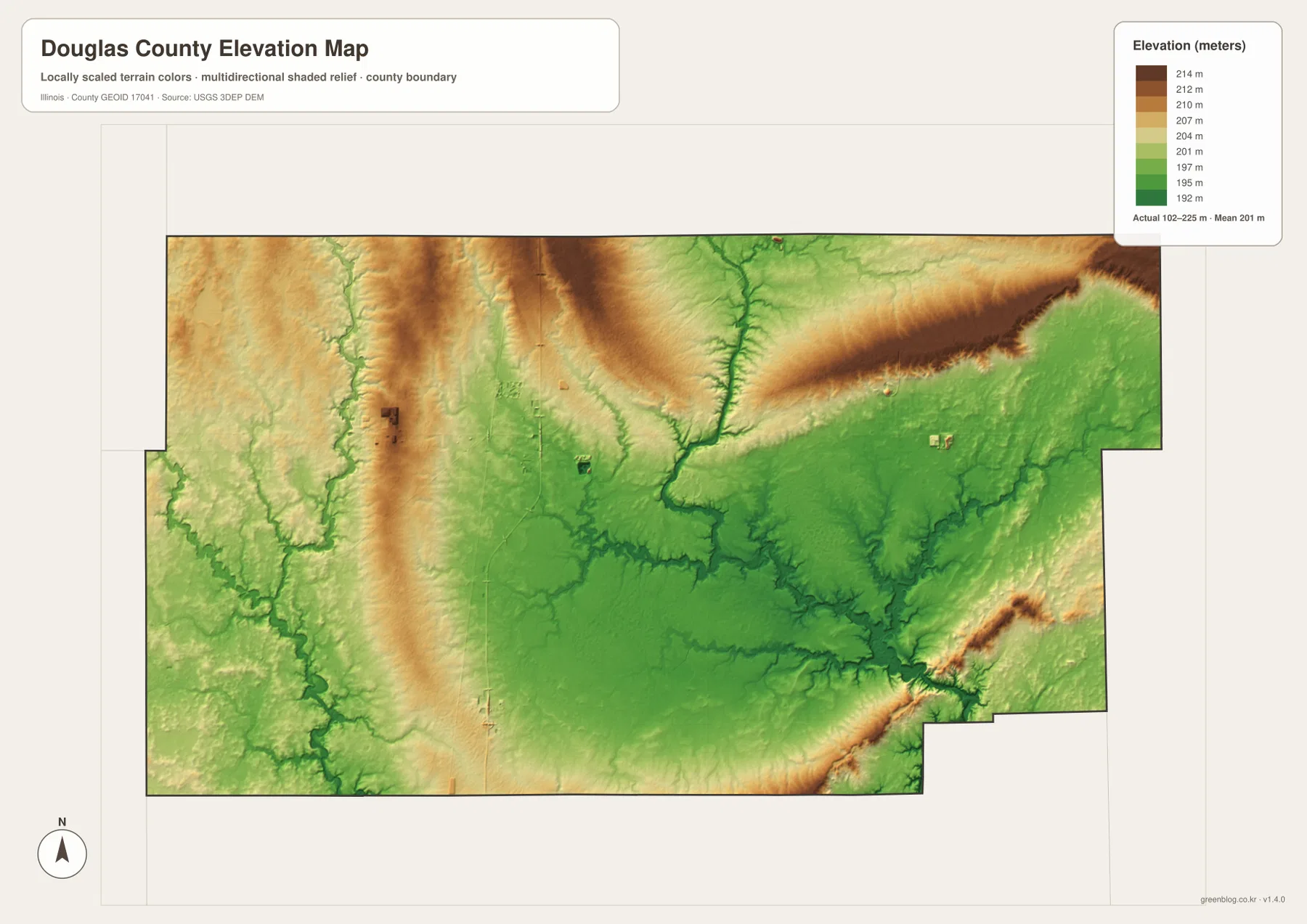
Matching the water and elevation maps makes the green corridors easier to interpret. Kaskaskia River, Embarras River, Scattering Fork, and Deer Creek all occupy terrain below nearby uplands. The northern ridges are repeatedly interrupted by small tributaries, while the central-eastern drainage creates a broader low area where several waterways meet. The road map alone does not show this contrast nearly as clearly.
102 to 225 meters is a countywide range
A building site, road grade, drainage plan, or parcel needs point-specific elevation data or a professional survey. The 102–225 meter range is most useful for comparing broad uplands and river valleys across Douglas County, not for assigning an exact elevation to a named town or address.
Keep Tuscola fixed while switching between towns, water, and relief
A practical way to use the files is to keep Tuscola fixed while changing the information layer. On the overview, locate Villa Grove north, Arcola southwest, Newman east, and Arthur west, then add Camargo to the central-eastern line. The city map simplifies those same relationships and makes the spacing between the six selected communities easier to remember.
Next, switch to the terrain sheet and separate Kaskaskia River on the west from Embarras River in the central-east. Scattering Fork and Deer Creek fill the lower ground between and below them. The elevation map completes the comparison by showing higher northern belts above those drainage corridors. Using the same landmarks across the files keeps towns, roads, water, and relief connected.
Use current transportation sources for driving conditions, dated Census data for population, current agencies for river or flood questions, and point-level elevation or survey data for site work. Within those limits, the Douglas County maps are useful for printed references, lessons, presentations, and advance geographic orientation.
Frequently Asked Questions
What is the county seat of Douglas County, Illinois?
Tuscola is the current county seat. Illinois State Archives records Camargo as the temporary seat from 1859 to 1860 and Tuscola from 1860 to the present. The current Douglas County Courthouse is also located in Tuscola.
Where does Embarras River run through Douglas County?
On the supplied terrain map, Embarras River bends through the central-eastern county and continues south, with Scattering Fork and Brushy Fork among the nearby named tributaries. Upper Embarras Woods in southeastern Douglas County is also protected along this river corridor.
Does 102 to 225 meters give Tuscola’s elevation?
No. The elevation image identifies 102–225 m as the actual range across the Douglas County dataset and gives a mean of about 201 m. Exact elevation for Tuscola or any specific road, building, or property requires point-specific elevation or survey data.
Sources and Reference Material
The article uses the supplied Douglas County maps together with the official references below. For current roads, river stages, preserve rules, legal boundaries, or exact point elevations, consult the responsible agency’s latest material rather than relying on a static county reference map.
- Douglas County Official Website – current county government and Tuscola courthouse information
- Illinois State Archives – Douglas County – county establishment and Camargo-Tuscola county-seat history
- Illinois DNR – Upper Embarras Woods – Embarras River bluffs and old-growth forest in Douglas County
- USGS National Hydrography – river, stream, and lake reference data
- USGS 3D Elevation Program – elevation and terrain data
Map File Information
The ZIP file contains the high-resolution JPG originals for the Douglas County overview, city map, terrain-and-water map, and elevation map. Each landscape image measures 3,638 × 2,572 pixels, preserving town labels, road numbers, smaller creek names, and terrain colors more clearly when enlarged or printed.
- Included Files: 4 high-resolution JPG maps
- Printable Size: 3,638 × 2,572 pixels each
Related Maps
Green Map creates custom-edited map images using open geographic data sources such as geoBoundaries, Natural Earth, OpenStreetMap, and government open data.
These maps are edited visual materials, not raw data files, and are provided for education, documents, presentations, and graphic reference.