Hartley County occupies a broad piece of the northwestern Texas Panhandle, where communities are separated by long stretches of open High Plains country. The clearest settlement references on the supplied maps are Dalhart at the northern edge and Channing in the southeast, with Hartley farther east of center and Romero near the southwest. US 87 provides the most obvious diagonal road connection between the northern and southeastern parts of the county.
You can download the same map set shown on this page as high-resolution JPG files in one ZIP archive. The county map is best for roads and place names, the city map makes the contrast between Dalhart and Channing easy to see, the water map traces Rita Blanca Creek and western tributaries, and the elevation map shows how the western uplands fall into deeply cut drainage corridors.
The county can look almost uniformly flat at first glance, but the terrain and water maps tell a more detailed story. A pronounced north-south valley follows Rita Blanca Creek through the middle of the county, while a network of creeks cuts into the western and southern uplands. That contrast between broad tableland and incised drainage is one of the most useful features to keep in mind while reading the road map.
Table of Contents
Dalhart and Channing sit at opposite ends of the county map
Dalhart is shown close to the northern boundary, while Channing lies far to the southeast near the Hartley County Courthouse marker. The two places are not part of a continuous built-up corridor; they are separated by a large expanse of ranch and farm country. Hartley appears east of center along the US 87 corridor, giving the map a useful middle reference between Dalhart and the southeastern part of the county.
Romero provides a very different reference point in the southwest. It is shown along US 54 near a much sparser road pattern and close to the western drainage network. Comparing Romero with Hartley makes the internal contrast easy to see: the eastern side has more closely spaced roads and labeled routes, while the southwest is dominated by open terrain and creek valleys.
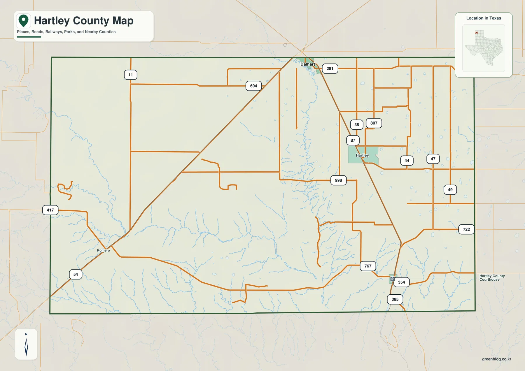
US 87 is the strongest road line on the map, running southeast from Dalhart through Hartley and toward Channing. US 54 enters the southwest near Romero, while route labels 354 and 385 appear near the southeastern edge. Smaller numbered roads such as 998, 767, and 722 fill in local connections. These lines are useful for geographic orientation, but the map is not a substitute for current turn-by-turn navigation.
The city index shows a striking gap between Dalhart and Channing
The city-distribution map ranks only two major places. Dalhart is marked number 1 with a value of 7,902, while Channing is number 2 with 242. The difference is visually dramatic and helps explain why the northern edge of the county carries a much stronger urban reference even though Channing is the county seat.
The simplified city map removes most minor roads, so the distance and direction between the two places stand out more clearly than on the general county map. Dallam County is labeled to the north, Oldham County to the west, and Moore, Sherman, and Potter counties along the east side. Those surrounding labels make Hartley County’s position within the upper Texas Panhandle easy to recognize.
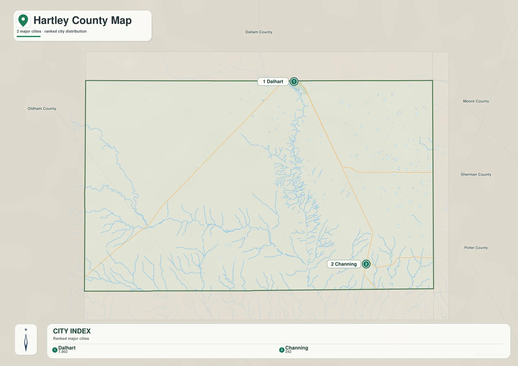
The index values are most useful as a map comparison rather than a complete description of local service areas or commuting patterns. For locating Hartley, Romero, and the network of smaller roads, the county map remains the better choice. The city map is strongest when the question is simply where the two main population references lie relative to the county boundary.
US 87 forms the clearest road spine through the eastern half
Road density is noticeably higher in the east and northeast. US 87 cuts diagonally across this side of the county, and roads labeled 38, 807, 44, 47, and 49 create a more regular network around Hartley. Farther north, 11 and 694 provide additional east-west references, while 998 crosses the middle portion of the county and connects into the southeastern road system.
The western half feels much more open. Outside the US 54 corridor near Romero and route 417 at the western edge, long stretches contain fewer major road lines. Creek channels become more visually important there, especially once the county map is compared with the terrain-and-water map. This east-west contrast is one of the reasons a single road map does not fully explain Hartley County’s geography.
Rita Blanca Creek cuts a deep corridor through the center
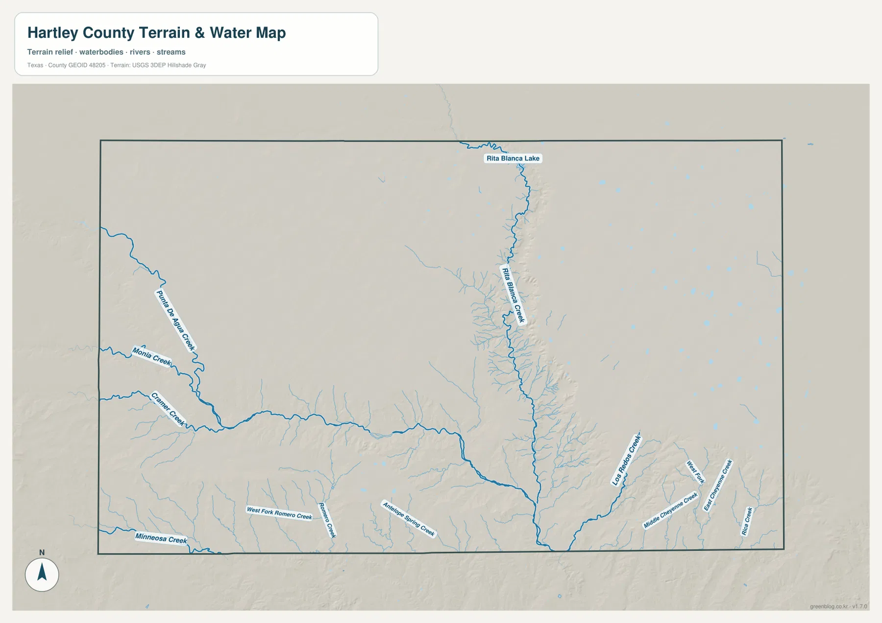
The water map is dominated by Rita Blanca Creek. It enters from the north near Rita Blanca Lake and continues south through the central part of the county, with many short tributaries joining from both sides. The branching pattern makes the central valley look very different from the broad, lightly dissected uplands around it.
Western Hartley County has its own distinct drainage pattern. Punta de Agua Creek runs southeastward, with Mania Creek and Cramer Creek labeled nearby. Minneosa Creek follows the southwestern edge, while West Fork Romero Creek, Romero Creek, and Antelope Spring Creek appear farther south. The important point is not to memorize every name but to notice how the western upland is cut by several long drainage lines before they approach the lower central and southern terrain.
The southeast contains another cluster of named streams, including Los Ratones Creek and Middle Cheyenne Creek, plus smaller branches around them. This is also an area where the elevation surface becomes more finely dissected. The water map is intended for comparing streams, drainage, and terrain reference points; it should not be treated as a flood-risk map, navigation chart, parcel map, or statement of legal water boundaries.
Elevation falls from the western uplands into the creek valleys
The elevation legend gives an actual range of about 1,019 to 1,362 meters, with a mean near 1,201 meters. Brown and orange cover much of the west and northwest, indicating the county’s higher upland surface. The eastern side is generally lower, but the most obvious low feature is the green north-south corridor carved along Rita Blanca Creek.
Shorter green valleys branch into that central corridor from both sides. Similar cuts appear across the southern edge, where the drainage network is densest. When the elevation and water maps are viewed together, many stream lines match lower terrain, making it easy to distinguish the broad High Plains surface from the valleys that have cut into it.
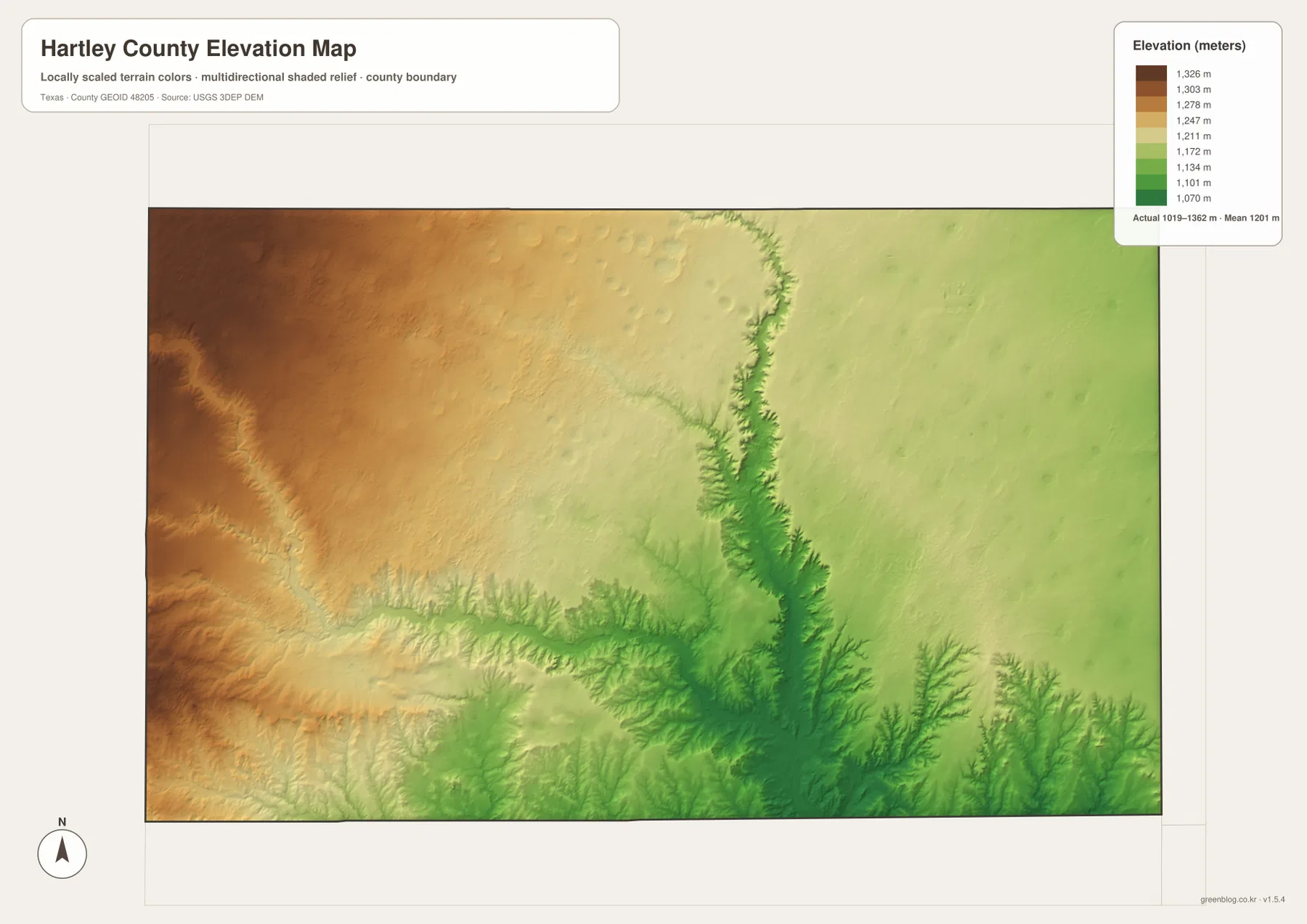
This elevation layer is a generalized county-scale surface, not a survey or engineering measurement for an individual property. Its value is in showing broad differences: the higher western tableland, the lower eastern surface, the central Rita Blanca valley, and the branching southern drainage cuts. For site-level elevations, an authoritative survey or detailed elevation dataset should be used instead.
Hartley and Romero reveal the county’s east-west contrast
Hartley sits in the eastern half close to US 87 and a relatively dense grid of numbered roads. From there, the highway continues north toward Dalhart and southeast toward the Channing area. Romero, by contrast, lies in the southwest along US 54, close to western creek systems and a much more open road pattern.
Using those two places as reference points makes the county easier to describe without reducing it to a generic High Plains landscape. The east has more visible road structure and labeled settlement points, while the west and southwest emphasize elevation, open upland, and drainage. That distinction remains clear across the general, water, and elevation maps even though each layer highlights different details.
Choose the map file according to the question you need to answer
Use the county map when you need Dalhart, Hartley, Channing, Romero, US 87, US 54, and local road numbers on one page. Use the city map when the main task is comparing the two major population references without road clutter. The water map is better for Rita Blanca Creek and the western tributaries, while the elevation layer is the clearest choice for showing the difference between upland surfaces and cut valleys.
For a classroom or presentation, the maps can also be read in sequence. Find US 87 and Hartley on the county map, move to Rita Blanca Creek on the water map, and then compare the same corridor on the elevation layer. That sequence shows how roads, settlements, drainage, and relief fit together without forcing every type of information onto a single image.
The WebP images in the article are optimized for on-screen viewing, while the ZIP provides the larger original JPG versions. Because each topic is separated into its own file, you can print only the road-and-place map, use the water layer for a drainage discussion, or select the elevation file when terrain is the main subject.
Frequently Asked Questions
Where should I start when reading a Hartley County map?
Start with Dalhart on the northern edge and Channing in the southeast, then follow US 87 between the two parts of the county. After that, locate Hartley east of center and Romero in the southwest. Those four references make the settlement and road pattern much easier to organize.
Which map shows Rita Blanca Creek most clearly?
The terrain-and-water map provides the clearest view. Rita Blanca Creek runs from the northern edge near Rita Blanca Lake through the center of the county and is joined by many short tributaries. The elevation map adds useful context because the same corridor appears as a lower green valley.
What elevation range is shown for Hartley County?
The legend reports an actual range of about 1,019 to 1,362 meters and a mean near 1,201 meters. Western uplands are generally higher, while Rita Blanca Creek and several southern drainage corridors are lower. These are county-scale reference values, not survey-grade elevations for individual sites.
Sources and Reference Data
County boundaries, roads, and place references can be checked through the U.S. Census Bureau TIGER/Line Shapefiles.
Streams, creeks, and waterbody references are available from USGS National Hydrography.
Elevation data and 3DEP information are documented by the USGS 3D Elevation Program.
For a combined view of several federal map layers, use the USGS The National Map Viewer.
Map File Information
Download the original high-resolution JPG files that match the Hartley County maps shown in this article in one ZIP archive.
- File Type: JPG
Related Maps
- Oldham County Texas map
- Sherman County Texas map
- Potter County Texas map
- Armstrong County Texas map
- Roberts County Texas map
Green Map creates custom-edited map images using open geographic data sources such as geoBoundaries, Natural Earth, OpenStreetMap, and government open data.
These maps are edited visual materials, not raw data files, and are provided for education, documents, presentations, and graphic reference.