This Sherman County Texas Map set is built around the features that stand out clearly in the supplied maps: Stratford as the main road reference, Texhoma on the northern edge, U.S. 54 and U.S. 287 as the most prominent highway lines, the North Canadian River and several named creeks, and an elevation surface that drops from the higher west toward lower eastern valleys. The maps can be viewed in the article, and the download box below provides matching high-resolution A3 JPG files for printing or editing.
Sherman County looks simple at first because the county outline is regular and many roads run in straight segments. The natural terrain tells a different story. Streams curve across the northern and central parts of the county, and the elevation map reveals deeply cut valleys within the broader High Plains surface. Reading the four maps together makes it easier to connect Stratford and Texhoma with the roads, watercourses, and relief that surround them.
Table of Contents
Stratford makes U.S. 54 and U.S. 287 easy to follow
Stratford appears in the western half of the county and is the clearest place to begin on the reference map. U.S. 54 approaches from the southwest, crosses the Stratford area, and continues northeast toward Texhoma. U.S. 287 passes through the same area on a strong north-south course. Those two highways create a simple framework for orientation before the reader turns to the many smaller numbered roads spread across the rest of the county.
Texhoma is placed along the northern boundary, northeast of Stratford. Smaller labels such as Stevens appear between the main communities, while Brice is shown west of Stratford. South of the county, Cactus and Sunray provide additional regional reference points. These surrounding labels help show how the county road network extends beyond the boundary without requiring a separate regional map.
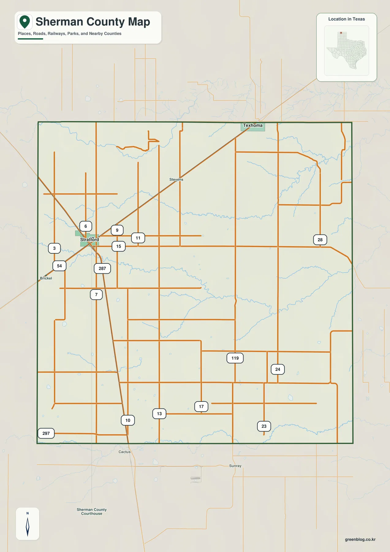
The contrast between roads and drainage is already visible on this general map. Many highways and local roads are straight, while the blue stream lines bend across the north and east. This is why the reference map works best as the first layer: it establishes the settlement and road pattern, and the terrain-and-water map can then explain the more irregular natural features.
Stratford and Texhoma form a simple two-city reference
The ranked city map reduces the settlement layer to Stratford and Texhoma. Stratford is shown as number 1 in the western-central part of the county, while Texhoma is number 2 on the northern edge. With secondary road shields removed, the distance and direction between the two communities become easier to see, and the surrounding county boundaries remain visible for orientation.
The CITY INDEX printed at the bottom lists Stratford at 1,326 and Texhoma at 336. These figures are the values used by the supplied map to rank the two places. They should not be treated as guaranteed current population estimates; a project that needs the latest demographic count should use an official statistical source. For map reading, however, the index explains the numbered city markers clearly.
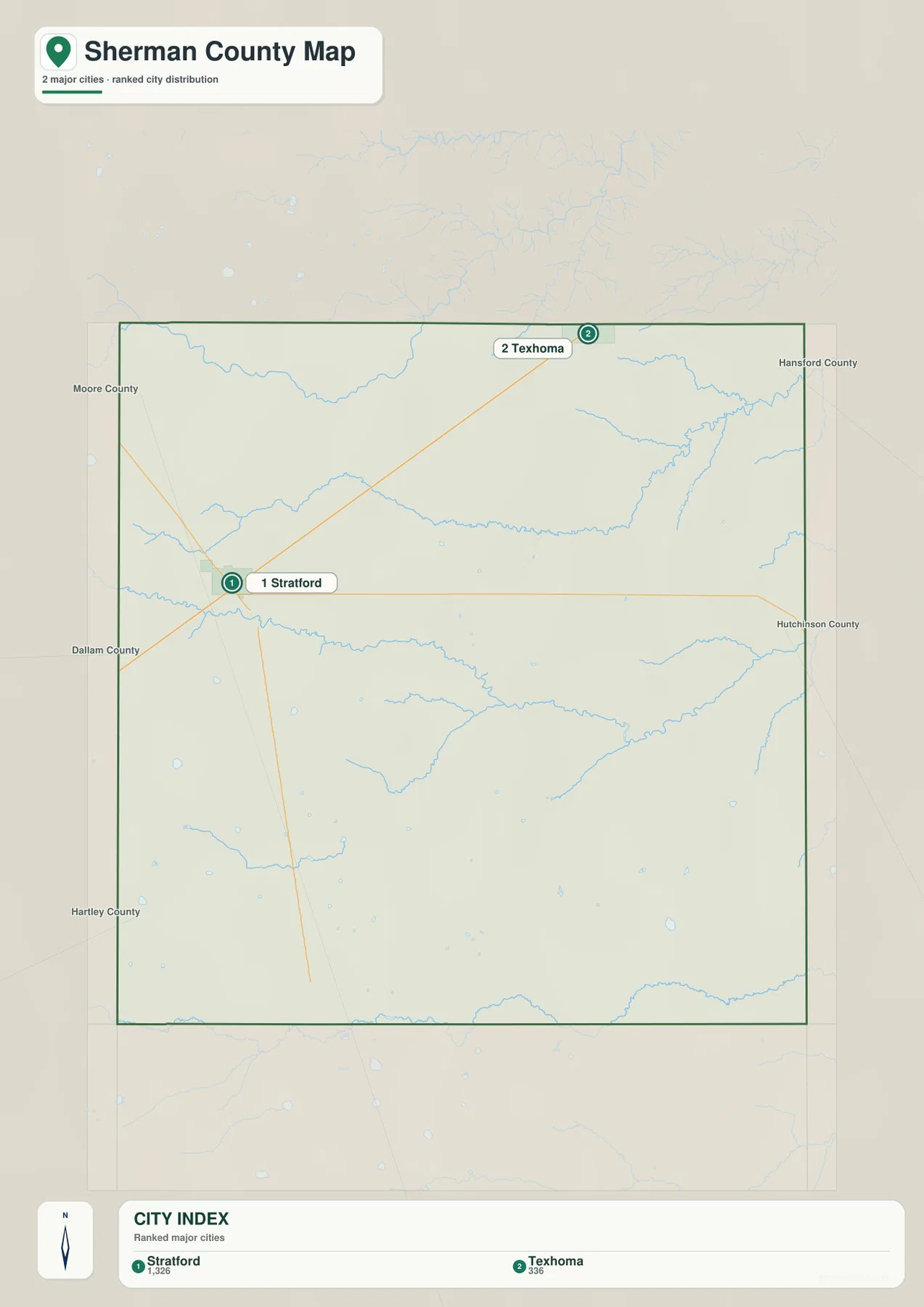
Because only two places are emphasized, the map is useful for a county overview, classroom page, or presentation that needs a clean settlement reference. Returning to the full county map after viewing this version makes U.S. 54 especially easy to understand because it follows the same general southwest-to-northeast direction between Stratford and the Texhoma side of the county.
North Canadian River and Coldwater Creek reveal the valley network
The terrain-and-water map gives the strongest visual emphasis to the North Canadian River in the northwest. South of it, Fisco Creek crosses the northern interior, while Coldwater Creek forms a long winding channel through the middle of the county. These waterways contrast sharply with the straight road grid and make it clear that the landscape contains broad drainage valleys even though the county boundary itself is regular.
North Palo Duro Creek is labeled in the southeast, creating another strong drainage reference away from the northern river system. Pleasure Pond appears in the central-eastern area, and Elephant Lake is marked farther west and south. The smaller blue channels between these named features show that drainage is distributed across the county rather than concentrated in a single river valley.
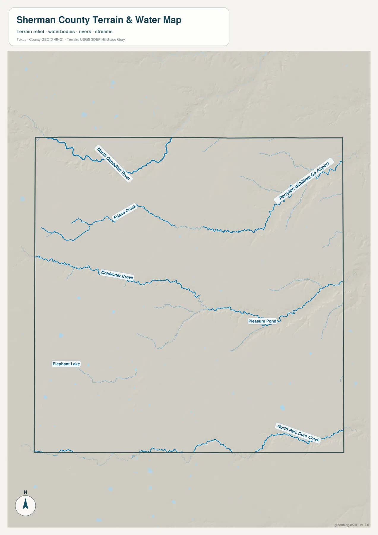
A practical way to read the map is to begin with the North Canadian River in the northwest, move south to Coldwater Creek through the center, and then look toward North Palo Duro Creek in the southeast. Smaller tributaries fill the spaces between those references. This is a geographic water-reference map, not a flood-risk map, parcel map, legal-boundary product, or navigation chart.
Higher western ground steps down into lower eastern valleys
The elevation map reports an actual range of about 969 to 1,161 meters and a mean elevation of 1,077 meters. Brown and tan colors dominate the west and northwest, showing the highest terrain in the county. Moving eastward, the colors shift through yellow and light green, and much of the eastern half is noticeably lower.
The change is not a smooth, featureless slope. Deep green valleys cut into the higher western and central surface, especially where streams have carved drainage corridors. The eastern half contains broader low areas and branching valleys. When the elevation and water maps are compared, many of those low corridors align with the same general paths followed by the named creeks.
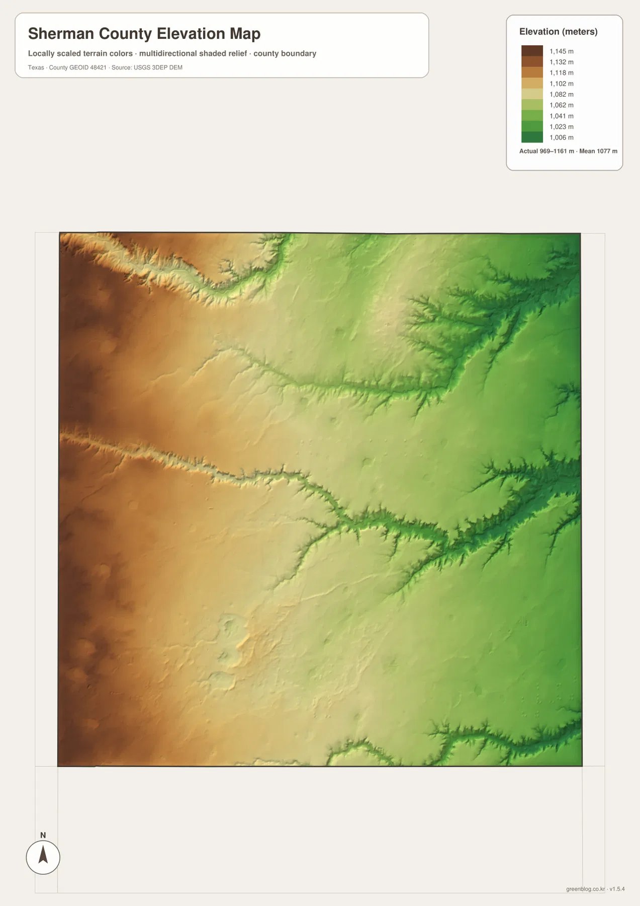
This countywide elevation surface is intended for broad terrain comparison rather than parcel surveying or engineering design. It is useful for seeing which parts of the county are relatively high, where creek valleys cut into the plains, and how the terrain changes from west to east. Precise site elevation should be checked with detailed source data or a local survey.
Choose the map according to roads, towns, water, or relief
Use the county reference map when Stratford, Texhoma, U.S. 54, U.S. 287, and the county boundary need to appear together. The ranked city map is cleaner when only the two main settlements should stand out. Choose the water map for the North Canadian River, Coldwater Creek, North Palo Duro Creek, Elephant Lake, and Pleasure Pond, and use the elevation map when the west-to-east terrain contrast matters most.
The WebP images in the article are convenient for quick on-screen viewing. For printing or editing, the ZIP below contains four matching high-resolution A3 JPG files: county reference, ranked city, terrain and water, and elevation. Because the files remain separate, you can print only the map needed for a classroom handout, local reference sheet, presentation, or personal project.
Frequently Asked Questions
Where is Texhoma in relation to Stratford?
On the supplied maps, Texhoma is northeast of Stratford and sits along the northern county boundary. U.S. 54 follows the same general direction from the Stratford area toward Texhoma.
Which waterways stand out on the Sherman County water map?
The North Canadian River is the strongest named watercourse in the northwest. Coldwater Creek crosses the central part of the county, North Palo Duro Creek is in the southeast, and smaller named waters include Elephant Lake and Pleasure Pond.
What elevation range is shown for Sherman County?
The supplied elevation map states an actual range of about 969 to 1,161 meters and a mean of 1,077 meters. The west and northwest are generally higher, while broad lower valleys become more prominent toward the east.
Map File Information
The ZIP contains the four Sherman County maps in high-resolution A3 JPG format.
- Included Versions: County reference, ranked city, terrain and water, elevation
- Included Files: 4 A3 JPG maps
Related Maps
Sources and data references
County boundaries and road reference data can be checked through the U.S. Census Bureau TIGER/Line Shapefiles. Rivers, creeks, and other hydrographic features can be cross-checked with USGS National Hydrography, while elevation data are available through the USGS 3D Elevation Program. The city index values, road labels, named waters, and elevation figures described above are based on the Sherman County maps supplied in the current ZIP package.
Green Map creates custom-edited map images using open geographic data sources such as geoBoundaries, Natural Earth, OpenStreetMap, and government open data.
These maps are edited visual materials, not raw data files, and are provided for education, documents, presentations, and graphic reference.