Candler County sits in inland southeastern Georgia, where Metter provides the main civic and service center for a largely rural county. The road pattern is easy to recognize once Metter is used as the reference point: Interstate 16 runs south of the city, State Route 46 continues east toward Pulaski, and several north-south state routes meet or pass close to the county seat. The county is not dominated by a large metropolitan area or a single lake. Instead, its geography is defined by one primary town, a smaller incorporated community, a branching network of creeks, and gently varying Coastal Plain terrain.
This page brings those features together in four map views without treating them as interchangeable. The county map is useful for boundaries, roads, and nearby places; the city map makes the Metter-Pulaski relationship easier to see; the water map brings named creeks, ponds, and the Canoochee River forward; and the elevation map shows the low but noticeable height differences between stream corridors and the ground between them. The browser images are WebP previews, while the downloadable ZIP contains four original A3 high-resolution JPG files for printing, presentations, and offline reference.
Table of Contents
Metter anchors the road pattern inside the county boundary
The general county map makes Metter the most practical starting point. The city label sits near the middle of Candler County, with Candler County Hospital and the sheriff’s office marked nearby. Pulaski appears to the east, while smaller local names such as Ollifftown add context within the county. Outside the boundary, labels including Twin City, Portal, Stillmore, Cobbtown, and Excelsior help a reader distinguish places that are near Candler County from places that are actually inside it.
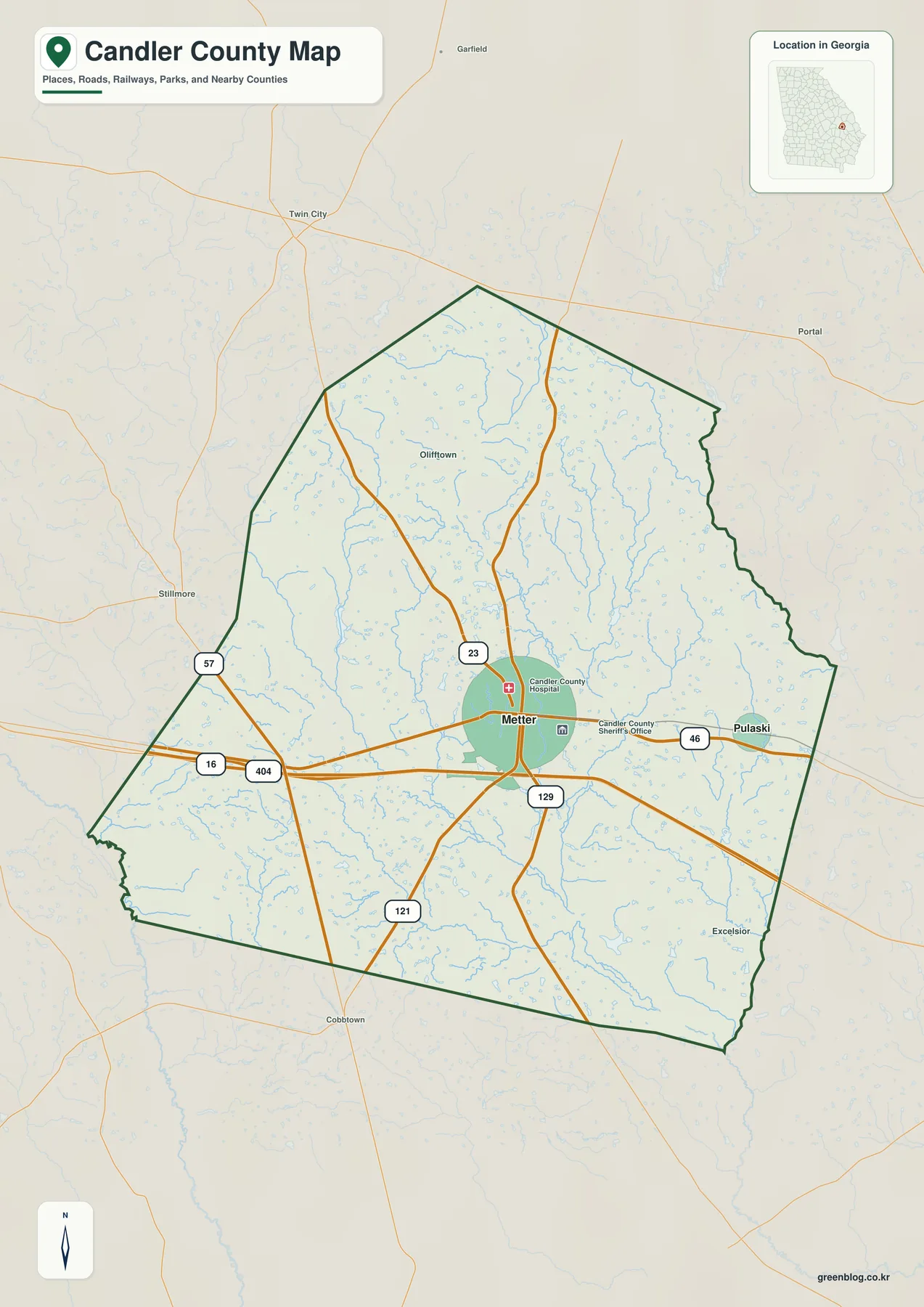
I-16 crosses the southern part of the county rather than running through central Metter. SR 46 provides the clearest east-west local connection from Metter toward Pulaski. The map also labels SR 23, SR 129, SR 121, and SR 57, so the county seat can be read as a junction of several local routes instead of a town located directly on the interstate. That distinction matters for visitors: an interstate exit associated with Metter is not the same location as downtown, and a short approach on connecting roads is still required.
The map is best used for county-scale orientation, not for parcel or legal work. It shows a generalized boundary and a selected road network, but it does not attempt to include every farm lane, unpaved county road, subdivision street, municipal limit, property line, or current construction notice. If the purpose is a deed, zoning question, emergency route, or precise address, the appropriate county or state GIS and current transportation information should take priority over this reference image.
The companion city map also identifies Jenkins, Bulloch, Toombs, Evans, Tattnall, and Emanuel counties around Candler. Those surrounding labels are useful because they show how compact Candler is within a broader group of southeastern Georgia counties. Rather than trying to memorize every boundary turn, a reader can first locate Metter, then use the neighboring county names and I-16 to place Candler within the region.
Metter and Pulaski form a simple two-place settlement pattern
Candler County has a straightforward incorporated-place pattern. The city map ranks Metter first and Pulaski second, reflecting the county seat’s much larger civic and service role. Metter is the place where the county’s main road connections, public facilities, and business activity are concentrated. Pulaski is a separate incorporated town east of Metter. Reading the map this way is more accurate than treating the two labels as equivalent urban centers simply because both are emphasized.
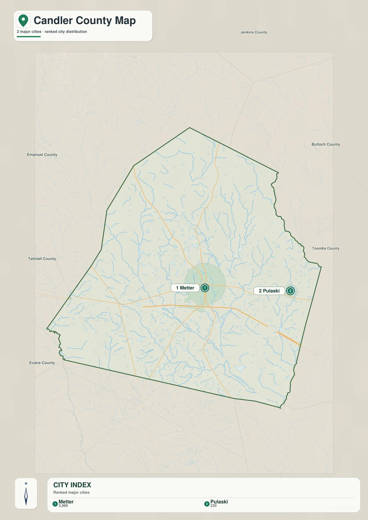
Pulaski lies east of Metter, with SR 46 providing the direct geographic link between them. That east-west relationship is an important correction to older descriptions that placed Pulaski north of the county seat. I-16, meanwhile, stays south of both city labels. The result is a clear three-part arrangement: Metter near the center, Pulaski farther east, and the interstate corridor below them. It is a useful pattern for a classroom map, regional overview, or a quick explanation of how local roads connect to the freeway.
The line between ranked cities should not be confused with a driving route. When a city-map version includes a connector distance, that measurement is a straight-line reference, not road mileage. Actual travel depends on the roads used, the starting point within each town, and any detour or construction condition. This distinction is especially useful in rural counties, where two places that appear close together may have only a few practical road connections.
For most readers, the city map works best as a simplified location diagram. It removes much of the road detail that competes for attention on the general map and makes the two incorporated places easy to find. It is not intended to replace a street map, turn-by-turn navigation, or municipal boundary data. Its strength is quick comparison: which settlement is central, which one lies east, and which neighboring counties surround the Candler County outline.
Creeks, ponds, and the Canoochee River shape the water map
The terrain-and-water map changes the emphasis completely. Roads fade into the background while streams and standing water become the main reference features. Fifteenmile Creek is labeled across the northern part of the county, and the Canoochee River is shown on the western and southern side. Between them, smaller waterways including Reedy Branch, Sams Creek, Little Stocking Head Creek, Wolfe Creek, and Tenmile Creek reveal how densely the county is divided by small drainage lines even though the landscape appears broadly flat from a distance.
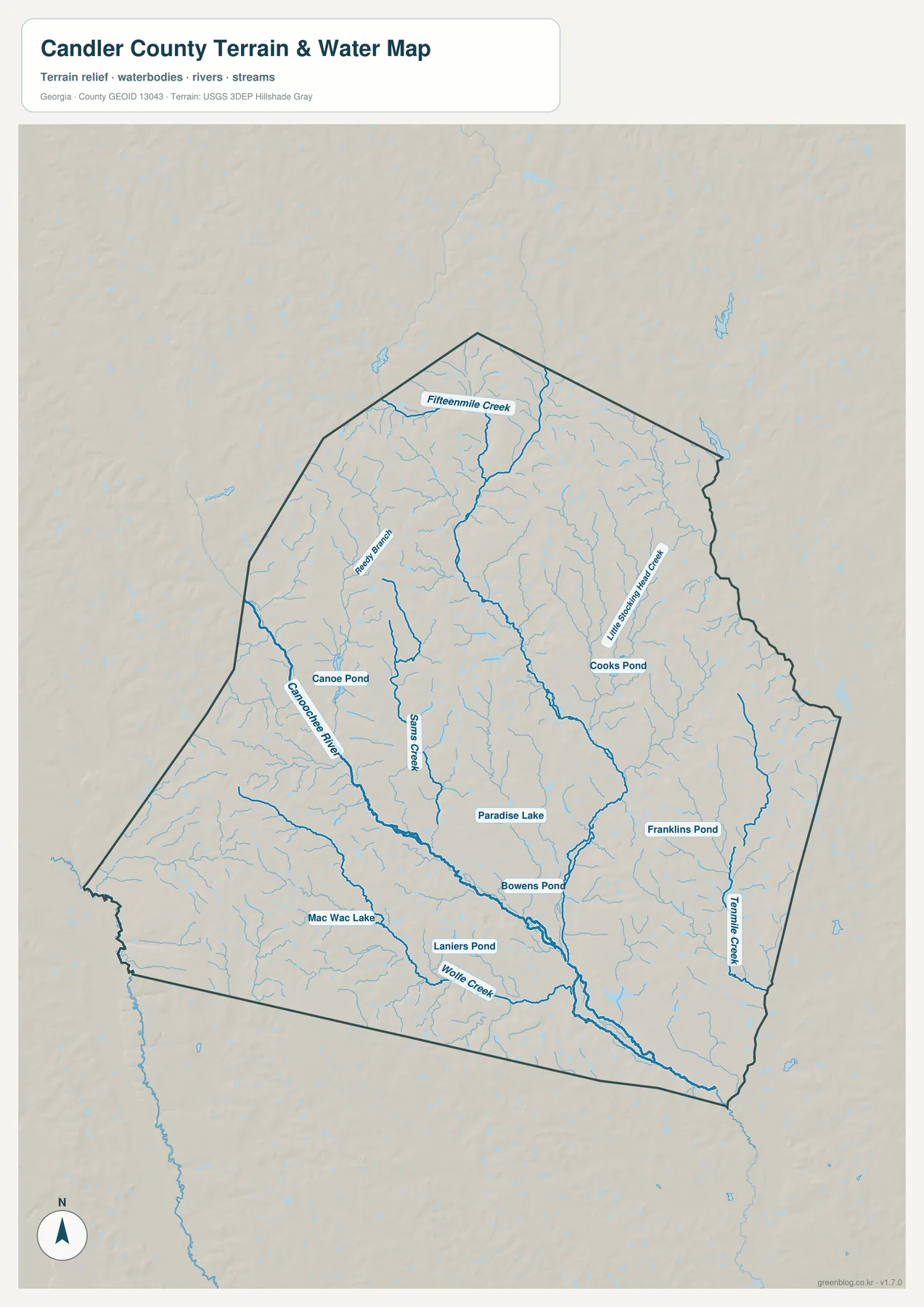
Several named ponds and lakes provide smaller landmarks: Canoe Pond, Cooks Pond, Paradise Lake, Franklins Pond, Bowens Pond, Mac Wac Lake, and Laniers Pond are all visible on the map. None of them functions as one dominant countywide reservoir. Instead, they are scattered among the stream network. That distribution is useful when matching a local place name to a nearby water feature or when explaining why a rural route may cross multiple small creeks within a relatively short distance.
Fifteenmile Creek is more than a decorative blue line. The source catalog supplied with this map package includes a USGS monitoring location near Metter, providing a current-data companion to the static image. The broader map, however, should not be interpreted as a flood-hazard product. It does not map inundation depth, flood probability, every minor ditch, or the status of bridges after a storm. For water levels, mapped flood hazards, or current closures, consult USGS, FEMA, Candler County, and Georgia DOT information.
The water map becomes especially informative when viewed beside the elevation image. Many of the lower corridors in the elevation model follow the same branching pattern as the streams. That does not mean every low-colored area is a permanent wetland or flood zone. It simply shows that drainage and local relief are related. The two maps together provide a clearer geographic explanation than either one can provide alone.
A 34–94 meter elevation range reveals subtle Coastal Plain relief
Candler County is a low-relief Coastal Plain county, but the elevation map shows that “flat” does not mean perfectly level. The map notes an actual elevation range of about 34 to 94 meters, with a mean near 64 meters. A sixty-meter spread is modest compared with a mountain county, yet it is enough to separate lower stream corridors from the gently higher ground between them. Those small differences can influence where water collects and where roads must cross drainage channels.
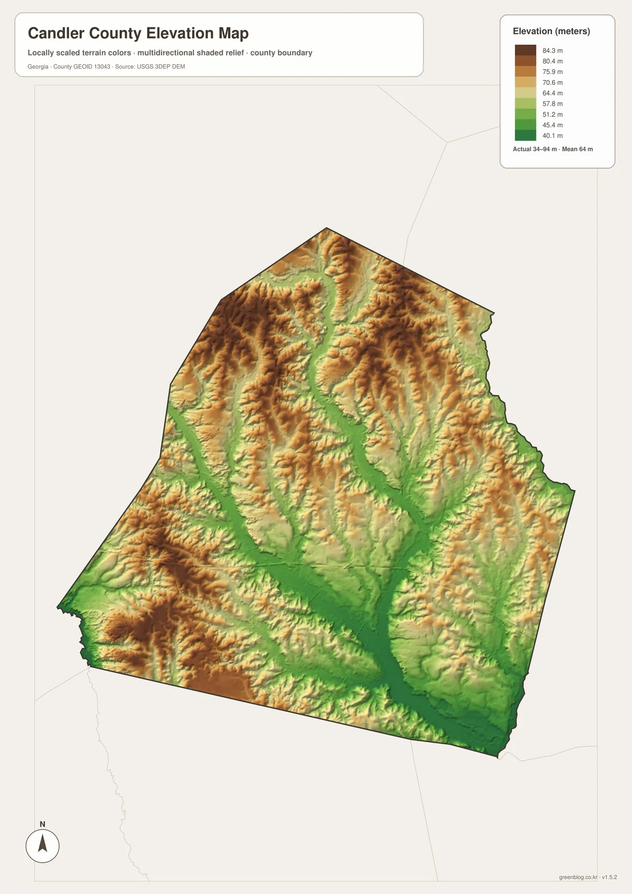
Green areas form branching low corridors through much of the middle and southern portion of the county, while tan and brown colors mark somewhat higher ground between those corridors. The shaded relief is intentionally strong enough to make subtle terrain visible on a page. It can therefore look more rugged than the actual numbers suggest. The correct interpretation is not “mountain ridges,” but gently raised interstream ground separated by lower valleys and creek bottoms.
This map is suitable for broad terrain comparison, not engineering or surveying. A road grade, building-pad elevation, drainage design, or legal elevation certificate requires source DEM data at the appropriate resolution or a field survey. For a county overview, though, the generalized surface does an important job: it explains why the water map contains so many branching channels even in a place with no dramatic mountains.
For teaching or presentation use, place the water and elevation maps next to each other and ask where the darkest stream lines coincide with lower green terrain. That simple comparison turns an abstract elevation number into something visible. It also makes clear why a straight county road network still has to respond to creek crossings and low ground, especially in the rural parts of Candler County.
County formation, population, and the continuing importance of Metter
Candler County was created in 1914 from parts of Bulloch, Emanuel, and Tattnall counties and became Georgia’s 150th county. It was named for Allen D. Candler, who served as governor of Georgia from 1898 to 1902. Metter predates the county: the community was founded in 1889 and incorporated as a town in 1903. The drive to create a new county with Metter as the seat began before 1914, and the county’s eventual formation fixed the administrative role that remains visible on today’s map.
The U.S. Census Bureau counted 10,981 residents in 2020 and lists a July 2025 estimate of 11,275. The 2020 land area is 243.06 square miles, with a population density of 45.2 people per square mile. Those figures fit the visual impression of the maps: one clearly dominant county seat, one much smaller incorporated town, and a large share of land outside dense urban development. The geography is easier to understand as a rural county organized around Metter than as a chain of similarly sized towns.
| State / FIPS | Georgia · 13043 |
|---|---|
| County seat | Metter |
| Incorporated places | Metter and Pulaski |
| Created | 1914 |
| 2020 population | 10,981 |
| 2025 population estimate | 11,275 |
| 2020 land area | 243.06 square miles |
| Elevation shown on map | about 34–94 m · mean about 64 m |
Pulaski remains important because it is the county’s other incorporated municipality, even though its scale is much smaller than Metter’s. The Georgia Department of Community Affairs groups Candler County with the cities of Metter and Pulaski in a joint comprehensive-planning context. On the map, that administrative relationship translates into a simple visual hierarchy: the county seat near the center and the smaller town to the east, connected by SR 46.
This history also helps explain why the general map is more useful when public facilities and road junctions are read together. Metter’s centrality is not just a cartographic choice. It reflects the county seat’s long-term administrative role, its larger population base, and the concentration of services around it. The surrounding rural roads and waterways then connect that center to less densely settled parts of the county.
Choose the map that matches the question you need to answer
A single map does not need to carry every type of information. For a quick regional overview, start with the county map because it combines the boundary, Metter, Pulaski, I-16, and selected state routes. If the goal is to explain the two incorporated places without extra road detail, the city map is cleaner. For named creeks, ponds, and the Canoochee River, the water map is the better reference. The elevation image becomes useful when the question is why those streams occupy lower corridors across an otherwise gently rolling surface.
- County orientation: use the general map for the boundary, Metter, Pulaski, I-16, and major state routes.
- Settlement comparison: use the city map to show Metter’s central role and Pulaski’s position to the east.
- Water features: use the water map for Fifteenmile Creek, Canoochee River, smaller tributaries, ponds, and lakes.
- Terrain context: use the elevation map for the 34–94 meter range and the relationship between lower drainage corridors and higher ground.
For print work, keep the map title, legend, scale context, and boundary visible rather than cropping tightly around one label. The A3 JPG files preserve more detail than a browser screenshot and are better suited to handouts or full-page reference sheets. They are still static reference maps, so pair them with current official sources when the task involves travel restrictions, property boundaries, flood hazards, or measurements that could change or require legal precision.
Frequently Asked Questions
Where is Pulaski in relation to Metter?
Pulaski is east of Metter, and SR 46 connects the two communities. The city map makes that east-west relationship clear. If a connector line or distance is shown, treat it as a straight-line reference rather than driving mileage; the actual road trip depends on the route and the exact starting and ending points.
Does I-16 pass through downtown Metter?
No. I-16 runs south of central Metter. The county map shows a visible gap between the interstate corridor and the city center, so travelers leave the freeway and use connecting state roads to reach town. An exit identified with Metter should therefore not be interpreted as the downtown location itself.
Can the water map be used as a flood-hazard map?
No. It is a geographic reference showing named rivers, creeks, ponds, and lakes. It does not show flood probability, inundation depth, current water levels, or bridge closures. Use USGS observations, FEMA flood-hazard products, and current county or Georgia DOT notices for decisions involving storms, flooding, or road safety.
Map File Information
Candler County A3 map files
- Included Files: county, city, water, and elevation JPG maps
- Printable Size: A3 high resolution, 2572 × 3638 px
Related Maps
Sources and official reference data
Population, county history, planning context, water observations, and transportation references can be checked against the sources below. For operational or safety decisions, use the most recent information published by the responsible agency.
- U.S. Census Bureau QuickFacts: Candler County population, area, and FIPS
- New Georgia Encyclopedia: Candler County formation, Metter, and Pulaski
- Georgia Department of Community Affairs: Candler County with Metter and Pulaski planning resources
- Official Metter website: community and county background
- USGS Water Data: Fifteenmile Creek near Metter
- Georgia Department of Transportation: official highway maps
Green Map creates custom-edited map images using open geographic data sources such as geoBoundaries, Natural Earth, OpenStreetMap, and government open data. These maps are edited visual materials, not raw data files, and are provided for education, documents, presentations, and graphic reference.