Download the Camden County Georgia Map files on this page as one ZIP containing four high-resolution A3 JPG maps for printing, class materials, presentations, or offline reference. The set covers the county boundary and major roads, city locations, waterways, and elevation, so you can compare the inland I-95 corridor with the much more intricate Atlantic coast. Camden County occupies Georgia’s far southeastern corner; Woodbine is the county seat in the northern half, while Kingsland and St. Marys form the larger southern cluster near Kings Bay and the St. Marys River. The county boundary also extends through tidal marshes, channels, and islands around Cumberland Island, which is why the separate map views are useful for understanding the area rather than relying on a simple outline alone.
The contrast between Camden’s inland and coastal sides is easy to see when the maps are compared. Interstate 95 stays west of the broadest tidal marshes and passes close to Kingsland, while St. Marys lies farther east near the St. Marys River, Kings Bay, and the approach to Cumberland Island. North of that southern cluster, the Satilla River and its tributaries cut across a mostly low Coastal Plain. Even the elevation map is dominated by low values, with the higher ground concentrated toward the western side rather than in any mountainous zone. These differences make Camden a useful county for understanding how roads, settlement, water, and terrain interact along the Georgia coast.
Table of Contents
Camden County at a glance
| State | Georgia |
|---|---|
| County seat | Woodbine |
| Main mapped cities | Kingsland, St. Marys, Woodbine |
| 2020 population | 54,768 |
| July 1, 2025 estimate | 60,143 |
| 2020 land area | 630.36 square miles |
| Main road context | I-95, US 17, and state/local routes |
| Major waters shown | Satilla River, St. Marys River, Crooked River, Cumberland River, Kings Bay |
| Coastal setting | Tidal marsh, channels, Cumberland Island, Atlantic shoreline |
| Download | ZIP with four high-resolution A3 JPG maps |
U.S. Census Bureau figures in the supplied material list 54,768 residents in 2020 and a July 1, 2025 estimate of 60,143. The same source gives 630.36 square miles of land for 2020. Those numbers help explain why the mapped cities occupy only a small part of the county’s total area. Large spaces between labels include rural land, wetlands, river corridors, federal property, and unincorporated areas rather than empty territory, and the coastal side contains extensive water and marsh that a road map can easily understate.
Roads, boundary, and the Woodbine-to-St. Marys layout
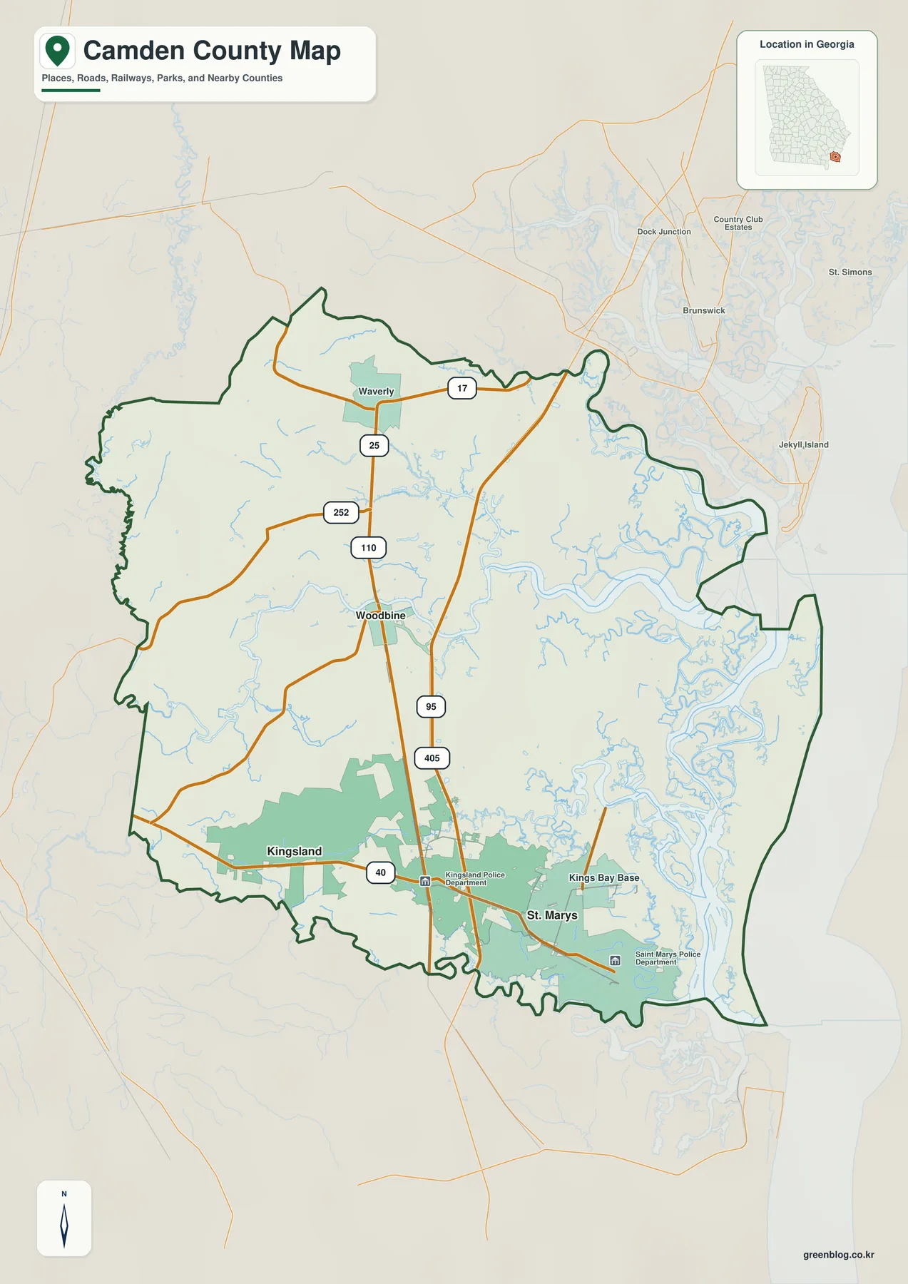
Woodbine appears north of the county’s midpoint and provides the administrative reference point, but the larger southern population cluster lies around Kingsland and St. Marys. Waverly is also labeled in the north, showing that settlement is not confined to the I-95 corridor. Interstate 95 runs north and south through the inland side of Camden and passes just east of Kingsland, while US 17 and state routes connect the Woodbine and northern areas. St. Marys sits farther east, beyond the main interstate corridor and closer to the river, Kings Bay, and tidal coast.
The eastern boundary is much more irregular than the western side because it follows a landscape of tidal channels, marsh, river mouths, and islands. On a small map, some of that shore can look like a single edge, but the water map makes clear that the county’s coastal side is divided by many channels. A place that looks close in a straight line may therefore require a longer road route, a bridge at a specific crossing, or water transportation. The map is most useful for orientation: it lets a reader see which places share the same general corridor and which are separated by marsh or open water.
Camden is bordered by Glynn County to the north, with Brantley and Charlton counties on the inland side, while the St. Marys River separates Georgia from Nassau County, Florida, along the south. The overview map is not a parcel or legal survey and should not be used to determine a property line, restricted access point, or exact shoreline position. For those purposes, current county GIS, road authorities, federal installation guidance, or other official detailed sources are more appropriate.
Kingsland as the hub between Woodbine and St. Marys
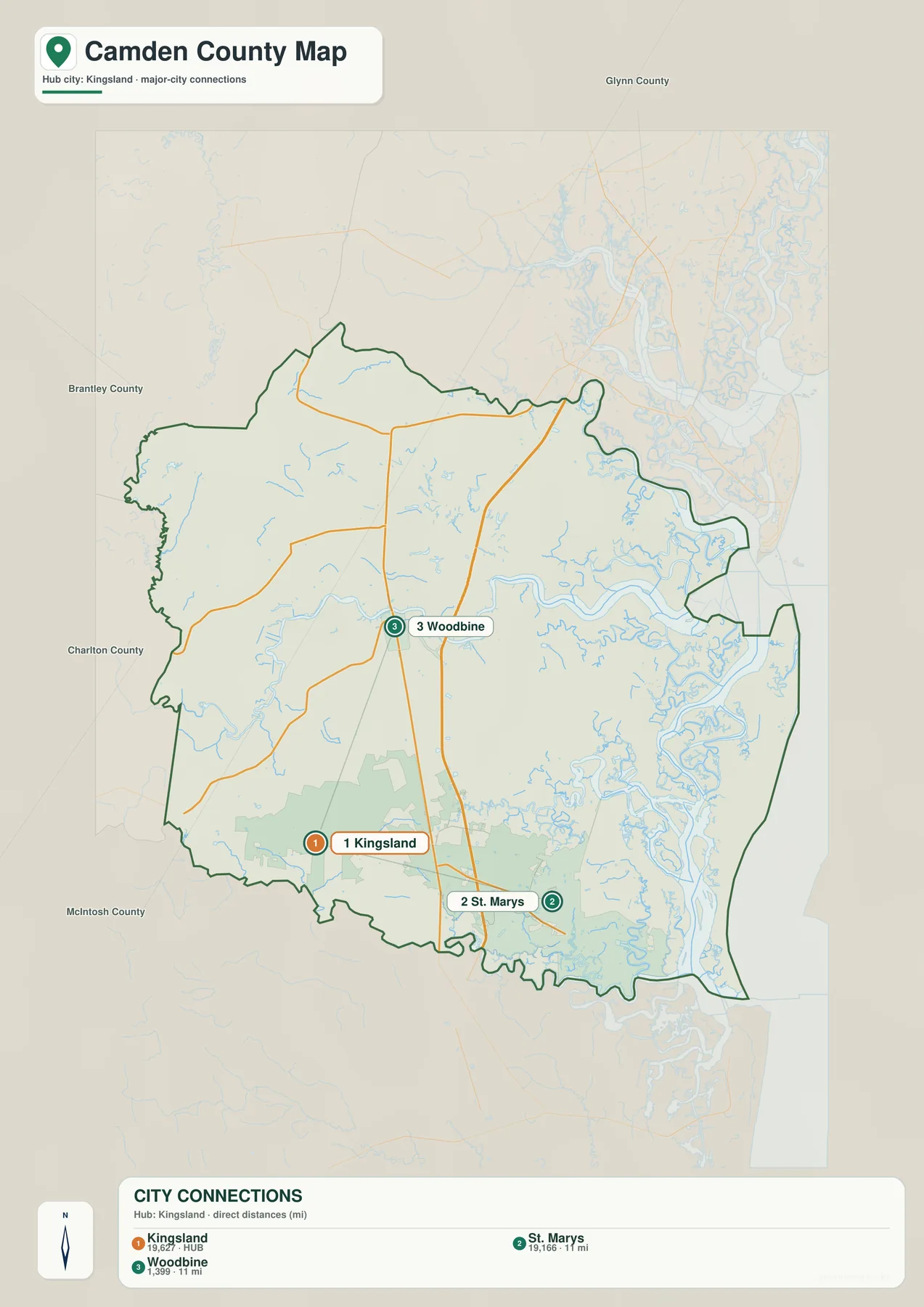
The city map simplifies Camden to three principal municipal reference points. Kingsland is the hub, Woodbine lies to the north, and St. Marys is southeast of Kingsland near the coast. Both connector labels are about 11 miles from Kingsland, but they are direct straight-line distances rather than road mileage. That distinction matters here because the northern trip follows a largely inland corridor, while the eastern trip toward St. Marys approaches wetlands and tidal waterways. Equal-looking distances on the diagram should not be read as equal travel times.
The hub symbol also should not be confused with county-seat status. Woodbine remains the county seat, even though Kingsland sits near I-95 and has the larger mapped urban footprint. St. Marys has a different role again: it is a riverfront city and the mainland gateway for trips to Cumberland Island National Seashore. Reading the three places together is useful because Camden’s government center, interstate-oriented population center, and coastal departure point do not occupy the same location.
County names outside the outline provide additional regional context. Glynn is north of Camden, Brantley and Charlton lie to the west, and the southern edge is the Florida line rather than another Georgia county. The connectors on this city map are visual location aids only; they are not road routes. For an actual drive, the county and road map should be paired with current navigation or highway information.
From the Satilla River to Kings Bay and the St. Marys River
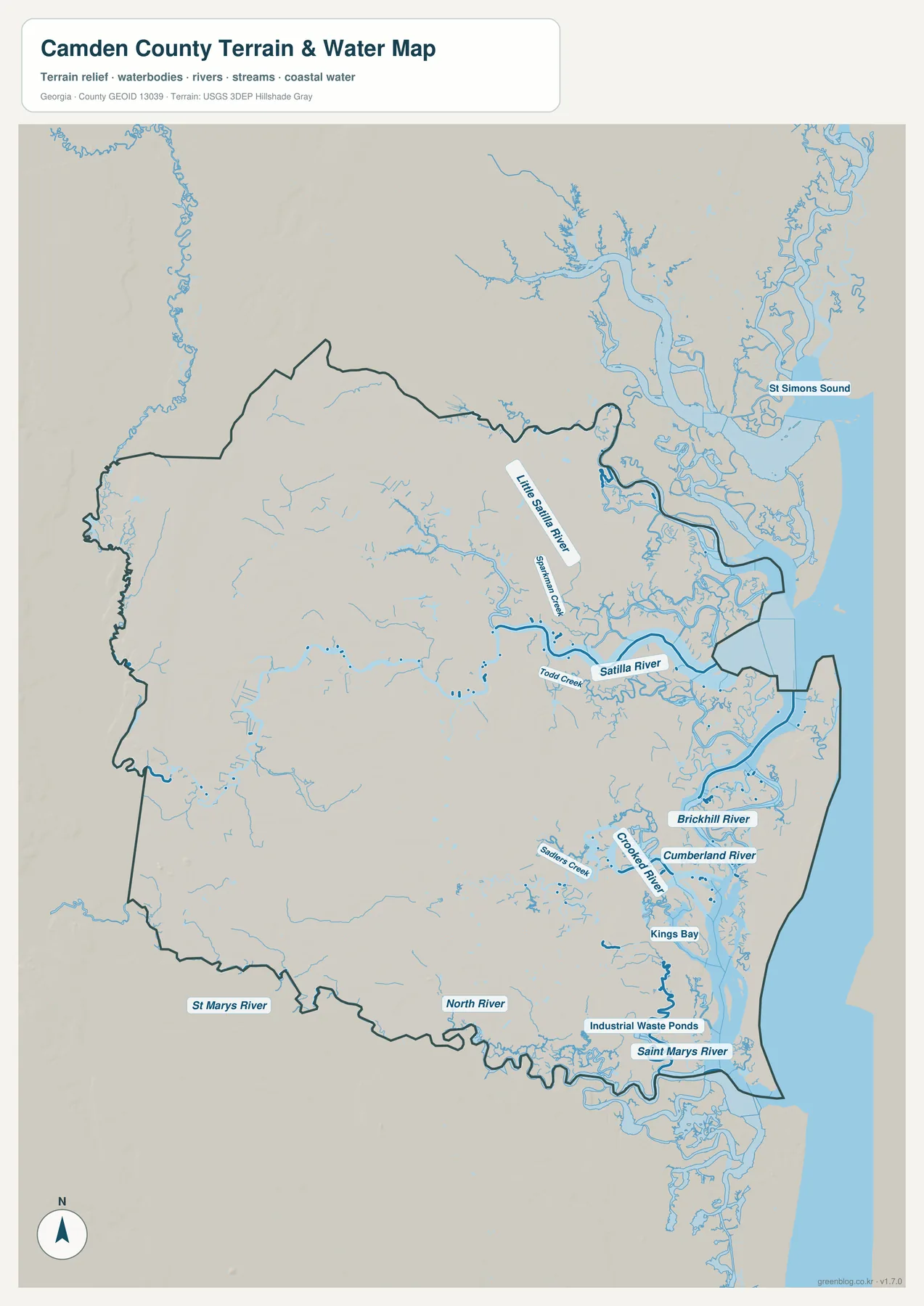
Water is not a minor background feature in Camden; it shapes a large part of the county’s outline and internal geography. The Satilla River crosses the northern and east-central part of the map, with the Little Satilla River farther north and smaller streams such as Todd Creek and Shepherd Creek feeding the broader system. South and east of that river, the map becomes increasingly intricate as channels split through marshland and approach the coast.
Around the southeastern side, Brickhill River, Crooked River, Cumberland River, Sanders Creek, Kings Bay, North River, and the St. Marys River are labeled in a relatively small area. This is why the shoreline cannot be understood as one clean line. The mainland, marshes, islands, and tidal channels interlock, and the St. Marys River forms the state boundary along the south before meeting the coastal waters. The map also places Cumberland Island beyond those tidal channels, visually explaining why a road trip to St. Marys and a trip onward to the island are two different stages of travel.
National Park Service information in the supplied source catalog identifies St. Marys as the mainland departure point for Cumberland Island access by passenger ferry or private boat. There is no ordinary road bridge that turns the island into a continuation of the county highway network. That access detail is useful geographically because it matches what the water map shows: the space between city and island is a broad estuarine environment. Visitors should still check the current park schedule and access rules rather than using a static map as a live transportation guide.
This water map is an orientation reference, not a navigation or flood product. It does not provide channel depth, tidal stage, flood-zone boundaries, evacuation instructions, or parcel-level wetland determinations. Boating, flood safety, and land-use decisions require current specialized information from the responsible agencies. Here, the value is in seeing where the named rivers and creeks sit relative to cities, roads, county limits, and the Atlantic coast.
A very low Coastal Plain with higher ground toward the west
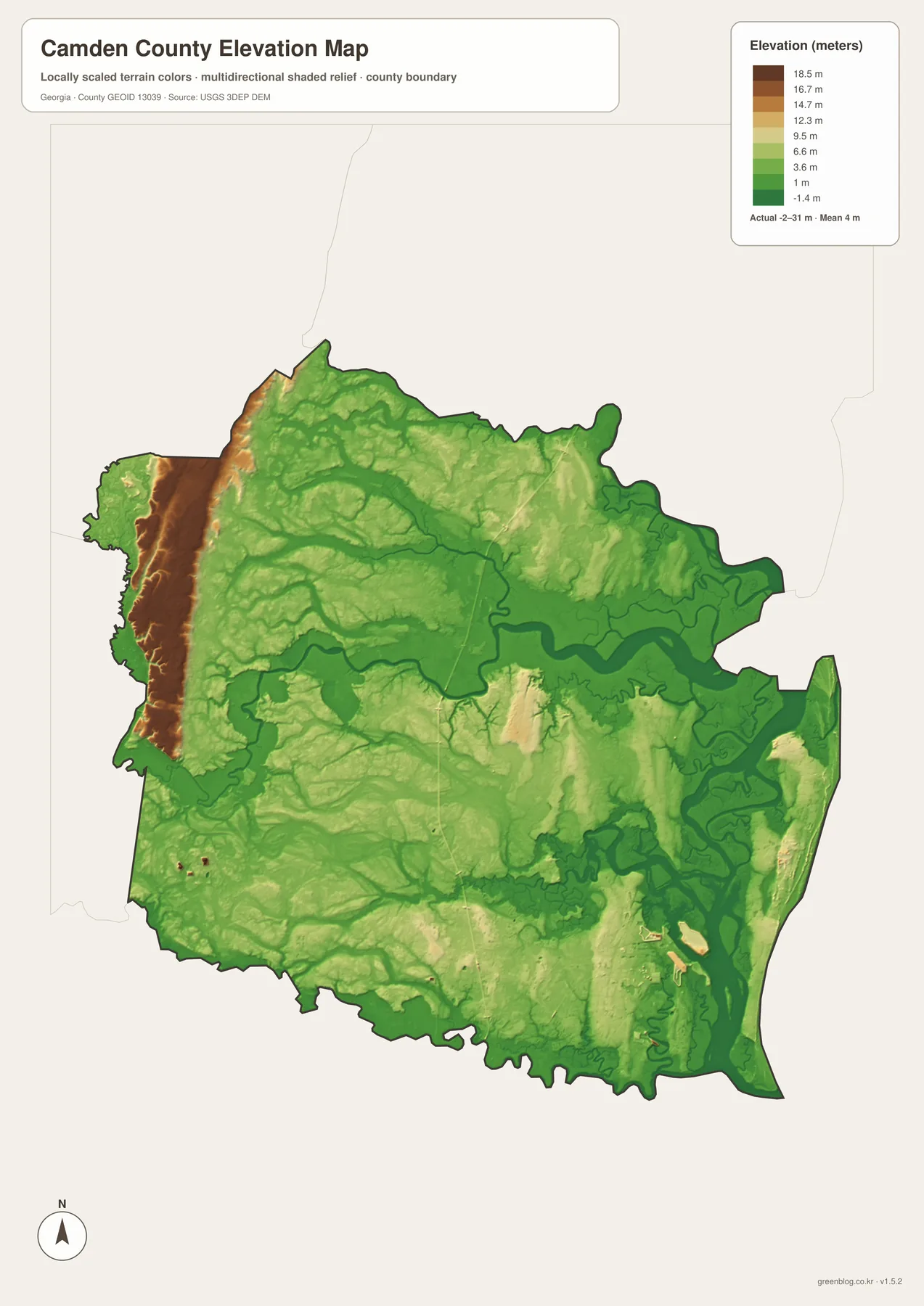
The elevation map makes Camden’s coastal setting especially clear. Its legend reports an actual range of roughly -2 to 31 meters and a mean near 4 meters. Most of the county is shown in green tones associated with low elevation, and the lowest-looking bands closely follow major rivers and tidal areas. Higher brown and tan colors are concentrated mainly along the western side, with smaller raised patches elsewhere. The result is not a mountain-and-valley landscape but a subtle pattern of low wetlands, drainage corridors, and slightly higher inland ground.
Comparing this surface with the water map helps explain the shape of the county. The Satilla corridor and the southeastern marsh-and-river network occupy broad low zones, while the western interior rises enough to stand out even though the total relief remains modest. In a county where the mean elevation is only a few meters, a change of several meters can influence where marsh, drainage channels, roads, and developed land appear. The map does not prove a cause for every road or settlement location, but it gives useful terrain context for features visible on the other maps.
The colors are locally scaled for Camden and should not be compared directly with the same color on a different county map. The surface is also generalized; it is not a survey-grade elevation model for a house lot, construction project, drainage design, or engineering decision. Use it for county-level terrain orientation and pair it with detailed official elevation or survey data whenever exact measurements are required.
Why inland travel and coastal access feel different in Camden
Kingsland and St. Marys are close enough to appear as one southern cluster on a statewide map, yet their geographic settings are distinct. Kingsland is tied directly to the I-95 corridor, giving it an inland north–south orientation toward Brunswick and Florida. St. Marys lies to the east near the river and tidal coast, where travel becomes more dependent on a smaller set of roads and, for Cumberland Island, water transportation. Woodbine adds a third pattern: it is the governmental center farther north near the Satilla River rather than part of the main southern cluster.
Naval Submarine Base Kings Bay is another important feature of the southeastern county. The supplied Navy source describes an installation of about 16,000 acres, including roughly 4,000 acres of protected wetlands. At county scale, that helps explain why a large named federal facility appears among cities and marshes around Kings Bay. The map should only be used to understand its general location; access rules, operational details, and restricted areas must come from current official Navy information.
Cumberland Island forms the most prominent barrier-island setting on Camden’s Atlantic side. National Park Service material describes the island as part of Cumberland Island National Seashore and emphasizes its maritime forest, marsh, and long undeveloped beach. On the maps, the island helps define the eastern edge of the county, while the channels between it and the mainland explain the importance of St. Marys as a departure point. This is a good example of why the boundary, water, and city maps tell a more complete story together than any one of them can alone.
Choosing the right Camden County map for the task
For a first look, start with the county map and find Woodbine, Kingsland, St. Marys, and I-95. If your question is simply how the three main cities relate to each other, the city-connections map removes most other detail and makes direction easy to compare. Use the water map when the subject is the Satilla or St. Marys river systems, Kings Bay, Cumberland Island, or the complicated tidal edge. Add the elevation map when you want to understand why so much of the coastal side is low and how the western interior differs.
- For classroom use, mark Georgia’s southeastern corner, the Florida boundary, the Satilla River, the St. Marys River, and Cumberland Island in sequence.
- For Cumberland Island planning, locate St. Marys on the county map and then use current National Park Service information for ferry times and access conditions.
- For road orientation, use I-95 and Kingsland as the main inland reference, then compare the directions to Woodbine and St. Marys.
- For river or marsh research, use the water map to identify named features before moving to current hydrography, flood, or environmental datasets.
- For printing or offline work, use the four A3 JPG files in the ZIP rather than relying on the lighter WEBP previews embedded in the page.
These maps are best treated as complementary references. The county map gives context, the city diagram reduces the settlement pattern to a few clear relationships, the water map restores the complexity of the coast, and the elevation layer explains how low the region is. None of them replaces current navigation, flood, property, or restricted-access information, but together they provide a practical geographic introduction to Camden County.
Frequently Asked Questions
Is Kingsland the county seat of Camden County?
No. Woodbine is the county seat. Kingsland is the larger interstate-oriented hub on the southern side, while St. Marys is the riverfront and coastal gateway farther east.
Can I drive directly from St. Marys to Cumberland Island?
No ordinary road bridge connects the mainland road network to the island. Visitor access is by passenger ferry or private boat, and current schedules or rules should be checked with the National Park Service before a trip.
Is Camden County mostly flat?
Yes, at county scale it is a very low Coastal Plain landscape. The supplied elevation map reports a mean near 4 meters, with the lowest broad areas around rivers and tidal marshes and comparatively higher ground toward the west.
Map File Information
Camden County A3 map files
- Included Files: 4 high-resolution A3 JPG map files shown in this article
- File Type: JPG files in a ZIP archive
- Intended Use: Printing, education, presentations, and map-based projects
Related Maps
Sources and reference material
- U.S. Census Bureau QuickFacts: Camden County population and land area
- Camden County government: history, cities, and rivers
- National Park Service: Cumberland Island National Seashore
- U.S. Navy: Kings Bay installation facts
- USGS 3D Elevation Program
This page is a static county map reference. Population estimates, ferry service, road restrictions, flood conditions, and federal installation access can change, so time-sensitive decisions should always use the latest information from the responsible agency.
Green Map creates custom-edited map images using open geographic data sources such as geoBoundaries, Natural Earth, OpenStreetMap, and government open data. These maps are edited visual materials, not raw data files, and are provided for education, documents, presentations, and graphic reference.