Barrow County is a compact Piedmont county in northeastern Georgia, positioned between the eastern edge of metro Atlanta and the Athens area. Winder sits near the center, while Auburn and Carl lie toward the western side, Statham marks the east, and Bethlehem is south of the county seat near the Route 316 corridor. Because roads, towns, streams, and terrain are all important here, this page separates those subjects into four maps instead of forcing every detail onto one crowded image.
The map files are available as a single download. The ZIP contains four A3 high-resolution JPGs: a county map, city map, water map, and elevation map. The WebP images in the article are lighter previews for browsing, while the JPGs are sized for printing, classroom use, local research notes, and documents. Start with Winder and the road network, then compare the settlement pattern, drainage, and relief to see how the same county changes when each layer is isolated.
Table of Contents
Barrow County in its regional setting
Barrow County was created on July 7, 1914, from parts of Gwinnett, Jackson, and Walton counties. The existing county material identifies Winder as both the county seat and largest city. It lists a 2020 census population of 83,505, a July 1, 2025 estimate of 99,773, 161.04 square miles of land, and FIPS code 13013. Those figures help explain why the county can feel busy despite its small footprint: towns, highways, and newer development are packed into a relatively short distance.
| State | Georgia |
|---|---|
| County seat and largest city | Winder |
| Created | July 7, 1914 |
| 2020 population | 83,505 |
| 2025 population estimate | 99,773 |
| Land area | 161.04 square miles |
| FIPS code | 13013 |
| Download package | Four A3 JPG maps in one ZIP |
The county is bordered by Gwinnett to the west, Hall to the north, Jackson to the northeast and east, Clarke and Oconee to the southeast, and Walton to the south. That location gives Barrow two obvious regional directions. Westbound travel leads into the Atlanta suburban network, while the eastern side faces the Athens area. The county is therefore easier to understand as a connection zone between two larger activity centers than as an isolated rural county.
The county’s history also reinforces that multi-directional character. The source material notes that Barrow was assembled from three neighboring counties and named for David C. Barrow Jr., who served as chancellor of the University of Georgia. Winder predates the county itself: the settlement was once known as Jug Tavern and took the Winder name in 1893 in honor of railroad executive John H. Winder. Those older transport and administrative roles now sit beside modern highway growth along the southern side of the county.
Winder and the road network on the county map
The general county map makes Winder the clearest reference point. Auburn and Carl appear to the west, Statham to the east, Bethlehem to the south, and a portion of Braselton near the narrow northern end. Outside the boundary, labels such as Hoschton, Arcade, Bogart, Dacula, and Mulberry help orient the county against surrounding places. This wider context is useful because Barrow’s municipal and travel relationships do not stop neatly at the county line.
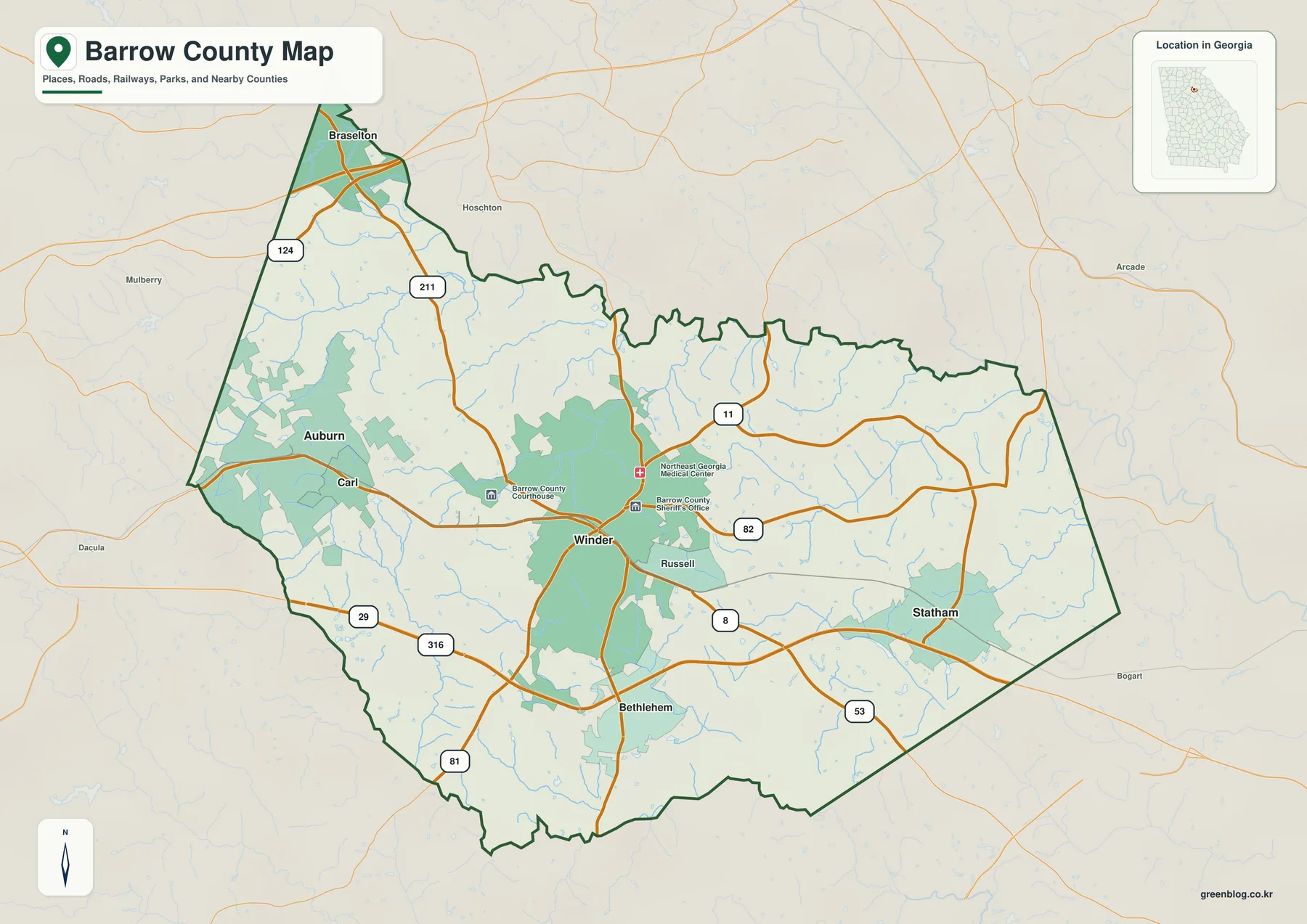
Route 316 is the most conspicuous east–west travel line through southern Barrow. The existing article describes it together with U.S. 29 as the principal connection between the Lawrenceville side of metro Atlanta and Athens. Route 11 runs through Winder in a north–south direction, Route 53 approaches from the southeast, Route 81 crosses the southwest, Route 211 reaches northward, and Route 124 appears in the northwest. Routes 8 and 82 also cross the Winder–Statham side of the county. The map is not a turn-by-turn navigation product, but it clearly shows how multiple roads converge around the county seat and then fan out toward neighboring counties.
This pattern helps separate the county’s administrative center from its major growth corridors. Winder contains the courthouse, sheriff’s office, medical facilities, and the older town center shown on the map. Farther south, Route 316 passes near Bethlehem and carries much of the Atlanta–Athens through movement. The western side around Auburn is tied closely to Gwinnett County, while Statham provides an eastern marker toward Athens. Reading those places together explains more than a simple list of road numbers.
The town pattern is compact but uneven
The city map strips away most of the visual competition and emphasizes five labeled places: Winder, Auburn, Statham, Bethlehem, and Carl. Its city index prints Winder at 19,437, Auburn at 8,711, Statham at 3,018, Bethlehem at 707, and Carl at 183. Those values are best treated as the figures used in the map’s city index rather than as a substitute for a dated census table. For orientation, the more important information is where the five places sit within the county.
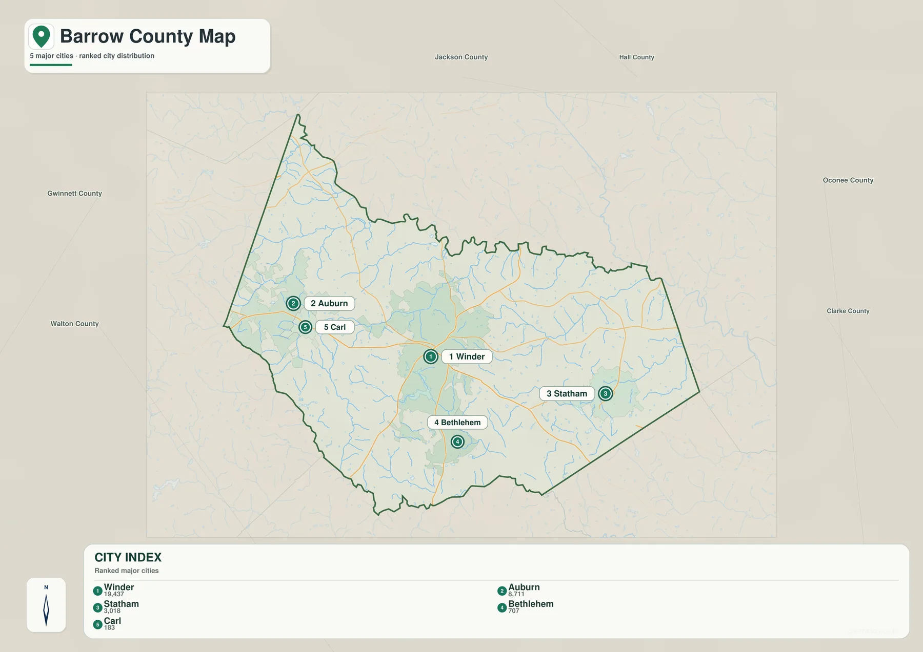
Winder is close to the middle of the county, making it a practical anchor for understanding direction. Auburn and Carl sit near the western edge, Statham is on the eastern side, and Bethlehem is south of Winder. The pattern is useful for a county this small because short distances can make place names seem interchangeable on a regional map. The simplified city map shows that they occupy distinct parts of the county even when the road network is hidden.
Municipal names also require care at county boundaries. The existing material notes that Auburn extends into Gwinnett County, while Braselton has territory in Hall, Jackson, and Gwinnett counties in addition to Barrow. A town label therefore cannot prove which county contains a particular address or parcel. For jurisdiction, zoning, or property work, use the county GIS or the appropriate local government boundary layer. The city map is meant for relative location, not legal boundary decisions.
Rivers, creeks, reservoirs, and small lakes
The water map changes the appearance of Barrow County completely. Instead of highways and town labels, a dense branching network of streams fills the county. Little Mulberry River is labeled in the northwest, while Middle Oconee River and Mulberry River appear toward the northeast and east. Rocky Creek, Cedar Creek, Beech Creek, Williamson Creek, and Marbury Creek add smaller named channels. Along the southern boundary, the Apalachee River provides another strong reference line.
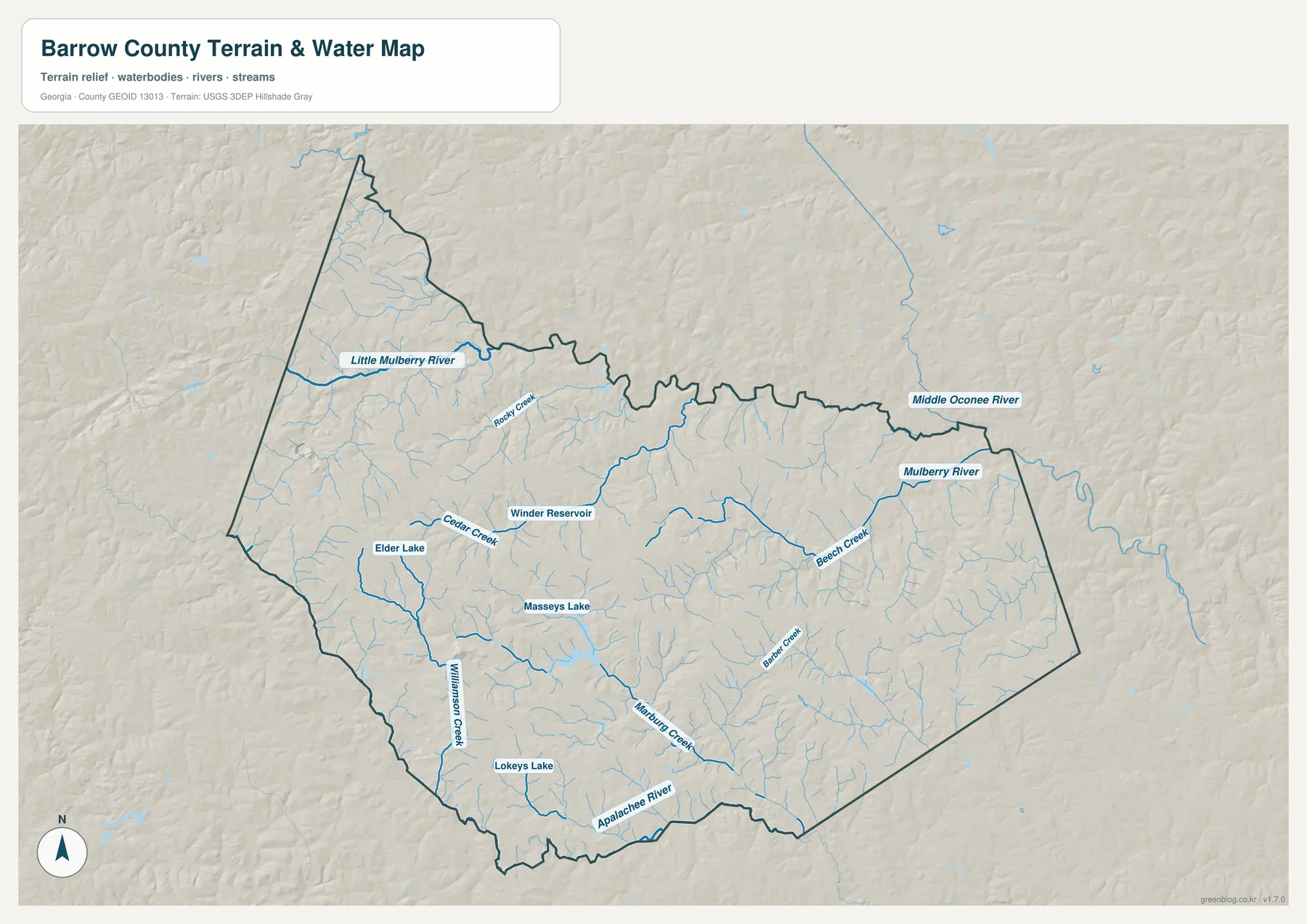
Several named water bodies appear within the county, including Winder Reservoir, Elder Lake, Masseys Lake, and Lokeys Lake. The existing county material also describes Fort Yargo’s 260-acre lake, known as Marbury Creek Reservoir, and notes that Barrow’s public water system is linked to reservoir infrastructure beyond the county line as well. That is a useful reminder that water geography and utility geography are not the same thing as county boundaries.
The map is especially useful when paired with the elevation image. The smaller streams occupy low ground between repeated ridges, so the drainage pattern explains why the shaded relief looks finely cut rather than smooth. A road map can make two nearby places seem separated only by distance; the water map reveals the creeks and valleys between them. It should not, however, be used as a flood-zone map, depth chart, or water-service boundary.
Relief from about 203 to 351 meters
The elevation map reports an actual county range of about 203 to 351 meters, with a mean near 265 meters. The shaded relief shows higher brown and tan ridges concentrated especially along the western and northwestern side, while lower green terrain is more widespread toward the east and northeast. Central and southern Barrow contain a mix of both, producing the rolling Piedmont surface that is easy to miss on a conventional road map.
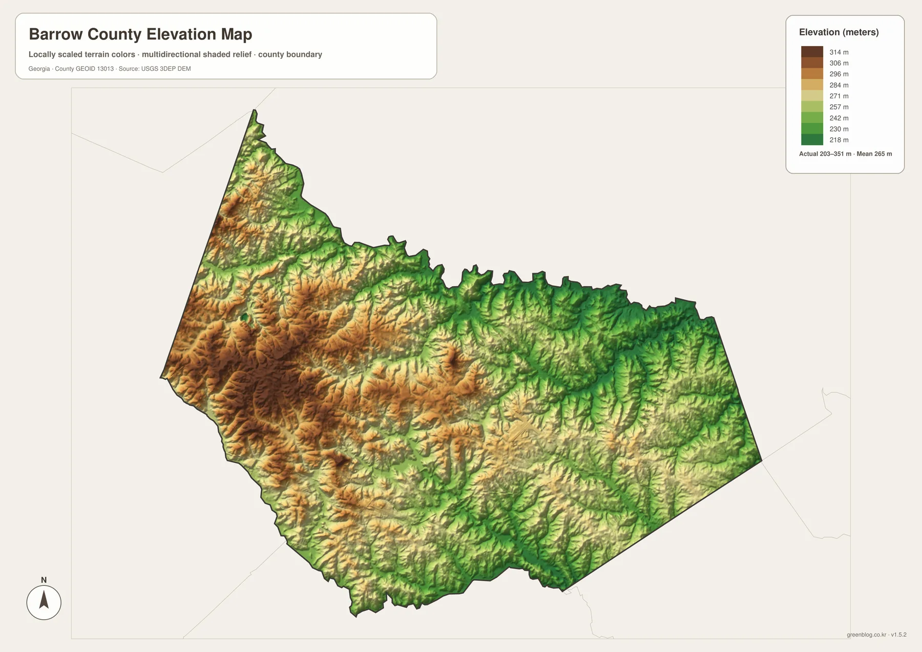
The difference is modest compared with mountain counties, but it is large enough to shape local drainage. Narrow ridges divide small catchments, and stream valleys cut through the lower green areas. When the elevation and water maps are compared, the branching creeks fit naturally into those valleys. The result is a county that is not dramatically mountainous yet is far from flat.
Fort Yargo State Park gives this terrain a familiar local example. The source material lists the park at 1,816 acres with a 260-acre lake and about 20.5 miles of walking and mountain-bike trails. The countywide elevation map cannot provide the grade of a specific trail, but it does show the rolling setting around Winder and the southern part of the county. For engineering, surveying, parcel elevation, or precise slope analysis, use the underlying elevation data or a professional survey rather than this overview.
Choosing the right Barrow County map
Use the county map when the question involves Winder, neighboring towns, major roads, or the county boundary. It is the most complete orientation image because it keeps transportation and place names together. The city map works better when a presentation needs only the relative positions of Winder, Auburn, Statham, Bethlehem, and Carl without a dense road network.
Choose the water map for Little Mulberry River, Winder Reservoir, the Apalachee River, and the network of smaller creeks. Choose the elevation map when the subject is rolling terrain, ridges, valleys, or the county’s roughly 203–351 meter relief. Keeping these subjects in separate files makes the information easier to read and also lets you combine only the maps needed for a lesson, report, or local reference.
- County boundary, Winder, and main routes: county map
- Five highlighted towns and their relative positions: city map
- Rivers, reservoirs, lakes, and creeks: water map
- Ridges, valleys, and countywide elevation differences: elevation map
These maps are countywide reference graphics rather than legal or engineering documents. They do not establish parcel ownership, municipal limits, school attendance zones, zoning, flood risk, or live road conditions. If a decision depends on one of those subjects, follow the overview with the relevant county, state, or federal source. That extra step is particularly important for municipalities that cross county lines.
Frequently Asked Questions
What is included in the Barrow County map ZIP?
The ZIP contains four A3 high-resolution JPG files covering the county and roads, towns, waterways, and elevation. The WebP images on the page are smaller previews, while the JPGs are intended for saving, printing, and document use.
Where is Winder within Barrow County?
Winder is near the center of the county and serves as the county seat. It works as a useful reference point for comparing Auburn and Carl to the west, Statham to the east, and Bethlehem to the south.
How much elevation change does the county map show?
The elevation preview reports a range of roughly 203 to 351 meters and a mean near 265 meters. Higher ridges are more common in the west and northwest, while lower valleys spread toward the east.
Map File Information
Barrow County Map Files
- Included Files: General county, city, water, and elevation maps
- File Type: Four high-resolution A3 JPG files bundled in one ZIP archive
- Intended Use: Printing, education, presentations, and map-based projects
Related Maps
Sources and references
- U.S. Census Bureau QuickFacts – population, land area, and FIPS information
- New Georgia Encyclopedia – Barrow County formation and local history
- Georgia Department of Community Affairs – county and municipal comprehensive plans
- Georgia State Parks – Fort Yargo acreage, lake, and trails
- Barrow County Water Resources – reservoir and utility-system context
Green Map creates custom-edited map images using open geographic data sources such as geoBoundaries, Natural Earth, OpenStreetMap, and government open data. These maps are edited visual materials, not raw data files, and are provided for education, documents, presentations, and graphic reference.