Ben Hill County sits in south-central Georgia, with Fitzgerald serving as the clear center for local roads, services, and county administration. The maps on this page show more than a county outline: they place Fitzgerald within the road network, show how the county relates to nearby counties, trace a dense pattern of creeks and ponds, and reveal modest but visible changes in elevation. You can review each map on the page and download a ZIP containing four high-resolution A3 JPG files for printing or offline reference.
Fitzgerald is the best starting point for reading the county because the settlement pattern is not built around several equally prominent cities. Once Fitzgerald is located, the main road corridors, eastern and northern water networks, and lower terrain along the northeastern side become easier to understand. The county map, city map, water map, and elevation map use the same basic boundary, but each one answers a different practical question without requiring the reader to interpret a complicated GIS display.
Table of Contents
Ben Hill County Location and Quick Facts
Ben Hill County is part of Georgia’s south-central Coastal Plain, and Fitzgerald is the county seat. The county was created in 1906 and named for Benjamin Harvey Hill, a Georgia political figure who also served in the U.S. Senate. Fitzgerald predates the county and grew from a planned settlement established in the 1890s. That history helps explain why the county’s administrative geography is so strongly focused on one city rather than divided among several incorporated places.
| State | Georgia |
|---|---|
| County | Ben Hill County |
| County seat | Fitzgerald |
| Created | 1906 |
| 2020 census population | 17,194 |
| 2025 population estimate | 17,099 |
| Land area | About 250.12 square miles |
| FIPS code | 13017 |
| Download package | Four high-resolution A3 JPG maps in one ZIP |
The U.S. Census Bureau reported 17,194 residents in the 2020 census and a July 2025 estimate of 17,099. Those figures are close, but they come from different statistical series, so the date and type of estimate should stay attached when the numbers are reused. For map reading, the more important point is the settlement pattern: Fitzgerald concentrates much of the visible urban footprint, while a large share of the county outside the city remains rural and is crossed by roads, creeks, and smaller named communities.
County Map: Fitzgerald, Roads, and Boundaries
The general county map gives the fastest overview of Ben Hill’s shape and road layout. Fitzgerald appears near the lower central part of the county, with major routes meeting in and around the city. U.S. 129 and U.S. 319 are prominent north-south and diagonal connections, while routes numbered 90, 107, 11, 125, 182, and 206 extend toward different parts of the county and neighboring areas. This makes Fitzgerald easy to use as an orientation point even before a reader knows the smaller local roads.
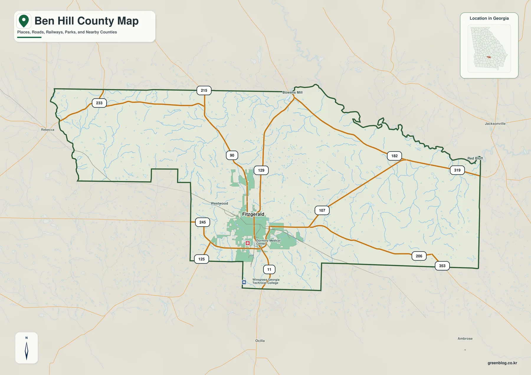
Several smaller labels add useful context around the main city. Bowens Mill appears near the northern side, Westwood is labeled just west of Fitzgerald, and Red Bluff appears toward the eastern side. The map also marks local facilities such as Dorminy Medical Center and Wiregrass Georgia Technical College. These details help show that the area outside the main city label is not empty; settlement and services continue along the road network even when every community is not shown.
The county outline has a distinctive stepped shape on the west and southwest, while the eastern half spreads more broadly before narrowing along the northeastern edge. Learning that outline is useful because it becomes the reference frame for the other three maps. The general map should not be treated as a parcel, zoning, school-district, or turn-by-turn navigation map. It is best for county-scale orientation, locating Fitzgerald, and seeing how the main roads leave the city in different directions.
City Map: Why Fitzgerald Dominates the Settlement View
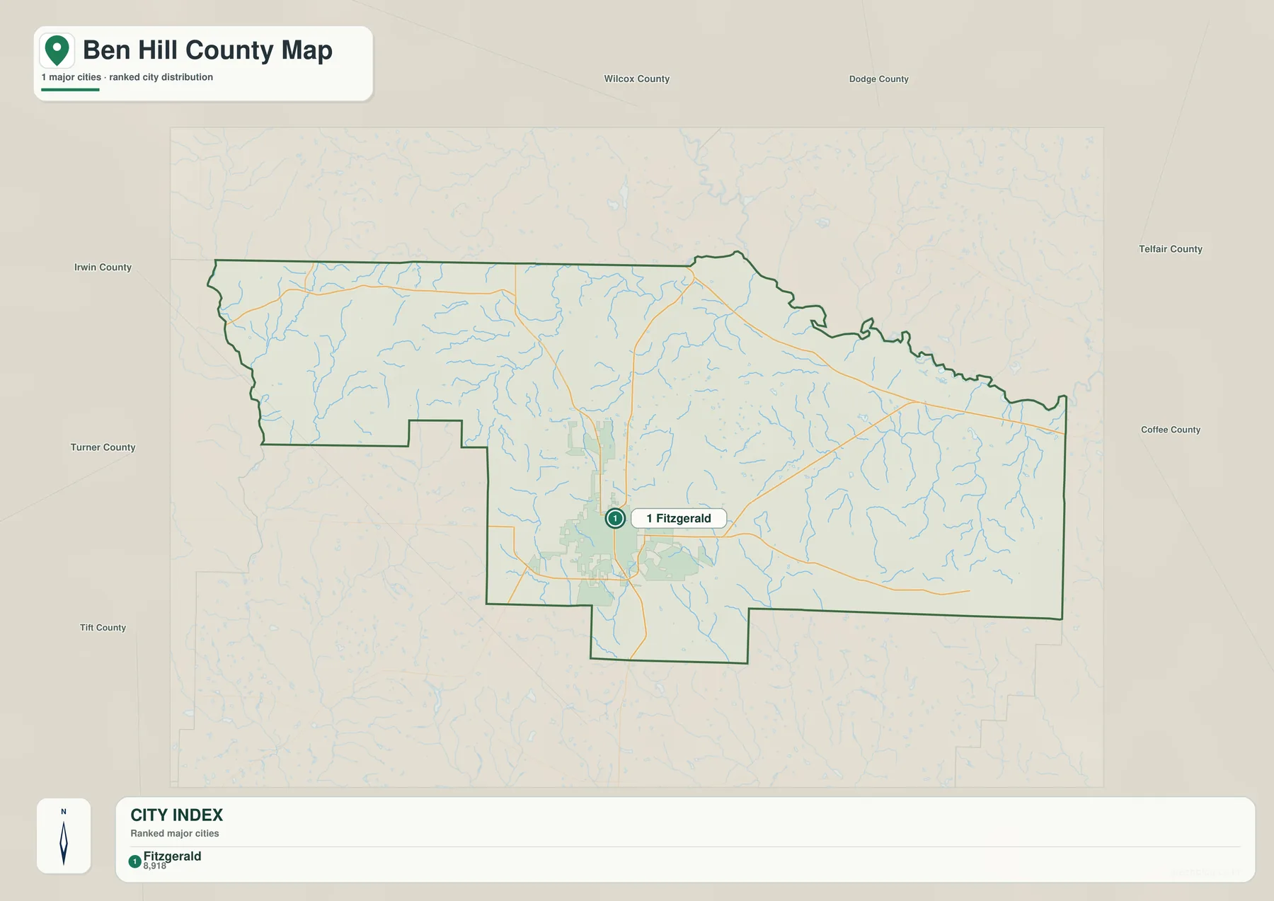
The city map is intentionally simple. Fitzgerald is the only major city ranked within Ben Hill County on this graphic, so there are no multi-city connector lines to compare. Instead, the map is useful for seeing how one urban center sits inside a mostly rural county. Neighboring county labels around the outside provide direction: Wilcox lies to the north, Telfair to the northeast, Coffee to the east, Irwin to the south, and Turner to the west. Additional regional labels farther outside the boundary help place Ben Hill within the wider South Georgia landscape.
Fitzgerald’s importance also has a historical explanation. The New Georgia Encyclopedia and the City of Fitzgerald describe a settlement founded in the 1890s as a planned colony associated with Civil War veterans. The city later developed as a rail and service center, and it became the seat when Ben Hill County was formed in 1906. That background is useful because the map’s single-city emphasis reflects a real administrative pattern rather than a design shortcut.
For practical use, the city map works well in travel planning, school assignments, county comparison pages, or any project that needs a clean answer to “Where is Fitzgerald within Ben Hill County?” It does not show every unincorporated community or local neighborhood. A missing place name should therefore not be read as evidence that the place does not exist or has no local importance; the graphic is simply selective about which settlements receive a city ranking.
Water Map: Creeks, Ponds, and Low Ground
The water map changes the character of the county immediately. Instead of roads taking visual priority, dozens of small blue channels spread across the boundary. This is not a county dominated by one large lake. Its water geography is better understood as a network of creeks, branches, and small ponds that cross farm and woodland areas. On the western side, Willis Creek is labeled. Little House Creek and Otter Creek appear farther north and toward the center, while the eastern half includes names such as Sherman Creek, Sutton Creek, Little Sturgeon Creek, and Red Bluff Creek.
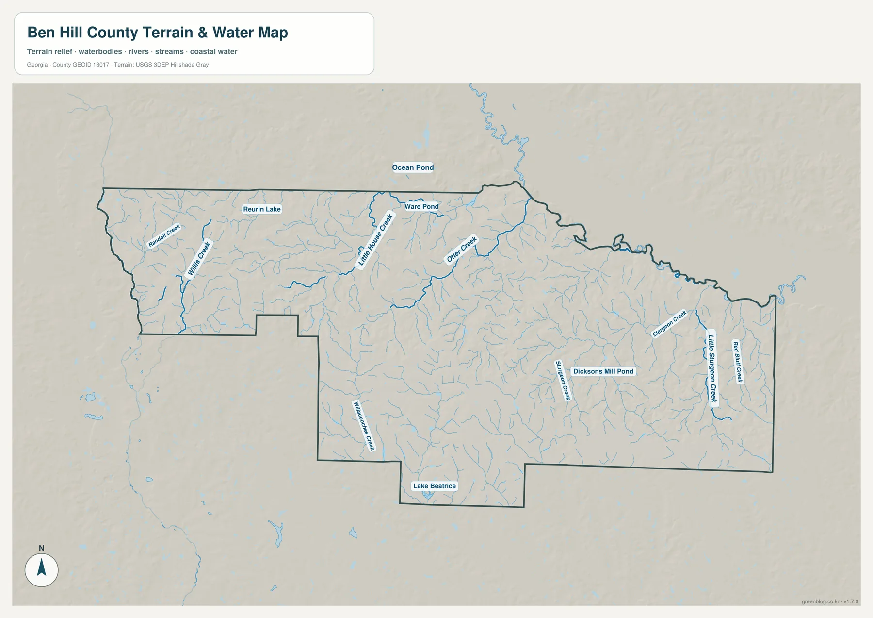
Several small water bodies are labeled as well. Ware Pond appears near the northern part of the county, Dicksons Mill Pond is marked in the eastern half, and Lake Beatrice is shown near the southern boundary. Ocean Pond appears just beyond the northern edge, which is helpful for understanding the landscape immediately outside the county rather than stopping every feature at the administrative line. The density of smaller streams is especially noticeable east of Fitzgerald, where many tributaries branch through the county.
This map is designed for geographic reference, not flood prediction or navigation. A blue line identifies a mapped water feature, but it does not tell the reader the current depth, discharge, legal access, flood frequency, or whether a boat can use that channel. Anyone making a property, emergency, fishing-access, or construction decision should use the appropriate current agency data. For ordinary map use, however, the water layer is excellent for understanding why the countryside contains so many narrow low areas even though the county looks broadly flat on a road map.
Elevation Map: A Gentle Slope across Ben Hill County
Ben Hill County is not mountainous, but the elevation map shows enough relief to explain some of the drainage pattern. The map legend gives an actual elevation range of about 40 to 123 meters, with a mean near 87 meters. Browns and tan shades are more common across the western and southwestern portions, indicating comparatively higher ground. Greens become more prominent toward the northeastern boundary and along lower drainage areas, where the terrain drops closer to the low end of the local range.
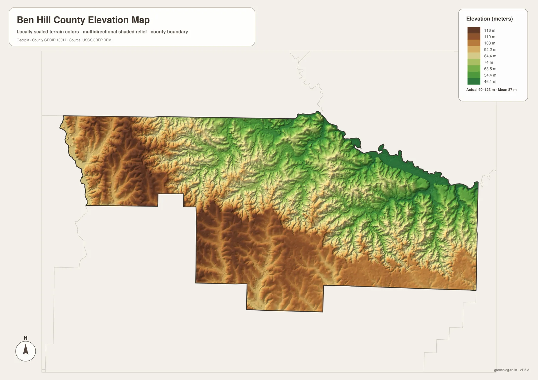
The shaded relief also reveals small ridges and shallow valleys that are difficult to notice on the simpler county map. None of these features approaches mountain-scale relief, but together they guide the many short creeks toward lower ground. Comparing the elevation map with the water map is therefore more informative than reading either one alone. The western side contains broader areas of relatively higher color, while the northeastern side includes lower green corridors that correspond well with the concentration of drainage features.
The surface is generalized for county-wide viewing. It should not be used as a survey, engineering profile, building-site elevation, or drainage-design measurement. A single color band covers a range of heights, and the shaded texture emphasizes terrain shape rather than a precise elevation at every pixel. For classroom geography, travel orientation, watershed discussion, or a quick comparison of high and low parts of the county, that generalization is useful because it makes subtle South Georgia relief easier to see.
How the Four Maps Work Together
The four files are most useful as a set because each map removes some detail in order to emphasize something else. The county overview gives roads, the county boundary, selected places, and facilities in one frame. The city map strips the settlement picture down to Fitzgerald and its regional position. The water map shifts attention to creeks and ponds, and the elevation map explains the gentle high-to-low terrain that helps organize those waterways. Because the county outline remains recognizable, it is easy to move from one map to another without losing your place.
A simple example is the eastern half of Ben Hill County. On the county map, routes such as 107, 182, 319, and 206 provide the most obvious structure. On the water map, the same area is filled with branching streams, including Sherman Creek and other named channels. The elevation map then shows lower green terrain toward the northeastern edge and slightly higher ground farther south and west. Reading the three views in sequence turns what first looks like a road corridor into a more complete picture of transportation, drainage, and terrain.
The same approach works for Fitzgerald. Start with the general map to see the roads entering the city. Switch to the city map to understand its role as the county’s principal urban center. Then compare nearby creeks on the water map and the local elevation colors on the terrain map. This method is useful for students, travelers, local-history readers, and anyone preparing a simple county reference page because it builds understanding from familiar landmarks before moving to natural features.
- Use the county map for boundary shape, Fitzgerald, road numbers, and selected local places.
- Use the city map for a clean view of Fitzgerald’s position relative to neighboring counties.
- Use the water map when named creeks, ponds, and drainage features matter most.
- Use the elevation map to compare the higher west and southwest with lower northeastern terrain.
- Use official parcel, flood, transportation, or survey systems for decisions that require legal or engineering precision.
Frequently Asked Questions
Why does the city map show Fitzgerald as the only major city?
The city map ranks the principal city shown for this county rather than labeling every settlement and unincorporated community. Fitzgerald is the county seat and the dominant urban center in the supplied city dataset, so it appears alone in the ranked city view. Smaller communities can still be locally important even when they are not included in that map.
Can the water map be used as a flood-risk map?
No. It shows mapped water features and terrain for geographic reference, but it does not define current flood zones, water depth, legal access, or emergency conditions. Flood-related decisions should be checked against current FEMA and local government information.
Is the elevation map accurate enough for surveying or construction?
No. The map is a county-scale visualization that makes relative high and low areas easy to compare. The approximate 40–123 meter range is useful for general geography, but engineering, building, and property work requires the original elevation data or a professional survey.
What is included in the downloadable ZIP?
The package contains four A3 high-resolution JPG files: the general county map, city map, water map, and elevation map. The images displayed in the article are WEBP previews optimized for web viewing, while the ZIP provides the larger original JPG versions for printing and storage.
Map File Information
Ben Hill County A3 map files
- Included Files: General county, city, water, and elevation maps
- File Type: Four high-resolution A3 JPG files bundled in one ZIP archive
- Intended Use: Printing, education, presentations, and map-based projects
Related Maps
Sources for Ben Hill County, Water, and Elevation Data
These references provide background for county statistics, local history, hydrography, and elevation. Publication dates and data vintages vary, so readers using a number or administrative fact in another project should confirm the date shown by the original source.
- U.S. Census Bureau QuickFacts – Ben Hill County, Georgia
- New Georgia Encyclopedia – Ben Hill County
- City of Fitzgerald – City history and Colony City background
- USGS National Hydrography – Water-feature reference
- USGS 3D Elevation Program – Elevation reference
Green Map creates custom-edited map images using open geographic data sources such as geoBoundaries, Natural Earth, OpenStreetMap, and government open data. These maps are edited visual materials, not raw data files, and are provided for education, documents, presentations, and graphic reference.