A New York State County Map has to fit several very different geographic patterns onto one page: the broad western counties beside Lakes Erie and Ontario, the smaller Finger Lakes and central counties, the Adirondack and North Country interior, the narrow Hudson Valley, and the five county-level parts of New York City beside Long Island. This is a statewide county reference rather than a map of one individual county. The supplied landscape layout keeps all 62 county shapes visible without reducing the state to a simple outline.
The package contains a labeled color map, a labeled black-and-white version, and an unlabeled outline. All three published previews measure 1200 × 976 pixels and share the same county geometry. The resources were arranged for A3 landscape use in classroom handouts, state-reference sheets, presentation graphics, labeling exercises, regional comparisons, and custom visual projects.
The distinction between New York State and New York County matters here. New York County is the official county name for Manhattan, but this article and download cover the state’s complete 62-county framework. At the southeastern end of the map, New York County appears alongside Bronx, Kings, Queens, and Richmond counties—the five counties corresponding to New York City’s five boroughs.
Table of Contents
New York State County Map Overview
The western edge begins with Chautauqua, Erie, and Niagara along the Great Lakes, with Cattaraugus and Allegany immediately inland. Orleans, Genesee, Wyoming, Livingston, Monroe, Ontario, Wayne, Yates, Seneca, and Steuben create a denser pattern toward the Finger Lakes. Lake Erie and Lake Ontario are labeled in blue, while several smaller inland water shapes appear without names.
Across central New York, Oswego, Onondaga, Cayuga, Cortland, Tompkins, Schuyler, Chemung, Tioga, Broome, Chenango, Madison, Oneida, and Herkimer form a transition from the lake shore to the Southern Tier and Mohawk Valley. Fulton, Montgomery, Otsego, and Schoharie sit farther east. Their compact boundaries require more attention than the broad rectangular forms along the Pennsylvania line.
The north is dominated by large counties: Jefferson and St. Lawrence face the Canadian border and Lake Ontario, while Franklin, Clinton, Essex, Hamilton, Warren, and Washington extend across the North Country and Adirondack area. Lewis lies between Jefferson, St. Lawrence, Herkimer, and Oswego. The map labels Canada as a country but does not separate or name Ontario and Quebec.
Near the capital region, Saratoga, Schenectady, Albany, Rensselaer, Greene, Columbia, and Schoharie cluster around the upper Hudson corridor. “Albany” is printed as a county name; there is no separate city marker or capital symbol. Farther south, Delaware, Sullivan, Ulster, Dutchess, Orange, Putnam, Rockland, and Westchester narrow toward New York City.
Long Island is divided into Nassau and Suffolk outside New York City. The city itself contributes Bronx County, Kings County for Brooklyn, New York County for Manhattan, Queens County, and Richmond County for Staten Island. The artwork prints the county names rather than the more familiar borough names, which is why Brooklyn and Staten Island do not appear as labels.
Pennsylvania, New Jersey, Connecticut, Massachusetts, and Vermont are labeled for orientation. The map does not show roads, cities, railways, terrain, population, or named rivers, and it is not a route planner. Its purpose is county identification and relative position, with water and surrounding states supplying only enough context to read the outline.
- Statewide coverage: all 62 New York counties
- New York City detail: Bronx, Kings, New York, Queens, and Richmond counties
- Color view: county names with alternating muted fills
- Monochrome view: the same names and boundaries on white interiors
- Outline view: county boundaries without names or fills
Color-Coded County Layout
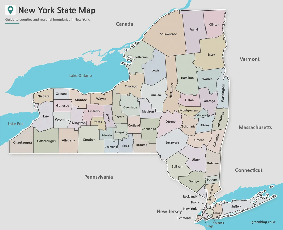
The color edition assigns adjoining counties different pastel fills so boundaries can be followed without relying on line direction alone. This is especially effective around the Finger Lakes, the Albany–Schenectady area, the lower Hudson Valley, and New York City, where several small county shapes meet. Large northern counties remain easy to identify even when the map is reduced.
The fills are categorical only. They do not represent population, political results, climate, tourism regions, economic activity, elevation, land cover, or school districts. When users add a thematic layer, it needs a separate legend and a dated source. Transparent markers or patterns are preferable when the original county separation must remain visible.
This version works well as an introductory slide, wall reference, or labeled answer sheet. The blue Great Lakes and coastal water help distinguish western and southeastern geography, while the gray neighboring areas keep attention on New York. No city points are included, so Buffalo, Rochester, Syracuse, Albany, and New York City should not be inferred from county labels alone.
Black and White New York State County Map
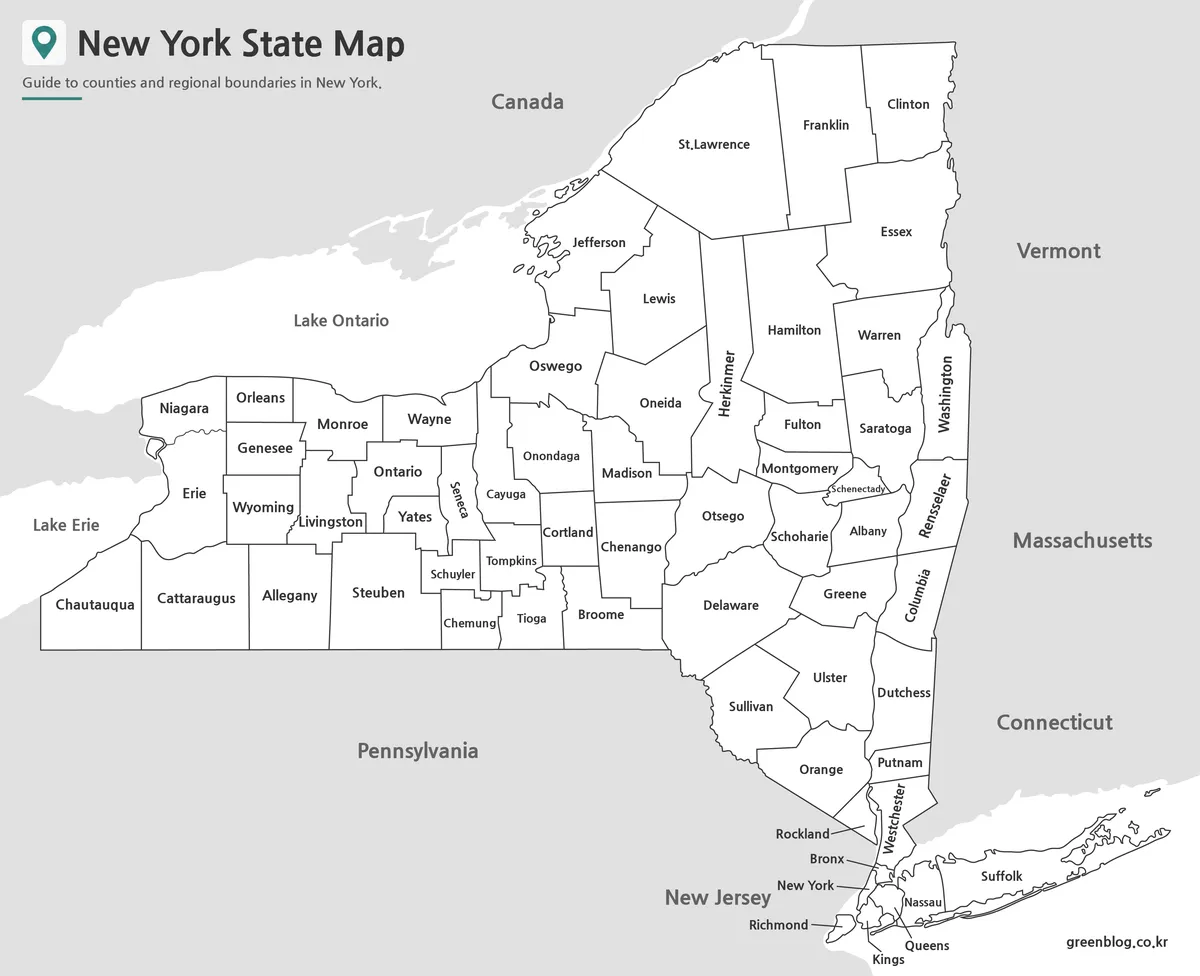
The monochrome edition removes the pastel fills but keeps every county name, the surrounding-state labels, Canada, and the major lake names. White county interiors reduce competition with text and charts, making this view suitable for reports, handouts, and worksheets where readers still need a complete labeled reference.
Because the answers are printed, this is better for guided identification than for a closed-book county quiz. Teachers can pair it with the blank outline as an answer key. Users can also add circles, arrows, short notes, or one highlight color without obscuring the county labels.
Test the southeastern detail before printing multiple copies. Bronx, New York, Kings, Queens, Richmond, Nassau, Rockland, and Putnam occupy small or narrow spaces, and several labels use leader lines or rotated text. Preserve the landscape ratio and leave a margin around Long Island, the Canadian border, and the western lake shore.
Outline Map for Editing Projects
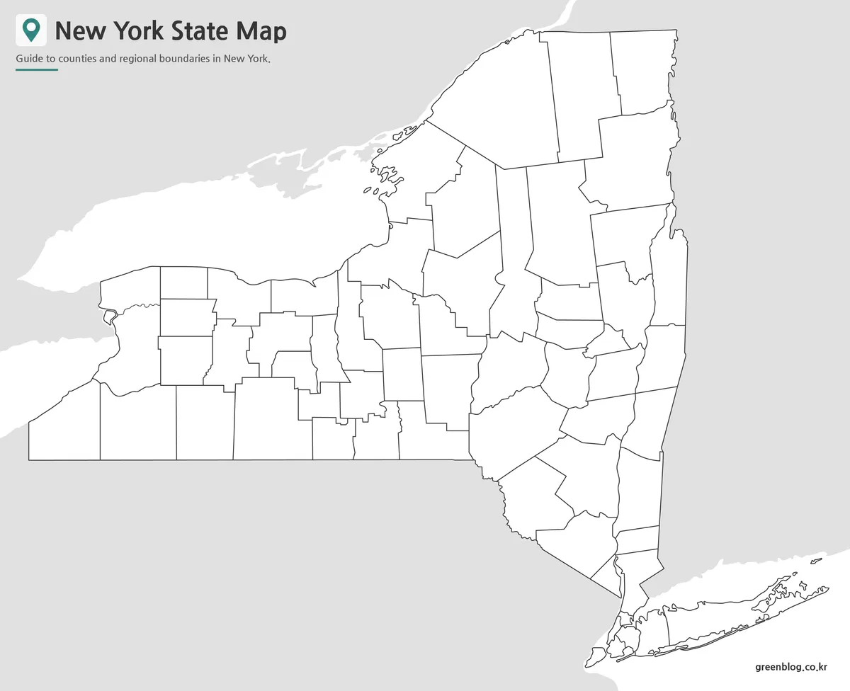
The blank New York State County Map removes county names, neighboring-place labels, lake text, and all color fills while retaining the state silhouette and 62 internal divisions. It provides a neutral base for labeling practice, regional grouping, localized text, simple data displays, and custom annotations without forcing users to erase embedded answers.
A classroom sequence might begin with the color reference, continue with the labeled monochrome view, and finish with the outline. Learners can identify counties bordering Lake Erie or Lake Ontario, trace the Hudson Valley, separate Nassau and Suffolk, or match the five New York City boroughs to their county names.
Designers can add project-specific fills, arrows, markers, and legends, but the resource is a raster image rather than a GIS layer or vector file with selectable county polygons. Keep an untouched copy before editing. The generalized boundaries should not be used for surveying, legal property questions, emergency routing, or parcel-level decisions.
Practical Uses for a New York State County Map
The three-map set is most useful when county position matters more than street or city detail. A state geography lesson can compare western New York with the North Country; a presentation can group Hudson Valley counties; and a New York City lesson can explain why borough names and county names are not always identical.
For an A3 print, use landscape orientation, preserve the aspect ratio, and check the smallest downstate labels before producing a class set. On a presentation slide, show the statewide image first and then enlarge New York City or Long Island in a separate crop if needed. Do not crop those areas from the only copy because they contain seven of the state’s county divisions.
For online publication, pair each image with descriptive alternative text and explain the 62-county scope in visible copy. If population, health, travel, election, weather, or economic information is added, identify the source date and legend. This separates the supplied boundary map from a new thematic layer and prevents decorative colors from being mistaken for data.
Frequently Asked Questions
What does the New York County Map include?
The New York County Map collection includes color, labeled, and outline versions showing all county boundaries across the state.
Can I print the maps in A3 size?
Yes. The files were prepared as high-resolution resources and reviewed for large-format printing.
Is the outline version editable?
Yes. The blank version is intended for annotations, custom coloring, infographic projects, and educational activities.
Are all county boundaries included?
Yes. Every version includes county boundary lines, while labels and colors vary depending on the map style.
Map File Information
The ZIP package groups color, labeled monochrome, and blank outline images using the same 62-county statewide framework.
- Included Versions: Color, labeled black and white, and blank outline
- Printable Size: A3 landscape layout
- File Type: Image files in one ZIP archive
- Intended Use: Lessons, reports, presentations, labeling, coloring, and annotations
Related Maps
Additional Resources
- Counties of New York State — Browse the official New York State directory for all 62 counties and their regional profiles.
Green Map creates custom-edited map images using open geographic data sources such as geoBoundaries, Natural Earth, OpenStreetMap, and government open data. These maps are edited visual materials, not raw data files, and are provided for education, documents, presentations, and graphic reference.