A Vermont Map becomes much easier to read when all 14 counties are separated clearly from Grand Isle in the northwest to Windham in the southeast. This collection provides three portrait-oriented views of the same county framework: a pastel color edition, a labeled monochrome edition, and a blank outline edition. Together they support quick reference, economical printing, and hands-on labeling without forcing one design to serve every task.
The images also show Vermont in regional context. New York is labeled along the west, New Hampshire along the east, and Massachusetts below the southern boundary. Lake Champlain appears as the long water area beside the western edge, although the lake itself is not named. The northern boundary is visible, but Canada and Quebec are not labeled. Reading those inclusions and omissions before using the artwork prevents viewers from assuming that the maps contain cities, roads, or a complete political reference layer.
Use the Vermont Map as a county base rather than as a navigation map. Montpelier, Burlington, Rutland, and other communities are not marked; neither are highways, mountain ranges, rivers, elevations, county seats, or points of interest. The simple geometry is an advantage for lessons and design work because users can add only the information their project needs. Each supplied preview is 1,200 × 1,674 pixels, a tall proportion that fits portrait pages and vertical slides naturally.
Table of Contents
Vermont Map Overview
Vermont is divided into Addison, Bennington, Caledonia, Chittenden, Essex, Franklin, Grand Isle, Lamoille, Orange, Orleans, Rutland, Washington, Windham, and Windsor counties. Those names can be verified in the state law cited below. On the artwork, the northern tier begins with Grand Isle, Franklin, Orleans, and Essex; Chittenden, Lamoille, Washington, and Caledonia occupy the broad north-central area; Addison and Orange sit farther south; and Rutland, Windsor, Bennington, and Windham complete the lower half.
The Vermont Map makes several spatial relationships immediately apparent. Grand Isle is small and detached-looking because its county geography includes islands in Lake Champlain. Essex reaches the far northeastern corner, while Bennington and Windham form the southwestern and southeastern corners. Washington County is central, but the state capital is not plotted. The design therefore helps with county adjacency and relative position, not municipal location.
All three versions repeat the same outer border and internal county lines, so users can switch styles without changing the geography being discussed. Labels sit inside most counties, while the Grand Isle name is placed outside the narrow island area for legibility. Because the canvas contains generous surrounding space, it can also accept a title, legend, scale note, or source credit without covering the county shapes.
Color-Coded County Map
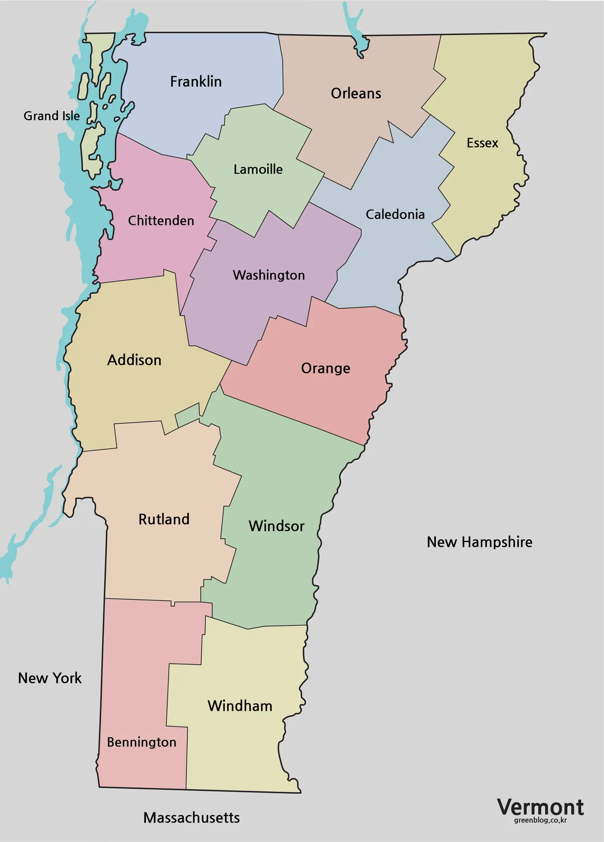
The color Vermont Map is the fastest version for comparing adjacent counties. Alternating pastel fills distinguish small neighbors such as Grand Isle, Franklin, Chittenden, and Lamoille without requiring a heavy thematic legend. It is well suited to an introductory slide, a classroom wall sheet, or a report page where readers need to find a county before examining associated data.
The colors are categorical rather than statistical: they separate boundaries but do not represent population, elevation, voting, climate, or any other measured value. If the map is paired with a data table, add a separate legend and apply a deliberate color scale. Otherwise, readers may mistake the decorative palette for encoded information. The labeled neighboring states are useful orientation cues, while the unlabeled northern neighbor should be added when the full international setting matters.
Black and White Map for Printing
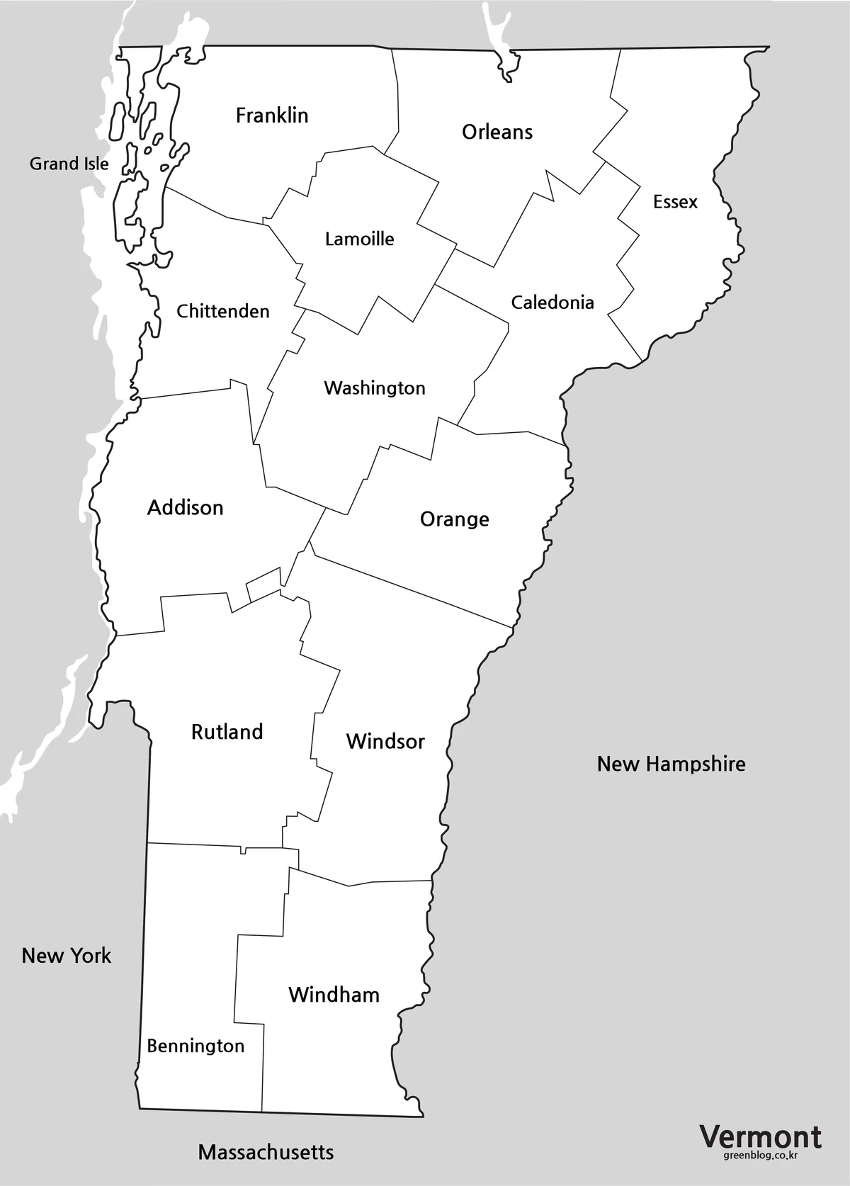
The monochrome Vermont Map preserves every county name while removing the pastel fills. Clear white county interiors leave room for pencil marks, dates, values, symbols, or short notes. It is the most practical choice for photocopied packets, report appendices, meeting handouts, and any situation in which color reproduction may vary between devices or printers.
Before distributing a reduced copy, print one test page and check the smallest labels, especially Grand Isle and Lamoille. A3 provides the intended working area, but the portrait layout can be reduced for ordinary pages if margins are preserved. Avoid stretching it to a different aspect ratio, since distortion can make county shapes look misleading. For grayscale data work, use patterns, numbered markers, or clearly separated gray values instead of several similar tints.
Outline Map for Custom Projects
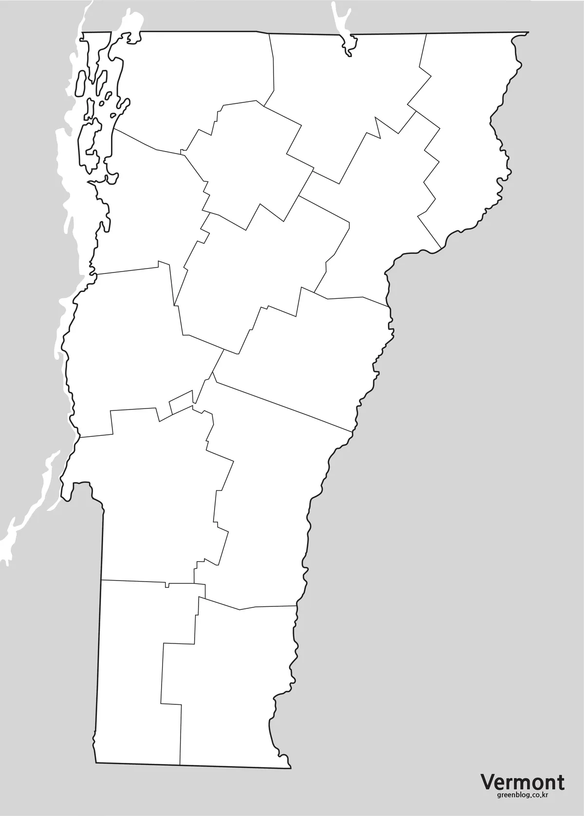
The blank Vermont Map removes county names and interior color while retaining the complete county framework. Students can identify all 14 divisions from memory, color regional groups, or add labels from a word bank. Designers can place custom symbols above the lines, build a county-level comparison, or create a route diagram that remains visually separate from the original artwork.
A useful workflow is to keep one untouched copy as a reference layer and edit a duplicate. Add a concise legend, explain what each mark represents, and cite the source of any overlaid data. If a project needs accurate roads, municipal limits, waterways, or coordinates, obtain those layers from an authoritative geographic source rather than drawing them from this simplified county illustration. The outline is a communication base, not a surveyed boundary dataset.
Practical Uses for the Map Collection
Choose a task before choosing a version. The color sheet supports rapid visual comparison; the monochrome sheet supports reading and note-taking; and the outline sheet supports recall, customization, and original thematic design. This division of roles keeps the map legible and avoids adding layers that do not help the audience.
- County identification: locate a named county, then describe which counties touch it.
- Regional grouping: compare western, central, eastern, northern, and southern county groups.
- Border study: mark the sides facing New York, Massachusetts, New Hampshire, and Quebec.
- Lake Champlain context: highlight counties along or near the visible western water body.
- Data presentation: add sourced county statistics with a clearly defined legend.
- Assessment: use the blank view for a quiz and the labeled view as an answer key.
For a border exercise, ask learners to identify what the artwork shows and what must be supplied separately. They can see three neighboring U.S. states, but they must add Quebec to the north. They can recognize Lake Champlain by shape and position, but the name is absent. This turns the map’s omissions into a source-reading activity rather than allowing them to pass unnoticed.
Choosing the Right Version
Select the color edition when county separation must be obvious at a glance. Select monochrome when the page will be printed repeatedly or annotated by hand. Select the blank outline when the audience should supply names, categories, or routes. A presentation can also use the three in sequence: orientation first, close reading second, and an activity or original analysis last.
Whichever Vermont Map version you choose, state its limitations near the figure. It does not locate cities or county seats, and it does not label the northern international neighbor, Lake Champlain, or the Connecticut River. Do not use it to calculate distance, trace a legal boundary, or navigate. Those tasks require a map with scale, coordinates, and authoritative reference layers.
For digital use, preserve the original aspect ratio and export at a size that keeps labels sharp. For print, use portrait orientation, allow white margins, and avoid placing binding holes over the western edge. When adding information, keep text outside county lines where space is limited and connect it with a short leader line. These small choices improve legibility without altering the underlying county shapes.
Frequently Asked Questions
Can I print the Vermont map in A3 size?
Yes. The layout was prepared with A3 printing in mind and can also be reduced for smaller worksheets or report pages.
Which file formats are included?
The collection is provided in JPG, WEBP, and ZIP formats.
Is the outline version suitable for editing?
Yes. It is designed as a simple base for adding colors, labels, routes, markers, and infographic data.
Does the map show all 14 Vermont counties?
Yes. The collection covers all 14 counties, including Grand Isle County, Chittenden County, Rutland County, and the other county divisions.
What is not included on this Vermont Map?
The three images do not show cities, county seats, roads, routes, mountains, elevation, or named waterways. Canada and Quebec are also not labeled at the northern boundary. Add an authoritative reference layer when a project requires those details.
Download Information
Map File Information
The package contains color, monochrome, and blank county views for reference, printing, and customization.
- Included Versions: Color labeled, black-and-white labeled, and blank outline
Related Maps
Additional Resources
- Vermont Statutes, Title 24, Chapter 1: official county names and organization provisions from the Vermont General Assembly.
Green Map creates custom-edited map images using open geographic data sources such as geoBoundaries, Natural Earth, OpenStreetMap, and government open data.
These maps are edited visual materials, not raw data files, and are provided for education, documents, presentations, and graphic reference.