An El Salvador map reveals how fourteen departments fit into a country that stretches mainly from west to east along the Pacific coast. Guatemala borders the western side, while Honduras follows the north and much of the east. The Pacific Ocean runs below the long southern edge. Keeping all three surrounding labels in view makes the country’s position in Central America easier to understand than a detached outline would.
The collection contains three coordinated administrative maps: a labeled color version, a labeled black and white version, and an unlabeled outline. Each published preview measures 1200×849 pixels and uses the same landscape composition. The files are arranged for A3 printing and can support geography lessons, reports, presentation slides, labeling exercises, country comparisons, and custom graphics.
All fourteen departments appear in the first two maps. Ahuachapán, Santa Ana, and Sonsonate occupy the west; Chalatenango spans a broad northern area; and San Salvador, La Libertad, Cuscatlán, La Paz, Cabañas, and San Vicente create a tighter central pattern. Usulután, San Miguel, Morazán, and La Unión extend across the east. This El Salvador map set preserves those differences without adding municipal boundaries or city markers that would crowd the page.
Table of Contents
El Salvador Map Overview
The shape is easiest to read in three broad parts. In the west, Ahuachapán touches the Pacific and Guatemala, Sonsonate continues along the coast, and Santa Ana reaches northward. The center becomes visually compact around La Libertad, San Salvador, Cuscatlán, and La Paz. To the east, the department shapes generally become wider, with Usulután and San Miguel occupying much of the lower half and Morazán and La Unión completing the far side.
The border context is just as important as the internal divisions. Guatemala appears only to the west, whereas Honduras wraps around the northern side and continues toward the eastern end. The Pacific forms the entire maritime edge shown below the country. El Salvador has no Caribbean coastline, so this southern ocean label helps distinguish its setting from nearby Central American countries that face two coasts.
The map focuses on first-level departments rather than smaller subdivisions. That choice is especially useful near the capital department, where several compact shapes meet. A municipal layer would require many more lines and labels, reducing clarity at common print and screen sizes. The department view provides enough structure for national orientation while leaving room for readers to add selected information themselves.
Color-Coded Department Map
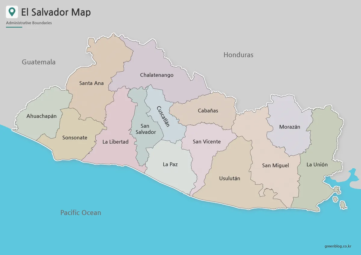
The color El Salvador map gives each department a muted fill while using blue for the Pacific and gray for neighboring land. Thin internal lines keep adjacent areas distinct, and a light outer stroke separates the national boundary from Guatemala and Honduras. The palette is restrained enough for labels to remain the main source of information rather than turning the page into a dense thematic chart.
Color is particularly helpful in the center. San Salvador is narrow and vertically oriented, Cuscatlán angles beside it, and La Libertad and La Paz continue toward the coast. Separate fills make those shapes easier to follow. In the east, color also clarifies the sequence from Usulután and San Miguel to Morazán and La Unión without requiring arrows or a legend.
This version works well when readers need immediate orientation, such as on an opening presentation slide, in a country profile, or as an answer key. It can also serve as the reference image beside an unlabeled exercise. When new data is added, symbols or a transparent overlay help keep the original department colors and names readable.
Black and White Printable Version
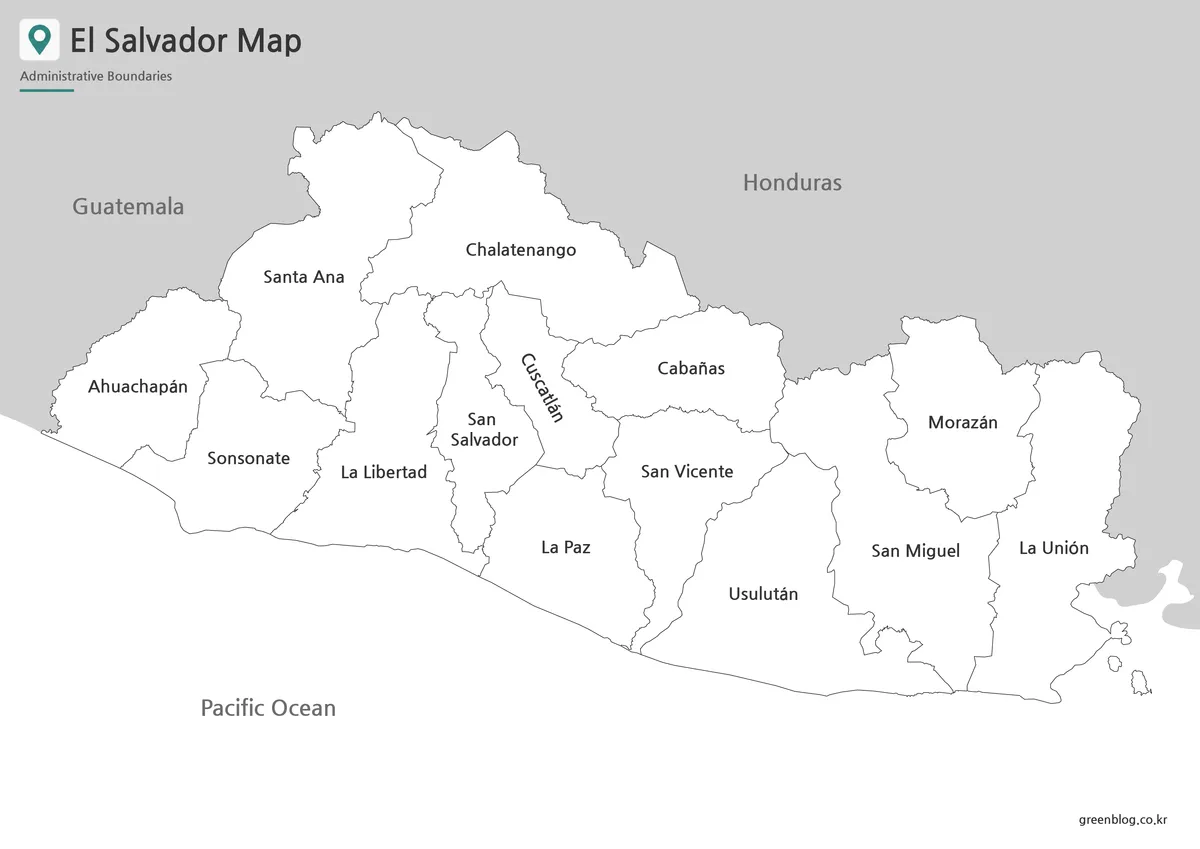
The black and white El Salvador map retains all fourteen department names, both neighboring-country labels, and the Pacific Ocean label. White department interiors and fine gray boundary lines reduce ink use while preserving the same geography as the color version. The country stays visually separate from the gray land beyond its borders, and the coastline remains easy to trace across the wide page.
This format works well for photocopied handouts, monochrome reports, study sheets, and notes. Learners can underline selected departments, add a north arrow, or mark a few places without competing with background colors. Since the labels are already supplied, it is also useful as a reference sheet when the activity is about regional grouping rather than name recall.
A test page is useful before producing a full classroom set because it reveals whether the smallest central labels remain clear. The landscape aspect ratio stays clearest when it is preserved instead of being stretched to fill a portrait page. When space is limited, placing the map across the wider part of a document or reducing it evenly keeps department shapes and text proportional.
Blank Outline Map for Editing
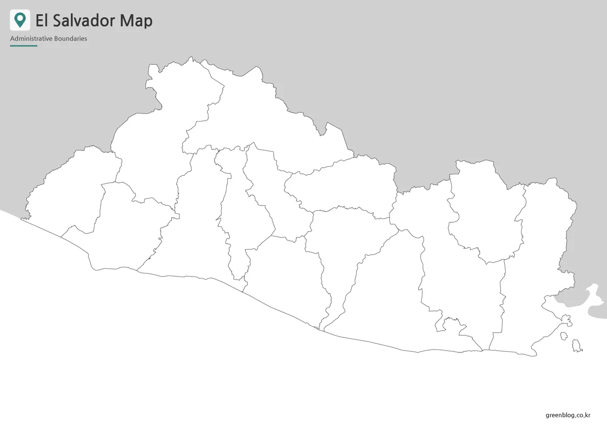
The outline El Salvador map removes the department, country, and ocean labels as well as the colored fills. It keeps the national outline, internal department lines, nearby border shapes, and coastal edge. This neutral structure suits activities in which users create the information instead of reading a completed reference.
Students can label the fourteen departments, identify which ones meet Guatemala or Honduras, and shade the departments along the Pacific. Another exercise can divide the country into western, central, and eastern groups and compare that result with the labeled map. Because no city points are built into the outline, teachers can decide which places belong in the lesson.
For graphic work, the blank version can hold a limited set of markers, routes, or statistical colors. Keeping a separate copy of the untouched file before editing protects the original, while a short legend helps explain colors used for data rather than ordinary department separation. The connected national edge also provides a clean silhouette for a cover image or simple regional locator.
Practical Ways to Use the Map Collection
A lesson can begin with the labeled color map, move to the black and white reference, and finish with the blank outline. This sequence lets students first recognize the structure, then concentrate on names, and finally reproduce the layout independently. An El Salvador map can also be paired with a Central America map so readers move between national detail and regional location.
In a presentation, the color version is strongest for a quick introduction, while the monochrome version sits comfortably beside tables or explanatory text. The outline is better for a focused diagram in which only selected departments need emphasis. Using the same base geometry across all three styles prevents the visual shifts that can occur when unrelated maps are combined in one project.
Travel-oriented graphics may mark a few destinations or connect the capital area with western and eastern locations, while roads and city symbols are not included in the supplied maps. Limiting additions to features needed for the specific topic helps preserve the map’s clarity. A small number of clear markers will preserve the department boundaries and make the result easier to read on screens and printed pages.
What Is Included
The El Salvador map collection includes:
- a color-coded map with all 14 departments labeled
- a black and white labeled version
- a blank outline with department boundaries
- Guatemala, Honduras, and Pacific context on the labeled maps
- a landscape composition prepared for A3 use
- coordinated files for reference, printing, and editing
Municipal borders, roads, city markers, elevation, and waterway layers are not part of this set. The limited scope is intentional: it keeps the fourteen-department framework legible and gives users room to add project-specific information to the outline.
Frequently Asked Questions
Can I print the El Salvador map at A3 size?
Yes. The layout is prepared for A3 printing and can also be reduced for smaller handouts. A print preview helps confirm margins and scaling before printing.
Which version is best for a classroom worksheet?
The outline version is the most flexible choice for labeling, coloring, and regional exercises. The black and white map is better when department names need to remain visible.
Does the collection show all local municipalities?
No. It shows the 14 main departments rather than smaller municipal divisions, keeping the national layout clear and readable.
Can I add my own colors and markers?
Yes. The blank El Salvador map provides a clean working base for city points, travel routes, statistics, presentation highlights, and infographic annotations.
Download Information
The labeled color file is suited to immediate comparison, the black and white file to economical printing, and the blank outline to original labels and data. The download brings the three versions together so one project can use a consistent national and departmental shape.
Map File Information
This download contains three printable El Salvador map styles for reference, classroom activities, presentations, and custom graphics.
- Included Versions: Color, black and white, and outline
Additional Resources
- El Salvador National Statistics Office (ONEC/BCR) documents the country’s administrative division into 14 departments and provides an official reference for the department framework shown on these maps.
Related Maps
Green Map creates custom-edited map images using open geographic data sources such as geoBoundaries, Natural Earth, OpenStreetMap, and government open data.
These maps are edited visual materials, not raw data files, and are provided for education, documents, presentations, and graphic reference.