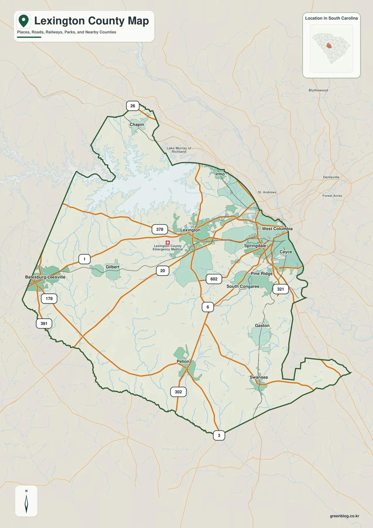
Lexington County combines a large reservoir, a cluster of cities on the Columbia side, and a much broader interior that stretches south and west. This page uses the Lexington County Map package to show where Lexington, West Columbia, Cayce, Irmo, Chapin, and the county’s smaller communities sit in relation to Lake Murray, major numbered roads, and the waterways that cross the county. The on-page maps are WEBP previews, and readers can download an A3 high-resolution JPG ZIP below for printing, classwork, presentations, or county-to-county reference.
The package contains a county overview with places and roads, a ranked major-city distribution map, and a terrain-and-water map. Those three views reveal more than the old boundary-only article did. The northwest is dominated by Lake Murray, the eastern side contains Lexington and several communities close to the Columbia area, and the southern half has a wider spread of towns, creeks, ponds, and roads. Reading the maps together makes it easier to understand how different parts of Lexington County relate to one another without treating the page as a street atlas, flood map, or survey product.
Table of Contents
Lake Murray, Lexington, and the County’s Uneven Shape
The county overview is visually anchored by Lake Murray in the northwest. Its branching shoreline reaches far into the upper part of the county, while Lexington lies southeast of the lake near the middle of the more developed eastern half. The source package identifies Lexington as the county seat and retains background facts from the earlier article, including an 1804 founding date and 699 square miles of land area. Those figures are context rather than measurements taken from the map, so the boundary, place labels, water, and road network remain the best guides for reading the image itself.
East of Lexington, West Columbia and Cayce sit close to the county’s eastern edge, with Springdale nearby and Irmo farther north. The west and south look very different. Gilbert and Batesburg-Leesville are separated from the Columbia-side cluster, while Pelion, Swansea, and Gaston spread across the lower half of the county. Chapin occupies the narrow northern section above Lake Murray. This arrangement makes Lexington County a poor fit for a simple “one center, one ring of suburbs” description; the lake, the eastern city cluster, and the broad southern interior all create distinct reference areas.
The overview also labels several major road numbers, including 26, 20, 1, 378, 321, 6, 302, 178, and 391. The map does not attempt to show every local street, but the numbered routes make the county’s main connections easier to follow. Several routes converge around Lexington and the communities to the east, while other long routes reach Batesburg-Leesville, Pelion, Swansea, and the southern boundary. For a quick orientation, it is useful to find Lake Murray first, then Lexington, and then trace the numbered routes toward the eastern and southern communities.
A Six-City Pattern Concentrated Toward the East
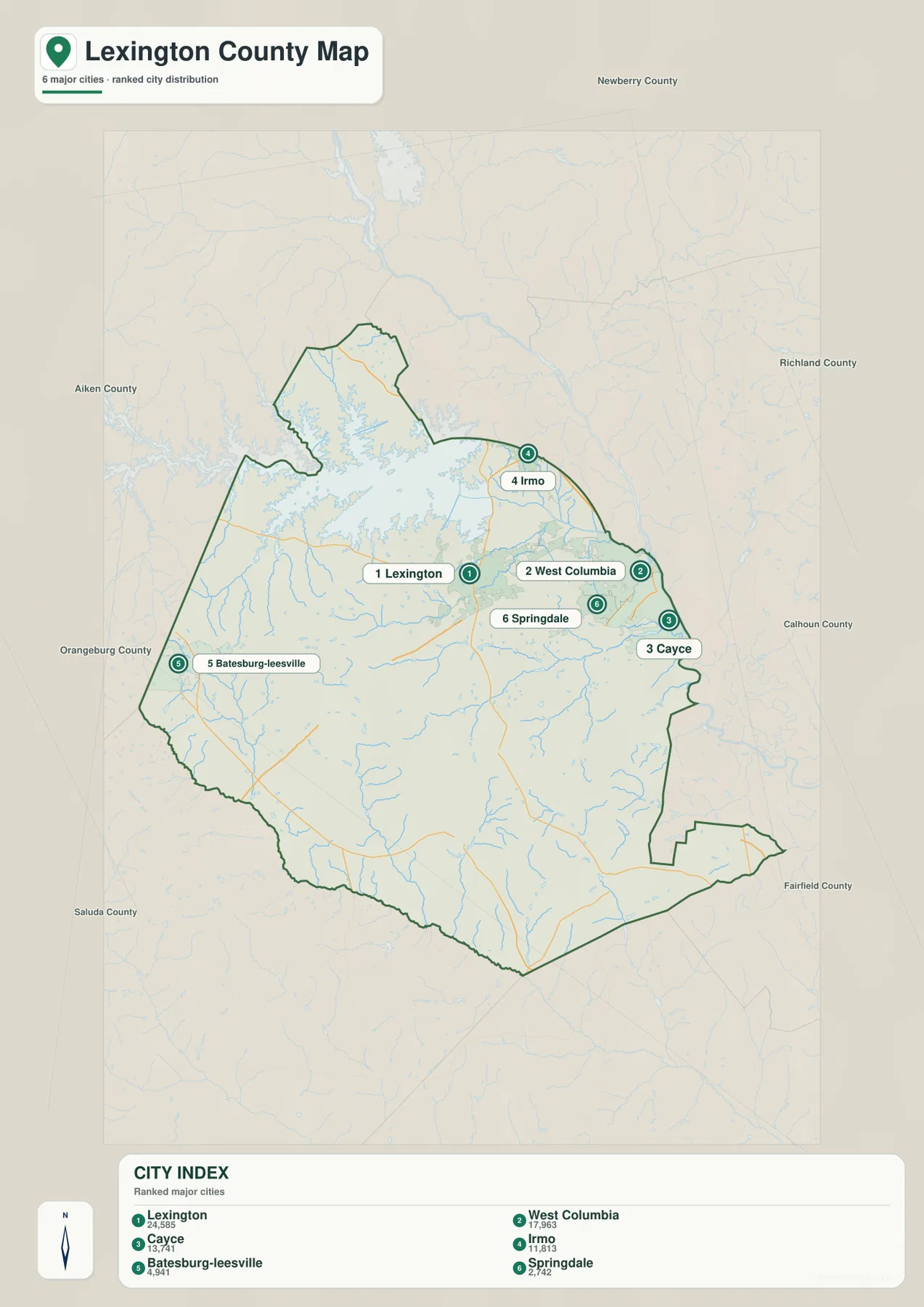
The city distribution map highlights six major places in a ranked index: Lexington, West Columbia, Cayce, Irmo, Batesburg-Leesville, and Springdale. The ranking is part of the supplied map and is used here as map content rather than as a claim about a separate current population dataset. What matters most for orientation is where these six places fall within the county. Five are in or near the eastern half, while Batesburg-Leesville sits well to the west, making the geographic imbalance immediately visible.
Lexington occupies a central-northeastern position. West Columbia and Cayce are farther east, close to the Richland County side, while Springdale is tucked into the same general cluster. Irmo lies to the north near the southeastern side of Lake Murray. Together, those locations form a dense set of reference points on the Columbia-facing side of Lexington County. A reader comparing only the city labels can quickly see why the eastern edge feels more urbanized on the map than the broad southwestern and southern portions.
Batesburg-Leesville provides a useful counterpoint because it appears near the western side rather than inside that eastern cluster. The city map also labels neighboring counties around the frame, including Newberry, Richland, Calhoun, Fairfield, Saluda, Orangeburg, and Aiken. These labels help place Lexington County within central South Carolina without requiring the article to invent adjacent-county relationships beyond what the map shows. The city map does not give driving time or route distance, so the positions should be used for directional comparison rather than trip planning.
From Lake Murray and the Saluda River to Southern Creeks and Ponds
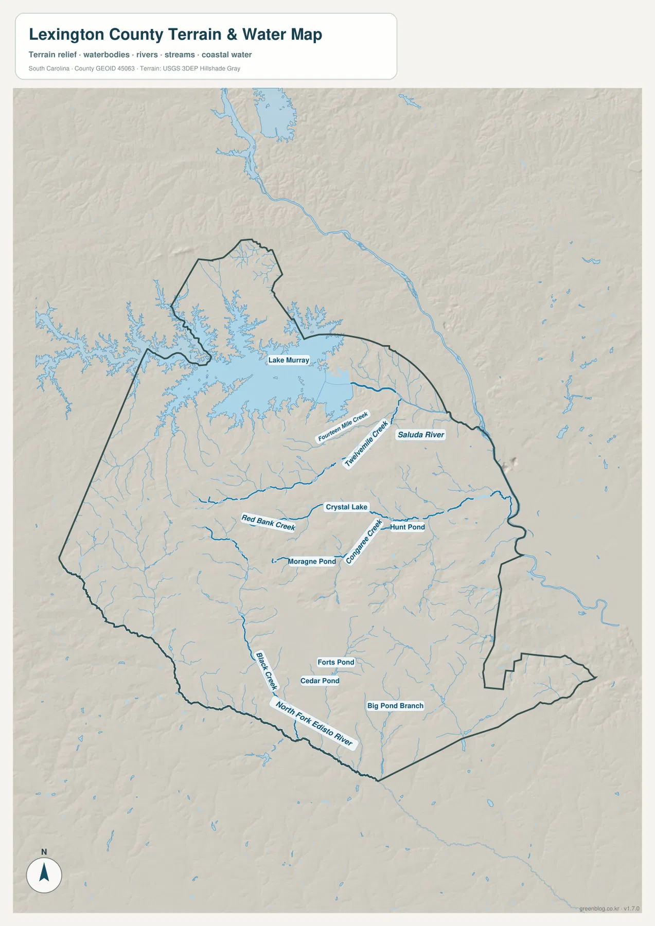
The terrain-and-water map makes Lake Murray the dominant feature in the northwest. From the lake area, the Saluda River is labeled as it continues eastward. Fourteen Mile Creek and Twelvemile Creek appear south and southeast of the lake, providing named tributary references in the upper-central part of the county. The shoreline and tributary network explain why the northern map looks much more water-rich than a simple county outline would suggest.
Farther south, the water map labels Red Bank Creek, Congaree Creek, Black Creek, Big Pond Branch, and the North Fork Edisto River. Several smaller water bodies are named as well, including Crystal Lake, Hunt Pond, Moragne Pond, Cedar Pond, and Forts Pond. The combination of one very large reservoir with many smaller creeks and ponds is useful when explaining the county’s geography. It also prevents the common mistake of treating Lake Murray as the only meaningful water feature within Lexington County.
The shaded background suggests broad terrain relief, but it should not be read as a survey-grade elevation model. Likewise, this is not a flood-risk map, navigation chart, parcel map, or water-quality report. It is best used to identify named rivers, creeks, ponds, and the general relationship between water and the county boundary. Readers who need hydrographic detail beyond the labels shown here can consult official USGS hydrography sources after using this map for initial orientation.
How the Roads, Cities, and Waterways Fit Together
Using all three maps together gives Lexington County a clearer internal structure. Irmo sits near Lake Murray, Lexington lies south of the lake, and West Columbia, Springdale, and Cayce form an eastern set of place references. Those same eastern areas are crossed by several of the major numbered roads on the county overview. West and south of Lexington, the towns spread farther apart, and the water map shows a larger network of smaller creeks and ponds rather than one dominant urban cluster.
A simple way to orient yourself is to divide the county into three reference areas. The northwest is the Lake Murray and Chapin area; the east is the Lexington-to-Cayce and Irmo-to-West Columbia side; the south and southwest include Pelion, Swansea, Gaston, Gilbert, Batesburg-Leesville, and the smaller streams leading toward the North Fork Edisto River. These are reading aids based on the visible map, not official planning districts or legal subregions. They help a reader move around the page without assigning new administrative meaning to the map.
For classroom or presentation use, the county overview works well as the first image because it establishes the boundary, places, and roads. The city map is better when the question is where the larger communities are concentrated, while the terrain-and-water map is the better choice for Lake Murray, the Saluda River, and named creeks. None of the maps should replace a live routing service for driving directions or an engineering dataset for drainage, elevation, or flood decisions. Their strength is clear regional reference at a consistent printable size.
Using the On-Page Maps and the A3 JPG Files
The WEBP images above are optimized for reading in the browser. The ZIP below contains the matching subjects as larger A3 high-resolution JPG files, so you can choose the county overview, the city distribution map, or the terrain-and-water map depending on the task. Keeping the original aspect ratio is recommended when resizing for slides or print, because stretching the image can distort the boundary and road geometry. The download is a single ZIP rather than three separate buttons, making it easier to keep the related files together.
Frequently Asked Questions
Where is Lake Murray on the Lexington County map?
Lake Murray occupies the northwest part of the county and is the largest water feature shown. Chapin is north of much of the reservoir area, while Irmo lies near its southeastern side. The water map also labels the Saluda River continuing east from the lake area.
Why do so many major-city labels appear on the eastern side?
The supplied city distribution map places Lexington, West Columbia, Cayce, Irmo, and Springdale in or near the eastern half of the county. Batesburg-Leesville is the major western exception. The map is showing their geographic distribution, not driving-time relationships, so a separate routing source is still needed for travel planning.
Can the terrain-and-water map be used to judge flood risk or navigable water?
No. It is a reference map for the location of Lake Murray, the Saluda River, named creeks, ponds, and generalized terrain relief. It does not provide flood zones, water depth, current water levels, navigation restrictions, or engineering-grade elevation measurements.
Map File Information
The ZIP contains A3 high-resolution JPG files for the Lexington County overview, major-city distribution, and terrain-and-water reference shown on this page.
- File Type: JPG
Related Maps
Sources and Reference Data
For additional official context, see the South Carolina Association of Counties, U.S. Census Bureau TIGER/Line Shapefiles, USGS National Hydrography, and the South Carolina Geological Survey. County-specific descriptions in this article are grounded first in the three supplied Lexington County map images and the preserved facts in the rewrite package.
Green Map creates custom-edited map images using open geographic data sources such as geoBoundaries, Natural Earth, OpenStreetMap, and government open data.
These maps are edited visual materials, not raw data files, and are provided for education, documents, presentations, and graphic reference.