You can view and download the Aiken County Map files directly from this page. The package includes a general county map, a ranked city map, and a terrain-and-water map; the matching high-resolution JPG versions are available together in a ZIP from the download box below. The browser previews are useful for a quick look, while the A3-proportion originals are better when you want to print the maps, enlarge smaller labels, or place them in a presentation.
The three views make different parts of Aiken County easier to recognize. On the general map, Aiken sits west of the geographic center, with North Augusta and Burnettown close to the western edge. Wagener is much farther east, New Ellenton is to the south, and Jackson lies toward the southwest. Switch to the water map and the road network fades into the background while Sand River, Horse Creek, South Fork Edisto River, Hollow Creek, Upper Three Runs, ponds, and smaller tributaries become the main reference points.
This guide stays close to the information visible in the supplied files. It explains the county outline, major numbered roads, the placement of named communities, the ranked city labels, and the waterways and relief shown on the terrain image. The maps are not parcel surveys, flood-hazard products, or street-navigation tools, so they should be used for county-wide orientation rather than address-level decisions.
Table of Contents
A western city cluster contrasts with the long reach toward Wagener
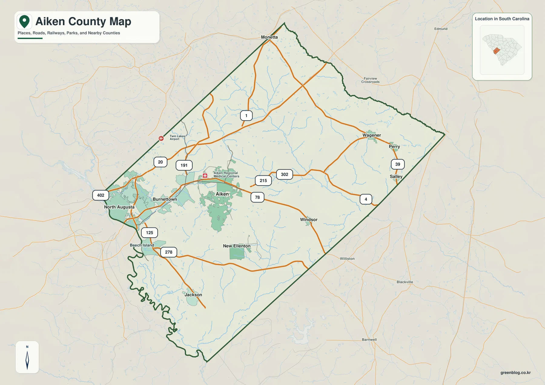
Aiken and North Augusta provide the clearest starting points on the general map, but they occupy different settings. Aiken lies inland in the western half of the county, where several numbered routes meet and the urban area occupies a broad patch on the map. North Augusta is pressed closer to the western boundary, with Burnettown nearby. Twin Lakes Airport and Aiken Regional Medical Centers are also labeled in this part of the map, adding useful landmarks when a reader is trying to orient the larger city names.
The county opens out considerably east of Aiken. Wagener is placed deep in the eastern portion, with Perry and Salley nearby, while Windsor and New Ellenton sit farther south. Jackson is near the southwestern side, and Monetta appears at the narrow northern tip. The result is a county where the most prominent urban labels are concentrated in the west, yet named communities continue across a long interior toward the east and south.
That spread is easier to appreciate on a map than in a simple list of place names. Aiken and North Augusta look relatively close when viewed at county scale, but Wagener is separated from them by a large central area. Jackson and New Ellenton form another southern set of references, while Monetta shows how far the county extends to the north. The outline itself reinforces the pattern: a narrow northern projection widens into a long diagonal body, with an irregular southwestern edge.
Routes 1, 78, and 278 help organize the county-wide road pattern
The general map does not attempt to show every local street. Instead, it emphasizes major numbered routes that make the county easier to read at a glance. Around Aiken, Routes 1 and 78 cross the western interior, with 215 and 302 also labeled nearby. The North Augusta side includes 20, 125, 278, and 402. Together, those lines show why the western portion looks more connected and visually dense than much of the eastern half.
Farther east, Routes 39 and 4 provide the clearest references around Wagener, Perry, and Salley. Route 1 continues toward Monetta in the north, while 278 and 125 help orient the southwestern side toward Jackson and the western boundary. These lines are useful for understanding direction and relative location, not for estimating travel time. A live road service is still the right tool for navigation, but this map works well when a report or classroom page needs to show where the principal communities sit within the county road framework.
The ranked city view removes road clutter and exposes the settlement pattern
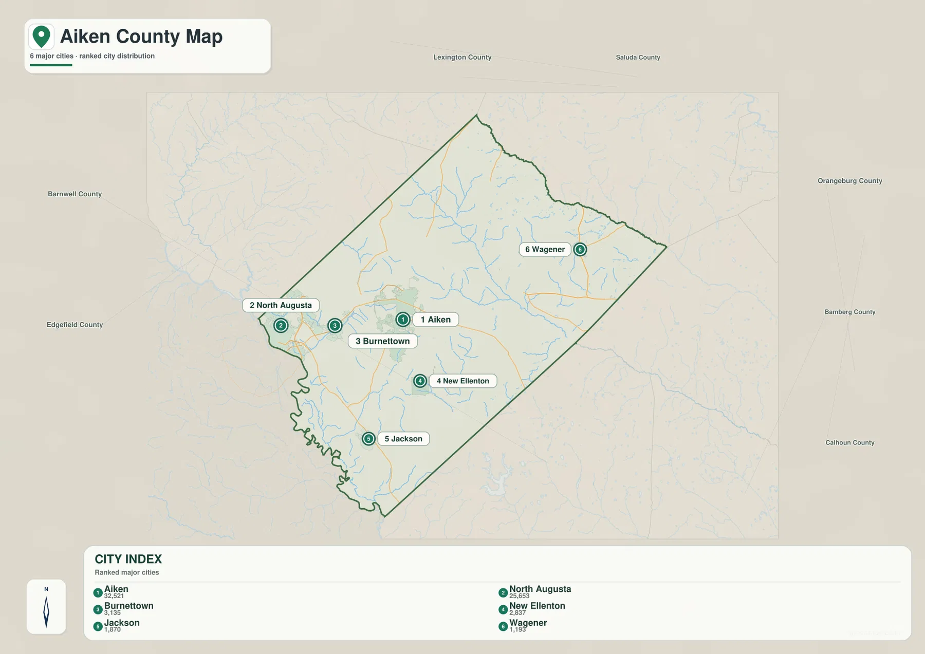
The city map highlights six places and prints a value beside each rank. Aiken is shown first at 32,521, followed by North Augusta at 25,653. Burnettown is labeled 3,135, New Ellenton 2,837, Jackson 1,870, and Wagener 1,193. Those numbers are values printed on the supplied graphic rather than a claim that this page has produced the newest population estimates. If current demographic figures are essential, they should be checked against the latest official source.
| Map rank | City | Value printed on map |
|---|---|---|
| 1 | Aiken | 32,521 |
| 2 | North Augusta | 25,653 |
| 3 | Burnettown | 3,135 |
| 4 | New Ellenton | 2,837 |
| 5 | Jackson | 1,870 |
| 6 | Wagener | 1,193 |
The geography of the six points matters more than the ranking alone. Aiken is west of center. North Augusta and Burnettown sit even closer to the western edge. New Ellenton and Jackson are separated to the south, while Wagener stands alone in the east. The arrangement makes the western concentration and the broader southern/eastern spacing immediately visible, which is useful for county profiles and presentations where the full road network would add unnecessary detail.
The outer margin also names surrounding counties, including Lexington, Saluda, Orangeburg, Bamberg, Calhoun, Barnwell, and Edgefield. Those labels are not part of the six-city ranking. They simply provide regional context so the reader can see which side of Aiken County faces each neighboring area. Keeping that distinction clear prevents the outside labels from being mistaken for points inside the county.
Sand River and South Fork Edisto River divide the water map into clear reference areas
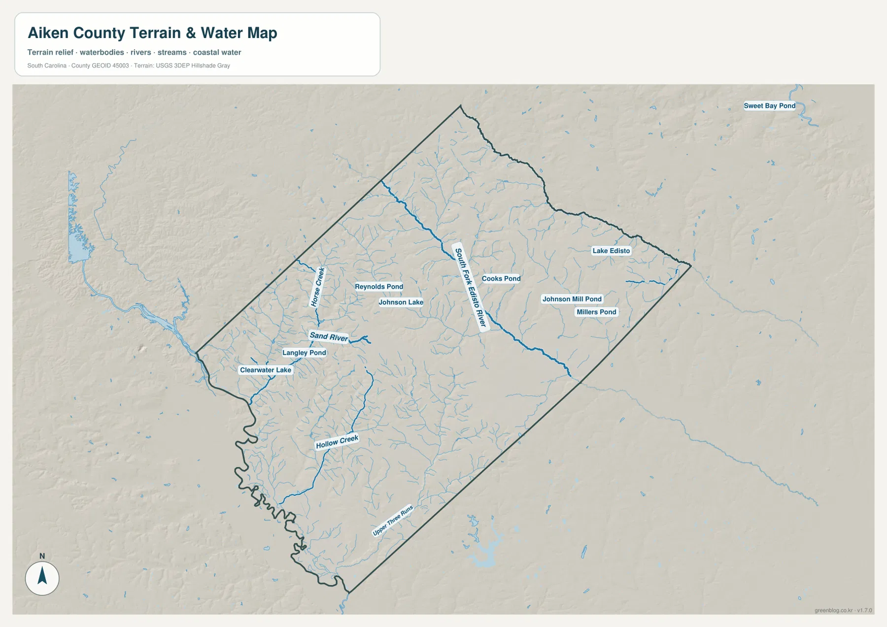
The terrain-and-water map is the best file when waterways matter more than roads. Horse Creek runs along the western side, and Sand River is labeled just to the south. South Fork Edisto River becomes the dominant named channel through the central-to-eastern interior. Hollow Creek appears in the southwest, while Upper Three Runs is labeled in the southern and southeastern part of the county. Between these larger names, numerous smaller blue tributaries branch across the map.
A useful way to read the image is to begin with one large waterway and then follow its surrounding tributaries. Sand River and Horse Creek orient the west, South Fork Edisto River provides a central/eastern reference, and Hollow Creek and Upper Three Runs organize the southern portion. This method makes the dense blue network easier to understand than trying to identify every small stream at once. The map can show where major rivers and creeks occur at county scale, but it does not determine whether a particular home, road, or parcel lies in a flood zone.
Named ponds and shaded relief add detail between the major streams
The water map includes several named lakes and ponds that act as smaller landmarks. Clearwater Lake and Langley Pond are labeled in the west. Reynolds Pond and Johnson Lake lie farther inland, Cooks Pond appears near the center, and Johnsons Mill Pond and Millers Pond are labeled to the east. Lake Edisto is farther northeast. These water bodies are not presented as identical features; their value here is that they provide additional reference points within a stream network that would otherwise contain many similar-looking blue lines.
Shaded relief adds another layer without turning the graphic into a technical elevation chart. The western and northwestern parts show more visible small valleys and surface variation, while broad areas toward the south and east appear gentler. The image is therefore useful for seeing how waterways follow low areas and how the land surface changes across the county, but it should not be used to read exact elevations. For precise terrain values or geologic interpretation, the official USGS and South Carolina Geological Survey sources linked below are more appropriate.
Viewed together, the general and water maps tell a useful story about orientation. The road map makes Aiken, North Augusta, Wagener, Jackson, and the numbered routes easy to find. The water map removes most of that urban emphasis and replaces it with rivers, creeks, ponds, and relief. Moving between the two is often more informative than trying to combine every layer into one image, especially when the purpose is to explain either transportation or natural features clearly.
Use the high-resolution JPGs when labels and print size matter
The WebP previews are optimized for quick viewing on the page. The downloadable ZIP contains the same three map themes as high-resolution JPG files measuring 2572 by 3638 pixels. That extra size is useful when small water labels need to be enlarged, when a map is placed in a slide deck, or when the image will be printed at a larger scale. If you only need to confirm where a city lies, the preview may be enough; for detailed reading, the original JPG is the better choice.
Choose the map according to the information you want to emphasize. The general county map is best for the boundary, major communities, and numbered roads. The ranked city version simplifies the view when settlement locations are the subject. The terrain-and-water map is the strongest option for Sand River, South Fork Edisto River, the named creeks and ponds, and the shaded land surface. Keeping the three themes separate makes each file easier to read and lets you use only the layer that fits your report, lesson, or presentation.
Frequently Asked Questions
Where are Aiken and Wagener located relative to each other?
Aiken is in the western half of the county, while Wagener is much farther east. North Augusta and Burnettown are closer to the western boundary, and New Ellenton and Jackson are south of Aiken. The ranked city map gives the cleanest view of those relative positions.
Which file shows Sand River and South Fork Edisto River most clearly?
Use the terrain-and-water map. It labels Sand River, Horse Creek, South Fork Edisto River, Hollow Creek, Upper Three Runs, several ponds, and many smaller tributaries. If you also need roads and city names, compare it with the general county map.
Can I download the maps instead of using the browser previews?
Yes. The download box on this page provides a ZIP containing three high-resolution JPG files at 2572 by 3638 pixels each. Those originals are the better choice for printing, enlarging small labels, or inserting the maps into presentations.
Map File Information
Download the Aiken County map set as high-resolution A3-proportion JPG files. The ZIP includes the general county map, ranked city map, and terrain-and-water map for printing, presentations, and closer inspection.
- Included Files: county map, city map, terrain and water map
- Printable Size: 2572 × 3638 px each
- File Type: ZIP containing 3 high-resolution JPG files
Related Maps
Sources
The article is based first on the maps and validation material included in the supplied Aiken County rewrite package. The official resources below can be used to check county geography, hydrography, elevation, and general county information.
- South Carolina Association of Counties – County Information: county information and statewide county references
- U.S. Census Bureau TIGER/Line Shapefiles: county boundaries, roads, and geographic reference data
- USGS National Hydrography: rivers, streams, lakes, and hydrography data
- USGS 3D Elevation Program: terrain and elevation reference data
- South Carolina Geological Survey: statewide geology and physical-geography references
Green Map creates custom-edited map images using open geographic data sources such as geoBoundaries, Natural Earth, OpenStreetMap, and government open data.
These maps are edited visual materials, not raw data files, and are provided for education, documents, presentations, and graphic reference.