Greenville County, South Carolina is long enough from north to south that one county map can show two very different settings. Greenville and its surrounding communities form a dense road-and-city pattern in the middle and southern part of the county, while Travelers Rest points toward much rougher country near the North Carolina line. The maps on this page are designed to make that contrast easy to see. WEBP previews are shown in the article, and the matching three subjects are available as high-resolution A3 JPG files in a downloadable ZIP.
The county is best understood by using Greenville as a reference point rather than treating the outline as a single uniform area. Greer sits to the east, Mauldin and Simpsonville extend south and southeast, and Fountain Inn is farther toward the southeastern side. North of Greenville, Travelers Rest marks the transition toward wider road spacing, steeper relief, reservoirs, and river valleys. That north-to-south change is more informative than the boundary shape alone.
These are county-scale reference graphics. They are useful for locating major roads, comparing the positions of selected cities, and following named rivers and reservoirs across the county. They are not substitutes for live traffic maps, parcel surveys, flood-hazard products, or engineering data. For those tasks, use the appropriate current official source after using these maps for broad orientation.
Table of Contents
A road-and-place overview centered on Greenville
The general county map combines the county boundary with roads, communities, landmarks, and surrounding geographic context. Greenville occupies the most visually crowded part of the map, with the Greenville County Courthouse near the center of the developed area. Berea, Parker, Gantt, Wade Hampton, and Taylors appear around the city, while Greer stands near the eastern side and Travelers Rest is farther north.
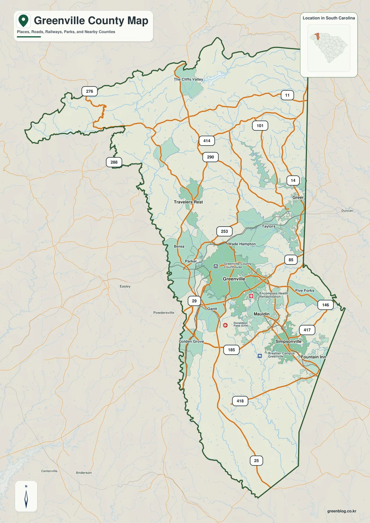
South of Greenville, the map shows Mauldin and Simpsonville along an increasingly suburban road network. Fountain Inn is positioned farther southeast, close to the county edge. This sequence is useful because it gives a simple sense of direction before a reader tries to follow individual route numbers. The contrast with northern Greenville County is immediate: the south has more closely spaced roads and place labels, while the north has more open space between roads.
The northern tip reaches the state-line side of the county and carries much stronger hillshade. The Cliffs Valley label and the US 276 area sit within terrain that looks visibly more folded than the Greenville urban area. As the map moves north, the built-up pattern fades and the relief becomes more prominent. That is why a map of Greenville County cannot be described accurately as only a metropolitan map.
Names outside the boundary provide useful orientation. Pickens and Anderson appear on the western side of the map area, while Spartanburg and Laurens provide eastern and southeastern references. These labels are especially helpful when comparing Greer with the east side of the county or understanding how Greenville sits within the wider Upstate region.
I-85 for the urban corridor, US 25 for the north-south view
I-85 is the easiest major route to use as an urban reference. It crosses the Greenville area and continues toward Greer, passing through the part of the county where roads and development are most concentrated. Looking at I-85 together with Greenville and Greer gives a quick picture of the county’s main eastward connection without requiring a detailed street map.
US 25 tells a different geographic story. It runs from the northern part of the county through the Travelers Rest area, passes west of central Greenville, and continues toward the south. Because it crosses several different landscape settings, it is a useful route for understanding how the county changes from mountain-influenced terrain to the central urban area and then toward the narrower southern section.
US 276 also connects the northern side with Travelers Rest and the Greenville area. US 29 approaches Greenville from the southwest, while SC 14 is visible on the Greer side of the county. Farther southeast, SC 417 and other state routes help connect the Simpsonville and Fountain Inn area. The purpose of the map is not to reproduce every road, but these labeled routes provide enough structure to understand the main directions of travel.
For a presentation or county overview, this general map is the strongest choice when roads and communities need to appear together. It shows where the urban area is dense and where the northern road network becomes sparse. It does not show current travel times, closures, or turn-by-turn instructions, so those details should come from a live transportation source.
Six city markers reveal more than a simple north-south line
The city map removes much of the road detail and gives six selected city references more visual weight: Greenville, Greer, Mauldin, Simpsonville, Fountain Inn, and Travelers Rest. The result is a cleaner view of settlement direction. Greenville functions as the central anchor, but the other five markers show that the county’s urban pattern spreads in several directions rather than following one straight corridor.
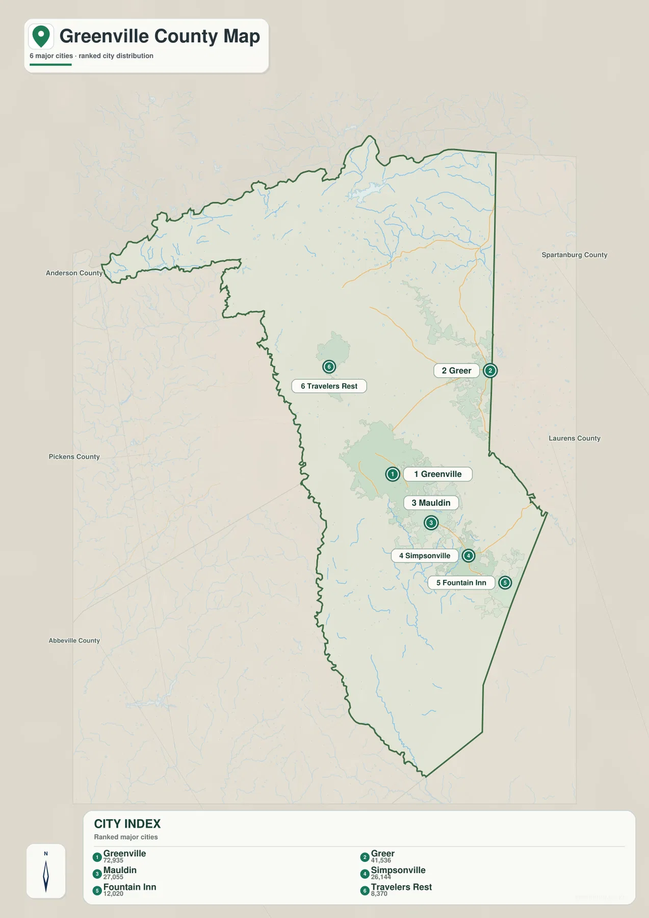
Mauldin lies immediately south of Greenville, and Simpsonville is farther in the same general direction. Fountain Inn extends that sequence toward the southeastern edge. Together, those three locations make the southern and southeastern expansion of the urban area easy to explain. A reader can understand their order even without the dense road labels shown on the general map.
Greer and Travelers Rest provide two very different outer references. Greer is near the east side, closer to the Spartanburg County direction and the I-85 corridor. Travelers Rest is north of Greenville and much closer to the higher relief shown on the terrain map. Their positions demonstrate that Greenville County’s settled areas branch east, north, and southeast from the central city.
The City Index printed on the supplied map lists Greenville at 72,935 and Greer at 41,536. Mauldin is shown at 27,055, followed closely by Simpsonville at 26,144. Fountain Inn is listed at 12,020 and Travelers Rest at 8,370. Those are the reference values used for this map’s ranking; they should not be treated as a live population database.
For current official population estimates, consult the latest U.S. Census Bureau release. The value of the city map here is primarily geographic. It helps readers see which selected cities are close together, which ones sit near county edges, and how the central Greenville cluster relates to the northern and eastern parts of the county.
Reservoirs in the north, the Reedy River through the center and south
The terrain-and-water map makes the county’s physical contrast clearer than the road map can. Shaded relief is strongest in the north and northwest, where ridges and valleys are closely spaced. Farther south, the surface becomes less rugged and the river network crosses broader terrain. Named water features are drawn over the relief, allowing the shape of the land and the direction of the waterways to be read together.
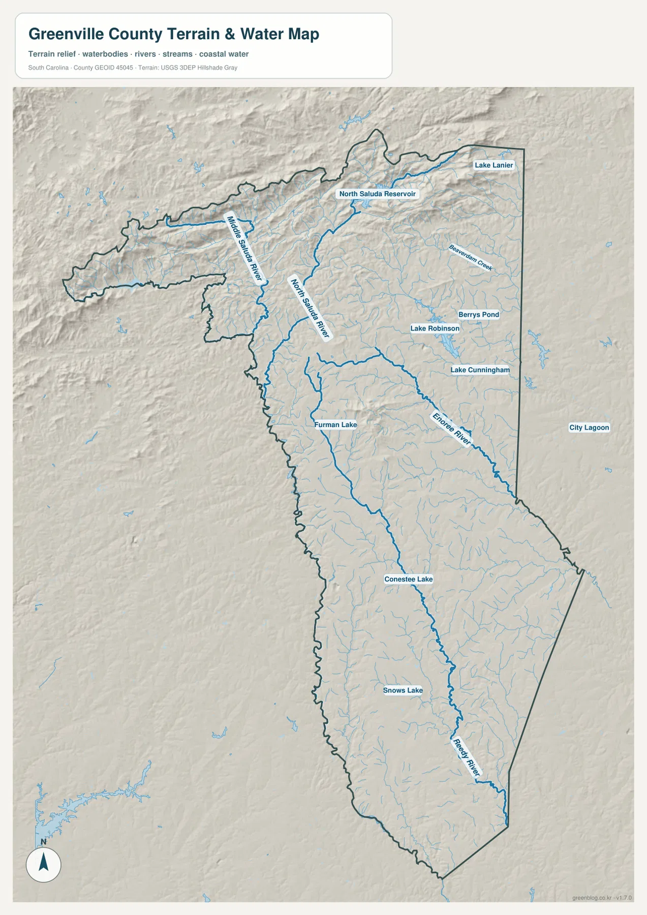
North Saluda Reservoir is one of the most prominent features in the northern half. The North Saluda River continues away from the reservoir area, while the Middle Saluda River follows a separate valley farther west. Lake Lanier appears near the northeastern edge. These features sit within the roughest-looking terrain on the map and help explain why the north is visually different from central Greenville.
On the eastern side, Lake Robinson and Lake Cunningham are clearly labeled, with Berrys Pond nearby. Smaller streams feed through the same general part of the county. Their placement shows that the northern and northeastern landscape includes a series of reservoirs and water bodies rather than one dominant river alone.
The Reedy River is the easiest named waterway to follow from the Greenville area toward the south. It passes near Conestee Lake and continues through the lower part of the county. The Enoree River is farther east and follows a separate course. Seeing both rivers on the same map helps distinguish the central-southern drainage from the eastern side of the county.
Furman Lake and Snows Lake are also labeled, adding smaller reference points between the larger river and reservoir features. The map is useful for broad physical geography, but it is not a flood map or a navigation chart. Water levels, flood zones, engineering measurements, and site-specific drainage questions require current specialized data.
Choosing a map for roads, city position, or physical geography
Use the general county map when the task is to show the county outline, major roads, and many place names in one figure. It is the best option for locating Greenville relative to Greer and Travelers Rest, or for showing how I-85, US 25, and US 276 fit into the wider county. The surrounding labels also make it suitable for regional orientation.
Use the city map when the relationship among the six selected cities matters more than road detail. It makes the Greenville–Mauldin–Simpsonville–Fountain Inn sequence easy to follow and also separates Greer and Travelers Rest as eastern and northern references. This cleaner layout works well in slides, classroom material, or short county introductions.
Use the terrain-and-water map when rivers, reservoirs, or the north-to-south change in relief are the main subject. North Saluda Reservoir, the Saluda river system, the Reedy River, and the Enoree River are all labeled over shaded terrain. Pairing this map with the general road map can be especially useful when explaining how the urbanized center relates to the higher northern landscape.
The WEBP images in the article are optimized as previews. If you need to enlarge route labels, read water-feature names more comfortably, or place the maps in a printed document, use the A3 JPG files in the ZIP. The archive contains three high-resolution JPGs matching the three subjects shown on this page.
Frequently Asked Questions
Are the City Index numbers current official population figures?
No. The figures are the reference values printed on the supplied city map and are used to explain the ranking shown there. Check the latest U.S. Census Bureau data when you need a current official population estimate.
Why does northern Greenville County look much rougher on the terrain map?
The northern part of the county reaches higher, more strongly dissected terrain near the state line. Ridges and valleys create stronger shaded relief there, while the Greenville area and the southern county generally appear gentler.
Which river is easiest to use as a reference near Greenville?
The Reedy River is the clearest starting point. It can be followed from the Greenville area toward Conestee Lake and farther south, while the Enoree River is shown separately on the eastern side.
Map File Information
The ZIP contains three high-resolution A3 JPG files for Greenville County: the road-and-place county map, the six-city reference map, and the terrain-and-water map. Use the larger files when you need more detail than the WEBP previews provide or when preparing print material.
- Included Files: 3 high-resolution A3 JPG maps described on this page
- File Type: JPG files in a ZIP archive
- Intended Use: Printing, education, presentations, and map-based projects
Related Maps
Sources and Reference Data
- U.S. Census Bureau TIGER/Line: county boundaries and administrative geography
- USGS National Hydrography: rivers, streams, lakes, and reservoirs
- USGS 3D Elevation Program: elevation and terrain reference
- Greenville County Open Space Plan: county landscape, water, and natural-resource context
- South Carolina Association of Counties – County Information: county background information
Green Map creates custom-edited map images using open geographic data sources such as geoBoundaries, Natural Earth, OpenStreetMap, and government open data.
These maps are edited visual materials, not raw data files, and are provided for education, documents, presentations, and graphic reference.