The Laurens County South Carolina Map on this page is built around three different questions: where the county’s towns and major roads sit, how the main places relate to Laurens, and where the rivers and smaller streams run across the county. Laurens lies near the center of the road network, Clinton anchors the eastern side, Gray Court is to the north, and Waterloo and Cross Hill provide useful references in the southwest. Those differences are much easier to see with the new map set than with a simple county outline.
WebP previews are shown in the article, while the download box provides a ZIP containing three high-resolution A3 JPG files. The maps are meant to be used together, but each has a distinct job: one emphasizes roads and places, one simplifies the county into city connections, and one brings the Reedy River, Little River, Bush River, creeks, ponds, and shaded terrain to the front.
Table of Contents
Roads and settlements from Gray Court to Clinton
On the county map, Laurens is the central reference point. Clinton sits east of it, Gray Court is north, and Waterloo and Mountville lie farther south and southwest. Fountain Inn appears close to the northwestern edge, while Joanna is shown southeast of Clinton. This spread matters because Laurens County does not have a single compact urban cluster; the places are distributed across a broad, irregular county shape.
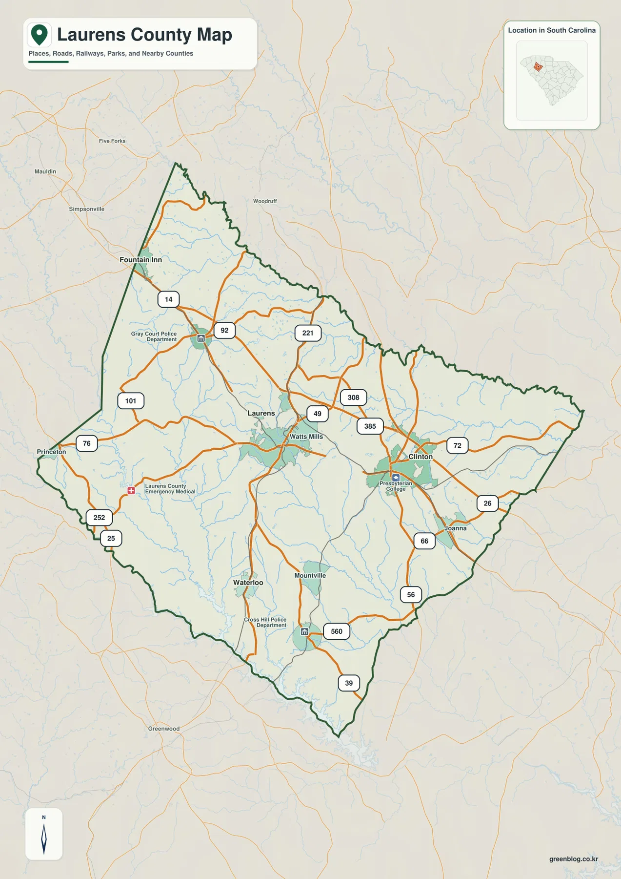
The road pattern helps explain how these places relate to one another. Interstate 385 approaches the Laurens–Clinton part of the county, and Interstate 26 is visible along the southeastern side. U.S. 221 provides a strong north-south reference, while routes marked 72, 56, 14, 92, 308, 49 and others fill in the local network. The map is not a turn-by-turn road atlas, but it is detailed enough to show why Laurens and Clinton function as prominent points within the county and how smaller places connect to them.
The pale context outside the county boundary is also useful. Roads continue toward Greenville, Greenwood, Newberry, Union, and other surrounding areas instead of stopping at the county line. That makes the county easier to place within northwestern South Carolina. For a report, classroom handout, or regional comparison, the map can show both the administrative boundary and the routes that continue beyond it without crowding the page with a full street network.
Laurens as a hub for four straight-line comparisons
The city-connections map removes much of the surrounding detail and makes Laurens the hub. Four other places are then compared with it: Gray Court, Clinton, Waterloo, and Cross Hill. The legend reports direct distances of about 7 miles to Gray Court, 12 miles to Clinton, 12 miles to Waterloo, and 16 miles to Cross Hill. These are straight-line distances, not driving distances, so they should be used for geographic orientation rather than route planning.
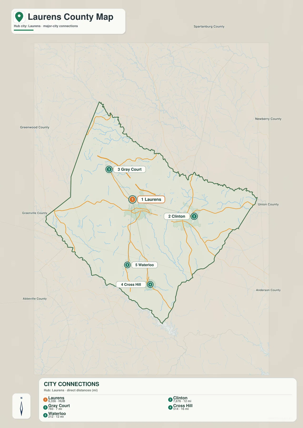
Gray Court is the closest of the four reference places and sits north of Laurens. Clinton is almost due east in the simplified layout, while Waterloo and Cross Hill pull the comparison toward the southwest. That arrangement creates a useful mental map of the county: north toward Gray Court and Greenville-area connections, east toward Clinton and Union/Newberry directions, and southwest toward the Reedy River side of the county.
Names of neighboring counties around the frame add another layer of orientation. Greenville County appears to the west-northwest, Greenwood and Abbeville to the southwest, Anderson toward the south, Union to the east, Newberry to the northeast, and Spartanburg to the north. The city map is not trying to show every community in Laurens County. Its strength is reducing a large county to a few dependable reference points and showing how those points sit inside the surrounding county pattern.
Reedy River, Little River, and the branching creek network
The terrain-and-water map changes the emphasis completely. The Reedy River is the strongest water feature on the western and southwestern side of the county. Little River runs through the south-central portion, and Bush River is prominent in the east. North and northeast of the county center, Duncan Creek and South Fork Duncan Creek form another recognizable system, while Warrior Creek and Dials Creek help define the upper part of the map.
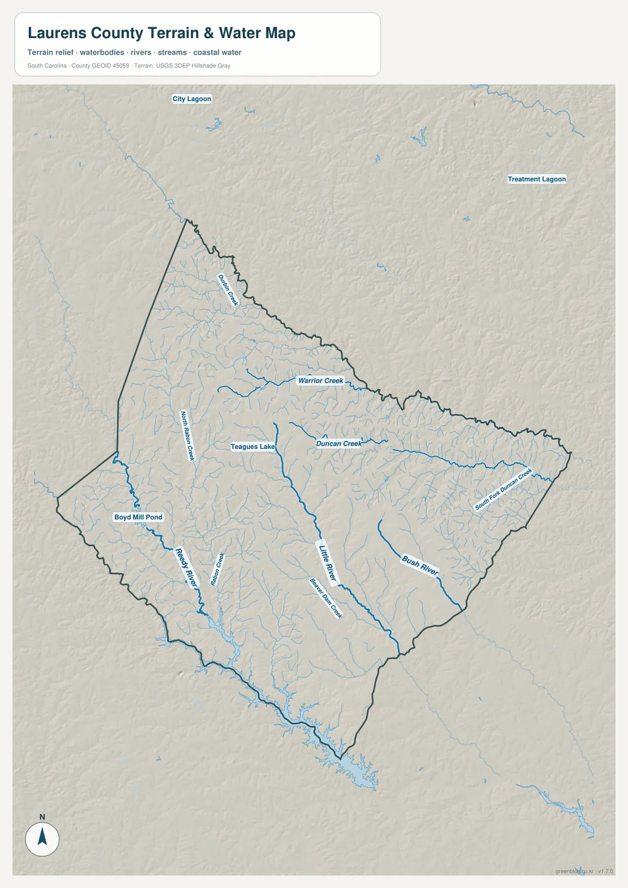
North Rabon Creek is visible in the western interior, and the map labels smaller water bodies such as Teagues Lake and Boyd Mill Pond. Those names are useful because they show that the county’s drainage is not limited to three large rivers. Thin blue tributaries fill most parts of the county, joining larger creeks and rivers in a dense network. For anyone trying to understand why the county’s land surface is gently broken rather than uniformly flat, the water map provides a clearer answer than the road map.
The shaded relief should be read as relative terrain, not as an exact elevation chart. No contour interval or point-elevation table is supplied in this package, so it would be misleading to assign precise heights from the image alone. What the map does show well is the repeated pattern of low stream valleys separated by rolling uplands. The drainage lines follow those lower areas, which makes the relationship between terrain and water visible even without numerical elevation labels.
Why the western and eastern sides look different
Laurens County stretches across enough territory that its western and eastern halves are best understood with different landmarks. In the west and southwest, Waterloo, Cross Hill, the Reedy River, North Rabon Creek, and smaller ponds are useful references. In the east, Clinton, Joanna, Interstate 26, Bush River, and the Duncan Creek system become more important. Laurens sits between those two broad areas and works as the easiest place from which to compare them.
The northern portion adds another layer. Gray Court is positioned toward the upper part of the county, and Fountain Inn is close to the northwestern edge. Roads from this area point toward the Greenville metropolitan side of the region, while the county’s northeastern boundary bends toward Spartanburg, Union, and Newberry directions. That mix of road connections and branching headwater streams is one reason a single outline map would leave out much of what is useful about Laurens County.
Choosing a map for roads, places, or water
Use the county overview when the main question is where Laurens, Clinton, Gray Court, Waterloo, Joanna, and other labeled places sit relative to the boundary and major routes. It is the best choice for a general county reference because roads, place names, streams, and neighboring context appear together.
Choose the city-connections map when you need a clean comparison centered on Laurens. Its 7-, 12-, 12-, and 16-mile labels are especially useful in presentations where the reader needs to understand relative separation without studying the full road network. Remember that those figures are straight-line distances rather than driving mileage.
The terrain-and-water map is the better file for rivers, creeks, ponds, and relative relief. It makes the Reedy River, Little River, Bush River, Duncan Creek, and many smaller tributaries much easier to follow. Because each map removes some information in order to emphasize something else, using the appropriate file is more useful than trying to treat one map as a complete source for every question.
Frequently Asked Questions
Are the city-connection distances driving distances?
No. The legend identifies them as direct distances from Laurens. Gray Court is shown at about 7 miles, Clinton and Waterloo at about 12 miles each, and Cross Hill at about 16 miles. Road mileage can be longer because actual routes do not follow straight lines.
Which waterways are easiest to identify on the Laurens County water map?
The Reedy River on the west, Little River in the south-central area, and Bush River in the east are the clearest large references. Duncan Creek, South Fork Duncan Creek, Warrior Creek, Dials Creek, and North Rabon Creek add detail to the tributary network.
Which downloadable file should I use for a report or printout?
Use the JPG that matches the subject of the report: the county overview for roads and locations, the city-connections map for relative place spacing, or the terrain-and-water map for rivers and relief. All three high-resolution A3 JPG files are included in the same ZIP.
Map File Information
The ZIP contains high-resolution A3 JPG versions of the Laurens County overview, city-connections map, and terrain-and-water map. Use these files when you need a larger image than the WebP previews shown in the article.
- Printable Size: 2572 × 3638 px each, A3 proportion
- File Type: JPG
Related Maps
Sources and Map Data
The geographic descriptions above are limited to features visible in the supplied maps and information preserved in the rewrite package. The following official sources are useful for checking county boundaries, hydrography, elevation data, and South Carolina county context.
- South Carolina Association of Counties – county information and administrative context
- U.S. Census Bureau TIGER/Line Shapefiles – boundary and transportation reference data
- USGS National Hydrography – rivers, streams, and waterbody reference data
- USGS 3D Elevation Program – elevation and terrain reference data
- South Carolina Geological Survey – statewide geology and physical-geography map resources
Green Map creates custom-edited map images using open geographic data sources such as geoBoundaries, Natural Earth, OpenStreetMap, and government open data. These maps are edited visual materials, not raw data files, and are provided for education, documents, presentations, and graphic reference.