Lancaster County South Carolina Map resources on this page go well beyond a single county outline. The three supplied maps show the county boundary and main routes, the relative position of Lancaster to Van Wyck, Heath Springs, and Kershaw, and a separate view of the Catawba River, reservoirs, creeks, and terrain. Matching high-resolution JPG versions of all three maps are available together in one ZIP download.
The shape of Lancaster County is one of the easiest features to recognize. A narrow northern section reaches toward Van Wyck, the county broadens around Lancaster, and the southern half extends toward Heath Springs and Kershaw. That long north-to-south arrangement makes it useful to compare settlements, routes, and waterways in separate maps rather than forcing every layer of information into one crowded image.
Table of Contents
A long county from Van Wyck through Lancaster to Kershaw
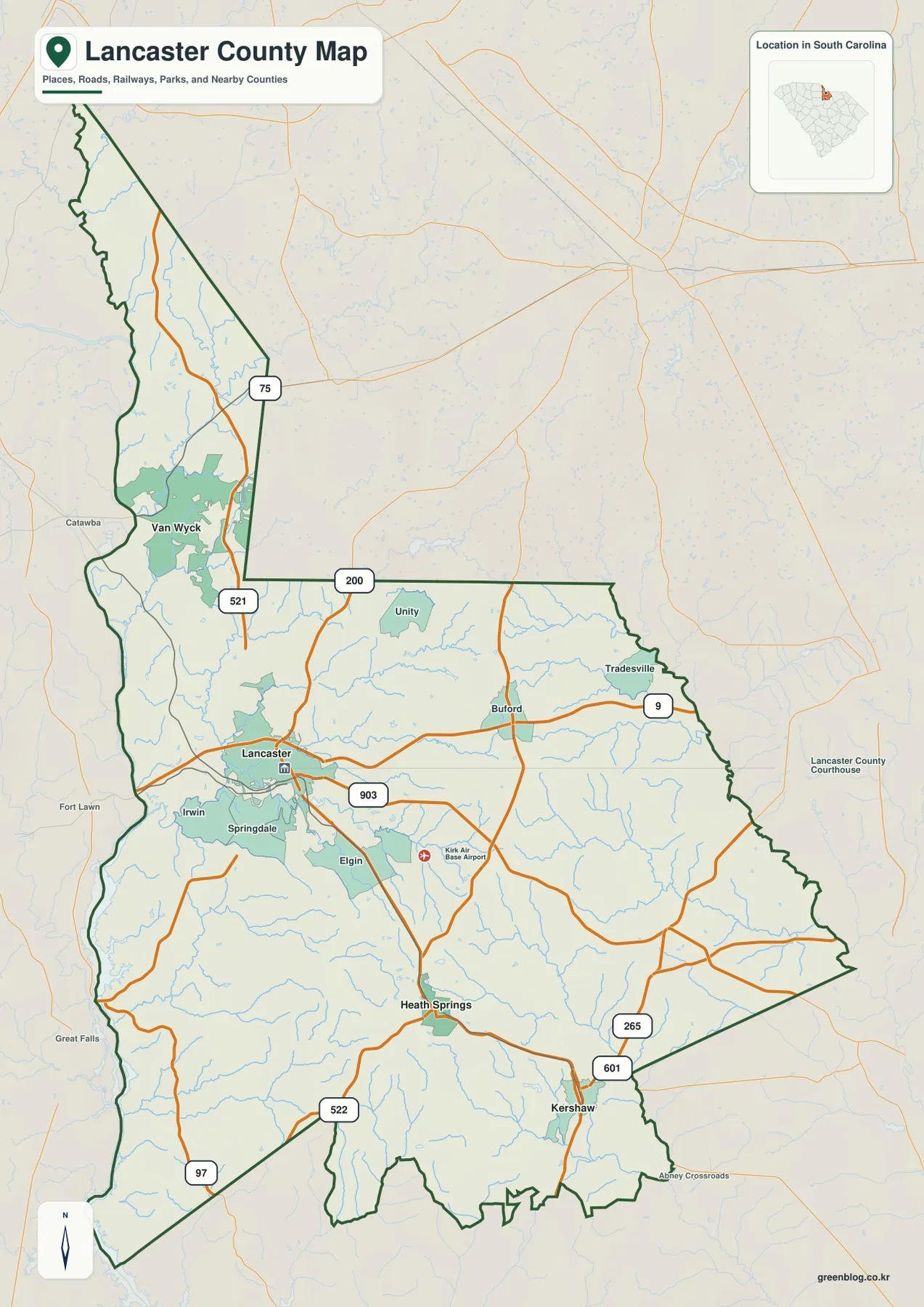
The county map makes Lancaster the clearest central reference point, but it also labels a wider set of communities. Van Wyck appears in the narrow northern part of the county, while Lancaster sits farther south and west of center. Heath Springs and Kershaw form two useful southern reference points, with Kershaw close to the southeastern side of the county. Smaller labels such as Unity, Buford, Tradesville, Irwin, Springdale, and Elgin help fill in the spaces between those larger place names.
This distribution matters because the county is not compact. Someone looking only at the Lancaster label could easily miss how far the boundary continues north toward Van Wyck or south past Heath Springs. The outline widens through the middle and becomes more irregular toward the southern end, so the county map is especially useful for understanding where each community sits inside the overall shape rather than treating Lancaster County as a simple rectangle.
Routes converge around Lancaster and spread across the county
Lancaster is also the point where the road pattern becomes easiest to follow. Route 521 runs through the north-south part of the map and connects the Van Wyck area with Lancaster. Route 9 continues east from Lancaster toward Buford and Tradesville, while 903 crosses the area south and east of Lancaster. Around Kershaw, routes 601 and 265 provide clear numbered references in the southeastern part of the county.
Other numbers shown on the map include 200, 522, 97, and 75. Together they provide enough detail to see how the county’s larger roads connect different areas without turning the page into a street-by-street navigation map. The map is therefore best used for orientation, regional comparison, or illustrating where communities sit in relation to the county boundary. It should not replace a navigation service when a precise driving route, turn, or address is needed.
The contrast between north and south is particularly clear along the major routes. The Van Wyck area is reached through the narrow northern extension, Lancaster acts as the central road hub, and the road pattern branches toward Heath Springs and Kershaw farther south. That arrangement matches the county’s elongated shape and explains why a single label at Lancaster is not enough to describe the geography of the whole county.
Straight-line city connections from Lancaster
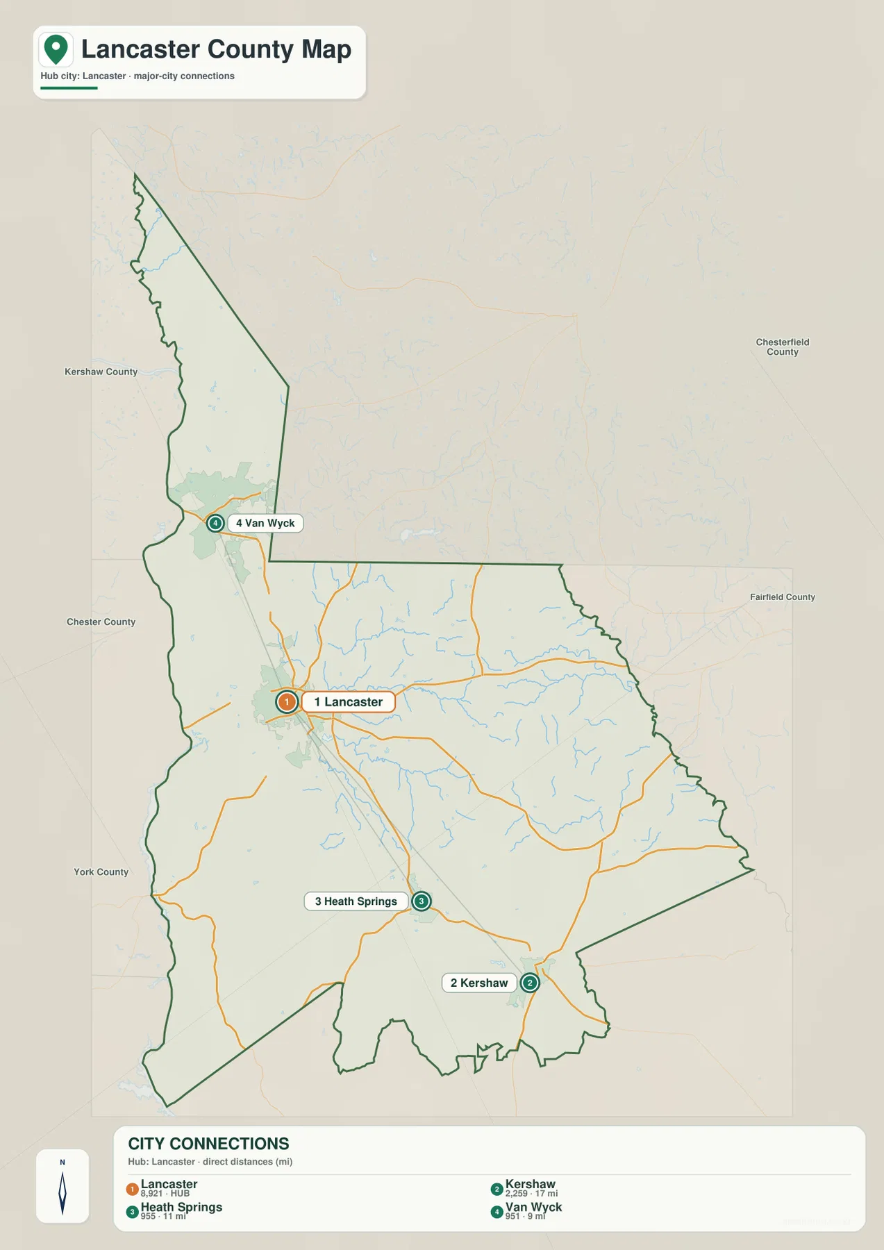
The city-connections map uses Lancaster as the hub and links it to three other places: Van Wyck, Heath Springs, and Kershaw. The distances shown are straight-line distances, not road mileage. Van Wyck is marked about 9 miles from Lancaster, Heath Springs about 11 miles, and Kershaw about 17 miles. Those values are useful for comparing spacing between the communities, but they should not be treated as driving distances.
Direction is just as useful as the numbers. Van Wyck lies north of Lancaster, Heath Springs lies to the south, and Kershaw is farther to the southeast. The three connector lines therefore point in different directions rather than following a single corridor. This shows why Lancaster works well as a reference point for the county: it sits between the northern and southern communities and provides a simple way to compare both distance and direction.
The connector lines themselves are not roads, municipal boundaries, or suggested travel routes. They are a visual device for measuring relative position. If a reader wants to know which community is farthest from Lancaster on this particular comparison, Kershaw is the longest of the three displayed connections. If the question is how the county stretches northward, the Lancaster-to-Van Wyck line makes the narrow northern section much easier to understand.
Catawba River, reservoirs, and the creek network
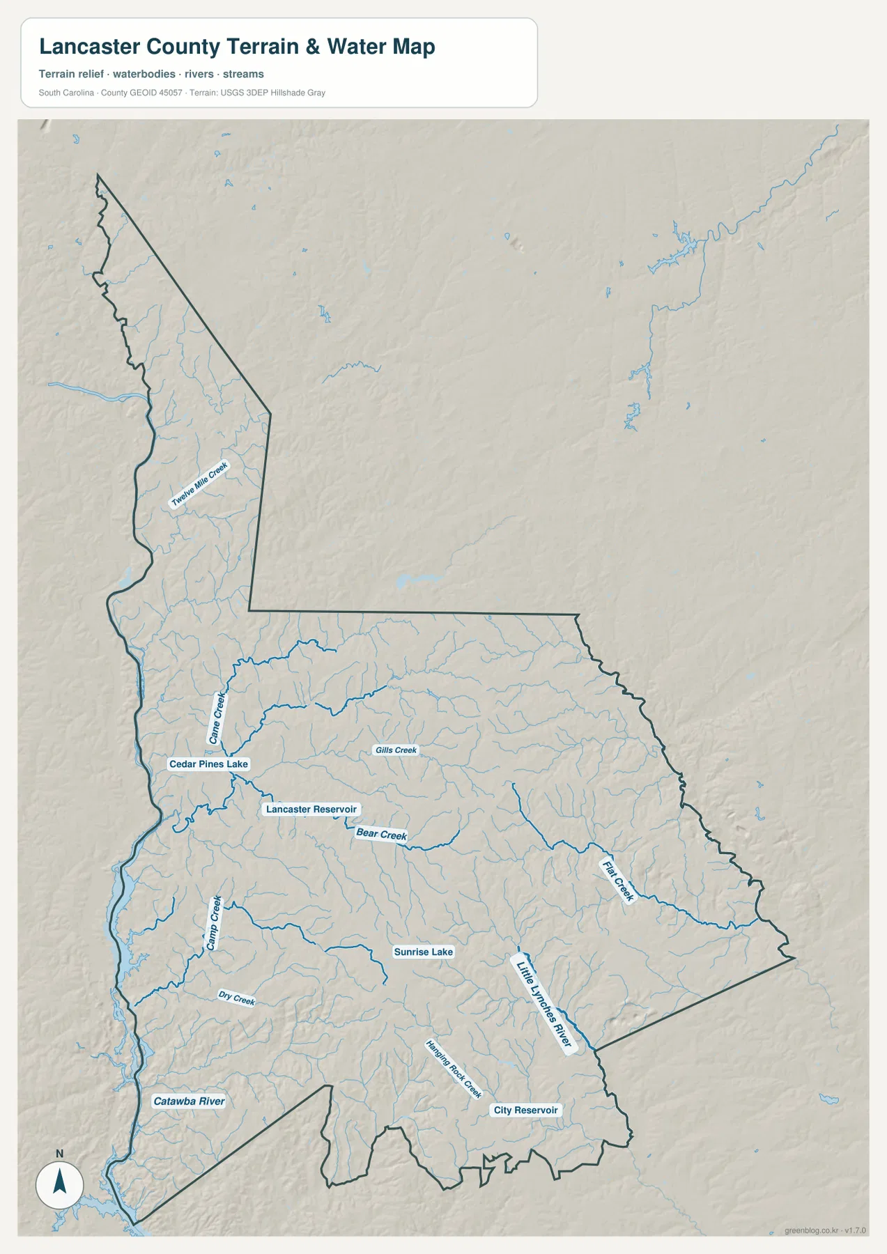
The terrain-and-water map changes the emphasis from roads and towns to the county’s drainage network. The Catawba River is the strongest water feature along the western side of the map. Numerous smaller tributaries feed toward that side, while the interior contains named lakes, reservoirs, and creeks. Cedar Pines Lake and Lancaster Reservoir appear in the west-central area, giving two clear water references close to the Lancaster side of the county.
Gills Creek and Bear Creek are labeled across the central part of the county. Farther east, Flat Creek extends across a broad section before reaching the southeastern side, while the Little Lynches River appears as a larger named waterway in the south and southeast. Twelve Mile Creek is labeled in the narrow northern section, which helps show that the county’s water network continues well beyond the Lancaster area rather than being concentrated only in the southern half.
The southern part of the map also includes Sunrise Lake and City Reservoir, along with many smaller streams that are visible without individual labels. These features make the water map useful when a project needs to distinguish rivers, creeks, reservoirs, and the general terrain from the road-and-settlement information shown on the other maps. The water map is not a flood-risk, property-boundary, depth, or navigation product, and the gray relief is a generalized terrain representation rather than survey-grade elevation measurement.
How the three Lancaster County maps complement one another
The county map is the best starting point when the main question is where Lancaster, Van Wyck, Heath Springs, Kershaw, and the numbered routes are located. Once those positions are familiar, the city-connections map adds a simple distance comparison centered on Lancaster. The terrain-and-water map then removes much of the road emphasis and brings the Catawba River, reservoirs, creeks, and relief into the foreground.
Looking north from Lancaster illustrates the value of combining the maps. The boundary narrows toward Van Wyck, route 521 gives a clear directional reference on the county map, and Twelve Mile Creek appears in the northern portion of the water map. Looking south instead brings Heath Springs and Kershaw into view, while the water map highlights Flat Creek and the Little Lynches River farther east and southeast. Each map answers a different part of the same geographic question.
For classroom work, reports, or a county comparison, the boundary map can serve as the basic locator image. The city map is more useful when the spacing among Lancaster and the three highlighted communities matters. The terrain-and-water map is the better choice for explaining rivers, creeks, reservoirs, and relief. Keeping all three JPG files makes it possible to choose the appropriate level of detail without redrawing or overcrowding a single map.
What stands out when comparing north, center, and south
The northern end is defined by its narrow shape and Van Wyck, while the middle of the county is organized around Lancaster and the denser convergence of roads. The south becomes wider and includes Heath Springs and Kershaw, with additional numbered routes extending toward the county edges. This creates three visibly different parts of the county even before the water layer is considered.
The waterways add another contrast. The west is strongly influenced by the Catawba River, the central area contains Lancaster Reservoir, Cedar Pines Lake, Gills Creek, and Bear Creek, and the eastern and southeastern areas include Flat Creek and the Little Lynches River. The result is a county where the most important road and water references do not all follow the same line, which is why separate maps make the geography easier to read.
Frequently Asked Questions
Is the 17-mile Lancaster-to-Kershaw value a driving distance?
No. The city-connections map uses straight-line distances between Lancaster and the three highlighted communities. Road mileage will vary with the route and exact starting point, so a navigation service should be used for driving directions.
Which map shows the Catawba River and Lancaster Reservoir most clearly?
The terrain-and-water map is the best choice. It labels the Catawba River along the western side and shows Lancaster Reservoir, Cedar Pines Lake, the Little Lynches River, Flat Creek, and several other waterways more clearly than the general county map.
What files are included in the ZIP download?
The archive contains three high-resolution JPG files matching the maps on this page: the county boundary-and-routes map, the Lancaster-centered city-connections map, and the terrain-and-water map.
Map File Information
The three Lancaster County maps used on this page are provided as matching high-resolution JPG files in one ZIP archive. Use the county map for boundaries and routes, the city map for straight-line connections, and the terrain-and-water map for rivers, creeks, reservoirs, and relief.
- File Type: JPG
Related Maps
Sources and map interpretation references
The map explanations above prioritize features visible in the supplied Lancaster County maps. The following official resources are useful references for county boundaries, hydrography, elevation, and general county information.
- U.S. Census Bureau TIGER/Line Shapefiles – county boundaries, roads, and place references
- USGS National Hydrography – rivers, streams, lakes, and other water features
- USGS 3D Elevation Program – terrain and elevation reference
- South Carolina Association of Counties – County Information – general county reference
Green Map creates custom-edited map images using open geographic data sources such as geoBoundaries, Natural Earth, OpenStreetMap, and government open data.
These maps are edited visual materials, not raw data files, and are provided for education, documents, presentations, and graphic reference.