Greene County occupies a distinctive part of northeastern Arkansas where Paragould sits on Crowley’s Ridge between two broad river lowlands. The Cache River drainage lies to the west, while the St. Francis River marks the lower eastern side of the county. The ridge itself runs southwest to northeast through the middle, creating a clear change in elevation, stream direction, and road layout. This page shows communities, roads, waterways, and an elevation range of about 71 to 169 meters. You can download the same four maps as high-resolution JPG files in one ZIP.
Paragould is the county seat and the strongest reference point on the map. The Encyclopedia of Arkansas describes Crowley’s Ridge as the defining landform of Greene County, bordered historically by the St. Francis River bottoms on the north and east and the Cache and Black River lowlands on the west. On the supplied county map, Paragould appears in the south-central portion of the ridge with Routes 49, 69, 34, and 412 connecting the city to surrounding communities. Locating the city and the ridge together makes the rest of the county much easier to understand.
Table of Contents
Paragould and Crowley’s Ridge form the county’s geographic spine
Paragould is the largest built-up area on the general map, and Crowley’s Ridge College is labeled just west of the city. Route 49 heads northeast toward Marmaduke, Route 69 continues south, and Route 34 connects areas to the northwest and east. U.S. 412 crosses the southwestern side of the county and ties into the wider Paragould road network. These roads do more than connect towns: their directions show how travel follows the higher ridge or descends toward flatter land on either side.
Oak Grove Heights is just north of Paragould, while Lafe lies farther north near Routes 141 and 135. Marmaduke is northeast of the main city close to Route 49, and Delaplaine occupies the northwestern side near Routes 90 and 304. Walcott appears west-southwest of Paragould near Routes 168 and 228. Reading these places relative to the ridge helps distinguish communities on or near the higher central land from those closer to the lower river plains.
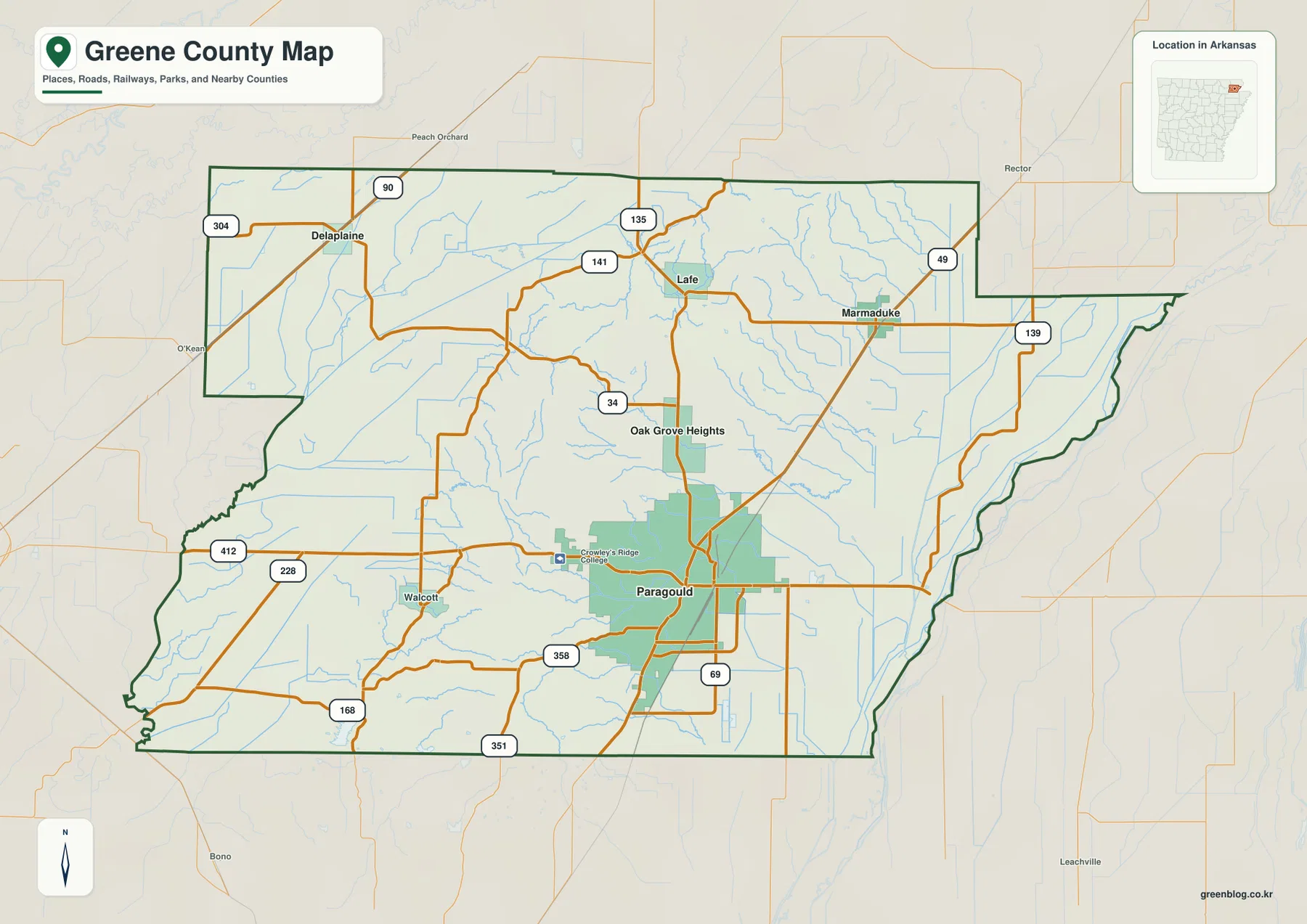
The county outline also reflects the surrounding lowlands. The eastern boundary bends near the St. Francis River and includes a projection toward the northeast. The western side borders Randolph and Lawrence counties, Clay County lies to the north, and Craighead County is immediately south. Because nearby roads and place names are shown in a lighter style beyond the boundary, the map is useful for placing Greene County within northeastern Arkansas without losing the local road detail.
The city ranking highlights Paragould and a widely dispersed northern group
The city map ranks five major communities. Paragould is first, followed by Marmaduke, Oak Grove Heights, Lafe, and Delaplaine. The numbered circles are ranking markers, not distance labels. Their locations show a county with one dominant city in the south-central area and several much smaller communities spread across the north, northeast, and northwest. There is no single straight urban corridor connecting all five places.
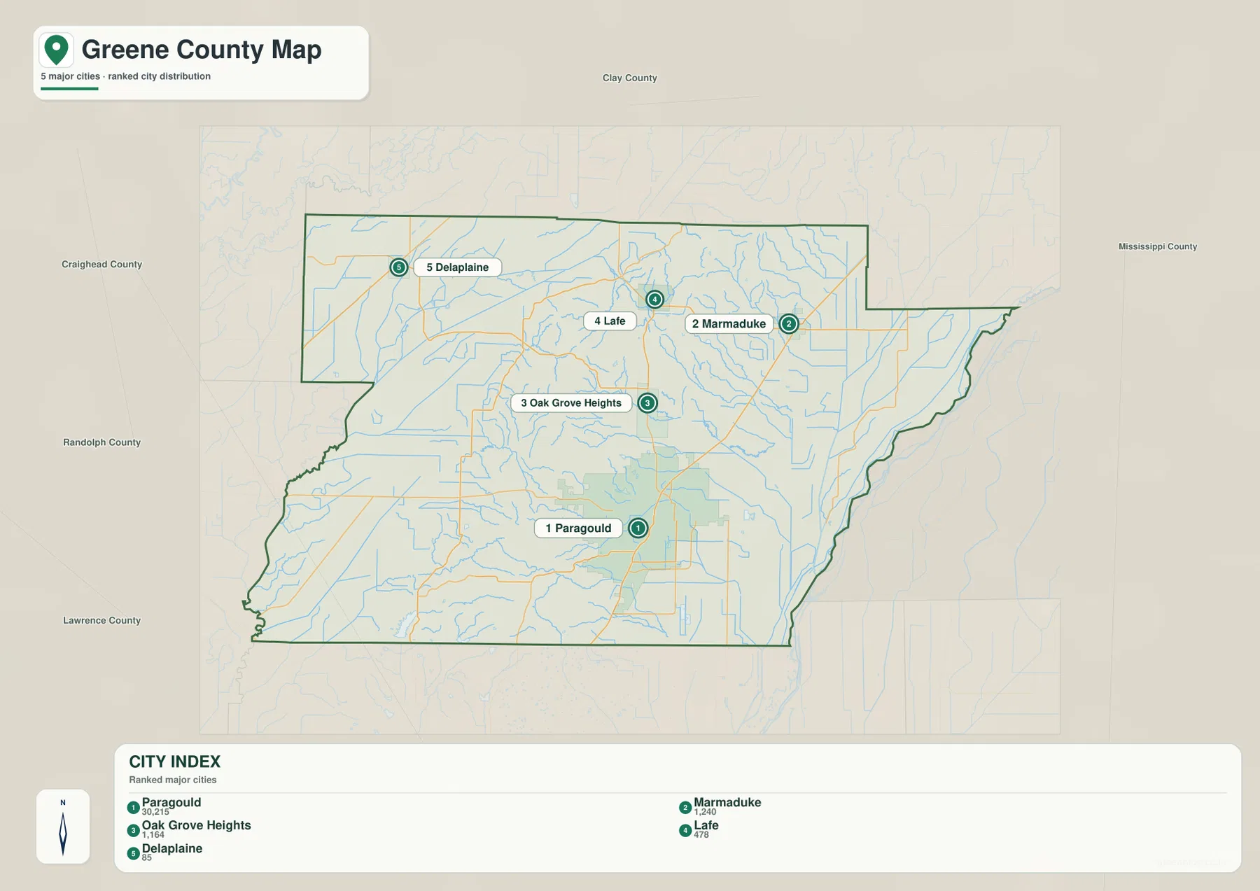
The settlement pattern becomes more meaningful when compared with terrain. Paragould and Oak Grove Heights sit close to the central and southern section of Crowley’s Ridge, and Lafe is also associated with the higher ridge country. Marmaduke lies farther toward the eastern lowlands, closer to the St. Francis River side. Delaplaine is in the flatter northwestern part of the county. Even without exact elevation labels on the city map, the separate elevation view makes these differences easy to connect.
The legend includes numeric values alongside the ranked city names, but this article does not treat those figures as current population estimates. The supplied map is being used for its city hierarchy and geographic distribution. Anyone needing current population totals should consult a recent Census source. For this page, the important point is that Paragould is shown as a much larger center than the other ranked communities and sits in a strategically central position on the ridge.
Cache River lowlands lie west of the ridge and St. Francis River lowlands lie east
The terrain and water map is easiest to read by starting with the two large river systems on opposite sides of the county. The Cache River is labeled in the northwestern lowland, while the St. Francis River follows the eastern edge. Crowley’s Ridge stands between them as a higher strip of land. The Encyclopedia of Arkansas uses this same contrast to explain much of Greene County’s settlement history, because the ridge historically provided higher ground between broad areas of swampy river bottom.
Smaller streams show how water drains away from the ridge. Big Creek crosses the north-central area, and Henderson Creek runs through the east-central side toward the St. Francis basin. South of Paragould, Johnson Creek and Eight Mile Creek occupy lower valleys. On the western side, drainage ditches and smaller channels lead toward the Cache River system. The water map therefore reveals a split drainage pattern rather than one river collecting every stream in the county.
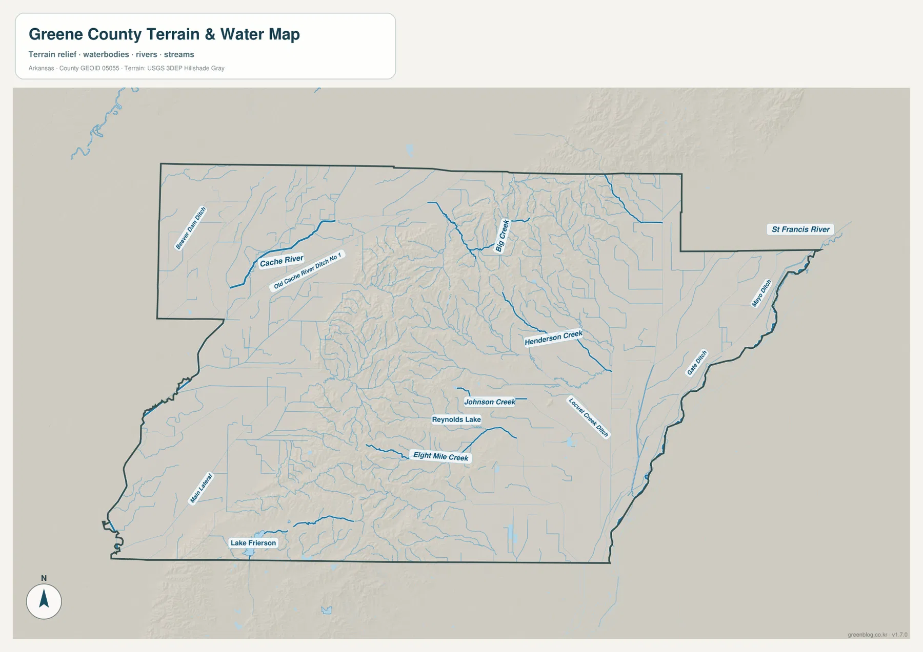
Lake Frierson appears near the southern part of the map, and Reynolds Lake is labeled closer to the south-central area. Arkansas State Parks describes Lake Frierson State Park as being on the shore of a 335-acre lake associated with the Crowley’s Ridge landscape. Comparing the general map with the water map helps place the lake relative to Paragould, Walcott, and the southern extension of the ridge. It also provides a useful landmark in a part of the county where many smaller streams are otherwise difficult to distinguish.
This map is intended for general geographic reference. It does not provide current river stage, flood risk, fishing rules, private-property boundaries, or real-time road access. Conditions on the Cache and St. Francis rivers can change with rainfall and upstream conditions. For recreation, flooding, or other safety decisions, use current information from USGS or the agency responsible for the specific water body.
The elevation map makes Crowley’s Ridge stand out against the flat plains
The supplied elevation map shows an actual range of about 71 to 169 meters, with a mean near 93 meters. A difference of roughly 98 meters may sound modest compared with mountain counties, but the surrounding plains are so low and flat that Crowley’s Ridge is visually prominent. Brown and tan terrain forms a long southwest-to-northeast band through the middle of the county, while broad green areas occupy the Cache River and St. Francis River sides.
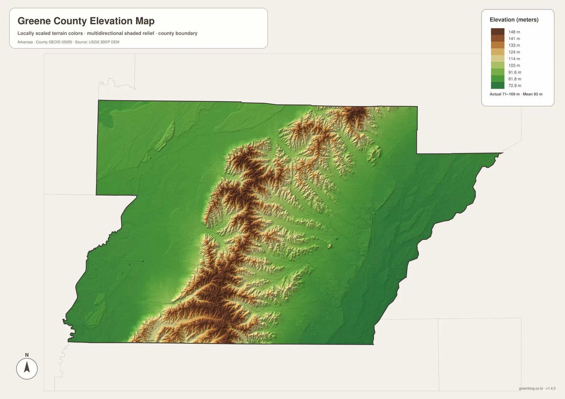
Crowley’s Ridge is not one isolated hill. The elevation view shows a connected series of rolling ridges with branches, short spurs, and narrow valleys. North and northeast of Paragould, the higher ground divides into several finger-like ridges, and another strong section extends toward the southwest. Arkansas State Parks notes that Crowley’s Ridge rises roughly 100 to 200 feet above the surrounding Delta plain. The county elevation map makes that local relief much easier to see than a single elevation number would.
The eastern St. Francis River side is much flatter and is dominated by green tones. The western Cache River side is also lower than the ridge, although subtle rises and channels remain visible. These differences help explain why roads, communities, and streams do not form the same pattern across the whole county. The elevation image is still a county-scale reference and should not be used to determine survey-grade heights for a parcel, road, building, or bridge. Precise work requires original USGS 3D Elevation Program data or a professional survey.
Compare east and west from Paragould to understand the county quickly
A practical way to use the four maps together is to start in Paragould and compare opposite directions. Moving west toward U.S. 412 and Walcott takes you down from Crowley’s Ridge toward the Cache River lowland, where channels and drainage features become more common. Moving east and northeast toward Marmaduke leads toward the flatter St. Francis River side. The same contrast appears in the elevation colors, so roads, water, and relief can be connected without studying each map separately.
Looking north from Paragould provides another useful comparison. Lafe and Route 141 remain close to the ridge, where the elevation map shows branching higher ground and the water map shows Big Creek and smaller valleys between ridges. Turning northwest toward Delaplaine, the land drops toward the Cache River system. Once those changes in height are understood, the positions of the county’s towns and roads become much easier to remember.
High-resolution JPG files for roads, waterways, and elevation detail
The WebP images in the article are optimized for quick page viewing. The download ZIP contains the same four maps as high-resolution JPG files, each measuring 3638 × 2572 pixels in landscape orientation. Use the general map for communities and roads, the city map for a simplified ranking and distribution of major places, the terrain and water map for rivers and named streams, and the elevation map for comparing Crowley’s Ridge with the low plains on either side.
The files are useful for classroom reference, presentations, trip preparation, personal printing, and general orientation. They should not replace legal boundary records, parcel surveys, flood studies, engineering plans, or live navigation. When exact or current information is required, consult Census TIGER/Line boundaries, USGS hydrography, USGS elevation data, and current state or local sources for the specific task.
Frequently Asked Questions
What is the county seat of Greene County?
Paragould is the county seat. It is the largest place shown on the general map and sits on the central Crowley’s Ridge corridor, where several major routes meet. Using Paragould as the starting point makes it easier to locate Marmaduke, Lafe, Delaplaine, and the river lowlands on both sides of the ridge.
Where is Crowley’s Ridge on the map?
On the elevation map, Crowley’s Ridge is the higher brown and tan band running southwest to northeast through the middle of Greene County. The displayed elevation range is about 71–169 meters with a mean near 93 meters. Lower green terrain spreads toward the Cache River on the west and the St. Francis River on the east.
Do the numbers 1 through 5 on the city map show distances?
No. They are city-ranking labels: Paragould is 1, Marmaduke 2, Oak Grove Heights 3, Lafe 4, and Delaplaine 5. They do not represent straight-line mileage or driving distance. Use a current road or navigation map when actual travel distance or time is needed.
Map File Information
The ZIP contains the general county map, ranked city map, terrain and water map, and elevation map as high-resolution JPG files for printing or offline reference.
- File Type: ZIP containing 4 JPG files
Related Maps
Sources and references
- Encyclopedia of Arkansas – Greene County – Paragould, Crowley’s Ridge, river lowlands, and county history
- Arkansas State Parks – Crowley’s Ridge State Park – official information on the ridge landscape near Paragould
- Arkansas State Parks – Lake Frierson State Park – official information about Lake Frierson and the surrounding ridge environment
- U.S. Census Bureau TIGER/Line Shapefiles – county boundary and road data
- USGS National Hydrography – rivers, streams, and waterbody data
- USGS 3D Elevation Program – elevation and terrain data
Green Map creates custom-edited map images using open geographic data sources such as geoBoundaries, Natural Earth, OpenStreetMap, and government open data.
These maps are edited visual materials, not raw data files, and are provided for education, documents, presentations, and graphic reference.