Petersburg Borough occupies a long, water-cut section of Southeast Alaska where islands, narrow channels, steep mainland coast, and scattered settled areas matter more than a single connected road grid. Petersburg and Kupreanof sit close together near Wrangell Narrows in the southern part of the borough, while the boundary reaches far north and east into much more sparsely developed country. This page uses a general borough map, an incorporated-city index map, and a terrain-and-water map to explain those relationships. The same high-resolution JPG files shown in the article are available together in the download box below.
The borough’s official boundary page says Petersburg Borough was incorporated on January 3, 2013 and covers about 3,829 square miles in total, including roughly 2,921 square miles of land and 908 square miles of water. That amount of water is not just a statistic in this part of Alaska. It appears directly in the mapped shape of the borough, where large islands, fjord-like inlets, passages, and river mouths repeatedly interrupt the land. The result is a county-equivalent that is best understood by looking at shorelines and waterways together with settlement names.
One administrative detail is especially useful before reading the city map. When the borough formed in 2013, the former City of Petersburg was dissolved and the new borough government succeeded it. The City of Kupreanof remained an incorporated city inside the borough. That is why Petersburg is a prominent place name on the general map even though the separate ranked city index contains only Kupreanof. The two maps are using different labels for different purposes rather than contradicting each other.
Table of Contents
A borough that joins islands, channels, and a mountainous mainland coast
The outline stretches across several distinct pieces of Southeast Alaska. The northern and eastern portions include broad mountainous mainland areas, while the southern half breaks into large islands and narrow waterways. Stephens Passage lies along the western side of the mapped region, and the lower part of the borough is divided by channels such as Wrangell Narrows and Duncan Canal. To the east, the boundary reaches toward the Alaska–Canada side of the Coast Mountains. Even without elevation numbers, the terrain backdrop makes it clear that this is not a flat coastal county-equivalent.
The official Petersburg Borough comprehensive plan describes a very large borough with extensive federal land and relatively limited developed areas. That pattern is easy to recognize in the supplied maps. Road lines are concentrated near Petersburg, Kupreanof, and a few other local areas rather than forming a continuous network across the borough. Much of the northern and eastern interior is visually dominated by coastlines, streams, ridges, and large undeveloped tracts. For readers trying to understand the borough for the first time, the distinction between a settled southern cluster and a much larger surrounding landscape is more useful than simply listing roads.
Hobart Bay appears well north of the Petersburg–Kupreanof area on the general map, giving a useful sense of the borough’s north-to-south extent. The southern map area, by contrast, contains more visible road lines and the closely spaced labels of Petersburg and Kupreanof. Those differences should not be read as a complete population map, but they do show that labeled places in the borough do not all share the same transportation setting or degree of development. A regional description is more accurate when it connects each name to the island, channel, or coast around it.
The general map puts Petersburg, Kupreanof, Hobart Bay, and the road network in one frame
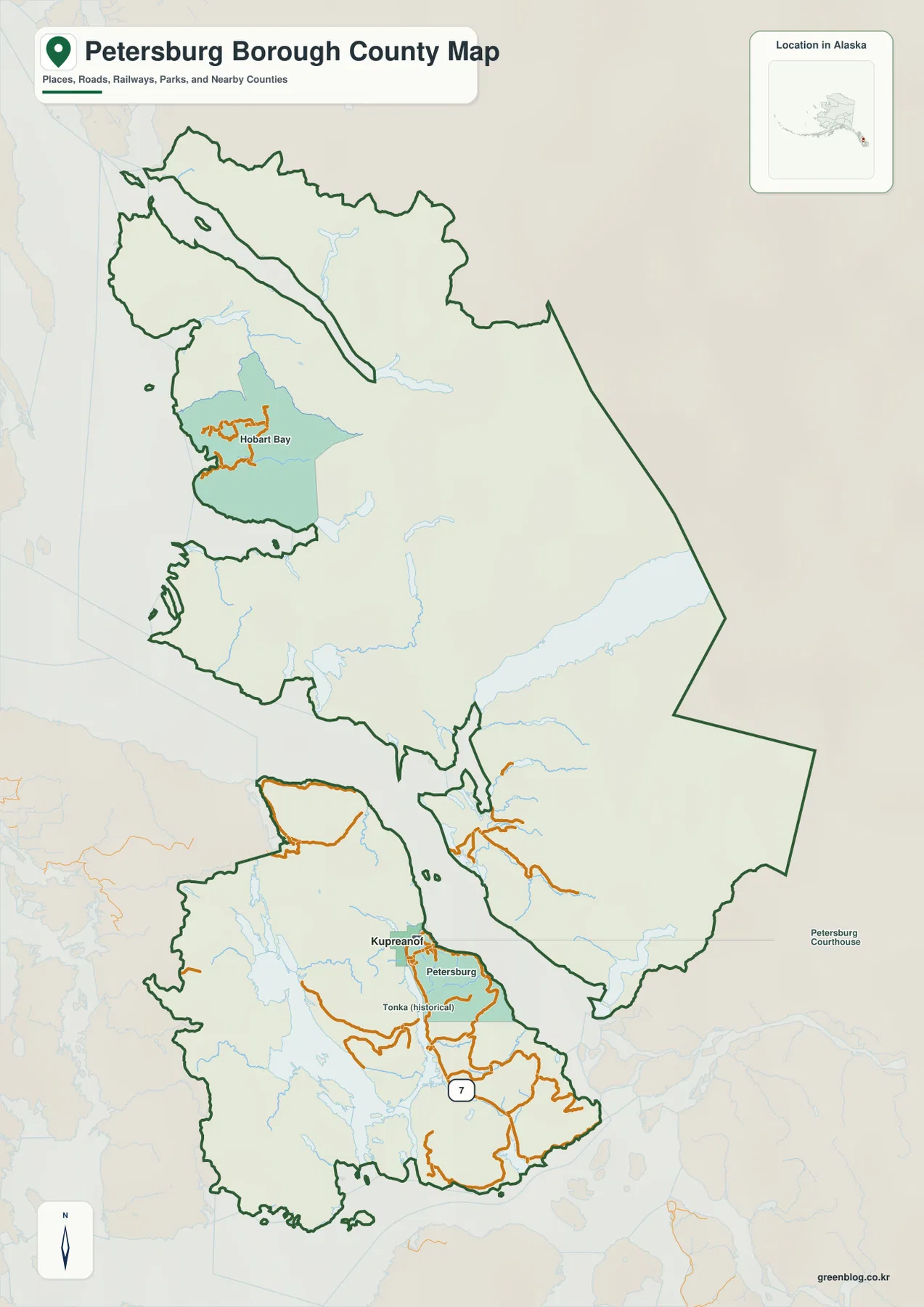
The general map is the best starting point for orientation. Petersburg and Kupreanof appear near one another in the lower portion of the borough, surrounded by a denser set of orange road lines than most of the rest of the map. A Route 7 shield is visible on the southern road system. Farther north, Hobart Bay is labeled in a separate area, while long stretches between the named places contain few road markings. That contrast makes the map useful for explaining where development is concentrated without pretending that the whole borough can be crossed on one road network.
Following the borough outline from south to north also reveals how often water interrupts the land. Large island blocks, narrow channels, and deeply indented shorelines sit inside the same administrative boundary as the mainland mountain country farther east. A reader who looks only at the borough’s land area could miss this geography. On the map, the water separating the southern islands is as important to orientation as the green boundary line itself.
Regional labels on the city map add another layer of context. Juneau City and Borough is shown to the north, Wrangell City and Borough to the west, Prince of Wales-Hyder Census Area toward the southwest, and Hoonah-Angoon Census Area along the western side. These labels are useful for relative direction, not as a road itinerary. Anyone who needs authoritative legal or administrative boundary work should compare this reference map with current U.S. Census Bureau TIGER/Line geography or another official boundary source.
The closeness of the Petersburg and Kupreanof labels deserves a separate note. Petersburg is the principal community name most readers will recognize, while Kupreanof is the incorporated city that remains within the borough. The general map is concerned with recognizable places and roads, so it naturally includes Petersburg. The next map narrows the question to incorporated-city status, which produces a very different-looking index.
Why Kupreanof is the only ranked city on the city-distribution map
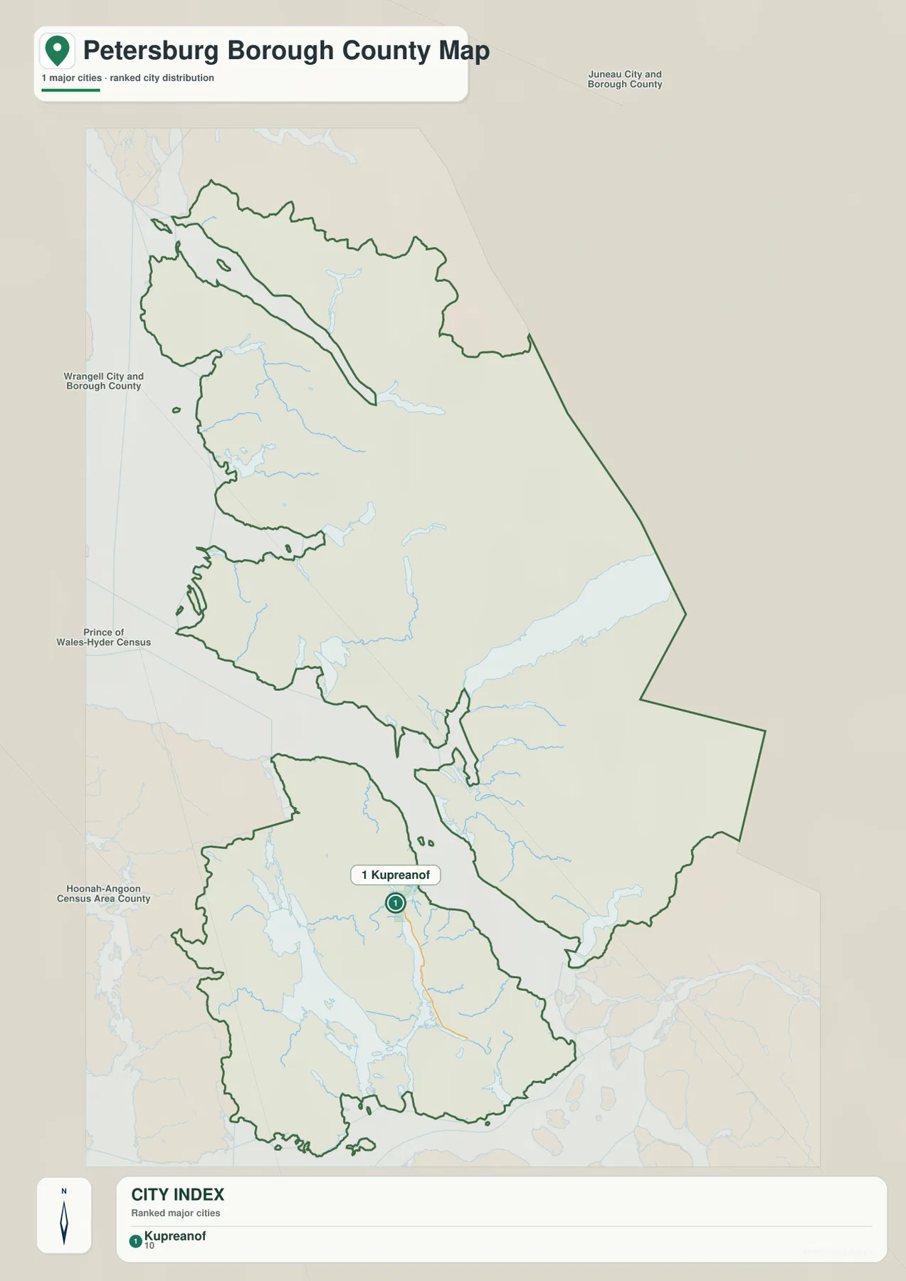
The CITY INDEX at the bottom of this map lists a single place: Kupreanof. That can look surprising because Petersburg is the borough’s best-known community, but the index is based on incorporated-city status. Petersburg Borough’s official Quick Facts explains that the City of Petersburg dissolved when the borough was created in 2013, while the City of Kupreanof remained. The one-city index therefore reflects the current municipal structure rather than suggesting that Petersburg has disappeared as a community.
Kupreanof is plotted in the southern part of the borough close to the Petersburg area. Wrangell Narrows separates the nearby island settings, so two labels that appear almost side by side are still associated with water between them. This is a useful example of why a Southeast Alaska map should not be interpreted like a highway map from an inland county. The visual gap between places is only a location reference and does not tell a traveler which transportation mode is available or how long a trip takes.
The surrounding county-equivalent labels also help place the borough within the larger Southeast Alaska region. Juneau lies to the north, Wrangell to the west, and Prince of Wales-Hyder and Hoonah-Angoon appear on the other sides of the mapped area. The purpose is geographic orientation. The map does not show ferry schedules, flight routes, marine travel times, or a full list of every settlement in the borough, so those questions require other sources.
It is also important not to treat the ranking as a population table. The graphic identifies the incorporated city captured by the map’s city-index rule; it does not compare the size, economic role, or daily activity of Petersburg and Kupreanof. For demographic work, use current population data. For this page, the useful takeaway is simpler: the general map and the city-index map classify place names differently, and understanding that distinction prevents a misleading reading of the map.
Wrangell Narrows connects the settlement story to a much larger network of rivers and passages
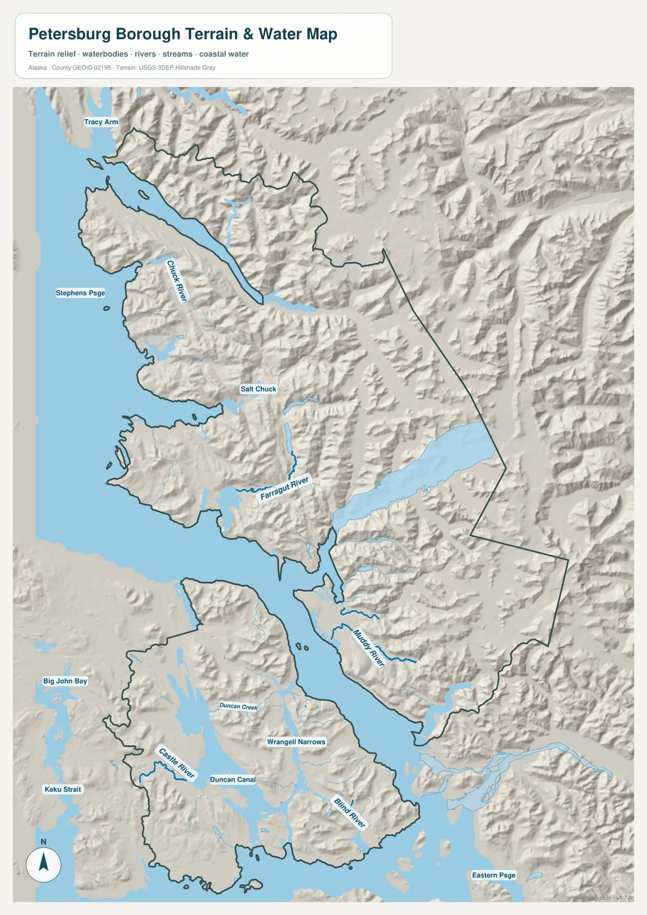
The terrain-and-water map makes the borough’s geography much easier to understand. Wrangell Narrows runs through the southern central area, with Duncan Canal to the west and Blind River on the eastern island section. Nearby labels include Duncan Creek and Castle River. Instead of a single coastline, the map shows water repeatedly dividing and reconnecting the land, especially around the large islands near Petersburg and Kupreanof.
Farther north, Farragut River and Muddy River are labeled in the middle portion of the borough. Chuck River and Salt Chuck appear still farther north, while Stephens Passage forms a major water reference along the western side. Keku Strait is labeled toward the southwest outside the main island mass, and Eastern Passage appears near the southeast edge. These names give the reader fixed points for following a region where the shoreline alone can otherwise become difficult to trace.
The shaded terrain adds another important layer. Ridges and steep valleys reach close to the water in the mainland sections, and the large southern islands also show substantial relief rather than broad flat plains. The map does not provide survey elevations or contour measurements, so it should not be used to assign a precise height to a ridge or valley. It is most useful for seeing the relative relationship between mountainous ground, river valleys, channels, and coast.
Wrangell Narrows is particularly helpful for connecting the water map to the settlement maps. The close Petersburg–Kupreanof area on the general map makes more sense when viewed as a pair of nearby island communities separated by a narrow waterway. Duncan Canal and other channels extend the same pattern farther south and west. This helps explain why a short straight-line separation on a map does not automatically translate into a short drive or a simple land route.
This map is not a nautical chart, flood-hazard map, parcel map, or legal boundary product. It does not provide tide, depth, channel-safety, flood-probability, or evacuation information. Boating, engineering, emergency planning, and property decisions require current purpose-specific official sources. For research that depends on water-feature names and hydrography, USGS National Hydrography is an appropriate companion reference.
Choosing the most useful file for orientation, city status, or water features
Choose the general borough map when the main question is “where are the important named places within the borough?” It combines the boundary, Petersburg, Kupreanof, Hobart Bay, roads, and basic water context in one view. It is the clearest option for a regional overview, a school report, or a presentation slide that needs to establish location before discussing more detailed geography.
Use the city-distribution map when incorporated-city status is the subject. Its single Kupreanof index is meaningful only when the 2013 municipal change is explained: the former City of Petersburg dissolved as the borough formed, while Kupreanof remained incorporated. That makes this version particularly useful for a government or administrative note, but less useful if the reader simply wants a broad list of communities.
The terrain-and-water map is the better choice for Wrangell Narrows, Duncan Canal, Farragut River, Chuck River, Blind River, and the surrounding mountain coast. It contains more physical-geography detail than the other two maps and is the easiest one to use when discussing how islands and waterways shape the borough. Its shaded relief remains a visual reference rather than a precision elevation dataset.
The WebP images in the article are optimized as page previews. For printing, close inspection, or placing the maps into a larger document, the downloadable originals are more practical. The ZIP contains the same three subjects shown here as 2572-by-3638-pixel JPG files. Keeping the original JPGs also makes it easier to zoom into small labels without relying on the reduced-size web preview.
Frequently Asked Questions
Why does the general map show Petersburg while the city index lists only Kupreanof?
When Petersburg Borough was incorporated in 2013, the former City of Petersburg was dissolved and the borough became the local government. The City of Kupreanof remained incorporated within the borough. The general map labels important places such as Petersburg, while the ranked city map applies an incorporated-city rule, which is why Kupreanof is the only entry in its CITY INDEX.
Are Petersburg and Kupreanof connected by the short road distance suggested by the map?
Do not assume that from the map. The two areas appear close because they sit near opposite sides of Wrangell Narrows, but Southeast Alaska travel is strongly affected by islands and waterways. The maps show relative location, not a verified driving route or travel time. Check current local transportation information before planning an actual trip.
Can the terrain-and-water map be used for boating or flood decisions?
No. It is a general geographic reference for the relative positions of channels, rivers, coastline, and terrain. It does not include the depth, tide, navigation, flood-probability, or evacuation information needed for safety decisions. Use current official products designed for those purposes.
Map File Information
The archive contains the Petersburg Borough general map, city-distribution map, and terrain-and-water map as original high-resolution JPG files.
- Included Files: 3 JPG maps
- Printable Size: 2572×3638 pixels each
- Intended Use: Printing, classroom materials, presentations, and regional reference
Related Maps
Sources and References
- Petersburg Borough – Borough Map and Boundary Description: official incorporation date, area figures, and borough boundary materials
- Petersburg Borough – Quick Facts: local government history and the status of Petersburg and the City of Kupreanof
- U.S. Census Bureau TIGER/Line Shapefiles: authoritative U.S. county-equivalent boundary geography
- USGS National Hydrography: official reference for rivers, channels, and other hydrographic features
Green Map creates custom-edited map images using open geographic data sources such as geoBoundaries, Natural Earth, OpenStreetMap, and government open data. These maps are edited visual materials, not raw data files, and are provided for education, documents, presentations, and graphic reference.