Northwest Arctic Borough occupies a vast part of northwestern Alaska, stretching from the Chukchi Sea coast and Kotzebue Sound far into the river-filled interior. The easiest way to understand it is not to begin with highways, because the settlements are widely separated and the region does not function like a road-connected county in the Lower 48. Kivalina sits on the northwestern coast, Kotzebue is positioned beside Kotzebue Sound, and places such as Noatak, Ambler, Kobuk, and Selawik lie along different river systems and lowland corridors. This page explains the borough boundary, a six-place city index, and the terrain-and-water setting. The same map subjects are also available below as a single ZIP download containing three high-resolution A3 JPG files.
Alaska uses boroughs in many areas where other states use counties, so the correct regional name here is Northwest Arctic Borough even though the site groups this page with county-map content. U.S. Census Bureau QuickFacts lists about 35,663 square miles of land area and a 2020 population density of roughly 0.2 people per square mile. Those figures provide useful scale for what the maps show: large stretches of land separate relatively small communities, and settlement names appear as isolated points rather than as a dense chain of towns.
An Alaska Economic Trends profile of the Northwest Arctic region describes 11 communities spread across a very large area and notes the absence of a road system connecting them all. That context matters when reading any of the maps on this page. Two places that appear close on a regional image may still be separated by water, tundra, mountains, or long river corridors, and actual travel can depend on air service, water travel, and seasonal conditions. These maps are best used for geographic orientation—where communities, rivers, coastlines, and broad terrain lie relative to one another—not as driving or transportation-planning maps.
Table of Contents
Kotzebue Sound gives the coast and interior an easy reference point
The western side of Northwest Arctic Borough opens to the Chukchi Sea, while Kotzebue Sound reaches inland along the southwestern part of the borough. Those two bodies of water are the clearest anchors for a first look at the region. Kivalina is well north of Kotzebue on the outer coast. Kotzebue itself lies along the northern side of the sound, Deering occupies a separate southwestern section, and Selawik is farther east where rivers and low country spread toward the sound. Finding the water first makes the scattered place names much easier to organize.
The eastern half of the borough requires a different mental picture. Ambler and Kobuk are far inland, well away from the Chukchi coast, while Noatak sits in the northwestern interior along the river that shares its name. The map therefore covers more than a coastal strip. It reaches from marine shorelines and broad lowlands into river valleys and rugged country toward the north and east. This contrast is one reason a simple list of communities does not explain the borough very well; their positions make more sense when the coast, river corridors, and relief are visible at the same time.
Kotzebue is also a practical orientation point because borough administration is centered there and the name is easy to locate beside Kotzebue Sound. It should not be mistaken for the geographic center of the borough, however. Kivalina is far to the northwest, Deering is separated to the southwest, and Ambler and Kobuk are deep in the eastern interior. Starting at Kotzebue and then looking outward in those directions gives a quick sense of just how widely the communities are distributed.
From Kivalina and Noatak to Ambler and Kobuk, the boundary spans a huge distance
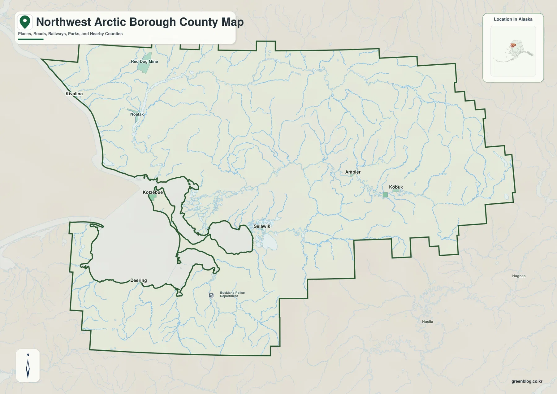
The general boundary map is the clearest choice when the goal is to understand the borough as one administrative area. The green outline surrounds an enormous shape that reaches from Kivalina on the northwestern coast to Ambler and Kobuk in the eastern interior. Kotzebue, Noatak, Selawik, and Deering occupy very different parts of that outline. The result is not a compact cluster of settlements around one urban center; it is a broad collection of coastal and river communities separated by large areas of sparsely populated land.
Red Dog Mine is labeled in the northwestern part of the map and can serve as a useful reference when locating the large area between Kivalina and Noatak. The symbol should be treated only as geographic context. It does not show ownership, operating limits, access rules, or the status of roads associated with the mine. The borough line likewise provides a regional overview rather than a parcel or legal survey boundary. For work that depends on authoritative current boundaries, U.S. Census Bureau TIGER/Line geography or another official boundary source should be checked directly.
Blue waterways appear throughout the map and are much more visually continuous than any region-wide road pattern. Numerous tributaries descend from the north and east toward larger rivers, lowlands, and coastal water. That does not mean the map can tell you which waterways are navigable or how people travel at a particular time of year. It does show why river names are so useful for orientation. Noatak is easier to place when the Noatak River is considered with it, while Ambler and Kobuk make more sense when viewed within the Kobuk River corridor.
The surrounding labels also help establish regional context. North Slope Borough lies to the north, Nome Census Area is on the western side, and Yukon-Koyukuk Census Area is toward the east. These labels are secondary to the Northwest Arctic boundary, but they help readers unfamiliar with Alaska see where the borough sits within the state. They should not be read as a complete map of those neighboring areas; their purpose here is simply to provide direction and context.
Six numbered places make the settlement pattern easier to compare
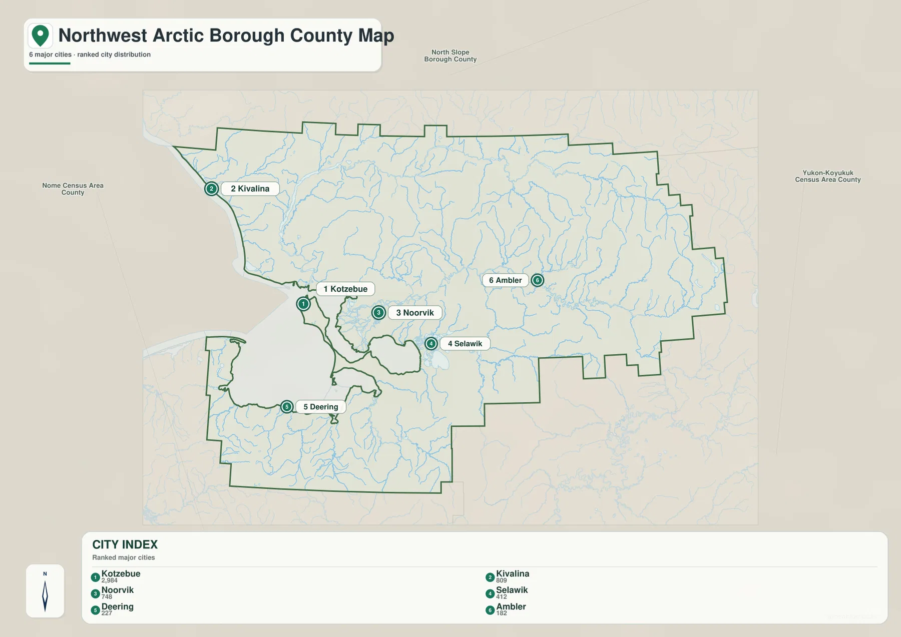
The city-location map highlights six places: Kotzebue, Kivalina, Noorvik, Selawik, Deering, and Ambler. The numbers are an index for finding the labels quickly, not a travel sequence or administrative ranking. Kotzebue sits beside Kotzebue Sound, Kivalina is far north on the Chukchi Sea coast, and Noorvik lies east of Kotzebue in the river-and-lowland country. Selawik appears farther southeast, Deering is separated on the southwestern side of the borough, and Ambler is deep in the eastern interior.
Putting those six markers on one image makes the borough’s settlement pattern immediately visible. Kivalina and Ambler are close to opposite ends of the mapped region, while Deering occupies a section that feels detached from the other numbered places around Kotzebue Sound. Kotzebue, Noorvik, and Selawik may appear to form a looser southwestern group, yet they are associated with different waterways and are still separated by substantial distances. For a classroom slide or regional profile, the numbered map communicates that dispersion more effectively than a text list of names.
The six-place index is not a complete inventory of Northwest Arctic Borough communities. The Alaska Economic Trends profile describes 11 communities in the region, and the general map also labels places such as Noatak and Kobuk that are not included in the numbered city panel. Use the city map when the goal is to compare the selected six quickly. Use the broader boundary map when the full settlement context matters or when a place outside the six-item index needs to be located.
It is equally important not to read the numbered positions as a road map. The communities are not joined by one conventional road network, and straight-line separation on the screen does not translate into a predictable driving time. Actual access can involve aircraft, water travel, winter routes, weather, and other local conditions. Anyone planning a trip or shipment should use current local transportation information; this map should remain a reference for location and relative direction.
Noatak, Kobuk, and Selawik rivers reveal the physical landscape
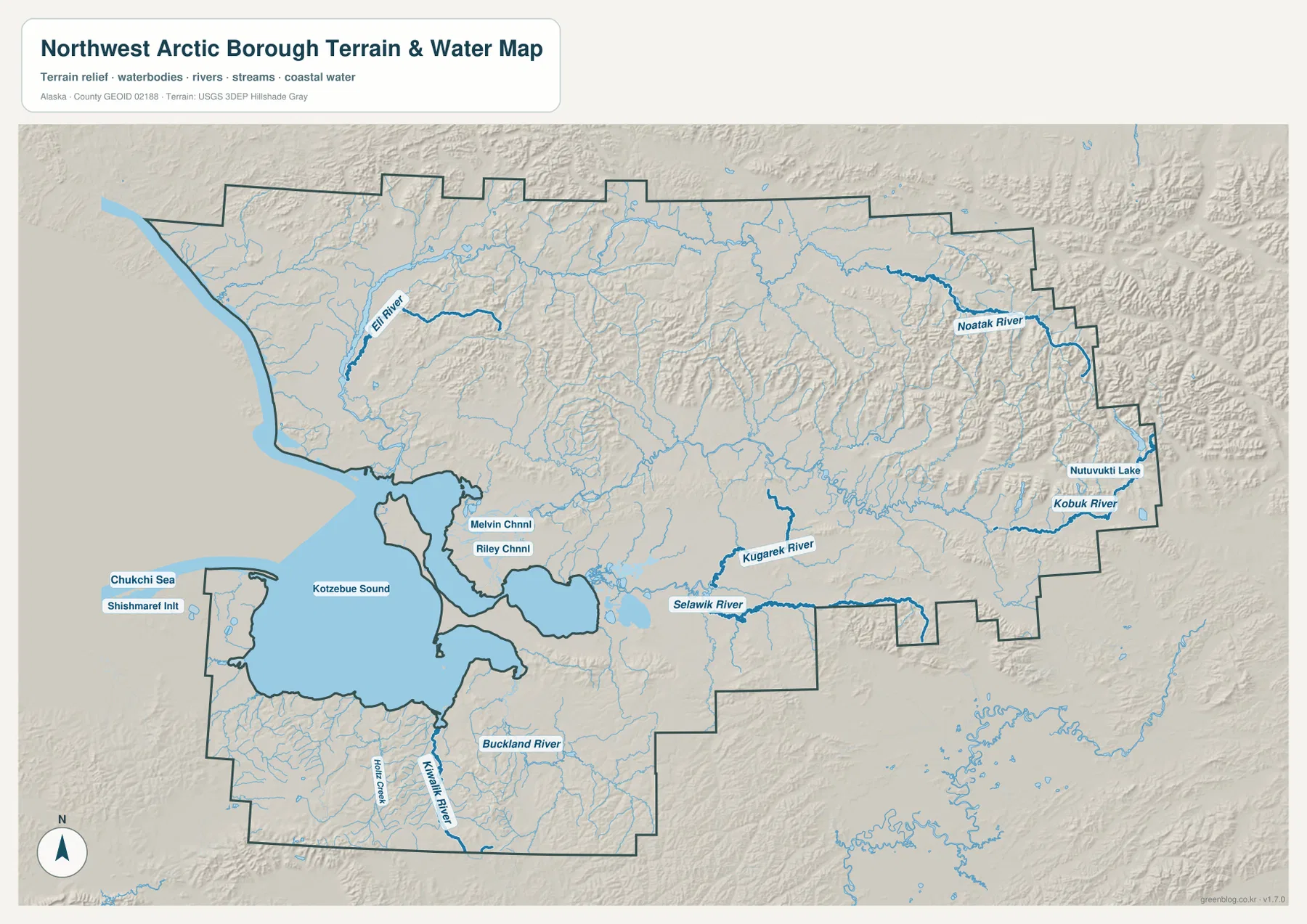
The terrain-and-water version changes the emphasis from settlement labels to the physical framework of the borough. The Noatak River forms a major line across the north, the Kobuk River crosses the eastern interior, and the Selawik River runs through the lower country to the south of the Kobuk system. Farther south, the Buckland and Kiwalik rivers are also labeled, while Kotzebue Sound and the Chukchi Sea define the western side. Seeing these features together explains why river valleys and coastal water are such useful reference points for locating communities.
The Noatak River is especially useful for orienting the northern part of the borough. The National Park Service describes the river as a major Arctic waterway flowing westward from the Brooks Range region, and the map shows it crossing rugged country before approaching the lower western landscape. The community of Noatak is therefore easier to understand as a river-valley settlement than as an isolated dot in the northwestern interior. The many tributaries around the main channel also show that this is not an empty blank space between communities but a heavily dissected drainage landscape.
The Kobuk River provides a similar reference for Ambler and Kobuk in the east. Shaded relief is stronger in this part of the map than around much of Kotzebue Sound, and the river follows a broad valley through more rugged terrain. National Park Service information on the Kobuk River describes its westward flow from the interior, which matches the large-scale direction visible here. Looking at the city map first and then switching to the water map makes the eastern communities easier to place within a real river corridor rather than simply labeling them as “far inland.”
South of the Kobuk system, the Selawik River enters a much flatter and wetter setting. Around the eastern side of Kotzebue Sound, water channels and lowlands become more complex; the map labels features such as Melvin Channel and Riley Channel in this area. The U.S. Fish & Wildlife Service description of Selawik National Wildlife Refuge discusses the Selawik drainage, wetlands, and the Kobuk River delta environment, providing useful background for the broad low country seen on the map. This helps explain why Selawik’s position looks very different from Ambler’s even though both are inland from the open Chukchi coast.
The shaded terrain is intended to make broad landform differences visible, not to provide survey-grade elevations. The north and east contain more pronounced mountain and valley relief, while the country around Kotzebue Sound and Selawik includes larger areas that appear lower and flatter. Likewise, the water lines are geographic references, not current information about depth, ice, flood probability, tides, or navigability. Flood planning, marine travel, engineering, and legal decisions require current purpose-specific data from USGS, NOAA, the borough, or other responsible agencies.
Choosing a map for printing, place checks, or river context
Use the general borough map when your first question is where the major places sit within the administrative boundary. It keeps Kivalina, Noatak, Kotzebue, Ambler, Kobuk, Selawik, and Deering in one view and makes the full west-to-east extent easy to explain. This is the most straightforward version for a regional overview, a school report, or a presentation slide where the audience needs to see the borough’s size before focusing on any one river or settlement.
The numbered city map is better when the selected six population centers are the subject. Kotzebue, Kivalina, Noorvik, Selawik, Deering, and Ambler can be found quickly without searching through a dense set of labels, and the spacing between the markers is easy to compare. If Noatak, Kobuk, or another community outside the six-item index must be included, pair this version with the general boundary map rather than treating the city index as a complete list.
Choose the terrain-and-water map when rivers or landforms are central to the task. It is the clearest supplied version for following the Noatak, Kobuk, Selawik, Buckland, and Kiwalik rivers and for seeing how rugged northern and eastern terrain differs from the lower country around Kotzebue Sound. It is particularly useful when explaining why a community belongs to a specific river corridor or why locations that seem close on a simple outline map are separated by complex physical geography.
The WebP images in the article are optimized for convenient on-screen viewing. For printing or close inspection, use the original files in the download archive. The ZIP contains the general boundary map, the six-place city-location map, and the terrain-and-water map as high-resolution A3 JPG images, each measuring 3638 by 2572 pixels. Those larger files are better when labels need to be enlarged, a clean printout is required, or a map is being placed into personal study notes, classroom material, or a presentation.
Frequently Asked Questions
Does the six-place city map include every community in Northwest Arctic Borough?
No. The numbered index highlights Kotzebue, Kivalina, Noorvik, Selawik, Deering, and Ambler for quick comparison. The Alaska Economic Trends profile describes 11 communities in the region, and the general map includes additional names such as Noatak and Kobuk. Use the city map for the selected six places and the boundary map when you need broader settlement context.
Which map should I use to compare the Noatak and Kobuk rivers?
The terrain-and-water map is the best choice because it emphasizes both rivers along with the Selawik River, Kotzebue Sound, tributaries, and shaded landforms. It makes the northern Noatak system and the eastern Kobuk valley easy to compare. Keep the general map beside it if you also need the broader community labels and full administrative outline.
Can I use these maps to plan a driving route between borough communities?
No. The communities are not connected by one conventional road network, and map distance does not translate into a reliable driving time. Travel can depend on air service, water routes, seasonal conditions, and other local factors. Use these maps for geographic orientation, then consult current local transportation information for an actual trip or shipment.
Map File Information
The ZIP archive includes the Northwest Arctic Borough boundary map, city-location map, and terrain-and-water map as the original high-resolution A3 JPG files.
- Included Files: 3 high-resolution JPG maps
- Printable Size: 3638×2572 pixels each
Related Maps
Sources and references
- Northwest Arctic Borough official website: official borough administration and regional information
- U.S. Census Bureau QuickFacts – Northwest Arctic Borough: official land-area, population, and density statistics
- Alaska Economic Trends – Northwest Arctic: State of Alaska profile covering community distribution and transportation context
- National Park Service – Noatak River: official background on the Noatak River and its Arctic setting
- National Park Service – Kobuk River: official background on the Kobuk River and river-valley setting
- U.S. Fish & Wildlife Service – Selawik National Wildlife Refuge: official information on the Selawik drainage, wetlands, and Kobuk River delta environment
Green Map creates custom-edited map images using open geographic data sources such as geoBoundaries, Natural Earth, OpenStreetMap, and government open data. These maps are edited visual materials, not raw data files, and are provided for education, documents, presentations, and graphic reference.