Wabash County stretches from North Manchester and the Eel River country in the north to La Fontaine and the Mississinewa River side in the south. Wabash sits slightly south of center, with Roann to the west and Lagro to the east. The road map shows a network of numbered routes linking those places, while the physical maps reveal several distinct river valleys and higher hill country toward the east and southeast. This Wabash County Indiana Map page brings those roads, towns, rivers, lakes, and elevation differences together. Below, you can download Wabash County’s four 2572×3638 high-resolution JPG originals in one ZIP for close inspection or A3 printing.
Wabash and North Manchester are the most useful fixed points. Routes 13, 15, and 24 meet around the Wabash area, while Route 114 crosses North Manchester and Route 175 extends south from the northern road network. Roann is easier to place from Route 16, Lagro sits east of Wabash near Routes 355 and 524, and La Fontaine lies farther south along the Route 13 side. The county’s long shape becomes obvious once those communities are placed from north to south.
The elevation image shows a county with much more relief than the road grid suggests. Its legend reports an actual range of about 154 to 282 meters and a mean of 242 meters. Green low corridors follow Eel River in the north, Wabash River through the central-east, and Mississinewa River along the southern edge. Broad tan and brown hills rise across the east and southeast, with additional high ground in the northwest.
Table of Contents
Wabash connects the central road network to towns in every direction
Wabash is the clearest starting point on the general county map. Route 13 continues south from the city, Route 15 approaches from the northwest, and Route 24 enters from the west. The Wabash Police Department label also provides an easy landmark. Once those three routes are fixed, Lagro, Roann, La Fontaine, and the smaller interior places become much easier to organize.
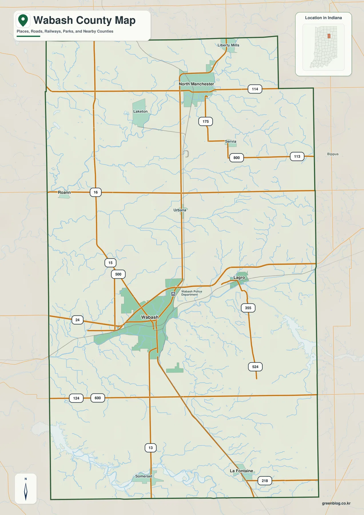
North Manchester lies near Route 114, with Route 175 extending south through the northern interior. Liberty Mills and Servia appear nearby, while Urbana provides a central place reference on the road toward Wabash. This part of the county has a wider road spacing than the Wabash area and sits close to the Eel River valley.
Roann is easy to locate from Route 16 on the western side, with Laketon farther north. Route 15 bends south of Roann toward the Wabash area. Lagro, on the opposite side of the county, lies near Routes 355 and 524. These two communities make a useful west–east pair around the county’s central city.
La Fontaine lies farther south along the Route 13 corridor, while Somerset is labeled near the southern boundary. The general map is useful for county-scale orientation, named places, and route directions. Temporary construction, closures, and changing travel restrictions should be checked with a current transportation source.
Four direct-distance links show how far the main towns sit from Wabash
The city-connections view uses Wabash as the hub. North Manchester is shown about 14 miles north, La Fontaine about 11 miles south, Roann about 9 miles northwest, and Lagro about 6 miles east. These are direct distances, not driving mileage, so they are best used to compare direction and spacing rather than plan a road trip.
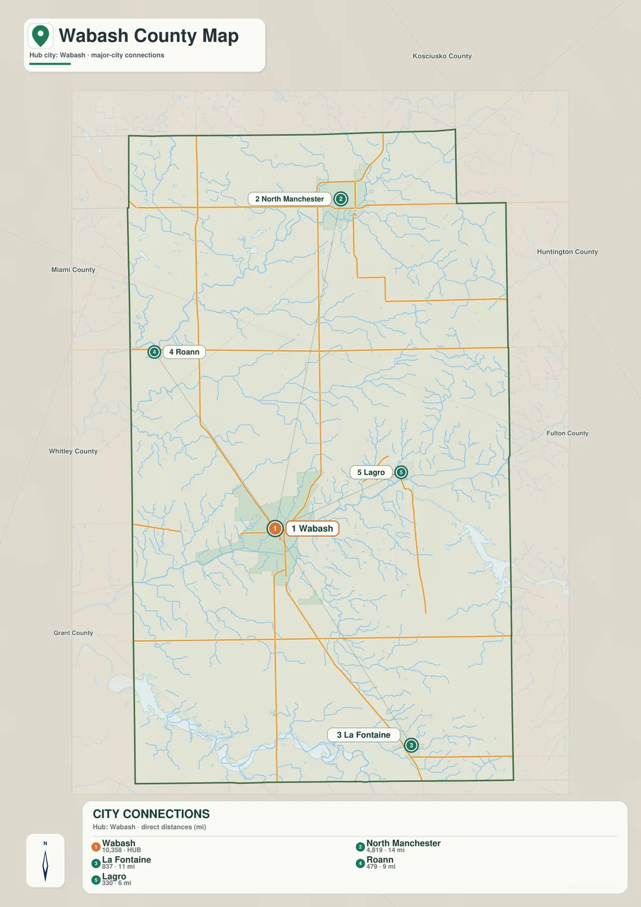
Lagro is the closest of the four highlighted places and sits within the same broad Wabash River side of the county. North Manchester is the farthest and belongs to the Eel River country in the north. Roann and La Fontaine point toward separate western and southern parts of the county, which makes the connection view useful for understanding the county’s full extent.
The city graphic also prints small numeric values beside the place names, but the supplied package does not identify a statistical year or separate source for those figures. This page therefore does not present them as current official population. A recent U.S. Census release should be used when current population counts are needed.
Kosciusko, Huntington, Fulton, Grant, Whitley, and Miami counties are labeled around the outside of the map. Those surrounding names help explain why North Manchester, La Fontaine, and Roann face different neighboring counties even though they all belong to Wabash County.
Eel River, Wabash River, and Mississinewa River occupy separate valleys
Eel River is the dominant northern water feature. It enters from the northwest, bends repeatedly across the upper county, and passes south of the North Manchester area. Silver Creek joins the northwestern water network, while Brown Lake, Lukens Lake, Long Lake, and Round Lake provide separate small-water references around the Eel River side.
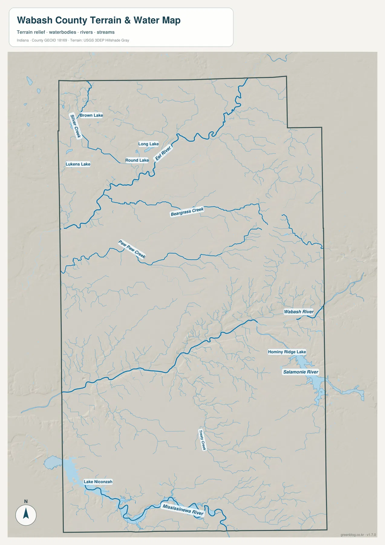
Beargrass Creek crosses the middle of the county from west to east, while Paw Paw Creek follows a separate route farther south. On the eastern side, Wabash River becomes the main reference, with Hominy Ridge Lake and Salamonie River nearby. These channels occupy different valleys rather than one continuous drainage line.
Treaty Creek runs through the south-central interior, and Mississinewa River forms a major low corridor near the southern boundary. Lake Niconzah is labeled in the southwest and provides a compact water reference near that river system. Comparing the northern Eel River with the southern Mississinewa River makes the county’s multiple river valleys easy to see.
Use this water view to locate Wabash County rivers, creeks, and lakes at county scale. Do not use this Wabash County water overview to set flood limits, parcel boundaries, legal water lines, water depth, or navigation conditions; those questions require the current agency records created for them.
The 154–282 meter surface drops into several deep river corridors
The elevation legend gives Wabash County an actual range of about 154 to 282 meters and a mean of 242 meters. The strongest green lowlands follow Wabash River through the central-east, Eel River across the north, and Mississinewa River in the south. Higher tan and brown terrain becomes extensive across the east and southeast, with another broad high area in the northwest.
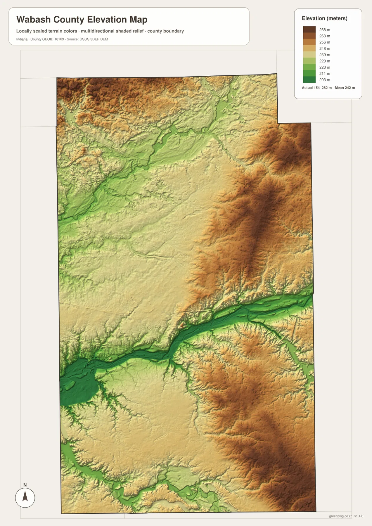
Eel River cuts a broad low path through the northern high ground. The northwest is elevated overall, but stream valleys break the surface into ridges and hollows. North Manchester lies close to this low river corridor, which is easy to match between the water and elevation maps.
The central-east contains an even stronger contrast around Wabash River. Dark green valley ground sits immediately beside long brown ridges to the east. In the south, Mississinewa River creates another major low corridor, while the southeastern interior rises sharply above it.
The relief image is intended for broad comparison across Wabash County rather than surveyed point elevations. For an exact elevation at a Wabash County building, road point, field, or parcel corner, use the underlying elevation dataset or a professional survey instead of this countywide relief image.
Keep Wabash fixed while comparing roads, rivers, and elevation
For basic orientation, start with Wabash and Routes 13, 15, and 24. The city-connections view is cleaner when the question is how North Manchester, La Fontaine, Roann, and Lagro are positioned around the hub. Once those directions are familiar, Urbana, Servia, Laketon, and the smaller road network become easier to place.
For the physical landscape, find Eel River, Wabash River, and Mississinewa River before moving to Beargrass and Paw Paw creeks. Open the elevation map at the same locations and the relationship becomes clear: the main rivers occupy green low corridors, while higher eastern and southeastern terrain rises around them.
The page uses smaller WebP previews for quick browser viewing. For Wabash County, the ZIP preserves four full-resolution JPG originals—general county, city-connections, terrain-and-water, and elevation—at 2572 by 3638 pixels each. Those Wabash County originals keep more detail for A3 output and for zooming in on route numbers, creek names, and the smaller lake labels.
A practical comparison routine is to keep Wabash fixed, locate the main roads, trace the Wabash River valley, then move north to Eel River and south to Mississinewa River before comparing the green valleys with the higher brown uplands.
Frequently Asked Questions
Are the 14-, 11-, 9-, and 6-mile labels from Wabash driving distances?
No. The city-connections map shows direct distances from Wabash: about 14 miles to North Manchester, 11 miles to La Fontaine, 9 miles to Roann, and 6 miles to Lagro. Actual driving mileage can be longer because roads do not follow the straight connection lines exactly.
Are Eel River and Wabash River the same river?
No. Eel River crosses the northern part of the county, while Wabash River occupies a separate central-eastern valley. Mississinewa River and Salamonie River are also mapped as distinct waterways.
Where does the elevation map show the highest-looking terrain?
Higher tan-brown terrain is widespread in the east and southeast, with another elevated area in the northwest. The main river corridors are much lower. The legend reports an actual elevation range of about 154–282 meters and a mean of 242 meters.
Map File Information
The ZIP contains the high-resolution JPG originals for the Wabash County general, city-connections, terrain-and-water, and elevation views. Choose these files when you need to enlarge route numbers, creek labels, or prepare an A3 print.
- Printable Size: 2572×3638 px each
Related Maps
Sources and References
The place, road, water, and elevation descriptions above are based on the supplied Wabash County maps and asset information. The references below point to official boundary, water, and elevation sources for readers who need more detailed Wabash County source data.
- U.S. Census Bureau TIGER/Line Shapefiles – official geometry for county boundaries, roads, and named places
- USGS National Hydrography – source information for Wabash County rivers, creeks, and mapped inland waters
- USGS 3D Elevation Program – elevation-source information for the county relief surface
Green Map creates custom-edited map images using open geographic data sources such as geoBoundaries, Natural Earth, OpenStreetMap, and government open data.
These maps are edited visual materials, not raw data files, and are provided for education, documents, presentations, and graphic reference.