Adams County is easiest to understand on the supplied maps by starting with Decatur and following the county south through Monroe, Berne, and Geneva. Decatur forms the main northern hub on the road map, while the other three communities are spaced along a broad north–south corridor. The waterways and elevation maps add a different layer: the St. Marys River and several creeks cut through the county, and the mapped elevation ranges from about 187 to 272 meters. High-resolution JPG versions of every map shown on this page are available in the ZIP download below.
The road network gives the county a strong set of reference points. US 27 and US 33 approach Decatur from the northwestern side of the map, while Route 224 runs west–east through the Decatur area. Farther south, Route 124 crosses near Monroe and Route 218 runs through Berne. Geneva lies closer to the southern edge, where a dense network of small streams becomes more visible. Instead of treating each map as a separate list of symbols, it is more useful to follow these places and then compare how roads, waterways, and terrain change around them.
The elevation map shows that Adams County is not uniformly flat. A long low corridor appears from the north-central part of the county toward the east, and other low ground follows southern waterways. Higher colors are more common in the southwest and southeast, with additional elevated ground in the northeast. The water map helps explain that pattern by showing the St. Marys River, Yellow Creek, Blue Creek, and the Wabash River along with smaller ditches, creeks, and lakes. Together, the maps make the county’s settlement pattern and physical setting much easier to compare.
Table of Contents
Decatur as the Northern Hub and the Road Chain South to Geneva
On the general county map, Decatur has the largest developed area and the densest cluster of labeled roads. US 27 and US 33 enter from the northwest and converge on the city area, while Route 224 approaches from the west. Roads labeled 650 and 400 continue east of Decatur, and another route angles southeast toward Pleasant Mills. The map also marks the Adams County Sheriff’s Office and Adams County Emergency Medical facilities near Decatur, providing additional landmarks for locating the city within the county outline.
South of Decatur, Monroe appears near the middle of the county where Route 124 runs east–west. Berne is farther south and is crossed by Route 218, while Geneva sits close to the southern end of the county. This sequence makes the county’s elongated shape easy to recognize: the main named communities are distributed through the center rather than concentrated only at one corner. Route 101 is visible toward the eastern side, and Route 116 appears near the southwestern part of the map, adding cross-county reference lines away from the central chain.
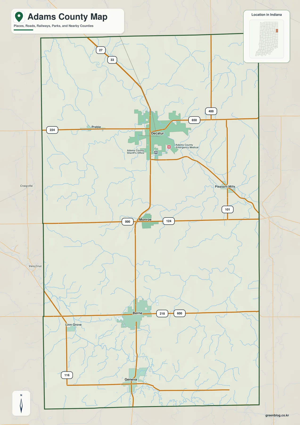
Places just outside or near the edge of the county also help establish orientation. Craigville and Vera Cruz are labeled west of the county, Linn Grove appears near the southwestern side, and Pleasant Mills is shown east of the Decatur-to-Monroe portion of the map. These labels are useful when checking where the county boundary ends and how the road network continues beyond it. The map is designed for county-wide orientation, however, not turn-by-turn driving directions or real-time road conditions.
A practical way to use this map is to remember one main road near each central community. Decatur is associated with the US 27/33 and Route 224 area, Monroe with Route 124, and Berne with Route 218. Geneva lies farther south near several streams. Once those anchors are clear, smaller roads and waterways become much easier to place without having to read every label at once.
Straight-Line Spacing from Decatur to Monroe, Berne, and Geneva
The city-connections map removes much of the road detail and uses Decatur as the hub. It shows Monroe about 6 miles from Decatur, Berne about 12 miles away, and Geneva about 16 miles away. Those are direct, straight-line distances between the mapped points, not driving distances along roads. Actual trips will follow the road network and can therefore be longer. The simplified distance labels are most useful for comparing the relative spacing of the communities.
The arrangement is nearly vertical on the page, but the towns do not sit on one perfectly straight line. Monroe is south of Decatur, Berne is farther south, and Geneva is close to the county’s southern end. The map also labels neighboring Allen County to the north, Wells County to the west, and Jay County to the southwest. That wider frame helps show how Adams County fits among nearby counties while keeping the four principal mapped communities easy to see.
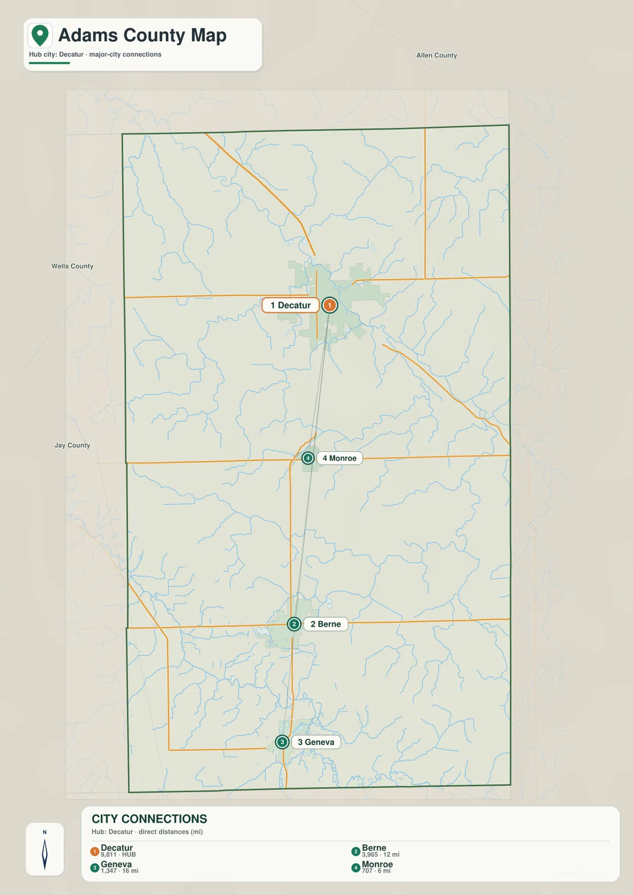
The labels beside the towns also include reference numbers, but this page does not treat those figures as current official population totals. The value of the city map is its clear geometry: a reader can see at a glance which community is farther south and how the distances grow from the Decatur hub. For current demographic data, a separate official statistics source should be used rather than reading population conclusions from a map made primarily for location comparison.
For trip planning, the city map and general map work best as a pair. The city map answers the simple question of relative direction and straight-line spacing, while the general map restores the actual labeled roads that connect the area. This prevents a common mistake of treating a direct map distance as if it were the mileage a driver would travel.
St. Marys River, Blue Creek, and the Southern Wabash River Edge
The terrain-and-water map brings the county’s drainage network into focus. The St. Marys River is the most prominent labeled river in the east-central part of the county, and Yellow Creek joins the river system nearby. Farther north, multiple small channels spread across the map, while Saddle Lake is marked as a distinct water body in the northern half. With most road detail removed, it becomes easier to follow the branching pattern of creeks and ditches across the county.
Blue Creek becomes the main labeled waterway in the middle-southern portion of the map. Little Blue Creek appears farther east, and Rainbow Lake is labeled closer to the southern end. At the bottom of the county, the Wabash River is shown as a broader, darker water line. These features make clear that Adams County contains several separate stream corridors rather than one single channel running through the entire county from north to south.
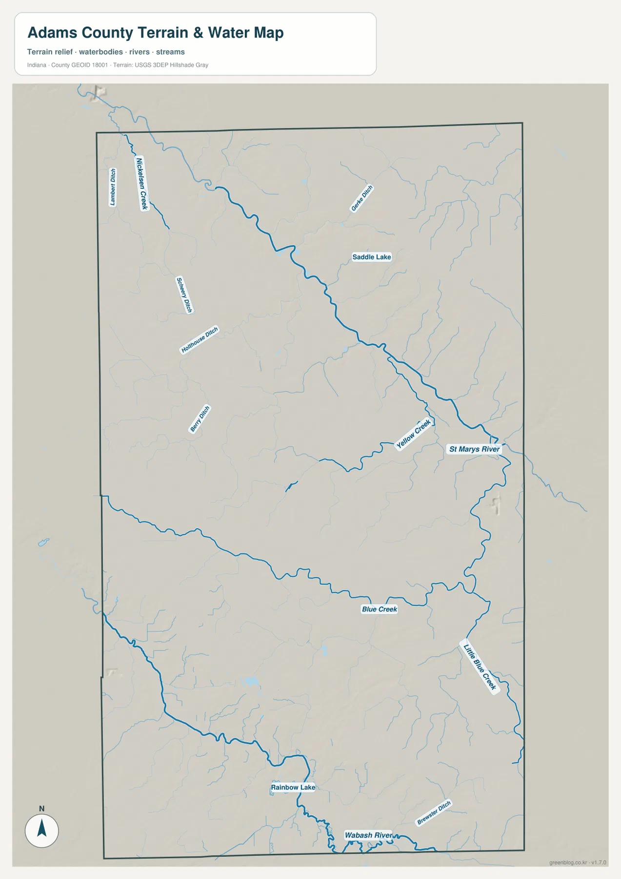
Several of the larger water corridors correspond to lower areas on the elevation map. The connection is especially noticeable where the green lowlands form long narrow bands through otherwise higher terrain. That comparison is useful for understanding why the terrain surface is not a single smooth plain. Streams and rivers occupy lower corridors that cut across the broader upland areas.
This is a reference map for relative water locations, not a flood-hazard, navigation, parcel, or legal-water-boundary map. It does not establish water depth, current flow conditions, or property rights. Anyone who needs flood risk, stream status, or engineering information should use the appropriate current official source. For this page, the water map is best used to identify named rivers, creeks, lakes, and their relationship to the county’s terrain.
187–272 m Relief: Low River Corridors and Higher Southern Ground
The elevation map gives an actual county-wide range of about 187 to 272 meters, with a mean elevation of about 252 meters. Although the county does not look mountainous, the color changes show meaningful local relief. The lowest areas appear as dark green bands, especially along the north-central to eastern corridor and in parts of the south where waterways cut through the landscape. Much of the central area sits at intermediate elevations shown in green to yellow-green tones.
Higher ground is much more visible in the southwest and southeast, where broad brown and tan areas rise above the central lowlands. The northeast also contains elevated terrain compared with the long green valley through the northern half. Small stream valleys cut into these higher areas, producing branching lower lines that match many of the waterways on the separate water map. Looking at both maps together makes the relief easier to interpret than reading the elevation colors by themselves.
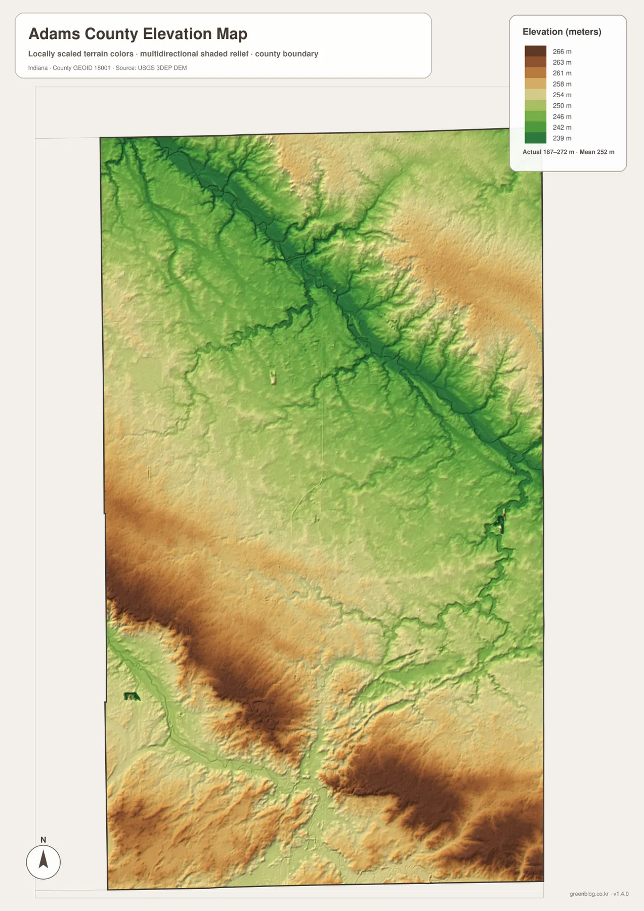
The low corridors also explain why a water-only view and a road-only view can feel different. Roads often cross the county in comparatively straight lines, while rivers and creeks bend through the lower terrain. Around the St. Marys River system and the southern watercourses, the elevation colors follow the valleys rather than the road grid. That distinction is useful when a reader wants to understand the physical setting behind the settlement and transportation pattern.
The elevation surface is generalized for county-scale comparison. It should not be treated as a survey-grade measurement for a specific property, building site, drainage project, or road design. For engineering or legal work, a higher-resolution official elevation source or field survey is necessary. On this page, the map is intended to show the broad 187–272 meter range and the contrast between stream valleys and higher ground.
Choosing the Best Map and Downloading the High-Resolution JPG Files
Use the general county map when the question is about roads, named places, county limits, and how Decatur, Monroe, Berne, and Geneva fit together. It contains the richest set of labels and is the best first map for orientation. Use the city-connections map when the main goal is to compare the four central communities without the distraction of many smaller features. Its straight-line distance labels make the spacing from Decatur particularly easy to understand.
For rivers, creeks, and lakes, the water map is clearer because the blue network is emphasized and most transportation detail is removed. The elevation map answers a different question: where the terrain is lower or higher across the county. Comparing those two maps reveals how the St. Marys River, Blue Creek, the Wabash River, and smaller waterways occupy lower corridors through the surrounding terrain.
The WebP images on this page are sized for convenient online viewing. The downloadable ZIP contains the corresponding original JPG files at 2572 × 3638 pixels each, making them better suited to close inspection and printing. The archive includes the general county map, city-connections map, terrain-and-water map, and elevation map. These are reference maps for geographic orientation and should not replace legal boundary surveys, flood determinations, or engineering documents.
Frequently Asked Questions
Which map is best for comparing Decatur, Monroe, Berne, and Geneva?
The city-connections map is the simplest choice if you only need relative direction and spacing. It shows Monroe about 6 miles, Berne about 12 miles, and Geneva about 16 miles from Decatur as straight-line distances. If you also need to see the labeled roads, use the general county map alongside it. The direct distances are not driving mileage, so travel planning should use current road information.
What are the main waterways labeled on the Adams County maps?
The water map prominently labels the St. Marys River, Yellow Creek, Blue Creek, Little Blue Creek, and the Wabash River, along with Saddle Lake and Rainbow Lake. Smaller creeks and ditches are also shown. The map is useful for location comparison, but it is not intended to determine flood risk, water depth, navigation status, or legal water boundaries.
Are the downloaded maps larger than the images displayed on the page?
Yes. The page uses WebP images for faster online viewing, while the ZIP contains the corresponding JPG originals at 2572 × 3638 pixels each. The larger files are better for zooming into road and stream labels or for printing. They remain county-scale reference maps rather than survey-grade or engineering documents.
Map File Information
Download the high-resolution JPG originals for the Adams County general map, city-connections map, terrain-and-water map, and elevation map shown on this page.
- Included Files: 4 high-resolution JPG maps
- Printable Size: 2572 × 3638 px each
Related Maps
Sources and References
- Adams County, Indiana Official Website – county government and local information
- Decatur-Adams County Parks & Recreation – local parks and outdoor recreation information
- U.S. Census Bureau TIGER/Line Shapefiles – county boundary, road, and place reference data
- USGS National Hydrography – river, stream, and waterbody reference data
- USGS 3D Elevation Program – elevation reference data
Green Map creates custom-edited map images using open geographic data sources such as geoBoundaries, Natural Earth, OpenStreetMap, and government open data.
These maps are edited visual materials, not raw data files, and are provided for education, documents, presentations, and graphic reference.