You can download four high-resolution JPG maps of Lawrence County, South Dakota, in one ZIP file from this page. Lawrence County occupies the western edge of South Dakota in the northern Black Hills, and the contrast between the broad Spearfish area and the steep Deadwood–Lead country is visible across every supplied map. Roads spread more openly around Spearfish, while farther south they bend through narrow valleys; creeks become more deeply incised; and elevation rises sharply into the central and southwestern hills. Reading the maps around a few familiar places makes that change much easier to follow.
The Lawrence County history page identifies Deadwood as the county seat and describes a county bordered by Wyoming on the west, Butte County on the north, Meade County on the east, and Pennington County on the south. On the supplied maps, Spearfish is the strongest northern settlement, Whitewood and St. Onge help define the east and northeast, and Deadwood, Lead, and Central City sit inside the more rugged interior. Those positions are useful because the county is not organized around one uniform landscape. Settlement, highways, creek valleys, and elevation all change together as you move from the northwestern low country into the Black Hills high terrain.
Table of Contents
Spearfish opens onto wider northern roads while Deadwood and Lead sit in tighter mountain terrain
Spearfish is the easiest place to orient yourself on the general county map. I-90 and US 14 pass through the northern part of the county, with North Spearfish just above the main city area and Mountain Plains to the south. Eastward, the road network leads toward St. Onge and Whitewood, and the map also shows Belle Fourche and Sturgis outside the county as useful regional references. Compared with the roads farther south, this northern network has longer, more open segments and fewer of the tight bends that dominate the mountain valleys.
Deadwood and Lead occupy a very different setting. Deadwood is surrounded by curving roads that converge in a confined valley, Lead lies immediately to the south, and Central City is part of the same interior cluster. Crook City and Boulder Canyon help orient the eastern side of this mountain area, while US 85 enters from the southwest and US 385 crosses the southeastern part of the county. The county outline itself reinforces the sense of a varied landscape: the north edge is irregular, the west meets Wyoming, and the southeastern portion steps outward rather than forming a simple rectangle.
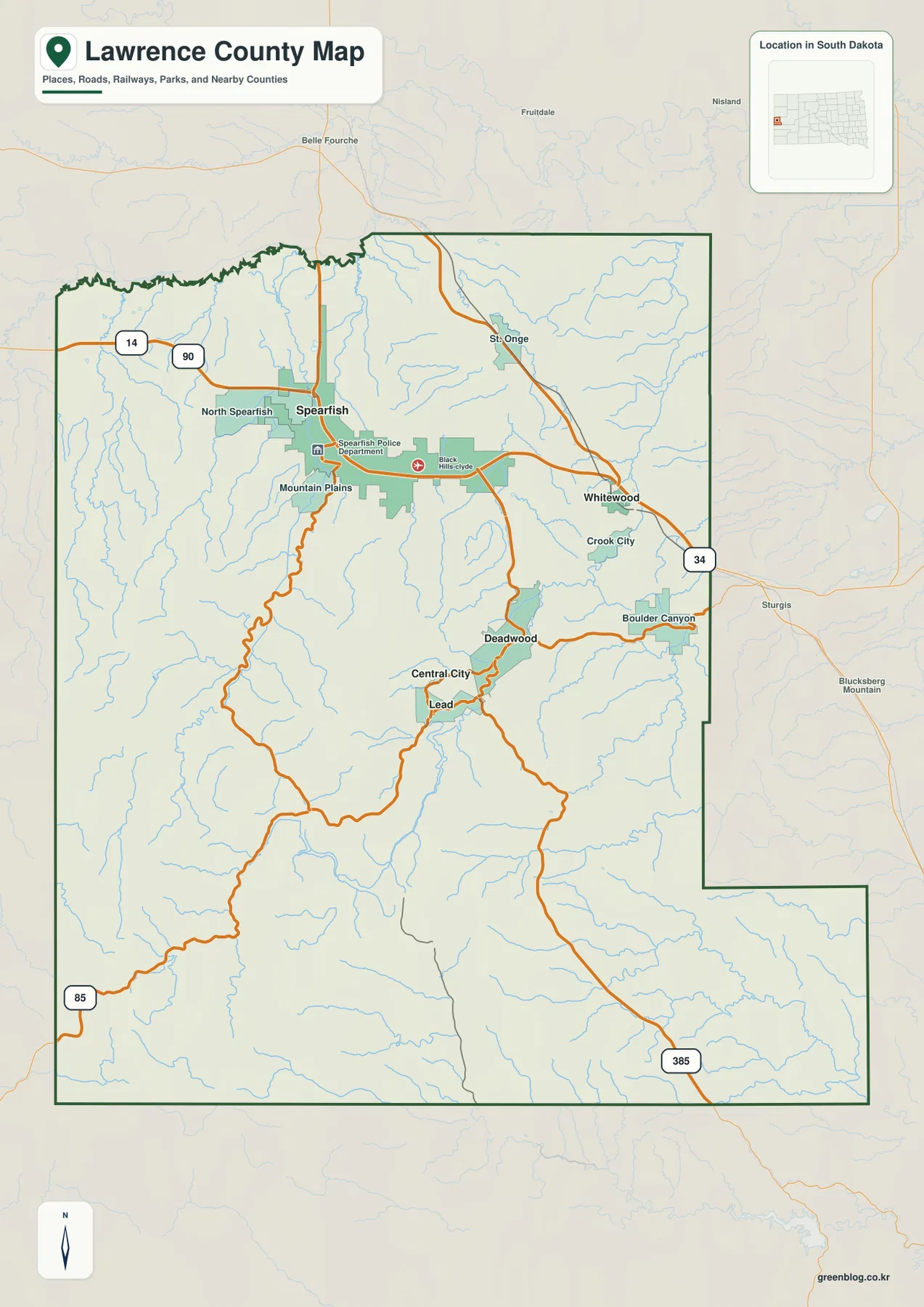
The city-distribution map strips away most of the road detail and makes the settlement pattern easy to compare. Spearfish stands apart in the northwest, Lead, Deadwood, and Central City form a compact group farther south, and Whitewood sits near the eastern side. The numbered symbols correspond to the CITY INDEX rather than to mileage. No connector lines or distance labels are drawn, so the map should not be used to estimate the drive from Spearfish to Deadwood or from Deadwood to Whitewood.
Creek valleys cut deeply into the Black Hills between Spearfish and the southeastern extension
The terrain-and-water map explains much of the road pattern. Crow Creek, Bear Creek, and Bill Creek occupy the northwest, while Spearfish Creek runs prominently through the western-central part of the county. Numerous smaller tributaries enter from narrow side valleys, and Iron Creek Lake is labeled nearby. The shaded relief makes clear that these streams are not simply crossing a flat surface; they occupy deep cuts between ridges that become more pronounced as the map moves into the Black Hills interior.
Farther east, Whitewood Creek is one of the main named waterways, with Polo Creek nearby and Bear Butte Creek along the eastern side. Elk Creek crosses the central-southern part of the county, and the southeastern extension is organized around Middle Boxelder Creek, South Boxelder Creek, and Boxelder Creek. Reausaw Lake is also labeled near that transition. Instead of one dominant river, Lawrence County contains several creek systems divided by high ridges, which is why the water map is especially useful for separating the Spearfish, Deadwood–Lead, Whitewood, and southeastern areas.
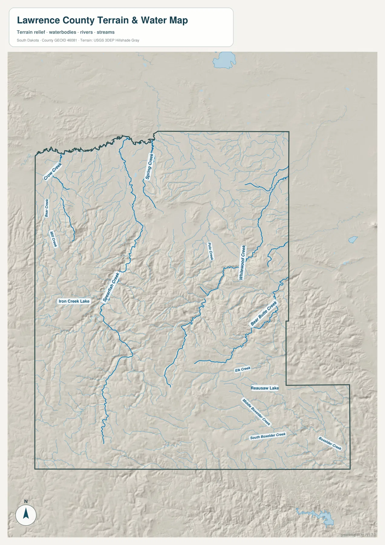
This map is a county-scale reference for named water features and terrain. Blue line width does not indicate current discharge, and the image is not a flood-hazard map, water-quality report, navigation chart, or legal shoreline product. For authoritative hydrography or a more detailed stream network, the USGS National Hydrography resources are the appropriate source.
A 911–2,172 m elevation range separates the northern low country from the high central and southwestern hills
The elevation map shows an actual county range of about 911 to 2,172 meters, with a mean near 1,531 meters. Much of the north and northeast is green, while yellow, orange, and brown spread across the central, southern, and southwestern Black Hills. The difference between the mapped low and high values exceeds 1,200 meters, which is unusually large compared with the flatter prairie counties farther east in South Dakota. That relief is the most direct explanation for the sharp visual difference between the Spearfish area and the Deadwood–Lead mountain country.
Spearfish lies within the lower northern zone, whereas Deadwood and Lead occupy higher, more dissected ground. The southwestern portion contains broad areas of the darkest high-elevation colors, broken by narrow valleys that appear lower than the surrounding ridges. The southeastern extension descends from the highest interior terrain but remains visibly more rugged than the northern lowlands. When the water map and elevation map are compared side by side, major creek corridors such as Spearfish Creek and Whitewood Creek line up naturally with lower valley floors between higher ridges.
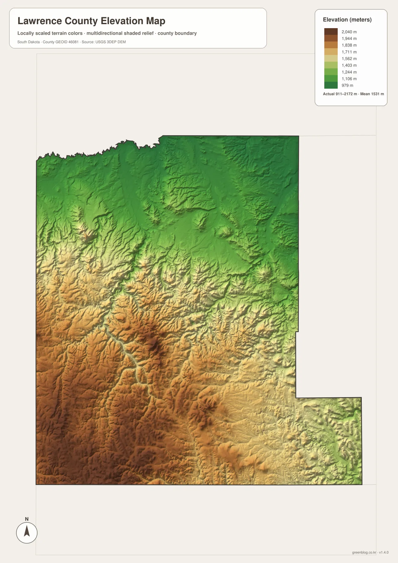
The elevation colors are intended for countywide comparison, not for survey or engineering measurements. Do not use the legend to assign an exact elevation to a parcel, building, road, or project site. Precise values should come from an authoritative elevation dataset such as the USGS 3D Elevation Program or from a survey suited to the specific task.
Use Spearfish, Deadwood, and Whitewood as anchors when moving between the maps
A simple way to connect the maps is to start with Spearfish and then move south to Deadwood and Lead. On the general map, note I-90 and US 14 around Spearfish; on the city map, find the Lead–Deadwood–Central City cluster; and on the water map, compare Spearfish Creek with Whitewood Creek. The elevation map then shows the same transition in another form, changing from the lower northern colors to the much higher central and southwestern hills. Whitewood works well as a third anchor for the eastern side and the SD 34 corridor.
If your main need is town and highway location, the general county map is the quickest reference. The city map is cleaner for relative settlement position, the terrain-and-water map is better for creek valleys and named water features, and the elevation map makes the large height difference unmistakable. Lawrence County becomes easier to understand when the same few places are followed across all four images instead of trying to memorize every label at once.
The WebP images in the article are optimized for browser viewing. The ZIP below contains the matching original JPG files at 2572 × 3638 pixels each, which are more suitable for close inspection, classroom use, presentations, or A3 printing. Printer margins and scaling vary, so check the print preview before producing a final full-size copy.
Frequently Asked Questions
Why are the roads around Deadwood and Lead more winding than the roads around Spearfish?
Spearfish sits in lower and more open northern terrain, while Deadwood and Lead are surrounded by higher Black Hills ridges and narrow creek valleys. The water and elevation maps show that the southern interior is more deeply cut, so roads have to follow valleys and passes rather than broad straight corridors.
Does the city map provide mileage from Spearfish to Deadwood?
No. The city map labels Spearfish, Lead, Deadwood, Whitewood, and Central City and uses numbered markers tied to the CITY INDEX, but it does not draw distance lines or mileage values. Use current routing information for driving distance and travel time.
Can the 911–2,172 m elevation range be treated as an exact elevation for a property?
No. The range summarizes elevation across the county and is useful for understanding overall relief. An exact parcel, road, or building elevation should come from authoritative elevation data or a survey appropriate to the intended use.
Map File Information
The ZIP contains the original JPG versions of the Lawrence County road-and-place map, city distribution map, terrain-and-water map, and elevation map.
- Printable Size: 2572 × 3638 pixels each
- File Type: ZIP containing 4 JPG files
Related Maps
Sources and references
- Lawrence County, SD – History – Official county background, borders, communities, and the Deadwood county seat.
- U.S. Forest Service – Black Hills National Forest – Official background on the Black Hills landscape that includes much of Lawrence County.
- U.S. Census Bureau TIGER/Line Shapefiles – Authoritative county, road, and place boundary data.
- USGS National Hydrography – Authoritative U.S. stream and water-feature data.
- USGS 3D Elevation Program – Authoritative elevation and terrain source data.
Green Map creates custom-edited map images using open geographic data sources such as geoBoundaries, Natural Earth, OpenStreetMap, and government open data.
These maps are edited visual materials, not raw data files, and are provided for education, documents, presentations, and graphic reference.