Lamar County occupies a compact part of west-central Georgia, with Barnesville functioning as both the county seat and the strongest visual landmark on the maps. From that central point, roads spread toward Milner, Aldora, neighboring counties, and the larger I-75 corridor, while a dense network of creeks and small water bodies cuts through the surrounding rolling ground. The four maps on this page separate those subjects so the county is easier to understand: one emphasizes boundaries and roads, one simplifies the relationship among the main labeled places, one brings waterways forward, and one shows the relief beneath them. A ZIP with four high-resolution A3 JPG originals is available in the map file box below.
The most useful feature of the set is that every map covers the same county but answers a different practical question. The county map is the quickest way to locate Barnesville and the main highway pattern. The city map shows how close Aldora is to Barnesville and how Milner sits farther northwest. The water map makes Barnesville Reservoir, the Little Towaliga River, Buck Creek, Big Towaliga Creek, and smaller ponds much easier to trace. The elevation map then explains why the landscape is described as rolling: higher ridges and lower stream valleys repeat across short distances rather than forming one broad, flat surface.
These are general-reference maps, not substitutes for navigation, legal boundary records, flood maps, or engineering surveys. That limitation is especially important when the water and elevation layers are used. A mapped creek does not define flood risk or public access, and a county-scale elevation surface is not precise enough for construction or parcel work. Used for orientation, study, printing, and local geographic reference, however, the four files provide a clear picture of how Barnesville, the road network, the drainage system, and the terrain fit together.
Table of Contents
Barnesville Gives the County Map Its Main Reference Point
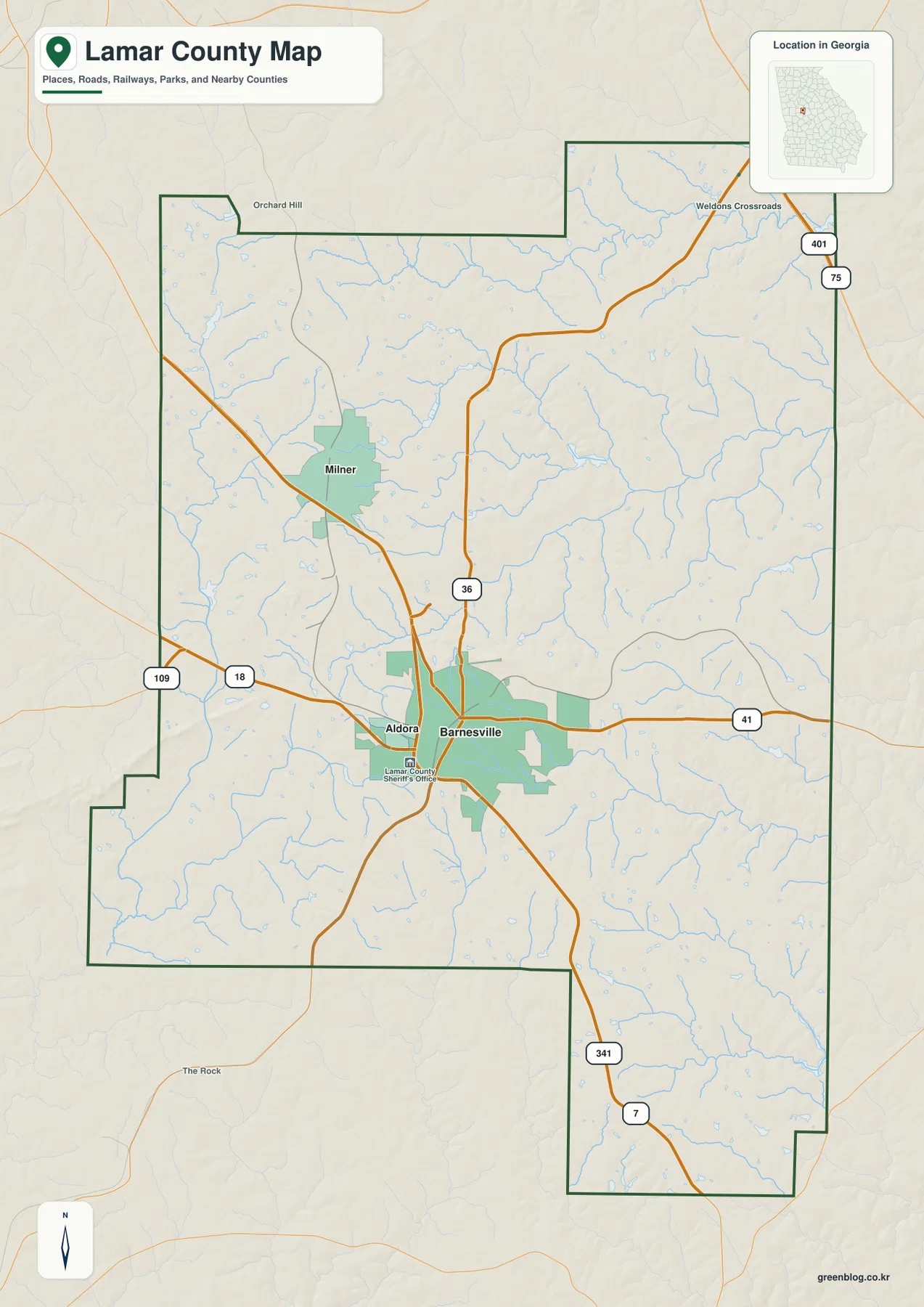
Barnesville occupies the middle of the county map and is surrounded by the largest continuous urban area shown in the preview. Aldora is immediately to the west, so close that the two developed areas nearly touch on the map, while Milner appears as a separate smaller place to the northwest. Labels outside the county line identify nearby Spalding, Pike, Upson, Monroe, and Butts counties. Those outside labels matter because Lamar County is not large enough to have a broad interior isolated from its neighbors; from Barnesville, the county line is never very far away in several directions.
The main roads also converge on Barnesville. The Georgia Department of Transportation county map identifies U.S. 41 and Georgia 7 in the Barnesville area, with U.S. 341 continuing south and Georgia routes 18 and 36 crossing other parts of the county. Route 36 turns toward the northeastern side, where the county approaches the I-75 corridor. On a regional scale, that gives Lamar County access to the major north-south route between the Atlanta and Macon areas while Barnesville remains the local junction for movement within the county.
This map is best used to understand the structure of the county rather than to plan a turn-by-turn drive. It shows the outline, principal roads, selected communities, streams, and the broader Georgia location without trying to label every local street. A reader who is new to Lamar County can begin here, identify Barnesville, note the direction of Milner and Aldora, and then use the other maps to investigate water or terrain at the same locations. That approach is more useful than treating each map as an unrelated illustration.
Lamar County’s official comprehensive-plan record describes the county as formed in 1921 from the eastern portion of Pike County and the western portion of Monroe County, with Barnesville as the county seat. The New Georgia Encyclopedia also describes the county as a rolling area drained by streams that ultimately reach the Flint and Ocmulgee river systems. That background fits what the supplied maps show: a strong central settlement and road focus around Barnesville, surrounded by an irregular network of creeks, ridges, and valleys rather than a single flat plain.
Aldora Sits Beside Barnesville While Milner Stands Apart to the Northwest
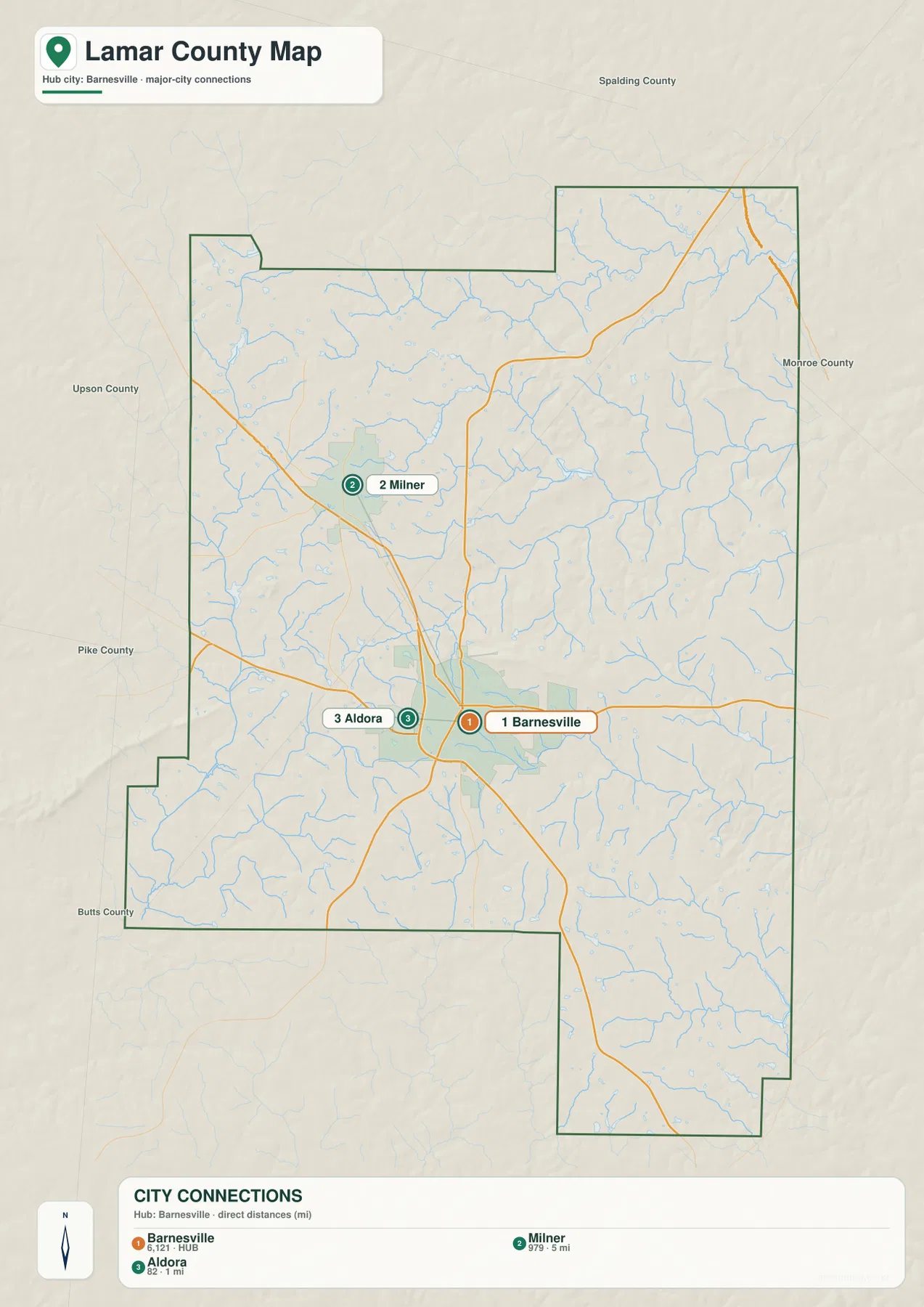
The city-connections map strips away much of the road-map detail and concentrates on three labeled places. Barnesville is marker 1 and the hub, Milner is marker 2 to the northwest, and Aldora is marker 3 immediately west of Barnesville. This simple arrangement makes a point that is easy to miss on a busier reference map: Lamar County has one dominant central urban footprint, one very nearby incorporated place on its western edge, and another separate city farther to the northwest.
The distances printed in the connection panel are straight-line measurements from Barnesville, not road mileage. Milner is shown at about 5 miles and Aldora at about 1 mile from the hub. They are therefore useful for comparing proximity, but they should not be copied into a driving itinerary as if they were route distances. A vehicle must follow the actual street and highway network, so the distance traveled can be longer, especially when the destination is not located at the map marker itself.
For a school project, local-history handout, or presentation, this map is often the clearest choice when the main question is where the named communities lie in relation to Barnesville. It does not attempt to show every unincorporated community, neighborhood, or street. Instead, it provides a clean visual hierarchy that can be paired with the county map whenever road numbers, surrounding county names, or a wider geographic context are needed.
The map also explains why Barnesville is a practical reference point for the rest of the page. Its urban area and road junctions dominate the central part of the county, while Aldora visually blends into the western side of that developed area. Milner, by contrast, sits far enough away to read as a separate community. Keeping that settlement pattern in mind makes the water and terrain maps easier to interpret because the reader always has a familiar central location for comparison.
Barnesville Reservoir Connects a Network of Creeks to the Little Towaliga
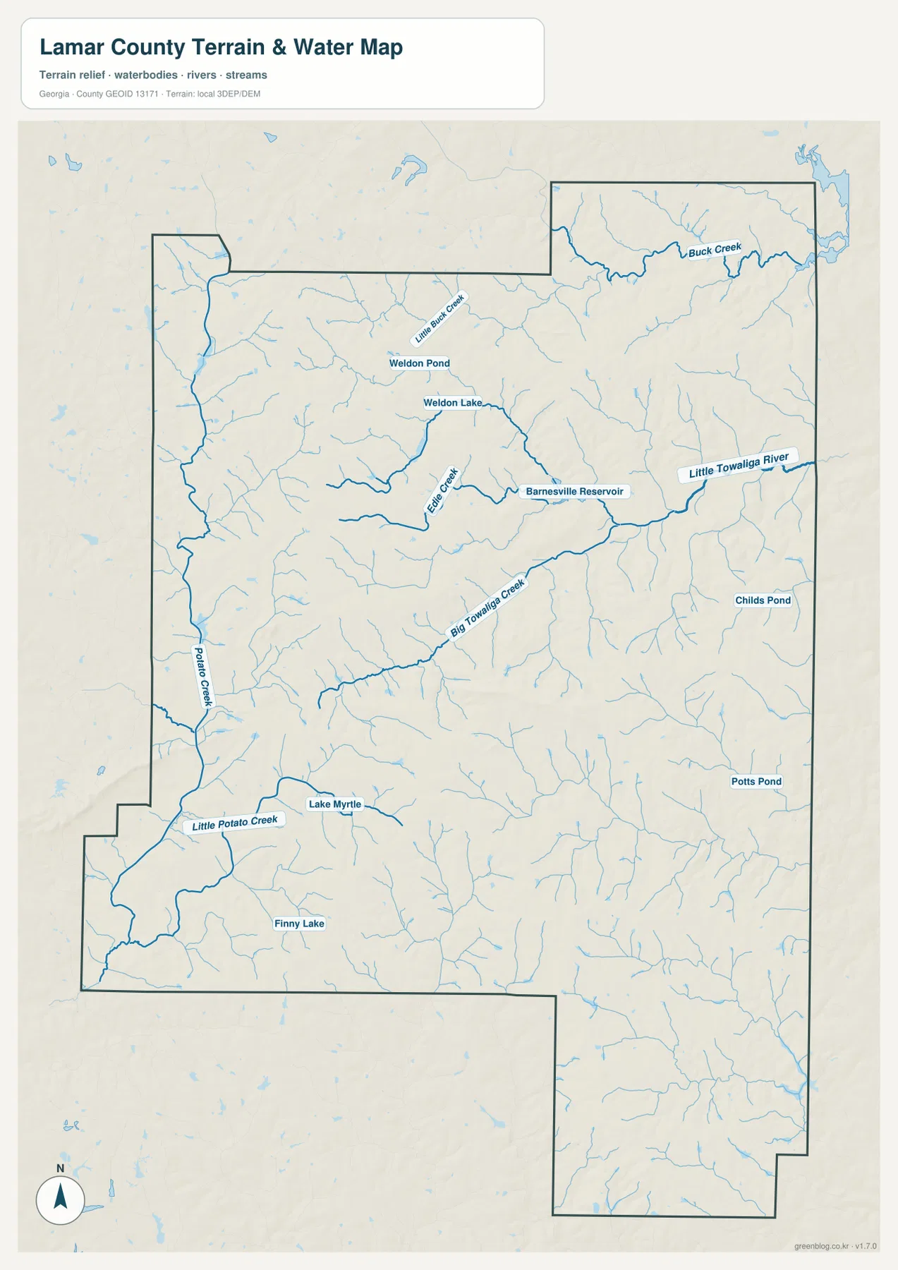
Water is distributed across Lamar County in many small channels rather than being concentrated in one dominant river. In the north, Buck Creek crosses the northeastern part of the county, while Little Buck Creek, Weldon Pond, and Weldon Lake appear farther west and south. Edie Creek approaches Barnesville Reservoir from the west, and the reservoir connects eastward into the Little Towaliga River. A U.S. Geological Survey study referenced by the existing article also identifies Edie Creek and related tributaries as headwater sources feeding Barnesville Reservoir before the water continues into the Little Towaliga system.
The central and southwestern parts of the map have their own named features. Big Towaliga Creek runs through the middle of the county, Potato Creek and Little Potato Creek appear along the western side, and Lake Myrtle and Finny Lake provide recognizable waterbody references in the southwest. Childs Pond and Potts Pond are labeled on the eastern side. Taken together, these names show that the county is divided by many small drainage lines and ponds, a pattern that is easy to overlook when roads and place names receive most of the visual attention.
The water map becomes more informative when it is compared with the county map. Barnesville remains the central human landmark, but the reservoir and river system just to its east and northeast show that the developed area sits close to an active network of small valleys and channels. Farther west, Potato Creek and its tributaries define a different set of low corridors. The result is not a county organized around one riverbank; it is a rolling landscape where many small streams move through separate valleys before joining larger systems beyond the map area.
A blue line on this map only indicates the mapped location of a water feature. It does not show a flood zone, expected water level, legal water boundary, navigable channel, fishing right, or public access point. Those questions require current information from the relevant agency or property authority. The value of this map is geographic: it helps the reader locate Barnesville Reservoir, the Little Towaliga River, Buck Creek, Big Towaliga Creek, and the smaller ponds and creeks in relation to the county boundary.
Elevation Changes Repeatedly Between Ridges and Stream Valleys
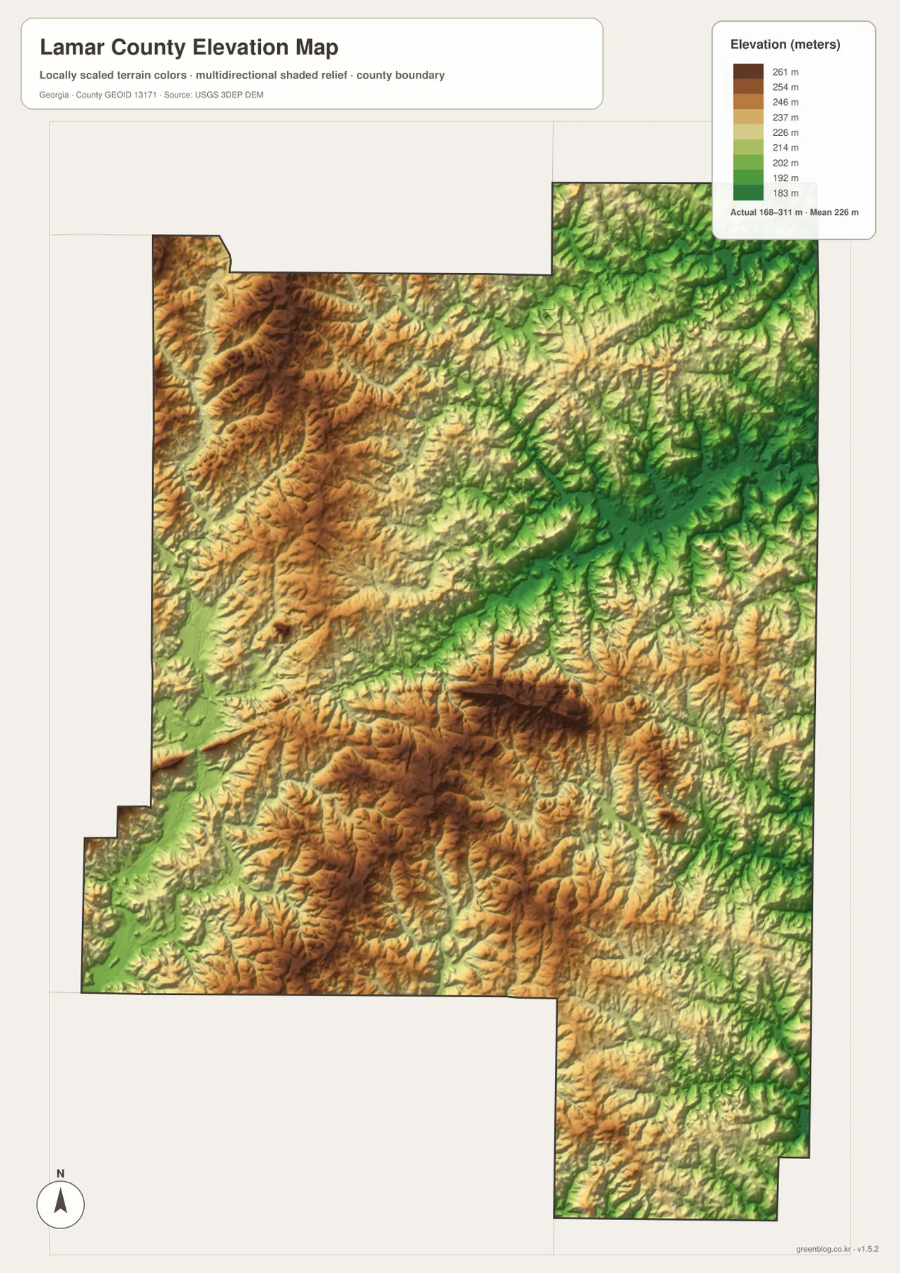
The elevation map reveals the physical surface that is hidden beneath the road and city symbols. Its legend reports an actual county elevation range of roughly 168 to 311 meters, with a mean near 226 meters. Higher ground appears in orange and brown. Broad elevated areas are visible across the west and northwest, and another strong high zone occupies part of the central-southern county. Lower ground is shown in green, especially in several eastern and northeastern valleys and in narrower western corridors.
What stands out is not a single mountain or one low plain but the frequency of the changes. Ridges and valleys repeat over short distances, giving the county a textured surface that matches the long-standing description of Lamar County as rolling country. The shaded relief makes small tributary valleys visible as branching cuts into the higher ground. That effect is particularly strong in the east, where many narrow green corridors converge around the Little Towaliga drainage system.
Comparing the elevation and water maps makes the relationship clearer. The Little Towaliga River and several eastern tributaries occupy lower green terrain, while Potato Creek and smaller western streams also follow lower cuts between ridges. This does not mean every low area contains a named stream or that every road curve is caused by relief, but the broad pattern is consistent: water tends to occupy the lower corridors while ridges form the higher ground between them. That relationship helps explain why the water map contains so many branching channels in a county that looks relatively compact on the boundary map.
The terrain surface is based on USGS 3DEP digital elevation data and has been generalized, colored, and hillshaded for county-scale comparison. It is useful for distinguishing higher and lower parts of Lamar County, illustrating ridge-and-valley terrain, and adding context to a report or classroom project. It is not a survey surface. Exact building-site elevations, drainage design, road construction, parcel work, and other engineering decisions require more precise data or field measurements.
Use the Four Maps as a Coordinated Lamar County Reference
The easiest way to choose a file is to start with the question you are trying to answer. For general orientation, the county map combines the boundary, Barnesville, major roads, nearby counties, and selected place names in one view. The city map is more efficient when you only need to compare Barnesville with Milner and Aldora. The water map should be the first choice for finding Barnesville Reservoir, the Little Towaliga River, named creeks, and ponds. The elevation map is the most informative when higher ridges, lower valleys, or the connection between terrain and drainage is the subject.
The maps also work well in pairs. A road or community found on the county map can be carried over to the water map to see which creeks lie nearby. The city map can establish the position of Milner or Aldora before the elevation map is used to examine the surrounding relief. Barnesville is an especially useful anchor because it appears at the center of the settlement pattern and sits close to the reservoir and Little Towaliga drainage. Moving between maps in this way turns four separate images into one geographic reference set.
- County map: use it for the boundary, Barnesville, principal roads, Milner, Aldora, nearby counties, and general orientation in Georgia.
- City map: use it for a clean comparison of Barnesville, Milner, and Aldora and the straight-line distances shown from the hub.
- Water map: use it to locate Barnesville Reservoir, Little Towaliga River, Buck Creek, Big Towaliga Creek, ponds, and smaller drainage features.
- Elevation map: use it to compare high ridges with low stream valleys and to see how quickly relief changes across the county.
The on-page WebP images are intended for fast browsing. If the map will be printed, placed in a presentation, saved for offline reference, or used in a classroom document, the downloadable JPG originals are the better files to keep. All four JPGs cover the same Lamar County area, so a project can use one map by itself or combine several without having to reconcile different geographic extents.
Barnesville Has Been the County’s Organizing Center Since Lamar County Was Created
Barnesville is more than a convenient label placed near the center of the map. According to the New Georgia Encyclopedia, settlement at Barnesville began in 1826, and local residents pursued creation of a new county for years. The official Lamar County comprehensive-plan record describes the county as formed in 1921 and identifies Barnesville as the county seat. That history helps explain why the present maps repeatedly return to the same place: county government, the broadest urban footprint in the supplied maps, and several important road connections all meet there.
The city also developed a distinctive history as a buggy-manufacturing center in the late nineteenth and early twentieth centuries, a legacy reflected in the community’s Buggy Days tradition. Gordon State College is another long-standing institution in Barnesville. Those details do not turn this page into a city guide, but they provide useful context for the map: Barnesville has served for generations as an institutional and transportation focus, while Milner and Aldora remain smaller reference points within the county.
The physical maps add another layer to that story. Barnesville sits inside a landscape where creeks and ridges are never far away, so the county’s human center is embedded in rolling terrain rather than separated from it. The reservoir and Little Towaliga system lie close enough to Barnesville to become major landmarks on the water map, while the elevation surface shows that the surrounding countryside changes height repeatedly. Reading the settlement and natural features together gives a more complete picture of Lamar County than either group of features can provide on its own.
Frequently Asked Questions
Do the 5-mile Milner and 1-mile Aldora labels show driving distance from Barnesville?
No. The city-connections map uses straight-line distance from Barnesville. It places Milner at about 5 miles and Aldora at about 1 mile from the hub, which is useful for comparing how close the two places are. A real trip follows the road network and can be longer depending on the starting point, destination, and route used.
Can the Barnesville Reservoir and Little Towaliga map be used to identify flood-prone property?
No. The water map shows the mapped locations of the reservoir, river, creeks, ponds, and other water features, but it does not contain flood zones, predicted water levels, or property-specific risk. Flood decisions require current FEMA or local-agency information. Use this map to understand where the water features lie within Lamar County, not to determine whether a parcel is safe from flooding.
What does the 168–311 meter elevation range tell me, and is it survey-grade?
The range describes the county-scale elevations represented on the map, with the legend also showing a mean near 226 meters. It is useful for comparing higher ridges and lower valleys across Lamar County. The surface is based on USGS 3DEP data but is generalized for clear visual reference, so construction, drainage design, parcel work, and exact site elevations should rely on more precise official data or field surveying.
Map File Information
The WebP images on this page are lightweight previews. The ZIP contains four high-resolution A3 JPG originals covering the same Lamar County area, making the archive the better option for printing, classroom materials, presentations, and offline reference.
- File Type: four high-resolution A3 JPG files in one ZIP
Related Maps
Sources and References
Lamar County formation and Barnesville’s county-seat role were checked against the Georgia Department of Community Affairs: Lamar County Comprehensive Plan. Barnesville background and the description of the local rolling landscape were also checked against the New Georgia Encyclopedia: Lamar County. Principal highway placement can be compared with the Georgia Department of Transportation Lamar County map. For the official nature of county boundary data, the U.S. Census Bureau TIGER/Line Shapefiles provide a standard federal reference.
Water-feature data can be checked through USGS National Hydrography, while the terrain layer is based on the type of elevation data provided by the USGS 3D Elevation Program. The maps on this page are designed as reader-friendly geographic references. For legal boundaries, flood determinations, engineering elevations, or other regulated decisions, use the latest authoritative source data from the responsible agency.
Green Map creates custom-edited map images using open geographic data sources such as geoBoundaries, Natural Earth, OpenStreetMap, and government open data. These maps are edited visual materials, not raw data files, and are provided for education, documents, presentations, and graphic reference.