Jackson County lies in southwestern Minnesota, where Interstate 90 and U.S. 71 meet near the city of Jackson, Heron Lake spreads across the northwest, and the Des Moines River cuts a lower valley down the eastern side. Lakefield occupies the county interior, while smaller communities such as Okabena, Alpha, and Wilder are scattered across a broad rural landscape.
This page uses the supplied county, city, water, and elevation maps to explain those local relationships with the actual places shown in the package. Original high-resolution JPG versions of all four views are also available in one ZIP download for printing, classroom work, presentations, or image editing.
Table of Contents
Jackson at the intersection of I-90 and U.S. 71
The city of Jackson is the easiest reference point on the general map. Interstate 90 crosses the county from west to east a little south of the midpoint, while U.S. 71 runs north and south through Jackson toward Iowa. The city’s mapped footprint sits close to the junction of those major routes, which makes it a practical starting point for orienting the rest of Jackson County.
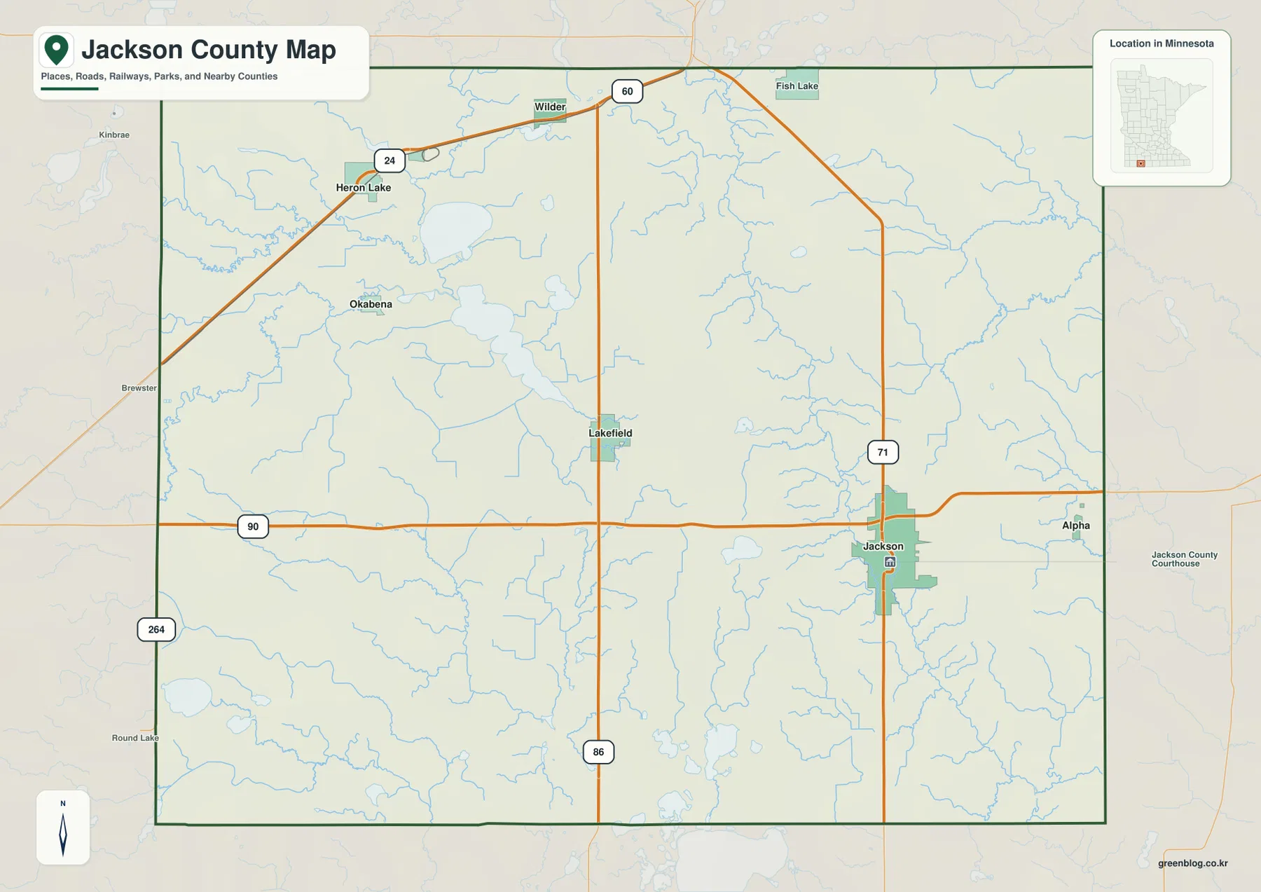
West of Jackson, I-90 continues across the county toward Nobles County. U.S. 71 heads north through the east-central interior, while Highway 86 runs through Lakefield farther west. Highway 60 crosses the northern part of the county on a diagonal, and Highway 24 is visible around the Heron Lake area. Those routes provide several distinct ways to understand the county instead of relying on one central road.
Highway 264 appears near the southwestern boundary, Alpha sits close to the eastern edge near the I-90 corridor, and Wilder lies near Highway 60 in the north. Okabena occupies the northwestern interior between Heron Lake and Lakefield. The road network looks simple in places, but local driving distances can still differ from straight map separation because of intersections, waterways, and rural road geometry.
Six major communities spread across the county
The city map highlights Jackson, Lakefield, Heron Lake, Okabena, Alpha, and Wilder. Jackson is in the southeast, Lakefield is near the center, and Heron Lake and Okabena occupy the northwest. Alpha sits near the eastern boundary, while Wilder is much farther north. The distribution makes it clear that the county’s communities do not form one compact cluster.
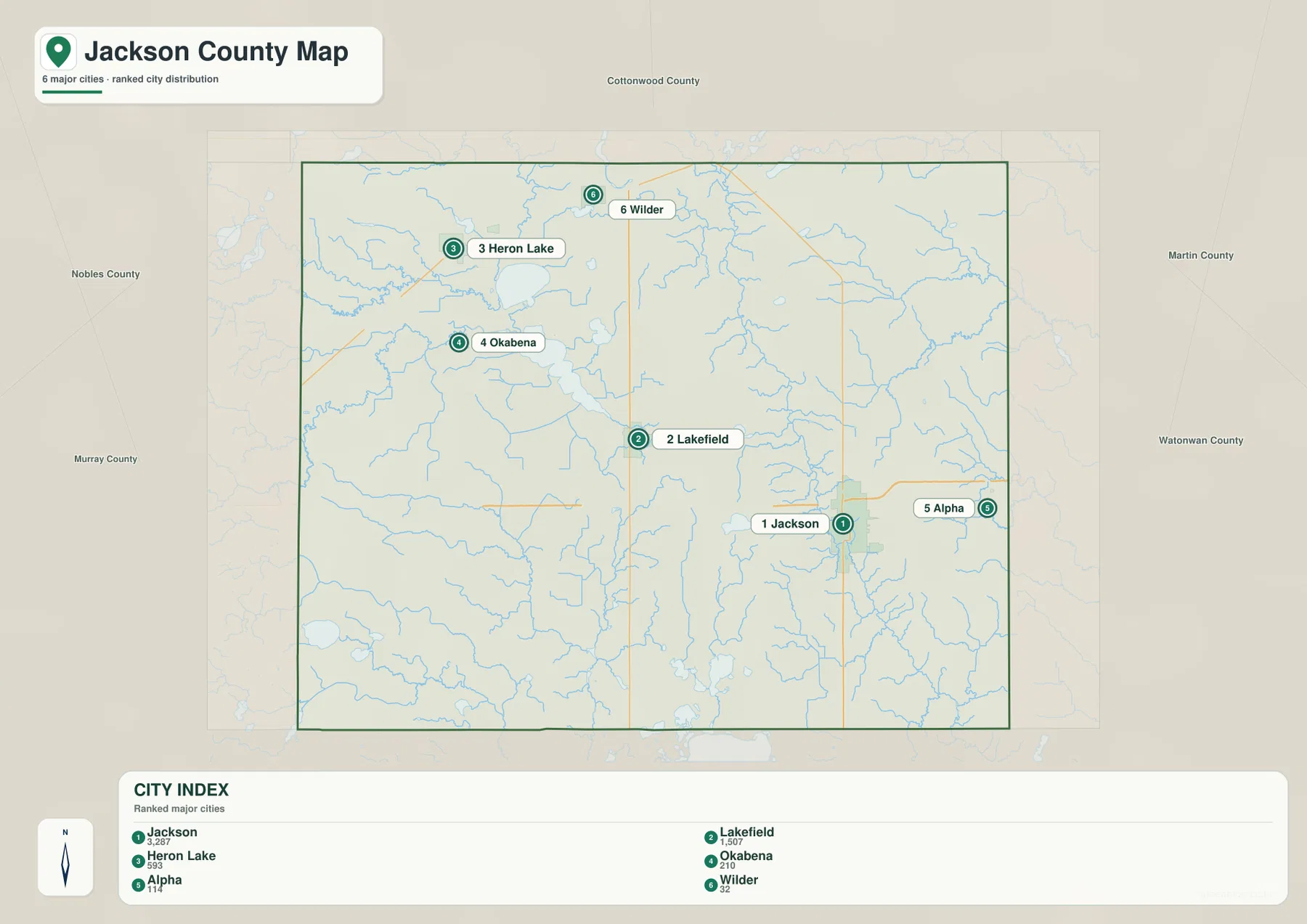
The CITY INDEX printed on the map lists Jackson at 3,287, Lakefield at 1,507, Heron Lake at 593, Okabena at 210, Alpha at 114, and Wilder at 32. These values should be treated as index figures embedded in the supplied map rather than as claims about the latest official population estimates. Their main value is comparative: Jackson is shown as the largest selected community, with Lakefield second and the remaining places much smaller.
Location adds another useful layer. Jackson is tied to the I-90 and U.S. 71 area, Lakefield sits along Highway 86, and Heron Lake and Okabena lie close to the county’s best-known lake system. Alpha provides an eastern reference, and Wilder anchors the north. Looking at those positions before returning to the road map makes the county much easier to navigate visually.
The city view is not a driving-distance chart. Travel between Jackson, Lakefield, Heron Lake, or the smaller communities depends on the road chosen and the exact starting point. Use this simplified map to understand direction and relative position, then use the general county map or current navigation data when mileage and travel time matter.
Heron Lake and the lake-and-creek landscape of the northwest
The northwest stands out immediately on the water map. Heron Lake and S Heron Lake occupy a broad low area, with Jack Creek and Okabena Creek feeding through the same region. Lake Flaherty is also labeled nearby. Together, these features show that the northwestern quarter is not simply open agricultural ground but a substantial lake-and-wetland landscape.
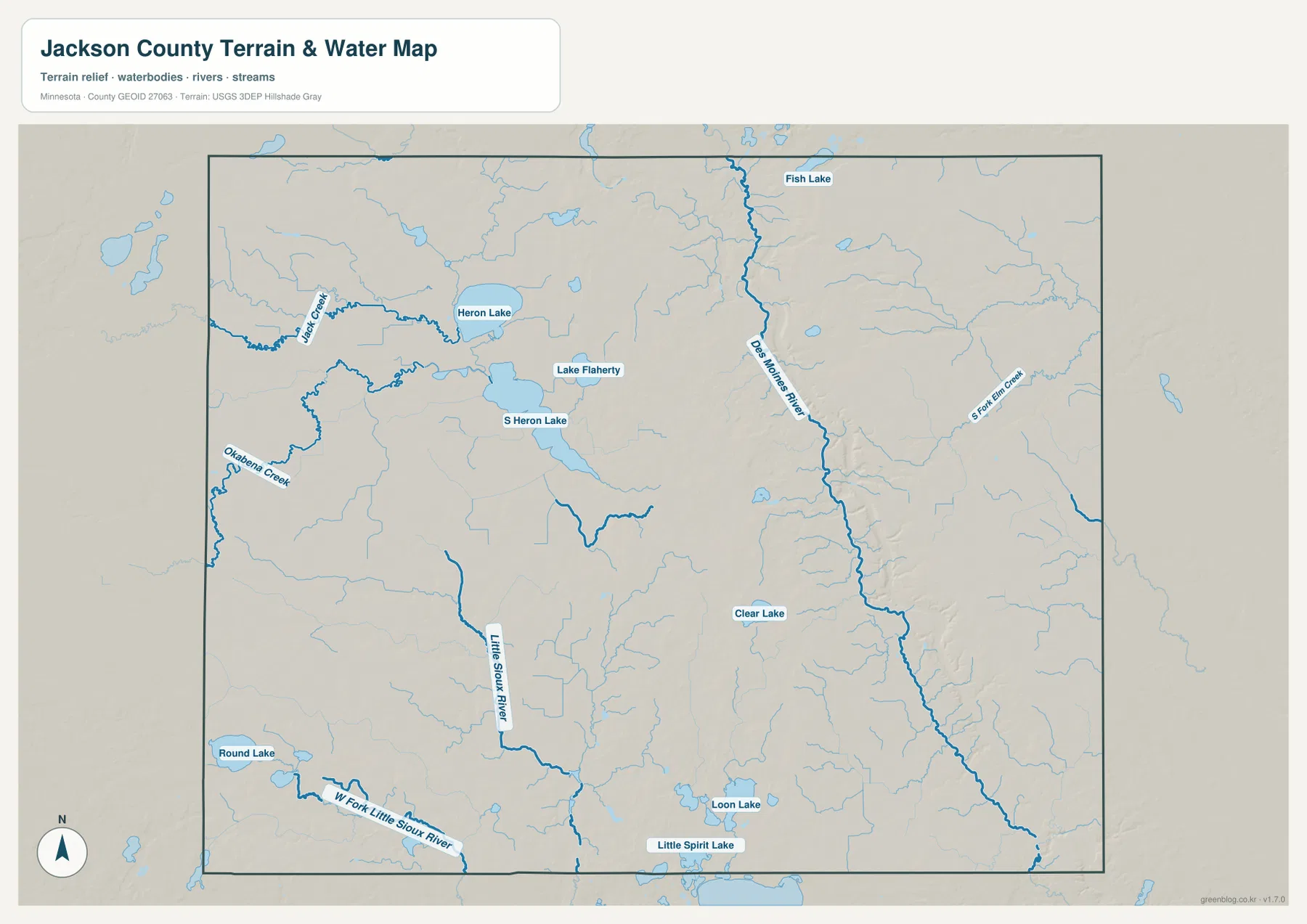
Jackson County’s official water-management material describes the Heron Lake system as evidence of a much larger ancient glacial lake that once covered part of the northwest. That context fits the supplied map, where Heron Lake and S Heron Lake occupy a broad, relatively low area with several creeks entering from surrounding farmland.
Other lakes are scattered well beyond Heron Lake. Fish Lake appears near the northern boundary, Clear Lake lies in the south-central interior, and Loon Lake and Little Spirit Lake sit close to the southern edge. Round Lake appears near the southwest. Those labels show that Jackson County’s water geography is distributed across the county rather than confined to one famous lake system.
The Des Moines River valley and the Little Sioux drainage
The Des Moines River is the strongest river reference on the eastern side. It enters from the north, follows a long southward course through east-central Jackson County, and continues toward the Iowa line. The river is drawn as a prominent channel on the water map, and its low valley is equally visible on the elevation view.
Jackson County’s water-management plan refers to this channel as the West Fork Des Moines River and notes that it runs along the east side of the Altamont moraine. The plan also describes the river valley as distinctly lower than the surrounding land. That county-specific description matches the elevation map, where a dark green low corridor follows the river southward.
The southwest drains differently. Little Sioux River and W Fork Little Sioux River occupy lower channels among higher terrain, while E Fork Elm Creek is labeled on the eastern side. These separate waterways make it clear that not every stream in Jackson County belongs to the same drainage system. The county sits across several watershed areas, which is one reason river directions differ from one side to another.
This water map is intended for geographic orientation, not for flood-hazard, navigation, parcel, or fishing decisions. It does not provide water depth, legal shoreline access, current stream conditions, or regulatory boundaries. Current county, state, and federal sources should be used when those details matter.
A 387–480 meter range between central uplands and the river valley
The supplied elevation map reports an actual range of about 387 to 480 meters, with a mean near 436 meters. The strongest brown high ground forms a broad north-south area through the central part of the county, with another elevated area in the southwest. By contrast, the Des Moines River side of the east is a long dark-green low corridor.
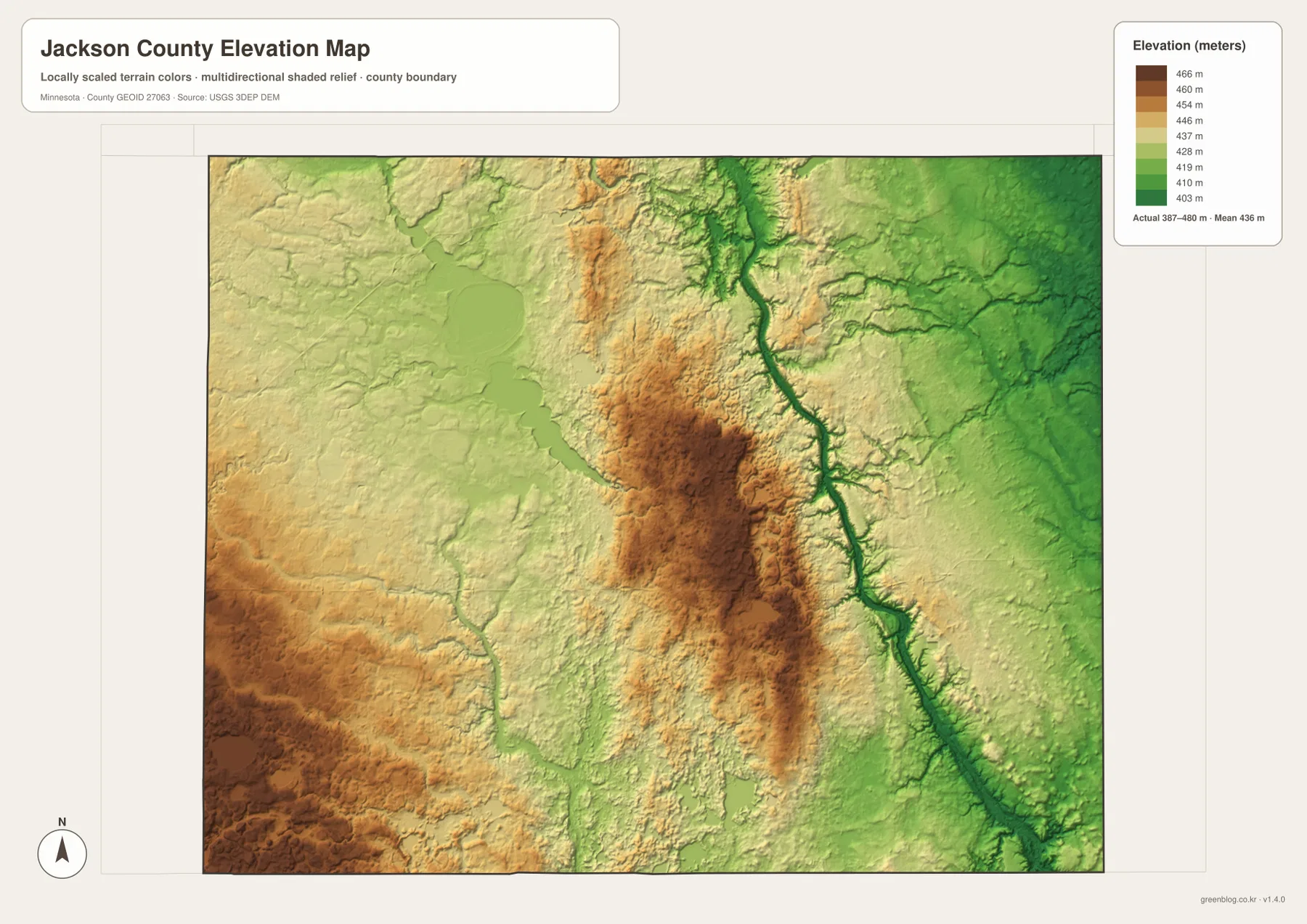
The central high area extends south from the Lakefield side as a broad, rolling upland. Moving east from that terrain toward the Des Moines River produces one of the clearest elevation changes on the map. Jackson sits near the eastern side of this transition, close enough to the river valley that the lower terrain becomes an important part of the city’s geographic setting.
The Heron Lake area is lower and gentler than the main central upland. Broad lake basins and creek corridors create more green and light-toned terrain in the northwest. Farther southwest, higher browns return, which matches county water-planning material that describes the southwest as hillier and dotted with smaller water bodies.
The Des Moines River valley is the strongest low feature from north to south. Tributaries cut additional narrow channels into the surrounding surface, making the eastern side more varied than a flat agricultural map might suggest. Jackson County is still a prairie and farming county, but the elevation view shows meaningful differences between moraine uplands, lake basins, and river valleys.
This elevation surface is appropriate for county-scale comparison, not for surveying or engineering. It should not be used for exact building elevations, road grades, drainage design, or parcel-level contour decisions. Detailed USGS 3D Elevation Program products or professional survey information are the better sources when precision matters.
Jackson, Lakefield, and Heron Lake occupy different settings
Jackson is the county’s strongest road and administrative center, but it is not located on the highest ground. The city sits close to the Des Moines River valley, with I-90 and U.S. 71 adding transportation importance to an already distinct geographic location. The water and elevation views show why Jackson’s setting differs from the higher central interior just to the west.
Lakefield lies northwest of Jackson and closer to the central upland. Highway 86 gives it a clear north-south reference, while nearby small lakes and drainage channels break up the surrounding farmland. Compared with Jackson, the city is less tied to one major river valley and more closely associated with the gently rolling interior.
Heron Lake and Okabena occupy a third setting. Their landscape is organized around broad lake basins, Jack Creek, Okabena Creek, and relatively low northwestern terrain. Looking at those places together with Jackson and Lakefield is a simple way to understand why one county can contain a major river valley, a central upland, and a large lake system within a fairly compact area.
Choosing the right Jackson County view
Use the general county map when roads, boundaries, and community names need to appear together. The city map is cleaner when the goal is to compare Jackson, Lakefield, Heron Lake, Okabena, Alpha, and Wilder without every road and stream. Using the city view first and the general map second is an easy way to connect place names with I-90, U.S. 71, Highway 60, and Highway 86.
The water map is the stronger choice for Heron Lake, the Des Moines River, Little Sioux River, and the county’s smaller lakes and creeks. Pair it with the elevation map when you need to show why the eastern river valley is lower than the central uplands or why the northwestern lake basin looks different from the southwest hills.
For printing or image editing, the original JPG files in the ZIP provide more resolution than the WebP previews embedded in the article. Each JPG measures 3638 by 2572 pixels, and the archive contains the county, city, water, and elevation maps.
Official Jackson County and federal sources for detailed work
Jackson County’s official website identifies Jackson as the county’s administrative center and provides access to local government information. Its Property Information Search uses a public GIS portal for property and geographic records. Parcel boundaries, taxes, permits, legal descriptions, and other administrative decisions should rely on those current county services rather than on a general-purpose map.
The county’s Comprehensive Plan and water-management documents provide additional local context for transportation, Heron Lake, the Des Moines River, and the county’s physical setting. U.S. Census Bureau TIGER/Line files are appropriate for boundary and road data, USGS National Hydrography supports river and stream work, and the USGS 3D Elevation Program provides detailed elevation products.
Frequently Asked Questions
Which major roads meet near the city of Jackson?
Interstate 90 crosses Jackson County from west to east, while U.S. 71 runs north and south through the Jackson area. The two routes meet near the county’s largest mapped community and provide the clearest road reference for the southeastern part of the county.
Where does the Des Moines River run through Jackson County?
The supplied water map shows the Des Moines River running down the eastern side of the county. Jackson County’s official water-management material refers to this channel as the West Fork Des Moines River and describes its valley as lower than the surrounding landscape.
What elevation range is shown for Jackson County?
The supplied elevation map reports an actual range of about 387–480 meters with a mean near 436 meters. Higher terrain is most prominent through the central interior and southwest, while the Des Moines River corridor is lower. Exact site elevations require detailed USGS or survey data.
Map File Information
Download the original high-resolution JPG versions of the Jackson County maps shown on this page in one ZIP file.
- Included Files: county map, city map, water map, elevation map
- Printable Size: each JPG is 3638 × 2572 px
- File Type: ZIP containing 4 JPG files
Related Maps
Sources and references
- Jackson County, Minnesota official website – county government and local information
- Jackson County Property Information Search – public GIS property and geographic records
- Jackson County Comprehensive Plan – local transportation and planning reference
- U.S. Census Bureau TIGER/Line Shapefiles – boundary, road, and place data
- USGS National Hydrography – river, stream, and water data
- USGS 3D Elevation Program – elevation data and products
Green Map creates custom-edited map images using open geographic data sources such as geoBoundaries, Natural Earth, OpenStreetMap, and government open data. These maps are edited visual materials, not raw data files, and are provided for education, documents, presentations, and graphic reference.