Alexandria is the most useful starting point for reading Douglas County. The city occupies a broad area in the south-central part of the county, major roads converge around it, and a dense group of lakes begins almost immediately to the north. That combination makes the county easier to understand as a connected landscape rather than as a collection of separate town names. The maps on this page can be viewed online, and the download box near the end of the article provides the same map set as high-resolution A3 JPG files in a ZIP archive.
Water is the feature that repeatedly reshapes the county map. Lake Carlos and Lake Ida sit north of Alexandria, Lake Miltona lies farther to the northeast, and dozens of smaller lakes break up the western and southern interior. Rivers add another layer: the Long Prairie River occupies the eastern side while the Chippewa River appears on the west. Elevation shading shows that the land between those waters is rolling rather than uniformly flat, with short ridges, low pockets, and river corridors that help explain why roads and settlements take the routes they do.
Table of Contents
Alexandria provides the clearest reference point for roads and nearby lakes
On the general county map, Alexandria stands out as the largest built-up area. Minnesota routes 29 and 27 pass through or close to the city, while Route 94 approaches from the west and Route 52 extends toward the eastern side of the county. These roads make Alexandria a practical anchor for locating smaller communities. Evansville and Brandon can be placed to the west, Osakis lies close to the eastern boundary, and Carlos and Miltona sit to the north along the same broad north-south side of the county.
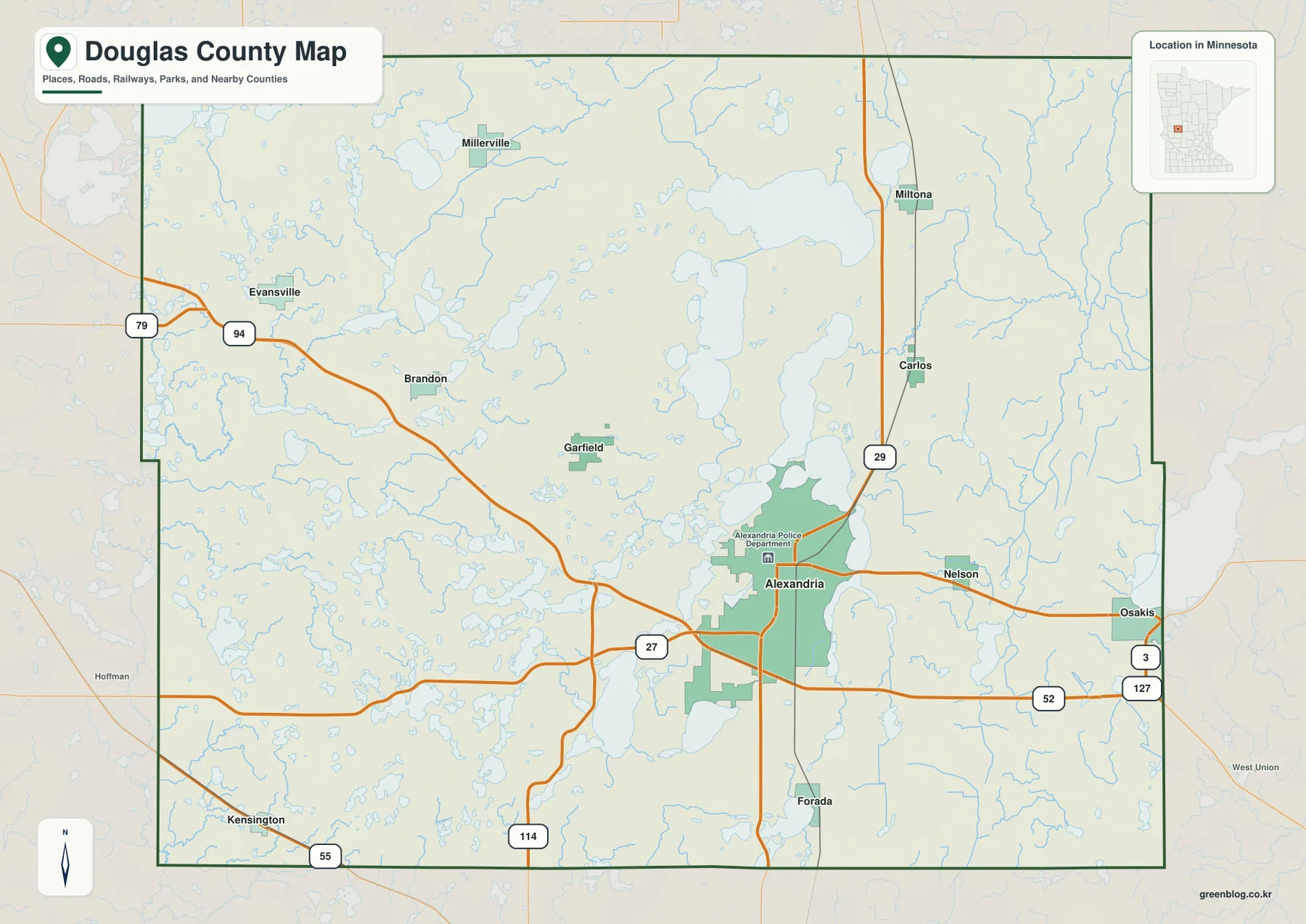
The map also shows why straight-line distance is not always a good guide to travel in this part of Minnesota. North of Alexandria, large lakes occupy broad stretches of ground, so roads frequently use the land between shorelines rather than cutting directly across the county. West of the city, smaller water bodies are more scattered, creating a different road pattern. The contrast is visible without needing a technical transportation map: the water itself helps explain where the main routes can and cannot go.
Smaller places such as Garfield, Nelson, Forada, and Kensington add useful local reference points that are not emphasized on the simplified city-ranking map. Those names matter when you are tracing a route, describing the location of a lake, or preparing a local geography lesson. The general map is therefore the better choice when a question involves both a place name and the roads or water around it, while the city map is cleaner when the main goal is simply to compare the larger settlements.
Alexandria dominates the city pattern while smaller communities remain widely dispersed
The ranked city map makes the size difference especially clear. Alexandria is labeled with a population of 14,735, far above Osakis at 1,623 and the smaller communities of Evansville, Carlos, Brandon, and Miltona, each shown in the hundreds. These values are best treated as map-reference figures rather than as a substitute for the latest official population estimates. Their value here is visual: they make it immediately obvious that the county has one dominant urban center and a set of much smaller towns spread across a large lake-filled area.
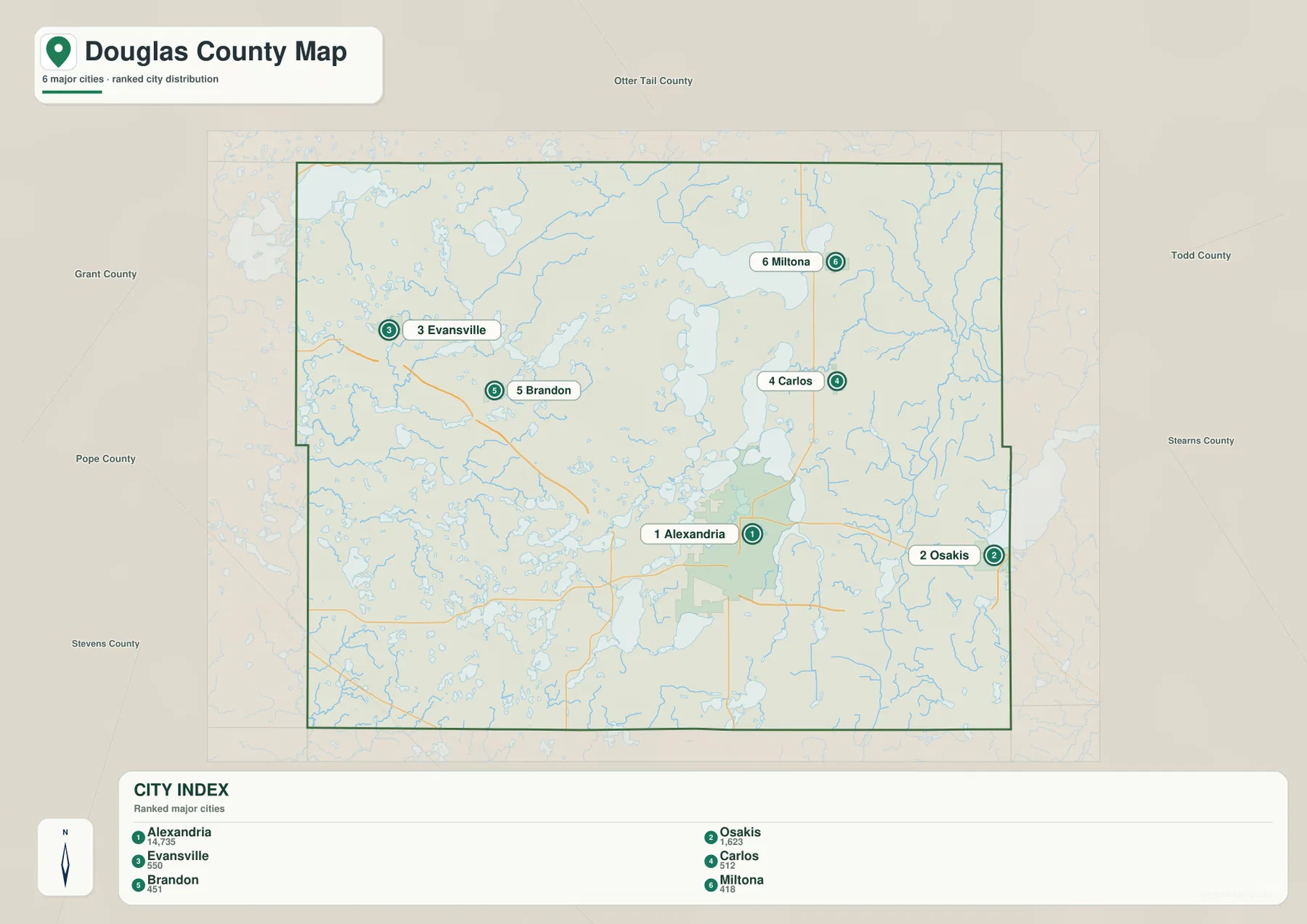
Osakis occupies a very different geographic position from Alexandria because it sits close to the eastern edge of the county. Evansville, by contrast, is near the western side, where connections toward Grant County become relevant. Carlos and Miltona are north of Alexandria and separated by lake country, so a line between the town symbols does not describe the actual travel environment very well. The city map is useful precisely because it strips away many of those details first, allowing the reader to establish the broad arrangement before returning to the more detailed views.
This distribution also hints at how services and daily travel are organized. A large center such as Alexandria is likely to appear repeatedly in countywide directions because it offers a recognizable point from which other locations can be described. The smaller towns remain important local anchors, especially for the northern and western parts of the county where lakes and open land create longer gaps between settlements. Reading the map in that way is more informative than treating the numbered city ranking as a simple list.
Lake Carlos, Lake Ida, and Lake Miltona form the most conspicuous northern lake group
The water map shows the county’s lake character more clearly than any other view. Lake Carlos lies immediately north of the Alexandria area, and Lake Ida occupies a larger position to its northwest. On the north side of Lake Ida, Christopherson Bay and Waterlily Bay are labeled separately, emphasizing that the shoreline is irregular rather than a simple oval. Farther northeast, Lake Miltona forms another large water body near the community of Miltona. Together, these lakes create a recognizable northern pattern that can be used to orient many nearby places.
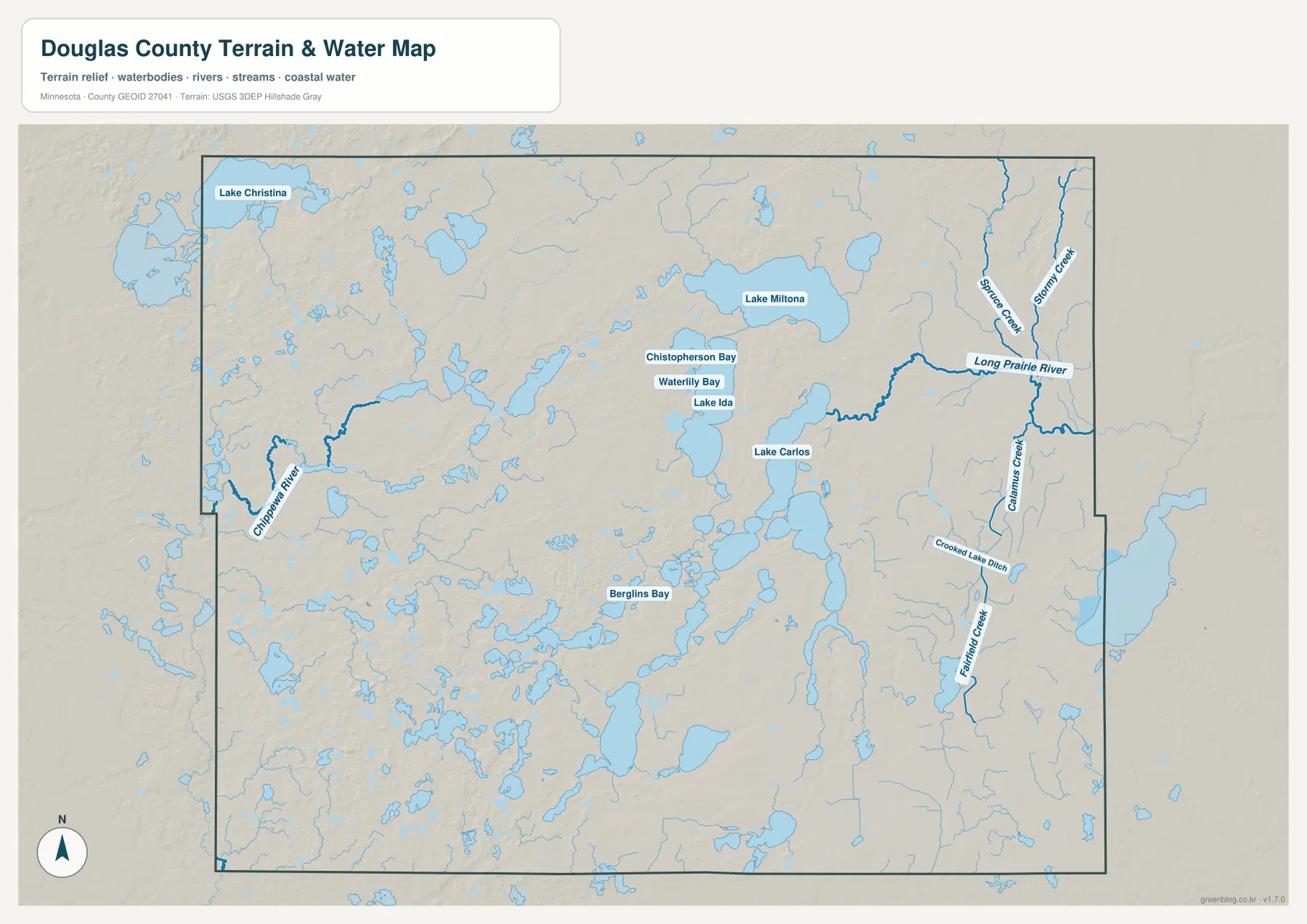
The named lakes are only the most visible part of the story. Smaller lakes and ponds occur throughout the western interior and southern half of the county, and long water bodies also appear around Alexandria itself. The result is a landscape in which roads frequently bend around shorelines and parcels of higher ground are separated by water or wet lowlands. That is one reason a simple city-to-city line can be misleading: a short distance on the page may still involve a route that curves around several lakes.
Water is also tied to recreation and public access. Douglas County’s official information highlights places such as Lake Brophy County Park, Lake Le Homme Dieu Beach, and Chippewa Park. The maps here are useful for understanding where those kinds of destinations fit within the broader county, but they do not provide boat-ramp details, fishing regulations, water depth, or seasonal operating information. For a visit, use the map to establish location first and then consult the responsible county or facility page for current conditions.
The Long Prairie River and Chippewa River occupy different sides of the county
The eastern half of the water map contains a network centered on the Long Prairie River. Spruce Creek and Stormy Creek enter the same general area from the northeast, while Calamus Creek, Crooked Lake Ditch, and Fairfield Creek appear farther south. These narrow waterways contrast with the broad lakes north of Alexandria. Instead of creating large open water surfaces, they trace elongated low corridors through the eastern landscape.
On the western side, the Chippewa River follows a separate course through a landscape filled with smaller lakes and low ground. The two river systems do not collapse into one obvious countywide drainage line on this map. That separation is useful because it shows why Douglas County cannot be described as a place where all water simply runs toward one edge. When the water map is compared with elevation shading, many river reaches correspond with lower terrain, while higher ridges stand between different groups of lakes and streams.
The map is appropriate for county-scale orientation, not for engineering or flood analysis. Small ditches, seasonal channels, and detailed shoreline changes may be simplified or omitted at this scale. Anyone working on drainage, flood exposure, a stream crossing, or another site-specific question should consult the latest official hydrography and local records. The USGS National Hydrography resources linked below are a more suitable starting point for that level of detail.
Relief from about 357 to 492 meters separates lake basins from short upland ridges
The elevation map gives Douglas County an appearance very different from a perfectly flat prairie. Its displayed range is approximately 357 to 492 meters, with a mean near 420 meters. Higher browns and tans occupy broad parts of the central and northern interior, while lower greens are more noticeable along parts of the western edge and in eastern river country. The repeated change from high to low over short distances reflects the rolling terrain that surrounds many of the county’s lakes.
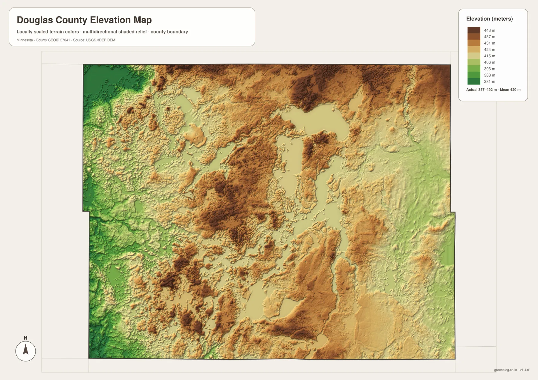
Around Lake Ida and Lake Carlos, the shaded relief reveals higher ground wrapping around parts of the basins. Similar short ridges and depressions appear among the many small lakes in the southwest. On the eastern side, some lower terrain follows the Long Prairie River system, making the connection between drainage and relief easier to see. The map does not imply that every shoreline has a steep slope, but it does make clear that the county’s lake landscape is built into uneven ground rather than a level surface.
The colors should be interpreted at the county scale. They are excellent for comparing broad high and low areas but are not precise enough to determine a building-site elevation, road grade, drainage design, or flood level. Parcel-level work requires more detailed elevation data and, where necessary, field surveying. The purpose of this map is to show the shape of the county’s terrain and to help explain the relationship between ridges, lakes, and river valleys.
Use the detailed views to answer different questions about the same place
A visitor planning a drive from Alexandria will usually get the most value from the general map because it combines towns, roads, and water in one frame. A student comparing settlement size may prefer the city map because the large difference between Alexandria and the smaller communities is immediately visible. Someone interested in lakes or stream connections should move to the water view, while the elevation map becomes useful when the question involves ridges, low corridors, or why a river follows a particular part of the county. The maps work best as complementary views rather than as a fixed sequence.
Consider a trip from Alexandria toward Lake Miltona. The general map establishes Route 29 and the position of Carlos, while the water map explains how Lake Carlos and the surrounding lakes shape the corridor farther north. A different question around Osakis would start with the eastern boundary and Routes 52, 3, and 127, then shift to the river view to understand the nearby Long Prairie River network. By keeping the geographic anchor constant and changing only the information layer, it becomes easier to avoid confusing one lake, road, or town with another.
For printing or presentation work, the downloadable A3 JPG files are preferable to the smaller WebP images used on the page. The JPGs are supplied at 3638 by 2572 pixels, which preserves labels and linework more clearly when the image is enlarged in a document or slide. They remain general-reference maps, however. Legal boundary determinations, navigation, land ownership questions, engineering, and professional surveying should rely on the appropriate authoritative source rather than on these presentation maps.
Frequently Asked Questions
Which map is most useful for comparing Alexandria and Osakis?
The city map is the quickest way to compare their relative position and scale. If you also need the travel context, use the general map to follow Route 52 east from the Alexandria area and to see Routes 3 and 127 near Osakis.
Where are the easiest large lakes to identify in Douglas County?
Lake Carlos and Lake Ida are prominent north of Alexandria, and Lake Miltona is farther northeast. Many smaller lakes are scattered across the west and south, so the large named lakes should be treated as orientation landmarks rather than the county’s only important water bodies.
Can the 357–492 meter elevation range be used for a property survey?
No. The range is intended to compare broad relief across the county. Parcel elevations, building grades, drainage design, and legal survey work require more detailed official elevation data and, when appropriate, professional field measurements.
Sources and reference material
- Douglas County official website – county government and local information
- Douglas County Water Attractions – lake and waterfront recreation information
- Douglas County Parks & Trails – county parks and outdoor facilities
- U.S. Census Bureau TIGER/Line Shapefiles – boundary and road reference data
- USGS National Hydrography – rivers, streams, and water features
- USGS 3D Elevation Program – elevation data and related products
Map File Information
Download the map files associated with this page for reference, printing, and compatible visual projects.
- Included Files: Use only the versions confirmed in the article and supplied images
- File Type: Use the confirmed download contents
- Intended Use: Printing, education, presentations, and map-based projects
Related Maps
Green Map creates custom-edited map images using open geographic data sources such as geoBoundaries, Natural Earth, OpenStreetMap, and government open data. These maps are edited visual materials, not raw data files, and are provided for education, documents, presentations, and graphic reference.