Faribault County lies along Minnesota’s southern border with Iowa, with Blue Earth serving as the main western-center reference point and Wells anchoring the eastern side of the county. The supplied maps show towns, numbered highways, the Blue Earth River and its branches, the Maple River and Cobb River, several named lakes, and a clear rise in elevation toward the southeast. After using the maps below to understand the county, you can download the four original high-resolution JPG files together in one ZIP archive.
A practical way to get oriented is to locate Blue Earth and Wells first. Blue Earth sits in the southwest-central part of the county where north-south and east-west routes meet, while Wells lies farther east at another road junction. Winnebago, Delavan, Easton, Minnesota Lake, Kiester, and Elmore spread outward from those two centers. The waterways and elevation map add an important second layer: western river valleys are generally lower, while the southeast contains the county’s most pronounced high ground.
Table of Contents
Blue Earth and Wells as the county’s main map anchors
The general county map makes Blue Earth and Wells the easiest places to use as orientation points. Blue Earth appears as the broadest built-up area in the southwest-central part of Faribault County. Highway 169 runs down from the Winnebago area toward Blue Earth and continues south, while Highway 90 crosses the county from west to east near the city. Wells is farther east, where Highway 22 runs north-south and Routes 21 and 109 connect with the surrounding road network.
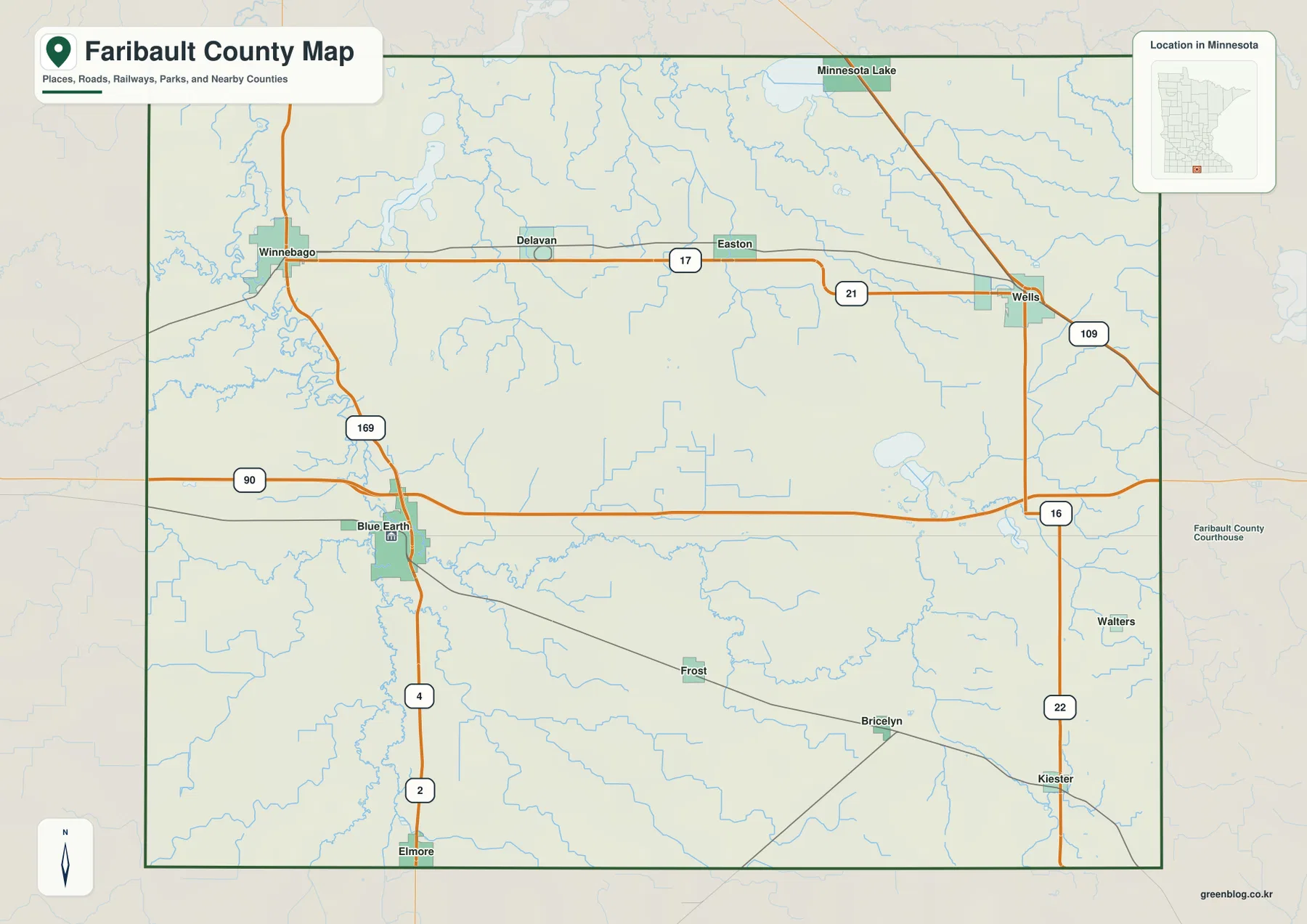
Across the northern part of the county, Winnebago, Delavan, and Easton line up near Route 17, with Route 21 dropping southeast from Easton toward Wells. Minnesota Lake sits close to the northern boundary. Farther south, Elmore is near Routes 2 and 4, while Kiester lies on the eastern side along Highway 22. This arrangement shows that Faribault County does not have a single continuous urban corridor; instead, small communities are distributed around several road connections.
Neighboring county labels help place Faribault County within southern Minnesota. Blue Earth County and Waseca County are shown to the north, Martin County lies to the west, and Freeborn County is to the east. The southern edge is the Minnesota-Iowa state line, making Elmore and Kiester much closer to the state boundary than the northern towns. The map is useful for geographic orientation, but current road closures, construction, and driving conditions should always be checked with up-to-date transportation information.
A six-city view from Blue Earth to Minnesota Lake
The city map removes much of the background detail and highlights six places: Blue Earth, Wells, Winnebago, Minnesota Lake, Kiester, and Elmore. Blue Earth occupies the southwest-central position, Wells stands in the east, and Winnebago lies toward the northwest. Minnesota Lake is near the northern edge, while Kiester and Elmore mark the southeast and southwest portions of the county. The simplified layout is useful when the main task is comparing settlement positions rather than reading every road or stream.
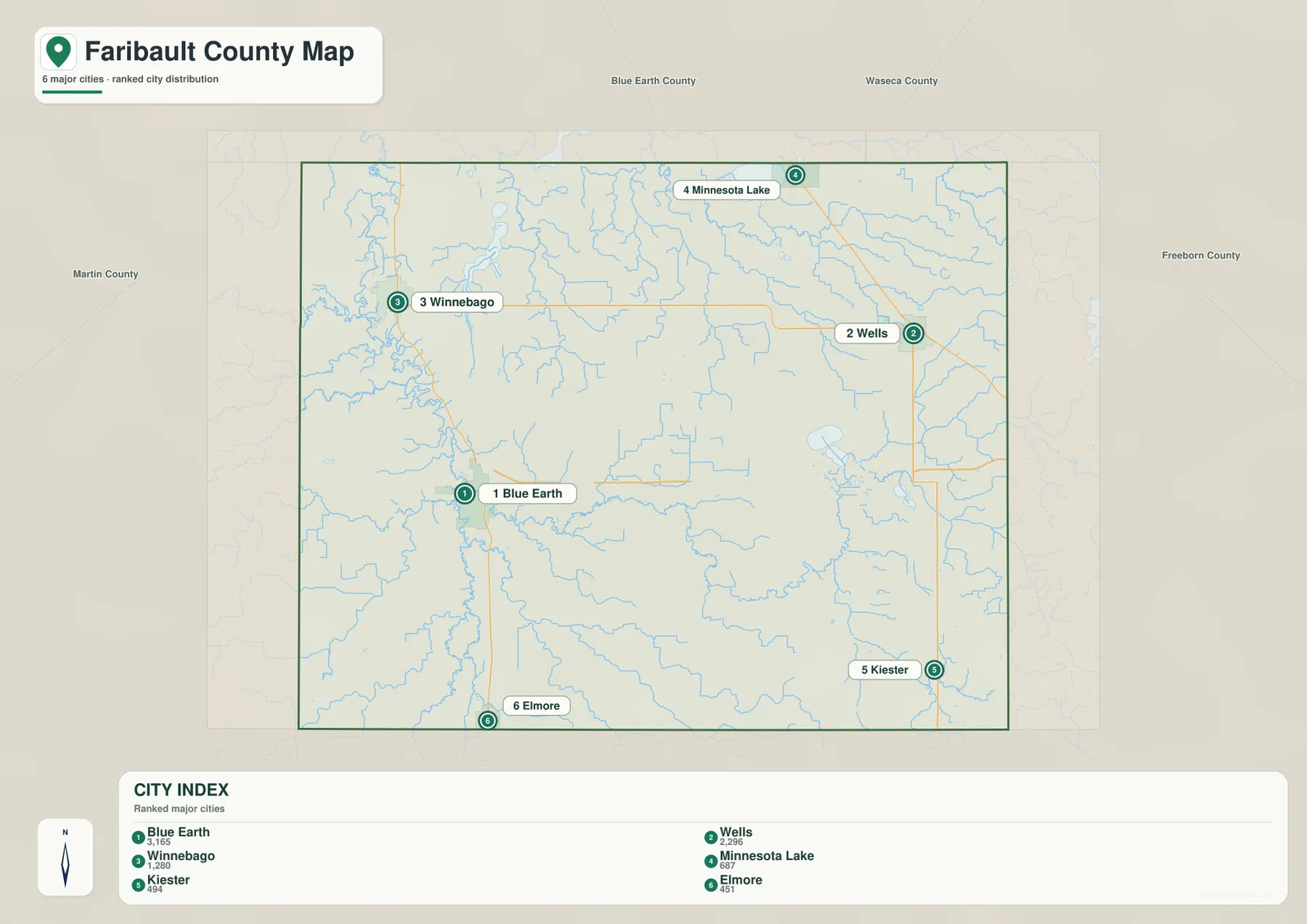
The map’s city index lists Blue Earth at 3,165, Wells at 2,296, Winnebago at 1,280, Minnesota Lake at 687, Kiester at 494, and Elmore at 451. Those values belong to the map’s source index and should be treated as reference figures rather than assumed to be current official population estimates. Even without relying on the numbers as current statistics, the map clearly presents Blue Earth and Wells as the two larger settlement centers among the six highlighted places.
For a classroom slide or a simple county overview, this stripped-down city view is often easier to read than the full road map. When the goal changes to explaining how the communities connect, the general county map becomes more useful. Highway 169 links Winnebago with the Blue Earth area, Route 21 helps connect Easton and Wells, and Highway 22 continues south from Wells toward Kiester. Using both maps keeps city location and travel routes from being mixed together.
The Blue Earth River and its southern branches
The strongest water feature on the Faribault County terrain-and-water map is the Blue Earth River. It bends along the western side of the county and creates a recognizable low corridor through the otherwise broad rural landscape. Around the Blue Earth area, smaller tributaries join the river, and farther south the map labels the Middle Branch Blue Earth River and the West Branch Blue Earth River. Their winding courses contrast sharply with the straight road grid visible on the general map.
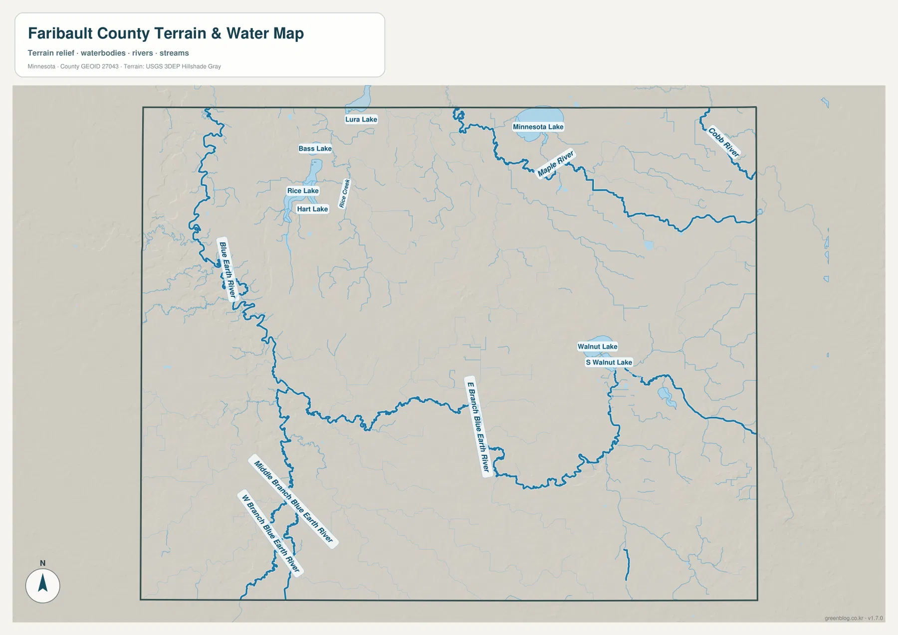
An East Branch Blue Earth River is also labeled across the south-central and southeastern part of the county. Near the eastern half, Walnut Lake and South Walnut Lake provide useful fixed points for reading the local drainage pattern. In the northwest, Rice Lake, Hart Lake, and Bass Lake cluster relatively close together, with Lura Lake farther north. These lakes are modest compared with Minnesota’s large lake districts, but they add important local references in a county where many smaller streams otherwise dominate the water map.
Faribault County’s official water management plan describes most of the county as lying within the Blue Earth River and Le Sueur River watersheds. The map on this page is not a detailed watershed-boundary product, but it does show why the county cannot be understood as a single drainage channel. Western and southern branches feed the Blue Earth River system, while northern and northeastern streams head in other directions. Flood risk, ditch management, water quality, or parcel-level drainage should be checked with current official resources designed for those purposes.
Minnesota Lake, Maple River, and the northeastern drainage
The northeastern corner has a different water pattern. Minnesota Lake sits close to the north edge of the county, and the Maple River bends through the area to its southeast. Near the eastern boundary, the Cobb River is also labeled. Numerous smaller tributaries extend toward these larger channels, creating a drainage network that looks quite different from the deeply curving Blue Earth River corridor on the west side.
The shared name “Minnesota Lake” can refer to the community and to the nearby lake, so it is worth keeping the two map symbols separate. The city map highlights Minnesota Lake as one of the six ranked communities, while the terrain-and-water map emphasizes the waterbody and the surrounding drainage. Using the two views together prevents a place label from being mistaken for a lake label when preparing a report, worksheet, or presentation.
Walnut Lake and South Walnut Lake form another useful pair of landmarks farther south and east. Their position is close to the road corridor between the Wells and Kiester areas, and several minor streams connect through the surrounding landscape. The water map is intended to show broad geographic relationships, not boating access, depth, fishing rules, or real-time water conditions. Those questions require current information from the Minnesota Department of Natural Resources or the appropriate local authority.
A 302-436 meter range with the highest ground in the southeast
The elevation map labels an actual county range of roughly 302 to 436 meters, with a mean near 340 meters. The western Blue Earth River corridor and parts of the northwest are shown in darker green, indicating lower terrain. Moving eastward, the colors generally become lighter, and the southeast contains a large orange-brown area that stands out as the county’s strongest high-ground feature. The contrast is substantial enough to be visible even though Faribault County has no mountainous terrain.
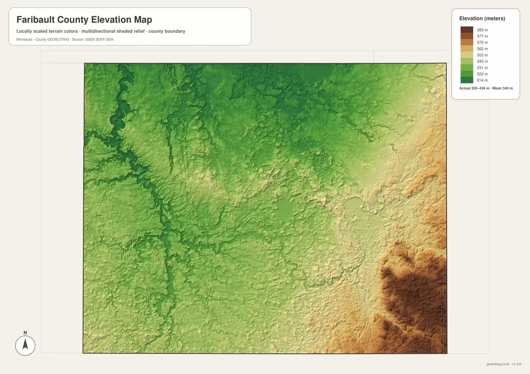
The relationship between rivers and relief is easiest to see on the western side. The Blue Earth River and its tributaries follow lower bands, while gently higher ground lies between the channels. Across the central part of the county, the terrain is rolling rather than sharply rugged. The rise becomes more obvious toward the east and southeast, where the warm elevation colors spread over a much larger area than they do around Blue Earth and the western boundary.
This surface is appropriate for county-scale comparison, not for engineering or survey work. A property owner should not use it to determine the exact elevation of a house, field corner, culvert, or drainage structure. Those tasks require more detailed elevation data or professional measurement. For general geography, however, the map is an effective way to explain why the river corridors sit lower and why the southeast appears different from the western half of the county.
What changes when roads, rivers, and relief are viewed together
The road network can make Faribault County look almost uniformly gridded at first glance. Adding the waterways and elevation maps changes that impression. Streams weave between the straight roads, the Blue Earth River creates a distinctly lower western corridor, and the southeast rises above much of the rest of the county. Near Blue Earth, Highway 169 and the river occupy the same broad part of the county without following identical paths. Around Wells and Kiester, the map places communities and roads closer to the higher eastern terrain.
The same combined approach helps with the northern towns. Winnebago, Delavan, and Easton are easy to line up along Route 17 on the general map, but the water map shows that the surrounding drainage varies considerably from west to east. Closer to Minnesota Lake, the Maple River system becomes more important, while the northwest is influenced more strongly by the Blue Earth River and nearby small lakes. Associating each town with one nearby river, lake, or road makes the county easier to remember than memorizing a list of place names.
The Iowa line provides another strong geographic reference in the south. Elmore and Kiester sit close to that boundary, with broad rural land and several Blue Earth River branches between them. The elevation map also shows that southern Faribault County is not all at one level: the southeast is noticeably higher than the lower western river country. That distinction is useful in regional descriptions because it avoids treating the entire county as a featureless plain.
Choosing the right Faribault County map for the task
Use the general county map when towns and numbered roads need to appear together. It is the best choice for locating Blue Earth, Wells, Winnebago, Easton, Kiester, or Elmore in relation to the county boundary and major routes. The city map is cleaner when only settlement positions matter. Its simplified presentation works well in slides, school projects, or graphics where too many road and stream labels would distract from the main point.
For natural geography, the water map contains the most direct information. It brings the Blue Earth River branches, Maple River, Cobb River, and named lakes forward while reducing the visual importance of roads. Add the elevation map when the relationship between drainage and land height matters. The contrast between the western lowlands and the southeast uplands is much clearer there than on the general county map.
For printed handouts, choosing one or two maps for a specific purpose usually produces a more readable page than shrinking all the information into one graphic. A road-and-city overview can use the general map, while a natural-resources lesson can pair the water and elevation maps. Because all four files use the same county boundary, readers can move between them without relearning the outline or orientation.
Why waterways matter in an agricultural county
Faribault County’s official water management plan describes the county as primarily agricultural, with extensive farm acreage and a long history of water-management planning. The maps on this page do not classify land cover or show individual farm parcels, but they do provide useful geographic context. Outside the towns, the road map is relatively open, while the water map reveals a dense set of streams and branches crossing that same rural space.
The Blue Earth River and its branches are especially important to this broader picture. On the elevation map, many river and tributary corridors correspond with lower terrain, while the land between them rises gently. This is one reason a county that may look flat on a road map gains much more structure when relief and drainage are added. For local history, agriculture, or environmental education, the combination of maps gives a more complete geographic introduction than a settlement map alone.
Conditions involving water quality, drainage systems, flooding, or field management can change and may depend on information not shown here. These maps are static reference products for location and regional interpretation, not operational tools for farming or emergency decisions. The official county and federal sources listed below are better starting points when more detailed or current data are required.
Frequently Asked Questions
Which map is best for comparing Blue Earth and Wells?
The general county map is the most useful because it shows both communities together with the surrounding highways. Blue Earth is in the southwest-central area and Wells is farther east, while Routes 90, 169, 21, 22, and 109 provide road context. If only the relative city positions are needed, the simplified city map is easier to read.
What is the most prominent river on the Faribault County water map?
The Blue Earth River is the strongest river feature, especially along the western side of the county. Its east, middle, and west branch system is also labeled farther south. In the northeast, the Maple River and Cobb River provide separate major water references.
Can the 302-436 meter elevation range be used for surveying?
No. The elevation map is a generalized county-scale surface meant to compare higher and lower areas. Construction, drainage design, property surveying, and other precise tasks require detailed elevation data or professional field measurements.
Map File Information
The four high-resolution JPG maps used in this article are available together in one ZIP file.
- Included Files: county map, city map, water map, elevation map
- Printable Size: 3638 × 2572 px for each JPG
- File Type: ZIP containing 4 JPG images
Related Maps
Sources and references
- Faribault County official website – county government and local information
- Faribault County Local Water Management Plan – county water, watershed, and land-use background
- U.S. Census Bureau TIGER/Line Shapefiles – boundary, road, and place data
- USGS National Hydrography – rivers, streams, and water features
- USGS 3D Elevation Program – elevation data and products
Green Map creates custom-edited map images using open geographic data sources such as geoBoundaries, Natural Earth, OpenStreetMap, and government open data. These maps are edited visual materials, not raw data files, and are provided for education, documents, presentations, and graphic reference.