Cobb County sits immediately northwest of Atlanta, with Marietta near the center and a group of incorporated cities extending toward the Allatoona Lake area, the Chattahoochee River side of the county, and the western suburbs. The maps on this page separate four kinds of information that are easy to confuse on a single image: the county boundary and major roads, the distribution of selected cities, named rivers and creeks, and terrain height. You can download four original A3 high-resolution JPG maps together in one ZIP. The larger files are intended for printing, classroom work, presentations, and local-reference documents, while the WebP images on the page serve as previews.
A useful way to orient yourself is to start with Marietta and then look outward. Kennesaw and Acworth lie to the northwest, Smyrna is southeast of Marietta, Powder Springs is southwest, and Mableton occupies the southern part of the county. The eastern edge follows the Chattahoochee side of metropolitan Atlanta, while the northwestern corner reaches the Allatoona Lake area. Those directions become much clearer when the road map is compared with the water and elevation maps rather than read in isolation.
Table of Contents
Cobb County’s boundary, road network, and Atlanta-side location
Cobb County is bordered by Fulton County along much of the east and southeast, Cherokee County to the north, Bartow County to the northwest, Paulding County to the west, and Douglas County to the southwest. Its outline is broad across the north and middle, then narrows into a pointed southern section. The inset on the county map places Cobb in north-central Georgia, while the main map shows how closely the eastern and southern parts of the county sit to Atlanta and other Fulton County communities.
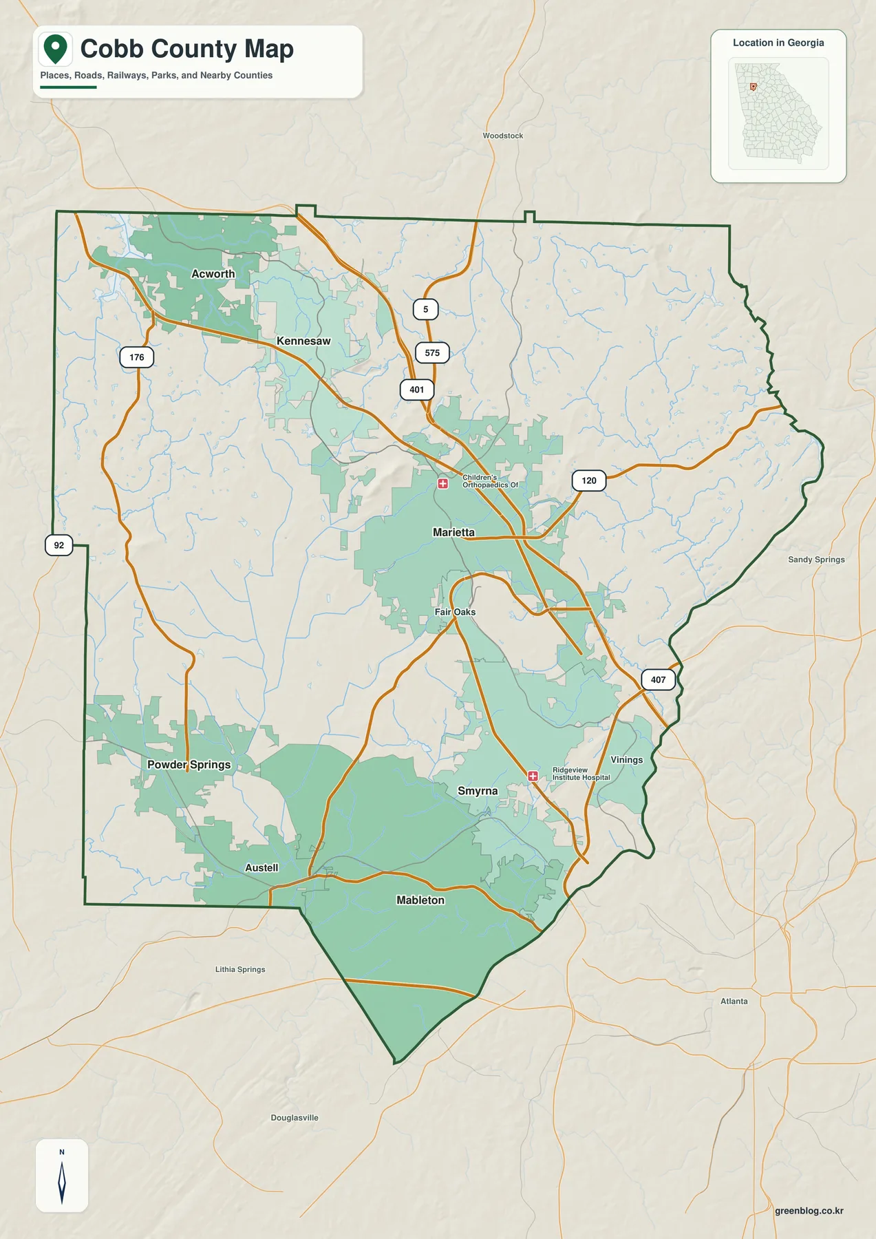
The main transportation pattern is easy to recognize even before looking at smaller roads. The preserved county material identifies I-75 as the principal north-south interstate through the Cumberland and Marietta corridor, with I-575 branching north toward Cherokee County. I-285 crosses the southeastern side of Cobb as part of Atlanta’s beltway, and US 41, commonly called Cobb Parkway, links Smyrna, Marietta, Kennesaw, and Acworth. Route numbers such as 120, 92, and 176 also appear on the supplied map and help fill in the local east-west and western connections.
Marietta works well as a geographic anchor because it is near the middle of the county and is the county seat. From there, the northwest route pattern leads toward Kennesaw and Acworth; the southeast side opens toward Smyrna, Cumberland, and the Fulton County line; the southwest side leads toward Powder Springs and Austell; and Mableton lies in the southern sector. Cobb therefore does not read like a county with one isolated town and a large rural hinterland. It is a set of connected urban and suburban districts whose road access and neighboring counties differ by direction.
| State | Georgia |
|---|---|
| County | Cobb County |
| County seat | Marietta |
| Six cities ranked on the city map | Mableton, Marietta, Smyrna, Kennesaw, Acworth, Powder Springs |
| Additional incorporated city visible on the county map | Austell |
| Major road context | I-75, I-285, I-575, US 41 and state routes |
| Key water features | Chattahoochee River, Allatoona Lake, Noonday Creek, Sope Creek, Sweetwater Creek |
| Elevation shown on the map | about 167–544 m · mean about 303 m |
| Download | four A3 high-resolution JPG maps in one ZIP |
The existing source set also provides useful scale. The U.S. Census Bureau estimate cited in the preserved article is 793,345 residents for 2025, compared with 766,149 in the 2020 census. It lists 339.78 square miles of land and a 2020 density of 2,254.8 people per square mile. Those countywide figures help explain why city labels and major roads are so important on a Cobb map, but they should not be treated as population figures for Marietta, Mableton, or any other individual municipality.
From Mableton and Marietta to Kennesaw and Acworth
The city map highlights six communities with numbered markers rather than attempting to label every named place in Cobb. Mableton is shown as number 1 in the south, Marietta as number 2 near the center, Smyrna as number 3 to the southeast, Kennesaw and Acworth as numbers 4 and 5 in the northwest, and Powder Springs as number 6 in the southwest. This layout makes the county’s multi-directional settlement pattern obvious: the major communities are spread across several corridors instead of following one simple line.
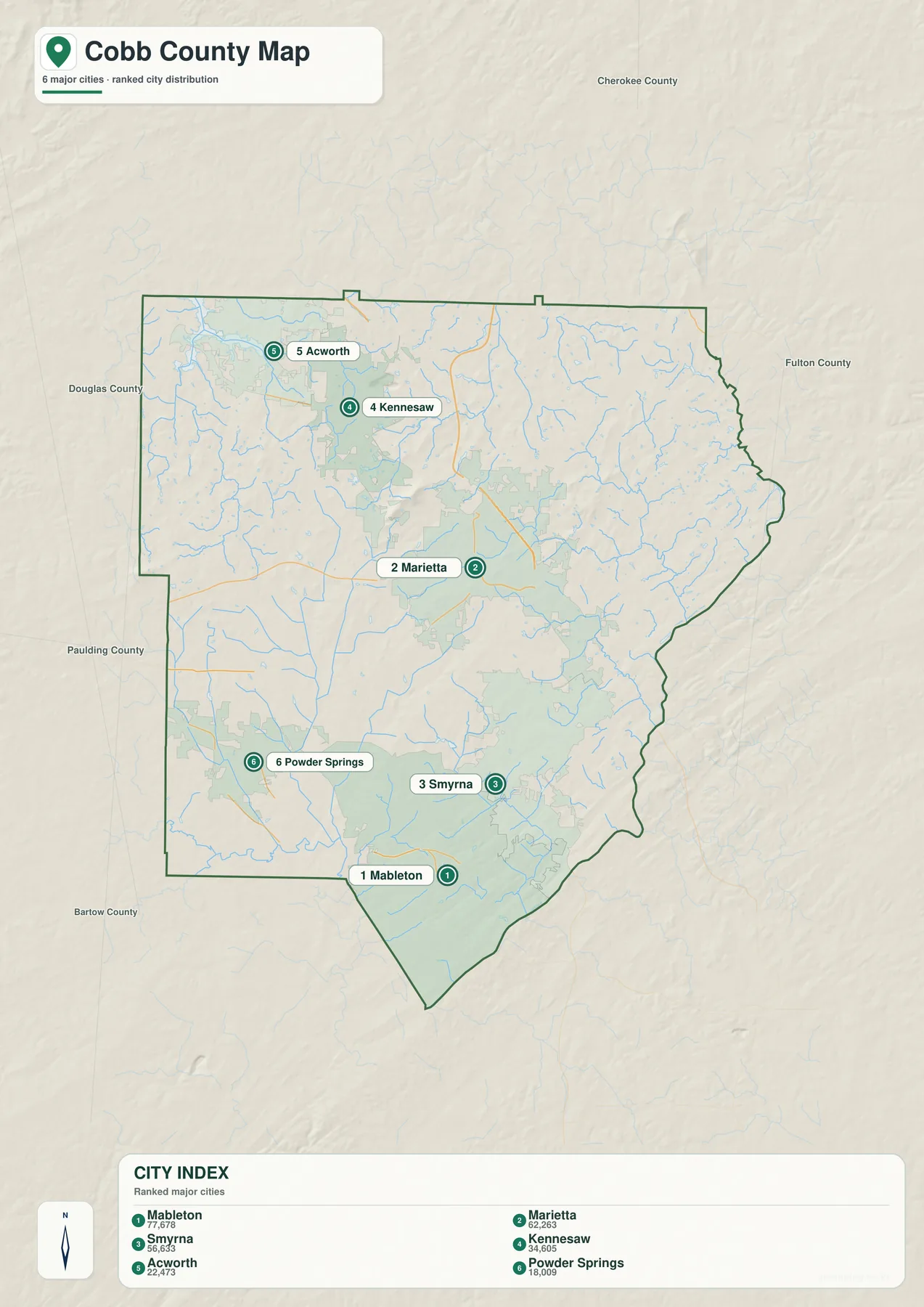
The index printed on the supplied map lists Mableton at 77,678, Marietta at 62,263, Smyrna at 56,633, Kennesaw at 34,605, Acworth at 22,473, and Powder Springs at 18,009. These are values presented on the map itself and are best treated as part of that map snapshot; use a current Census Bureau or municipal source when you need the latest official estimate. The ranking numbers are labels for quick comparison, not distances, city-area measurements, or municipal boundary sizes.
The existing Cobb County Government material preserved with this package lists seven incorporated cities. Austell is not one of the six ranked cities on this particular city map, but it is labeled on the broader county map. That distinction matters because a simplified city-distribution map can omit a smaller incorporated place without changing its legal status. The same caution applies in the other direction: East Cobb, Vinings, and Cumberland are widely used local names, yet they should not automatically be treated as incorporated cities simply because residents and businesses use those names.
Northwestern Cobb has a particularly clear pairing of Kennesaw and Acworth. They sit near the Allatoona side of the county and close to the Cherokee and Bartow directions. Marietta occupies a more central position, while Smyrna is oriented toward the Atlanta side of the county. Mableton and Austell help define the south, and Powder Springs gives the southwest its own identifiable center. For someone learning the county for the first time, comparing these positions is often more useful than memorizing a list of city names.
The settlement pattern also has historical depth. The preserved county background says Cobb was created in 1832 and Marietta became the county seat in 1834. Kennesaw developed from the rail settlement known as Big Shanty, and other communities grew around nineteenth-century transport and local commerce. The 1864 Battle of Kennesaw Mountain is one of the best-known episodes in the county’s history. Later highways and metropolitan suburbanization changed the scale of settlement, but the older town centers and the rolling Piedmont landscape remain visible parts of Cobb’s geography.
Allatoona Lake, the Chattahoochee River, and Cobb’s creek network
The water map shows why Cobb cannot be described by one river basin. Allatoona Lake appears at the northwestern edge, while the Chattahoochee River follows the eastern side of the county. Between them, a network of creeks divides the interior into smaller valleys. The two large water features are both important reference points, but they are not part of the same river system.
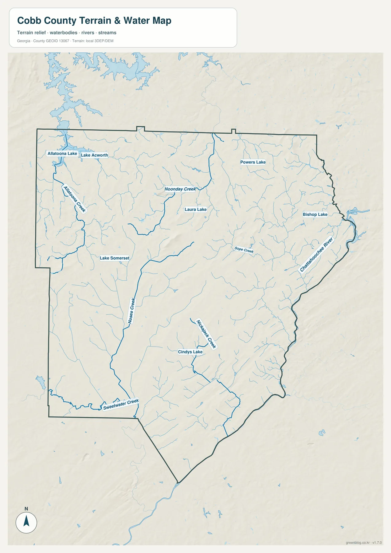
In the northwest, Allatoona Lake and Lake Acworth are labeled close together, with Allatoona Creek running through the western part of the county. Noonday Creek is prominent across the northern interior. On the eastern side, Sope Creek heads toward the Chattahoochee River, and the map also shows Bishop Lake near that side of the county. Farther south, Nickajack Creek, Sweetwater Creek, and several smaller tributaries help define the lower valleys. Moses Creek is labeled through the central-western part of the map.
Several smaller lakes are named as well, including Powers Lake, Laura Lake, Lake Somerset, and Cindy’s Lake. Their presence is useful for local orientation, especially in areas where roads and subdivisions create a dense visual background. The map is not a flood-hazard product, however. A blue line shows a mapped water feature, not a determination that nearby property is inside a regulatory flood zone, and the absence of a small drainage feature should not be taken as proof that no drainage issue exists.
The preserved background explains the larger watershed divide. Sope Creek and other eastern tributaries drain toward the Chattahoochee River and the Apalachicola–Chattahoochee–Flint system. Noonday Creek in northern Cobb continues toward the Little River and Allatoona Lake, connecting it with the Etowah–Coosa system. Sweetwater Creek provides another southwestern reference. Rain falling within one county can therefore leave Cobb through distinctly different basin routes, which is one reason the elevation map is worth comparing with the water map.
Two official recreation areas also help anchor the water geography in the preserved sources. National Park Service material covers the Chattahoochee River National Recreation Area and the Sope Creek area along Cobb’s eastern side. U.S. Army Corps of Engineers material covers Allatoona Lake and its shoreline. Those resources are useful when a general county map needs to be supplemented with current recreation, shoreline, or site-specific information.
Ridges and stream valleys across a 167–544 meter elevation range
The elevation map reports an actual Cobb County range of about 167 to 544 meters, with a mean near 303 meters. Cobb is not a mountain county in the sense of the Blue Ridge counties farther north, but the terrain is far from flat. Long ridges, rounded uplands, and narrow stream valleys repeat across the map. Higher brown and tan terrain is concentrated along many interior ridges, while greener low areas appear along the Chattahoochee edge and in several creek valleys toward the south and west.
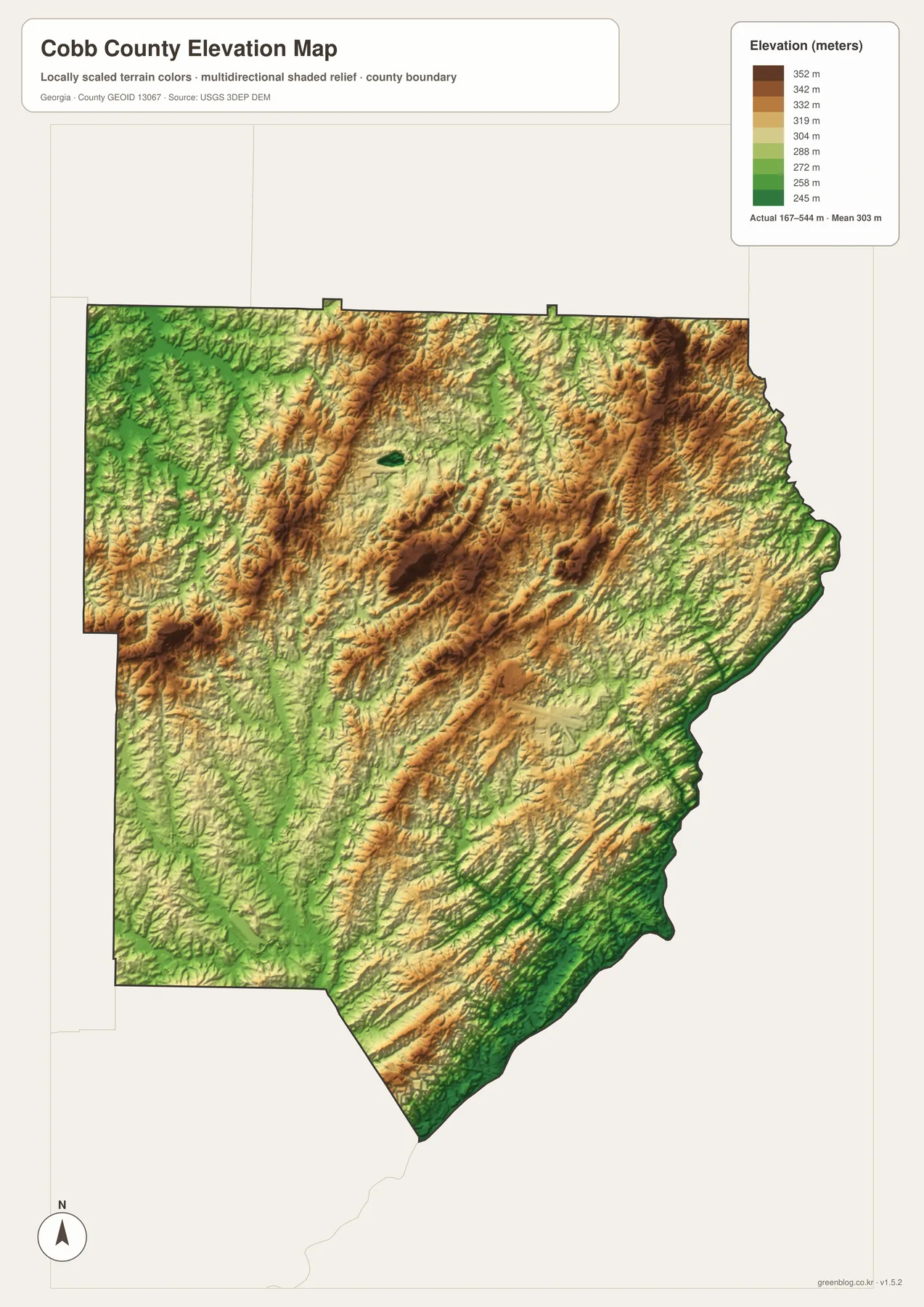
Reading this map beside the hydrography map makes the relief easier to understand. Noonday Creek and Allatoona Creek occupy lower paths between uplands in the north and west. The eastern tributaries descend toward the Chattahoochee River, where the county edge is generally lower than many interior ridges. Nickajack Creek and Sweetwater Creek also follow lower corridors through the southern half of the county. The terrain colors therefore help explain the direction of several waterways without requiring a technical contour map.
Kennesaw Mountain provides a familiar historical reference for the county’s stronger relief. The preserved article notes that the 1864 battle there was a major action in the Atlanta Campaign and that the surrounding ridges illustrate the rolling Upper Piedmont landscape. The modern road network and suburban development can make Cobb appear uniformly urban on a street map, but the elevation surface shows that neighborhoods and roads are still laid across a landscape of repeated ridges and valleys.
This elevation image is intended for county-scale comparison, not site engineering. It is useful for seeing which parts of the county are generally higher, where valley corridors cut through the uplands, and how the river edge differs from interior ridges. It should not be used as a survey, a building-site elevation certificate, or a drainage-design measurement. For precise elevation work, use the underlying USGS 3D Elevation Program data or a professional field survey.
What becomes clearer when the four maps are compared
The strongest use of this set is not to force every question onto one image. Start with the county map when you need boundaries, major roads, and general place names. Switch to the city map when the goal is to compare the positions of Mableton, Marietta, Smyrna, Kennesaw, Acworth, and Powder Springs. Use the water map for named rivers, creeks, and lakes, then bring in the elevation map when you want to see whether those waterways follow lower ground between ridges.
Following the route from Marietta toward Kennesaw and Acworth shows how the maps build on one another. The county map establishes the northwestern transport direction, while the city map places Kennesaw and Acworth along the same general corridor. Adding the water map brings Noonday Creek and the approach to Allatoona Lake into view, and the elevation map shows that the route crosses a landscape of ridges and valleys rather than a flat suburban plain. Together, those layers explain the corridor more clearly than a city list or road map alone.
The southeastern side offers a different example. Smyrna sits closer to Atlanta and the Fulton County line, with the I-75/I-285 context described in the preserved article. On the water map, Sope Creek and the Chattahoochee River become the main natural references. The elevation image then shows the lower river-side terrain against higher interior ridges. These layers help explain why two places that are both called “Cobb County” can feel quite different in their road pattern, topography, and relationship to Atlanta.
The southern part also demonstrates why map purpose matters. Mableton is one of the six ranked cities on the city map, while Austell is visible on the broader county map but not in that six-city ranking. That is not a contradiction; it reflects different levels of selection. A map that emphasizes the largest or most prominent places may omit a smaller incorporated city, just as a water map may omit minor drainage channels. Always read the title, legend, and map purpose before treating an omission as a statement about legal status.
Using the Cobb map files for print, study, and local reference
These maps are designed as accessible county references rather than legal or engineering documents. A community presentation can use the county map to show where Marietta and the surrounding cities sit in relation to Atlanta. A classroom lesson can pair the city and water maps to compare settlement with natural drainage. A local history project can add the elevation map when discussing Kennesaw Mountain, early rail communities, or the way ridges and creek valleys influenced movement.
- County orientation: compare Marietta with Acworth, Kennesaw, Smyrna, Mableton, Powder Springs, and Austell.
- Transportation context: relate the major communities to I-75, I-285, I-575, US 41, and the numbered state routes shown on the map.
- Water study: locate Allatoona Lake, the Chattahoochee River, Noonday Creek, Sope Creek, Sweetwater Creek, and smaller named lakes.
- Terrain comparison: use the 167–544 meter elevation range to distinguish higher ridges from lower stream corridors.
- Print work: use the four A3 high-resolution JPG originals from the ZIP when a larger image is needed.
For jurisdictional or property decisions, use a more specialized source. The county outline does not substitute for parcel boundaries, zoning, school attendance zones, voting districts, municipal service areas, or utility boundaries. The water map is not a FEMA flood map, and the elevation map is not survey-grade. Current navigation, road closures, and emergency response also require live services. Keeping those limits clear makes the files more useful because readers can use them confidently for the purposes they were actually designed to serve.
Cobb’s history can also be explored by pairing the maps with the preserved reference links. Marietta’s role as county seat, Kennesaw’s railroad origins and Civil War history, the Chattahoochee recreation corridor, and Allatoona Lake all occupy different parts of the same county. Seeing those places together helps explain how a nineteenth-century county evolved into a densely settled part of metropolitan Atlanta while retaining a varied landscape of ridges, creek valleys, river frontage, and reservoir shoreline.
Frequently Asked Questions
Which cities are shown on the Cobb County city map?
The ranked city map shows Mableton, Marietta, Smyrna, Kennesaw, Acworth, and Powder Springs. Austell is visible on the broader county map, and the preserved Cobb County Government material lists seven incorporated cities in total. The six ranked markers therefore should not be read as the complete legal list of municipalities.
Are Allatoona Lake and the Chattahoochee River part of the same watershed?
No. The preserved source material places Noonday Creek and the Allatoona Lake side in the Etowah–Coosa drainage, while Sope Creek and the Chattahoochee side belong to the Apalachicola–Chattahoochee–Flint system. Cobb therefore contains a significant divide between waterways that leave the county by different basin routes.
What elevation range is shown for Cobb County?
The supplied elevation map reports an actual range of about 167 to 544 meters and a mean of about 303 meters. It is useful for comparing ridges and lower creek or river valleys across the county, but it is not a replacement for survey-grade elevation data at a specific property or construction site.
What is included in the downloadable ZIP?
The ZIP contains four original A3 high-resolution JPG files: a county and road map, a ranked city map, a water map, and an elevation map. They are larger than the WebP previews on the page and are intended for general printing, presentations, educational use, and local-reference documents.
Map File Information
Cobb County high-resolution map files
- Included Files: County map, city map, water map, and elevation map
- File Type: Four original A3 high-resolution JPG files in one ZIP
- Intended Use: Printing, education, presentations, and local-reference projects
Related Maps
Sources and references
Population and county background are based on the source set already preserved in the package. Water and terrain descriptions are limited to the supplied maps and the official reference links included with the current article. Check the date on the original agency page before using a figure or boundary for a current legal or administrative decision.
- U.S. Census Bureau QuickFacts: Cobb County, Georgia
- Cobb County Government: county history and overview
- Cobb County Government: current incorporated-city information
- National Park Service: Chattahoochee River National Recreation Area maps
- U.S. Army Corps of Engineers: Allatoona Lake
- USGS 3D Elevation Program
Green Map creates custom-edited map images using open geographic data sources such as geoBoundaries, Natural Earth, OpenStreetMap, and government open data. These maps are edited visual materials, not raw data files, and are provided for education, documents, presentations, and graphic reference.