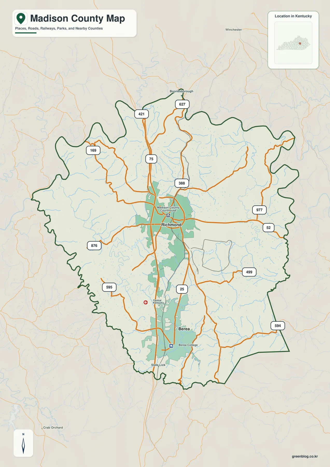
Madison County stretches across central Kentucky from the Kentucky River hills in the northwest to much higher ridges along the southern and southeastern edge. Richmond occupies the central part of the county, Berea anchors the south, and I-75 provides the clearest north-south transportation line between them. The maps on this page also show Boonesborough, major numbered roads, Lake Reba, Wilgreen Lake, a dense creek network, and a countywide elevation range that becomes especially rugged near the southern boundary. High-resolution JPG versions of the maps are available together in a ZIP archive for printing, classroom work, presentations, and offline reference. High-resolution map files are available for download in the section below.
The county has two distinct urban reference points rather than one compact settlement cluster. Richmond contains the Madison County Courthouse marker and the largest developed area on the map, while Berea appears farther south near Berea College. Between and around those cities, tributaries cut through rolling terrain in nearly every direction. The Kentucky River creates a strongly incised western and northwestern edge, whereas the southern part rises into higher ridge country. Comparing roads, water, and elevation therefore gives a much fuller picture than viewing the city locations alone.
Table of Contents
I-75 connects Richmond and Berea through the county center
Richmond is the easiest starting point on the general county map. I-75 runs north-south through the city area, and routes 388 and 52 extend toward the east and west. Routes 421 and 627 appear farther north near the Boonesborough side, while 169 and 876 cross the western part of the county. Route 977 reaches toward the eastern boundary. Together these roads show a central network focused on Richmond with longer rural connections spreading into the surrounding hills.
South of Richmond, route 25 follows a similar general direction to I-75 toward Berea. The map marks Central Kentucky Regional between the two urban areas, and Berea College provides a clear landmark within Berea. Routes 499 and 594 extend through the southeastern side, while Slate Lick appears near the southern edge. The built-up corridor between Richmond and Berea is visually obvious, but it occupies only part of the county; creeks, wooded hills, and rural roads become dominant only a short distance away.
Boonesborough provides a useful northern reference near the Kentucky River. Routes 421 and 627 pass through that part of the map, and the county outline becomes much more irregular as it approaches the river valleys. The western boundary is similarly winding, reflecting the deeply cut terrain beside the Kentucky River rather than a simple straight administrative line. Outside the county, Winchester and Crab Orchard labels help orient the broader regional position.
The general map is the best single view for combining settlements, roads, county boundaries, and major landmarks. It is not intended for live routing, construction notices, or current travel times. In the western river hills and southern ridges especially, road distance can be substantially longer than a straight-line measurement because routes must follow valleys and crossings.
Richmond and Berea define a two-city settlement pattern
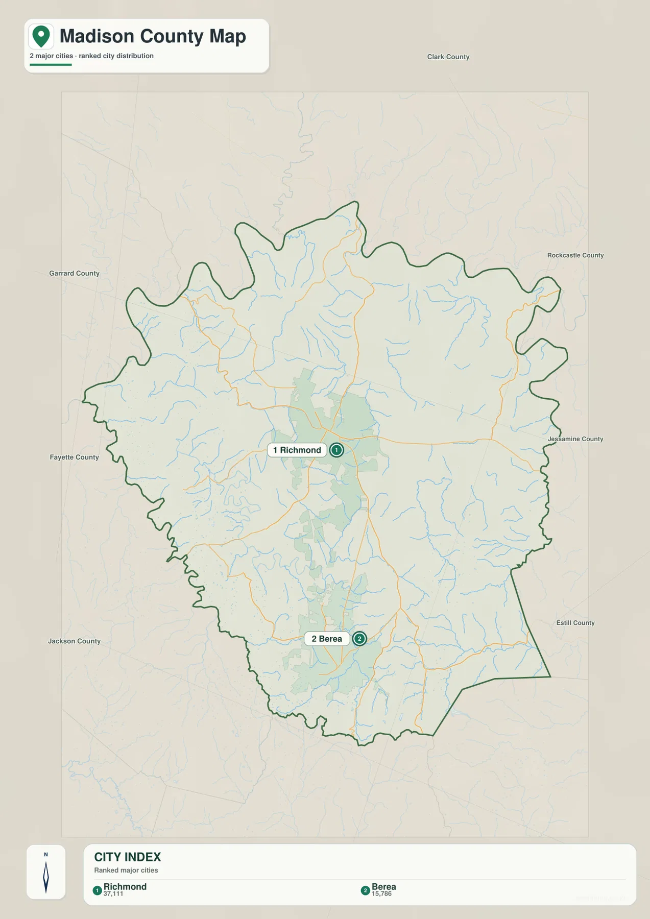
The city-distribution map ranks Richmond first and Berea second. The supplied map labels Richmond with a population of 37,111 and Berea with 15,786. Both cities lie near the central north-south corridor, but they are separated enough to create two distinct urban areas rather than one continuous city center. Kentucky’s official Madison County profile also describes Richmond and Berea as the county’s two incorporated cities, matching the settlement pattern shown here.
Richmond sits near the geographic and transportation center of the county. Its developed area is larger on the map, and several roads radiate toward the north, east, west, and south. Berea is a separate southern center linked by I-75 and route 25, with Berea College marked inside the city. The corridor between the cities contains additional development, but the county broadens considerably on both sides into rural hills and creek valleys.
Outside Richmond and Berea, the map does not show another ranked major city. Northern, eastern, and western sections are instead defined by smaller roads, streams, and changing terrain. Near the Kentucky River, the river valley itself becomes a stronger location cue than an urban label. In the southeast, ridges and creeks provide the most useful geographic references, which is why the city map works best as an introduction rather than a complete picture of Madison County.
Kentucky River valleys give way to Lake Reba and southern creeks
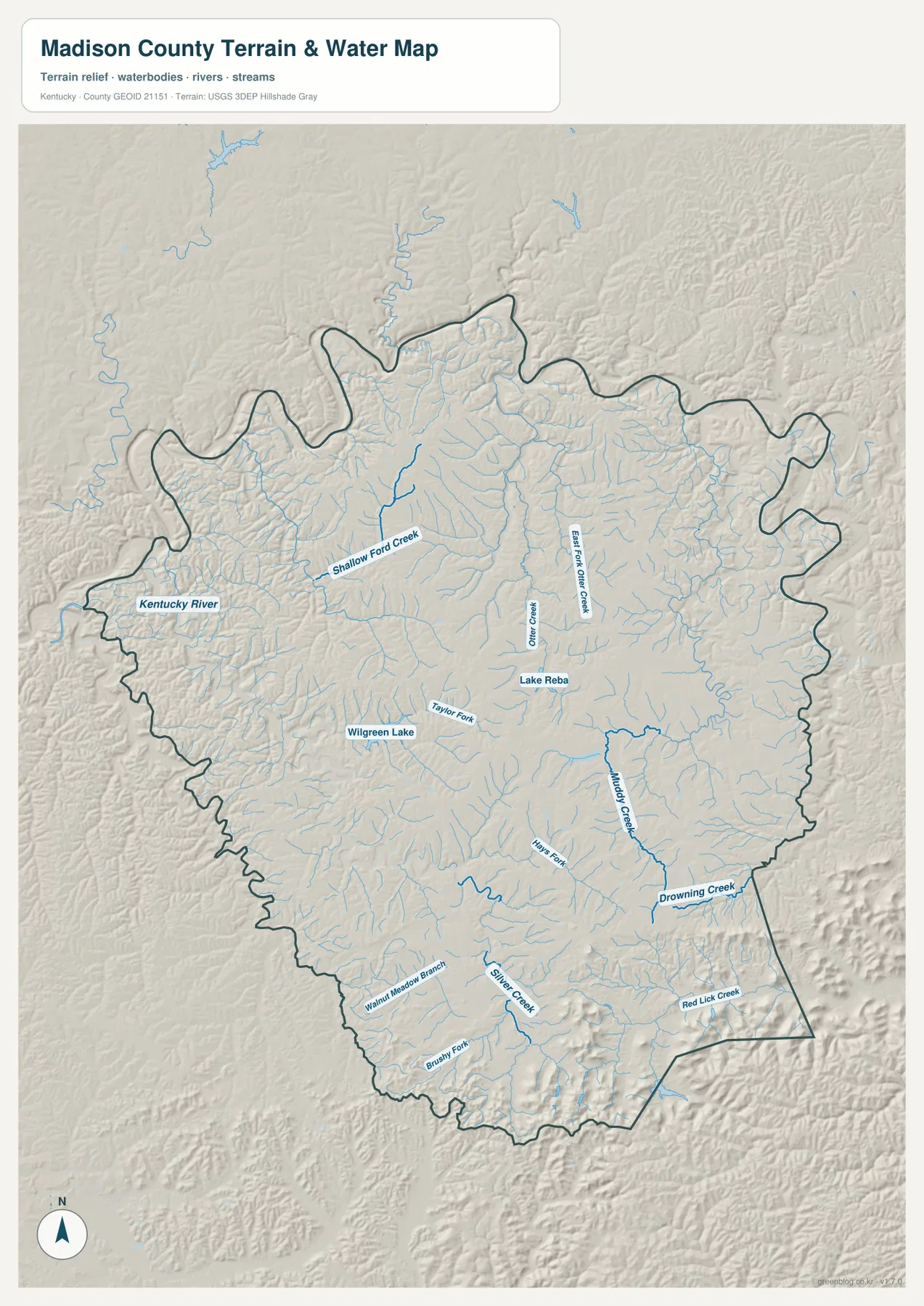
The Kentucky River is the largest water feature on the terrain-and-water map, following the western and northwestern side of the county through a deeply incised valley. Shallow Ford Creek reaches inward from that side toward the north-central interior. East Fork Otter Creek and Otter Creek are labeled near the Richmond area, and Lake Reba provides a clear water landmark east of the city. These features show that even the central urban part of Madison County is surrounded by a dense network of tributary valleys.
Southwest of Richmond, Wilgreen Lake is another recognizable water body, with Taylor Fork nearby. Farther southeast, Muddy Creek becomes one of the strongest named drainage lines on the map, and Drowning Creek appears closer to the southeastern boundary. Red Lick Creek, Silver Creek, Brushy Fork, Walnut Meadow Branch, and Horse Fork mark additional valleys across the southern part of the county. Their locations correspond closely to low corridors visible on the elevation map.
The western Kentucky River side has the most deeply cut valley scenery on the shaded-relief surface. The Richmond-Berea corridor contains more development but is still crossed by Taylor Fork and many smaller tributaries. In the southeast, the drainage network occupies narrower valleys between higher ridges. Those differences give the county several distinct physical settings: a major river edge, a rolling central corridor, and elevated southern creek country.
This physical map is intended for geographic orientation rather than current water conditions. It does not show flood stage, water depth, water quality, fishing rules, or private access. Current safety or recreation decisions should rely on the agencies responsible for local waterways and public access.
A 164–511 meter range rises sharply toward the southern boundary
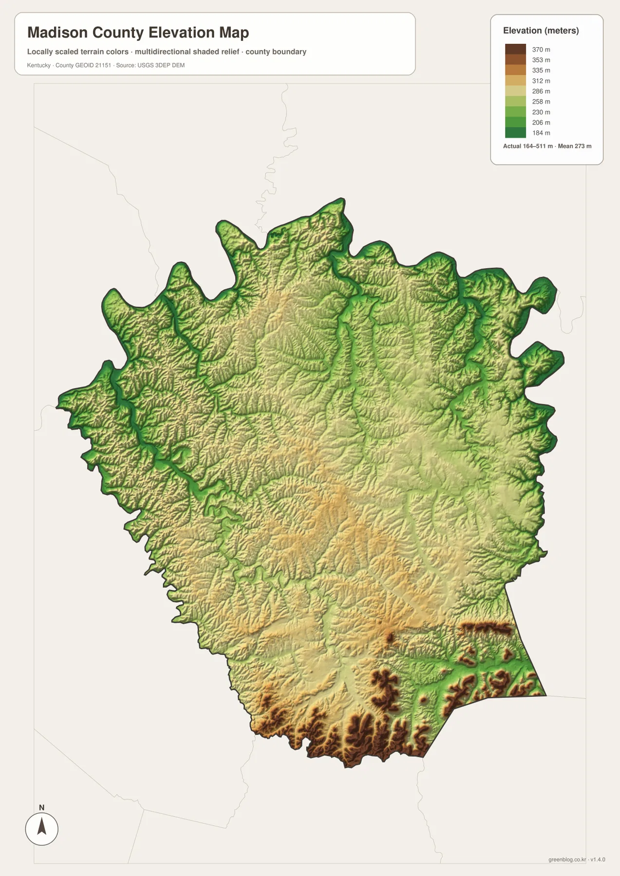
The elevation map reports an actual county range of approximately 164 to 511 meters and a mean near 273 meters. The highest brown terrain is concentrated along the southern and southeastern edge, where steep ridges rise well above the central county. Yellow and light-green terrain dominates much of the middle, while the Kentucky River and major creek valleys appear as lower green corridors. With more than 300 meters between the mapped low and high points, Madison County has a much stronger relief contrast than the road map alone suggests.
The southern highlands are not a single flat plateau. Dark ridges are separated by narrow lower valleys that line up with Brushy Fork, Silver Creek, Red Lick Creek, and other tributaries on the water map. South of Berea, elevation changes become especially pronounced. Comparing the physical maps shows why the southern edge looks rugged: streams occupy narrow cuts while the land between them rises into repeated ridge crests.
Richmond sits in lower, rolling terrain compared with the southern boundary, although the city is not surrounded by a flat plain. Small ridges and creek valleys remain common to the west and north, and elevation drops sharply toward the Kentucky River. The eastern side also contains rolling uplands dissected by drainage lines, with higher ground becoming more frequent toward the southeast. I-75 and route 25 therefore pass through a central corridor positioned between several different terrain zones.
The elevation colors are intended for county-scale comparison, not parcel surveying. They are useful for distinguishing river valleys, rolling uplands, and high southern ridges, but they do not provide survey-grade elevation for a property, road, building site, or drainage structure. Detailed engineering or legal work should use current source elevation data or professional field measurements.
A practical route through the maps from Richmond to the river and ridges
Richmond is the most convenient place to begin comparing the map views. On the road map, locate the courthouse, I-75, route 388, and route 52. Then move to the water map and find Lake Reba and Otter Creek just outside the urban core. From there, expand west to the Kentucky River and south toward Muddy Creek. The sequence keeps the county organized around familiar landmarks rather than turning each map into a separate list of features.
Berea provides the clearest introduction to the southern landscape. Berea College and routes 25, 499, and 594 establish the city on the general map. Silver Creek, Brushy Fork, and Red Lick Creek add the nearby drainage context, and the elevation map shows much higher ridges immediately south and southeast. The difference from Richmond becomes obvious without relying on technical terrain terminology.
For the western side, follow the Kentucky River and Shallow Ford Creek. The county boundary bends through the river hills, and settlement density is lower than in the Richmond-Berea corridor. Boonesborough works as a northern reference point for connecting the river, nearby roads, and the county center. Following one place or waterway across multiple maps is the easiest way to understand how Madison County’s transportation, settlements, and terrain fit together.
Selecting the best map for printing, class, or reference
The general county map is the strongest choice when you need Richmond, Berea, Boonesborough, I-75, numbered roads, and the county boundary in one view. The city-distribution map is cleaner when the goal is simply to explain the county’s two main urban centers and their north-south relationship. It removes much of the road detail so Richmond and Berea stand out immediately.
Use the terrain-and-water map for the Kentucky River, Lake Reba, Wilgreen Lake, Muddy Creek, Drowning Creek, and the many tributary valleys. Choose the elevation map when relief is the main question. Placing the water and elevation maps side by side makes it easy to show how streams follow lower corridors while higher ridges remain between them, especially in the southern part of the county.
The WebP images in the article are optimized for browser viewing. The downloadable ZIP contains the original JPG maps at 2,572×3,638 pixels each, which is better suited to printing, classroom worksheets, presentations, and offline reference. These maps are general geographic resources rather than legal boundary records, flood studies, parcel surveys, navigation charts, or engineering plans.
Frequently Asked Questions
Should I start with Richmond or Berea when reading the maps?
Richmond is the easier starting point for countywide orientation because I-75, several numbered roads, and the courthouse are concentrated around the central city. Berea is more useful when the question focuses on the high southern ridges and southern creek valleys. Moving from Richmond to Berea and then west toward the Kentucky River gives a clear overview of the county’s main geographic contrasts.
Can the Kentucky River and Lake Reba be found on the same map?
Yes. The terrain-and-water map shows the Kentucky River along the western and northwestern edge and Lake Reba east of Richmond. It also labels Shallow Ford Creek, Otter Creek, Muddy Creek, Drowning Creek, and other tributaries, making it the most useful single view for comparing Madison County’s major water features.
Does the 164–511 meter range give exact property elevations?
No. That range summarizes the actual countywide elevations shown on the supplied map, with a mean near 273 meters. It is useful for comparing low Kentucky River valleys with the high southern ridges, but exact site elevations should come from current source data or professional surveying.
Map File Information
The ZIP archive contains the original high-resolution JPG versions of the Madison County road-and-boundary map, city-distribution map, terrain-and-water map, and elevation map. Each image is 2,572×3,638 pixels for printing, classroom work, presentations, and offline reference.
- File Type: 4 JPG files inside one ZIP archive
Related Maps
Sources and references
County government information is available from the official Madison County government website and the Kentucky.gov Madison County profile. For underlying geographic data, see the U.S. Census Bureau TIGER/Line Shapefiles for boundaries and roads, USGS National Hydrography for rivers, lakes, and streams, and the USGS 3D Elevation Program for elevation data.
These maps are intended for geographic explanation, printing, and general reference. Legal boundary decisions, live traffic, flood and water-safety questions, property surveying, and engineering work should rely on the latest authoritative information from the responsible public agency.
Green Map creates custom-edited map images using open geographic data sources such as geoBoundaries, Natural Earth, OpenStreetMap, and government open data. These maps are edited visual materials, not raw data files, and are provided for education, documents, presentations, and graphic reference.