Download the high-resolution A3 JPG ZIP for the Jefferson County Tennessee Map directly from this page; it contains the county, city, water, and elevation maps shown below. Jefferson City is the largest ranked city on the supplied city layer, Dandridge is the county seat, White Pine lies to the northeast, New Market to the northwest, and Baneberry close to the Douglas Lake shoreline. The county also has a striking terrain range, from low reservoir valleys to very high ground in the southeast.
The simplest way to understand the county is to compare the inland city corridor with the two large water systems. Jefferson City and New Market occupy the northwestern interior, while Dandridge sits much closer to Douglas Lake and the French Broad River. White Pine lies toward the northeastern road network, and Baneberry occupies a narrow lakeside area where water and land are tightly interwoven.
Table of Contents
Jefferson City leads the ranking, while Dandridge remains the county seat
The city map ranks Jefferson City at 8,579 residents, Dandridge at 3,538, White Pine at 2,565, New Market at 1,619, and Baneberry at 700. Those labels make Jefferson City the largest ranked place on this layer, but Dandridge serves as the county seat. The two cities therefore provide different kinds of reference: one for population scale and one for county government.
New Market lies northwest of Jefferson City, while White Pine sits farther to the northeast. Dandridge is south of both and close to Douglas Lake, and Baneberry is positioned near the lake on the southeastern side. The arrangement is easier to remember when the towns are connected to the reservoir and major road corridors rather than treated as isolated dots.
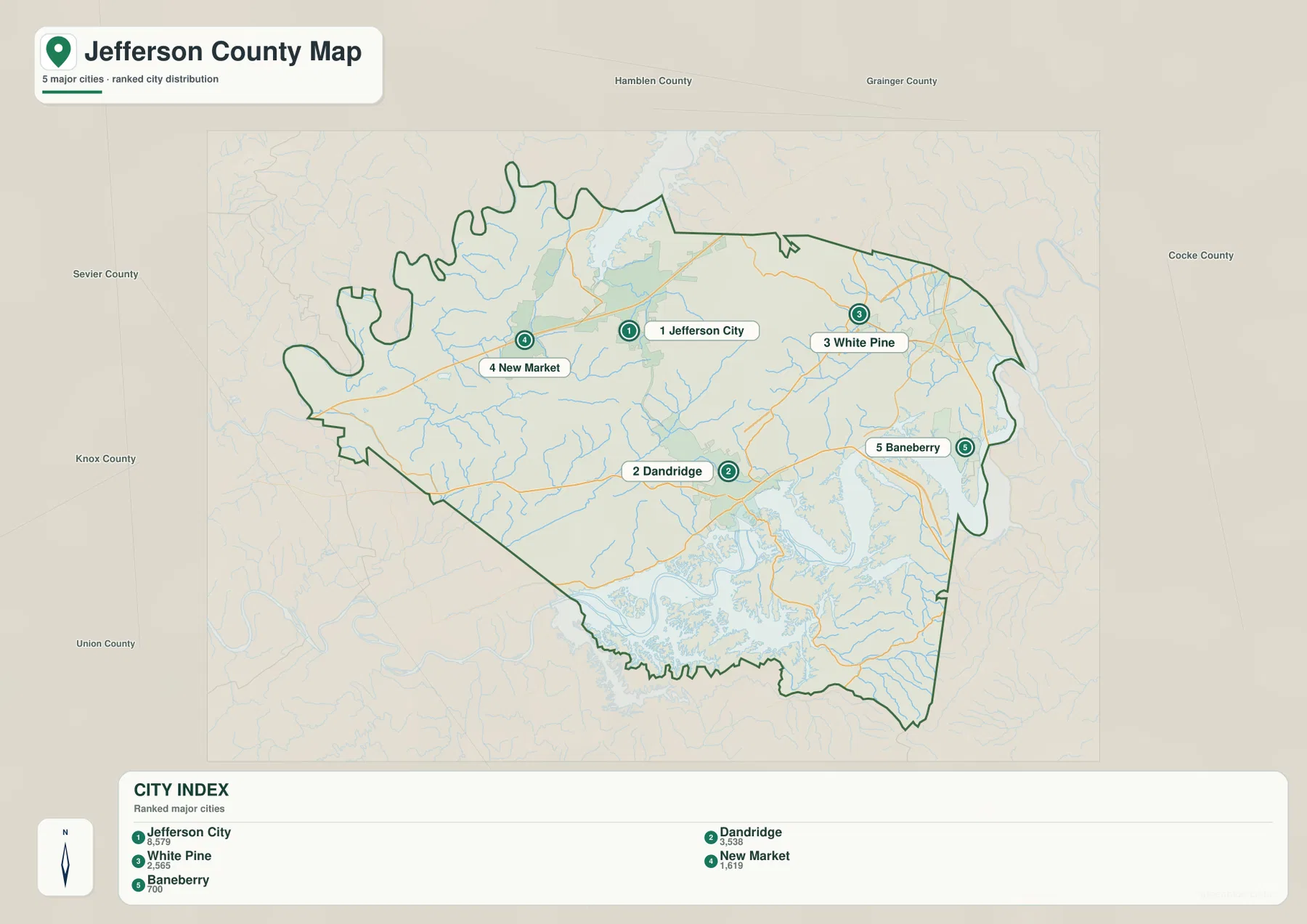
Knox, Sevier, Hamblen, Grainger, and Cocke counties appear around the map as outside references. Jefferson County’s boundary becomes especially irregular along the southern reservoir edge, where long water arms break the shoreline into many projections. That shape matters because a place that looks close across water may require a much longer road approach.
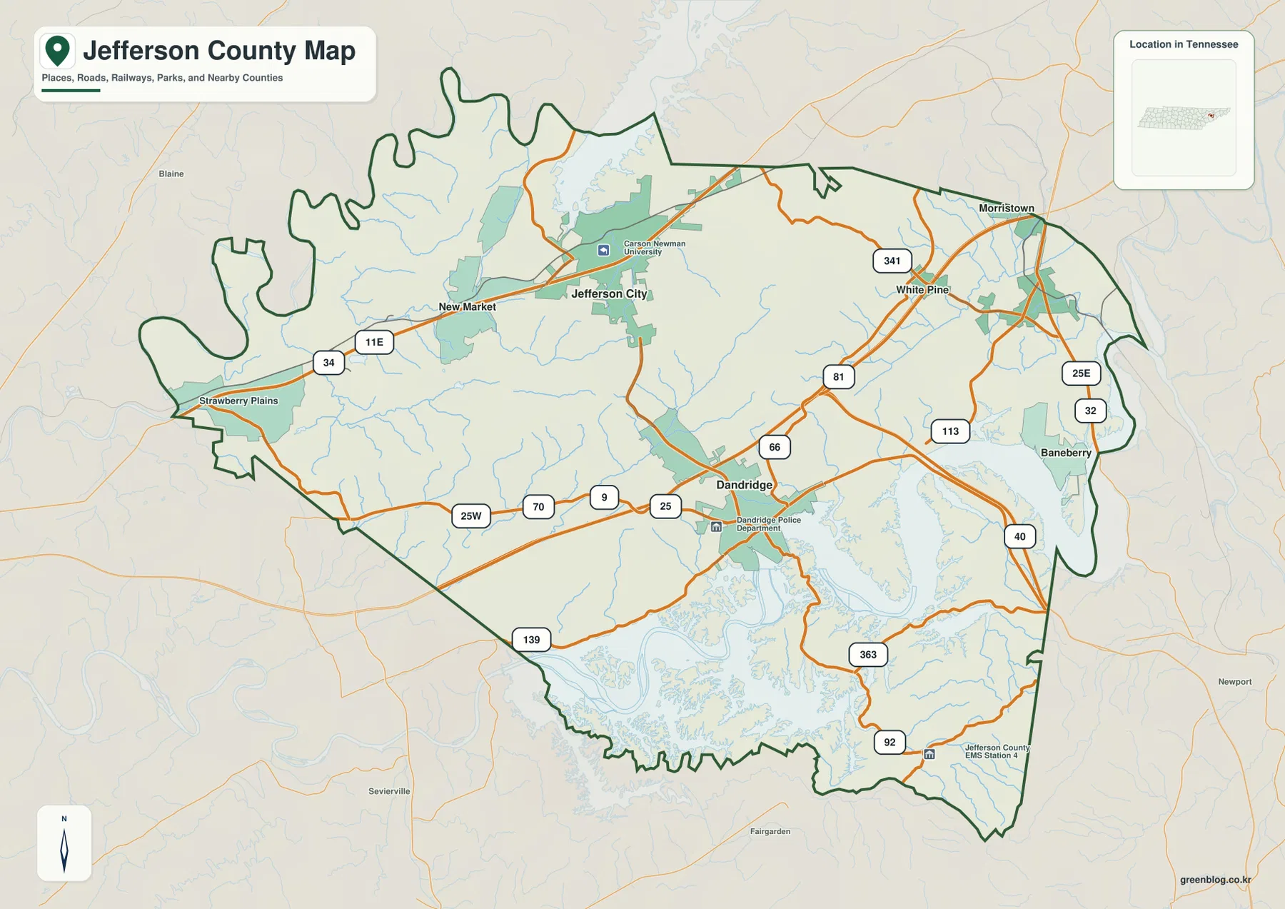
US 11E links New Market and Jefferson City before roads split toward Dandridge and White Pine
US 11E is the clearest west-to-east route through the New Market and Jefferson City side of the base map. Route 34 is also labeled in the west. South of Jefferson City, the road network descends toward Dandridge, where Routes 25W, 70, 9, and 25 are clustered along the southwestern approach.
White Pine is easy to locate with Routes 81 and 341, while Routes 25E and 32 appear near the eastern edge. Route 113 runs northeast from the Dandridge side. Around the eastern and southeastern arms of Douglas Lake, Routes 40, 363, and 92 provide separate references, and Route 139 appears along the southwestern lake-side edge.
A practical reading method is to start with Dandridge or Jefferson City and then add the road serving the destination. US 11E works well for New Market and Jefferson City, Routes 81 and 341 for White Pine, and the 25W–70 corridor for the Dandridge approach from the west. The lake-side routes bend more often because they must work around reservoir arms and rolling ground.
Douglas Lake and French Broad River dominate the south, with Cherokee Lake to the north
Douglas Lake is the largest visible water feature inside the county map. It spreads across the southern and eastern side through many long arms and connects with the French Broad River. Dandridge lies close to this water system, and Baneberry occupies a narrow land area near the eastern shoreline. These reservoir branches strongly influence both the county outline and the shape of nearby roads.
Cherokee Lake appears along the northern side and provides a second large-water reference. Between the two reservoirs, Lost Creek and Beaver Creek cross the western and central interior. Dumplin Creek follows a long southwestern valley toward the Douglas system, while Koonce Creek and Long Creek occupy lower corridors in the central-eastern and northeastern parts of the county.
Muddy Creek is labeled on the southeastern side near the Douglas Lake arms. Smaller water references include Hodges Lake and Cates Pond in the west and Ault Lake farther toward the center. These local features are useful for placing inland areas that are not immediately beside either major reservoir.
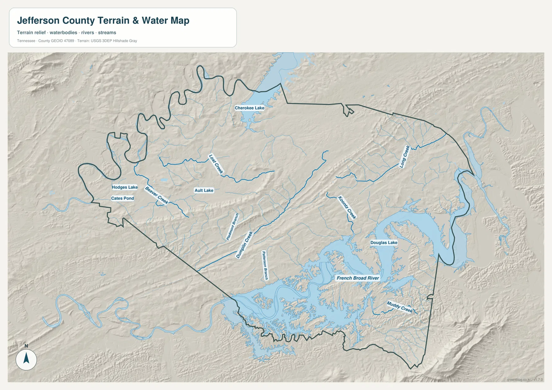
This is a geographic reference layer rather than a live reservoir-conditions product. Water level, marina access, and boating conditions can change, so current field use requires separate agency information. On this page, the layer is used to show how Dandridge and Baneberry relate to Douglas Lake and how Jefferson City and New Market sit among inland creek valleys.
A 256–1,096 m range separates reservoir valleys from very high southeastern terrain
The elevation map shows an actual range of about 256 to 1,096 meters, with a mean near 348 meters. The lowest dark-green terrain follows Douglas Lake, the French Broad River, Cherokee Lake, and the major creek valleys. Long tan and brown ridges cross the central and northeastern interior, and the southeastern corner rises far above the reservoir level.
Jefferson City and New Market sit among lower valleys and moderate rolling ground, but the terrain becomes more strongly ridged toward the east. White Pine lies near a set of parallel higher ridges, with Long Creek occupying one of the lower corridors. This ridge-and-valley pattern helps explain why several roads curve rather than forming a regular grid.
Dandridge is close to the low Douglas Lake shoreline, yet the land rises rapidly toward the southeastern county edge. The darkest brown terrain in that corner is dramatically higher than the reservoir lowlands. That contrast gives Jefferson County one of the clearest low-water-to-high-upland changes among the maps in this series.
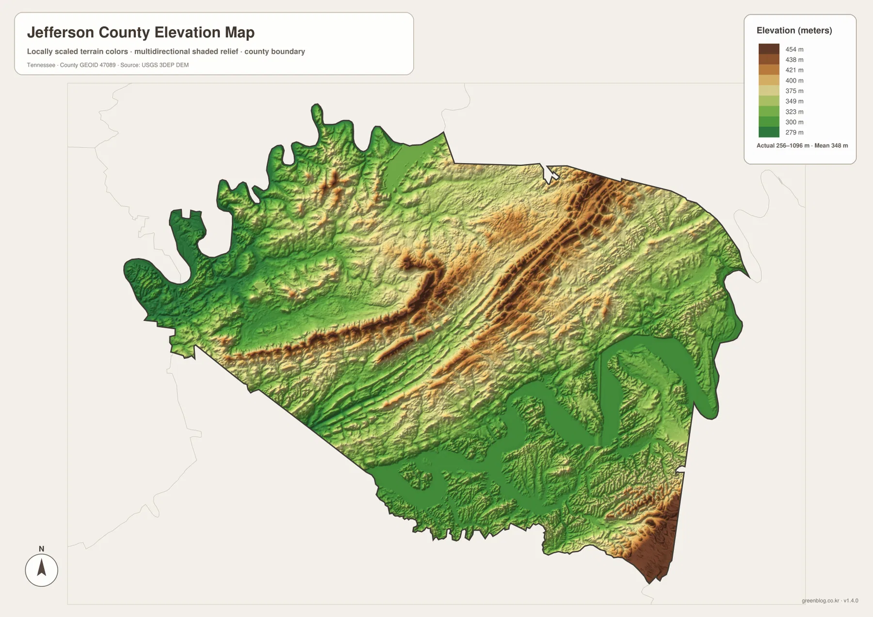
The elevation surface is intended for county-scale comparison rather than a surveyed value at a particular parcel. It is especially useful for seeing the rapid rise away from Douglas Lake and for matching Lost, Dumplin, Koonce, and Long creek valleys with the lower terrain between ridges.
Dandridge and Jefferson City divide the county into four useful map directions
From Dandridge, the south is dominated by Douglas Lake and the French Broad River, the northwest leads toward Jefferson City and New Market, the northeast toward White Pine, and the southeast toward Baneberry and the county’s highest terrain. Using those four directions reduces a complex map to a manageable set of references.
Jefferson City is the largest ranked city, while Dandridge is the county seat. Their different roles become more meaningful when their settings are compared: Jefferson City is tied closely to the US 11E inland corridor, while Dandridge sits beside the Douglas Lake system and roads that must work around reservoir arms.
Use the city map for the five ranked places, the county map for route numbers and local facilities, the water map for the two reservoirs and named creeks, and the elevation map when the contrast between low shorelines and high ridges is the main question.
A3 JPG files for printing, annotation, and closer comparison
The WebP previews are sized for fast browser viewing. The A3 JPG originals provide more room when US 11E, the White Pine road network, or creek labels such as Lost and Dumplin need to be enlarged or marked. Keeping road notes on the base map and water notes on the hydrography image also helps preserve readable labels.
The elevation JPG is particularly useful in color because Douglas Lake remains in the lowest green band while central ridges and the southeastern high ground shift sharply into tan and brown. The city image is the cleanest option when a presentation only needs Jefferson City, Dandridge, White Pine, New Market, and Baneberry.
The ZIP below packages the A3 JPG originals used to compare Dandridge, Jefferson City, Douglas Lake, the road network, named waterways, and Jefferson County relief. They work well for classroom comparison, presentations, route notes, local orientation, and offline reference when the browser images are too small.
Frequently Asked Questions
Why is Dandridge the county seat if Jefferson City is larger?
The city layer ranks Jefferson City at 8,579 and Dandridge at 3,538. Dandridge serves as the county seat, while Jefferson City is the larger ranked city, so the two places provide different administrative and population references.
How large is the elevation difference between Douglas Lake and the southeastern high ground?
The elevation map shows roughly 256–1,096 meters. Douglas Lake and the French Broad River occupy low green terrain, while the southeastern corner reaches much higher brown ground, creating a very large elevation contrast within the county.
Sources and reference data
County history and local reference material are available from the Tennessee State Library and Archives Jefferson County fact sheet. Road placement can be compared with the Tennessee Department of Transportation Jefferson County map, and county boundary data with U.S. Census Bureau TIGER/Line.
For additional hydrography reference, see USGS National Hydrography. Elevation data can be compared with the USGS 3D Elevation Program. The descriptions here follow the cities, roads, Douglas Lake and French Broad River system, named creeks, and elevation differences visible in the supplied Jefferson County maps.
Map File Information
The archive contains the A3 JPG originals for the Jefferson County road, city, water, and elevation maps shown on this page.
- Included Files: County map, city map, water map, elevation map
- File Type: ZIP containing 4 JPG files
Related Maps
- Lake County Tennessee map | Tiptonville and Reelfoot Lake
- Alamo to Gadsden: A Crockett County Tennessee Map
- Altamont, Monteagle, and Plateau Valleys — Grundy County Tennessee Map
Green Map creates custom-edited map images using open geographic data sources such as geoBoundaries, Natural Earth, OpenStreetMap, and government open data. These maps are edited visual materials, not raw data files, and are provided for education, documents, presentations, and graphic reference.