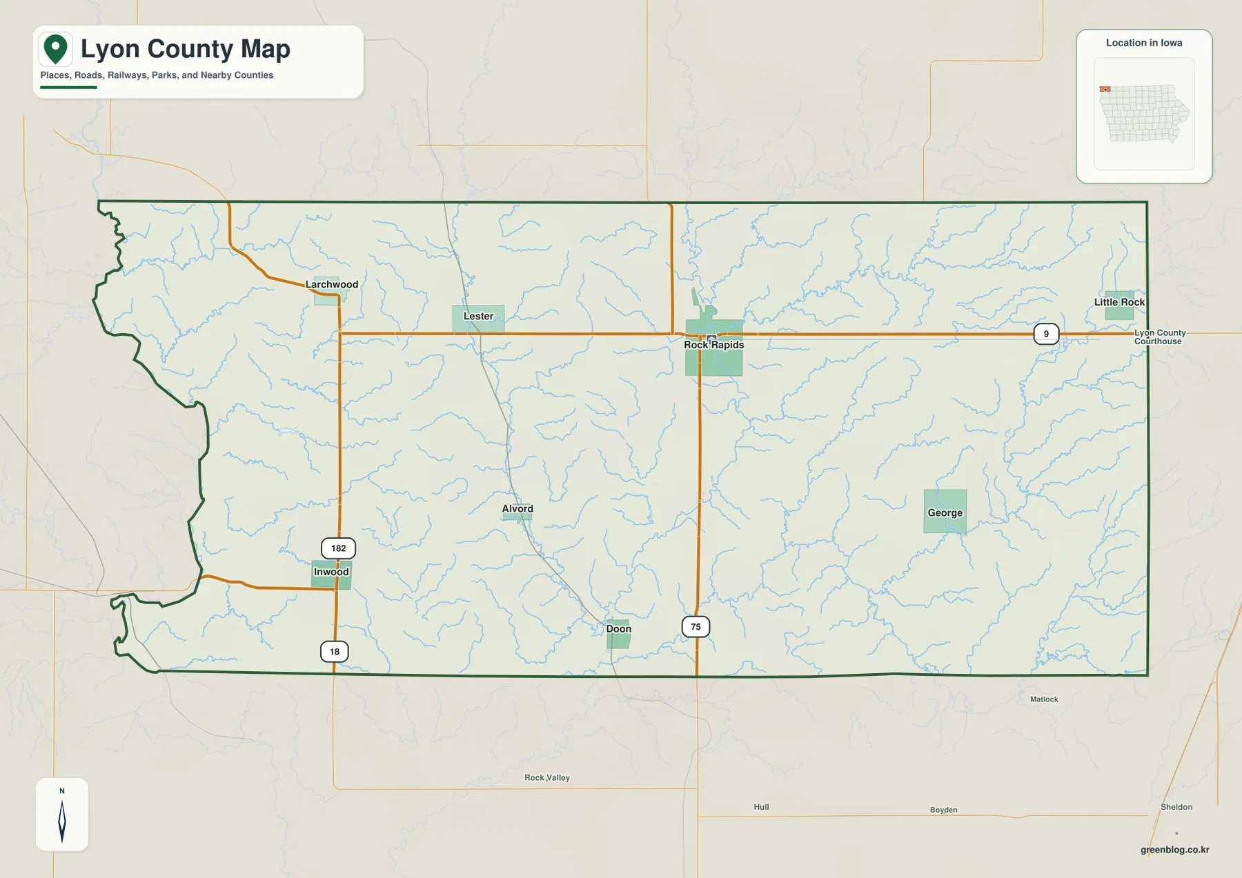
Lyon County occupies the northwestern corner of Iowa, with Rock Rapids serving as the main center and Larchwood, George, Inwood, Doon, and Little Rock spread across the county. U.S. 75 runs north-south through Rock Rapids, while Iowa 9 crosses the central-northern part toward Little Rock. U.S. 18 and Iowa 182 provide additional references near Inwood, and the terrain-and-water map is dominated by Rock River through the center and Little Rock River farther east. This page explains the supplied county, city, terrain-and-water, and elevation maps, and high-resolution JPG versions can be downloaded in a ZIP near the end of the article. High-resolution map files are available for download in the section below.
The easiest way to orient the county is to begin with Rock Rapids and U.S. 75. Larchwood anchors the northwest, Inwood the southwest, George the east-central area, Little Rock the northeast, and Doon the south. The elevation sheet shows higher terrain across much of the west and northwest, while lower green corridors follow the two major river systems through the center and east.
Table of Contents
Rock Rapids and U.S. 75 organize the central road network
Rock Rapids is the strongest first landmark on the general county map. U.S. 75 runs through the city from north to south, while Iowa 9 crosses east-west toward Little Rock. Together, the two roads create a simple framework for locating the central and northern parts of the county.
Larchwood has its own road network in the northwest, while Inwood lies in the southwest near Iowa 182 and U.S. 18. Doon provides a southern reference and George anchors the east-central interior. The map is intended for county-scale orientation rather than live navigation, so current construction and closures should be checked separately.
The rural road grid is comparatively straight, but the waterways cut through the landscape in winding valleys. Several tributaries converge around the Rock River system south and east of Rock Rapids. Around Larchwood, shorter valleys divide the higher western uplands, so the water sheet adds terrain detail that the road map does not show.
Rock Rapids leads a dispersed six-city pattern
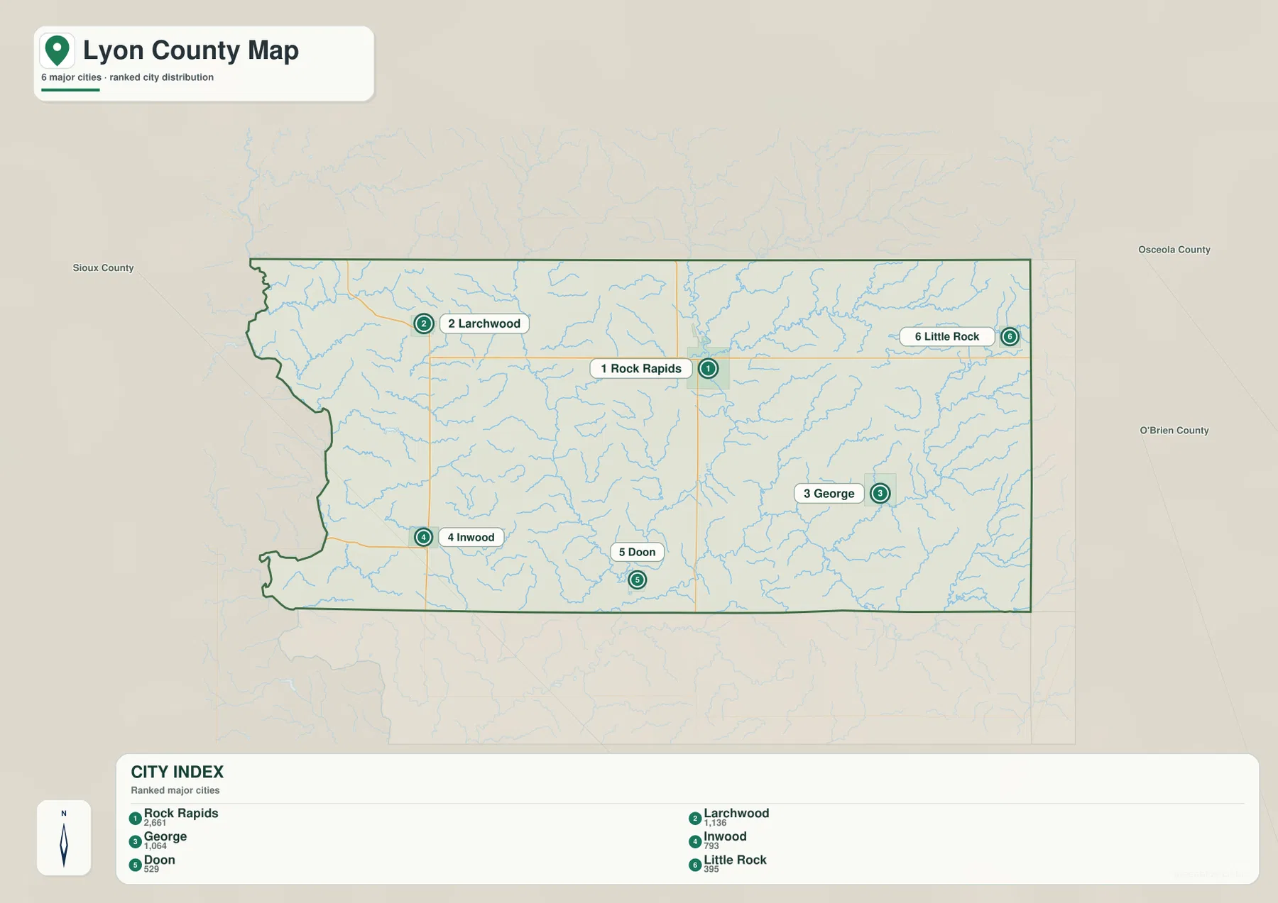
The city map ranks Rock Rapids first with a mapped population of 2,661. Larchwood is second at 1,136 and George third at 1,064. Inwood is fourth at 793, Doon fifth at 529, and Little Rock sixth at 395. The largest community sits near the central-northern part of the county, while the other highlighted towns are spread around the outer sections.
Larchwood provides a northwestern reference and Inwood a southwestern one. George is useful for the east-central area, Doon for the south, and Little Rock for the northeast. Neighboring counties shown around the city map include Sioux, Osceola, and O’Brien, which places Lyon County at the northwestern edge of Iowa.
The city pattern becomes more useful when compared with relief. Larchwood and Inwood sit near higher western uplands, while the Rock River corridor forms a long lower route through the central county. George and Little Rock lie closer to the Little Rock River system and the broader eastern lowlands.
Rock River forms the main north-south valley
Rock River is the dominant waterway on the terrain-and-water map. It enters the north-central part of the county, passes near Rock Rapids, and continues south through a long valley. On the elevation sheet, the same route appears as a dark-green corridor that separates higher terrain on either side.
Mud Creek and Lizard Creek form long valleys west of Rock River, while Tom Creek and Kanaranzi Creek approach from the east. Emery Creek adds another lower corridor across the east-central interior. These tributaries show that the Rock Rapids area is divided into several ridges and valleys rather than one broad flat surface.
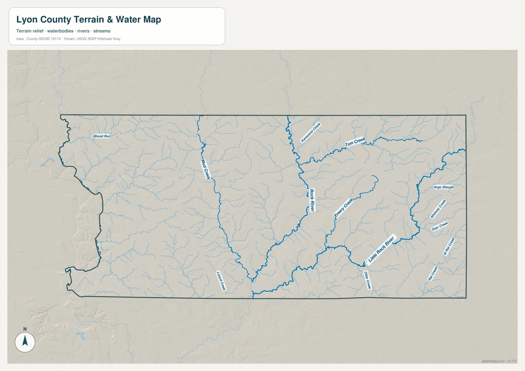
This sheet is intended for geographic reference rather than flood forecasting, current water levels, navigation, parcel boundaries, or legal water limits. Its main value is showing how the major river valleys and tributaries divide the county’s uplands.
Little Rock River and eastern creeks spread across a broader lowland
Little Rock River is the major waterway on the eastern side. It bends through the east-central part of the county and forms a long, comparatively broad valley. Argo Slough is labeled nearby and provides another reference for the lower eastern terrain.
Whitney Creek and Zook Creek appear close to the eastern boundary, while Wolf Run Creek forms another lower route farther southeast. Otter Creek adds a tributary valley south of the Little Rock River corridor. Compared with the central Rock River valley, the eastern side contains a wider network of branching lowlands.
George is a useful reference west of the Little Rock River corridor, and Little Rock helps locate the northeastern drainage and Iowa 9. Doon provides a southern reference between the central and eastern valley systems. Pairing towns with waterways makes the county’s east-west terrain contrast easier to remember.
Elevation ranges from 369 to 482 meters
The supplied elevation map shows an actual county range of about 369 to 482 meters, with a mean elevation of 430 meters. Higher brown terrain covers much of the west and northwest and appears again in parts of the northeast. Lower green corridors follow Rock River and Little Rock River through the center and east, producing a mapped difference of more than 110 meters.
The western high ground is not one smooth plateau. Blood Run and many smaller tributaries cut narrow valleys into the uplands, while Rock River creates a stronger north-south depression through the center. Farther east, Little Rock River and the Whitney Creek system create broader low corridors toward the county boundary.
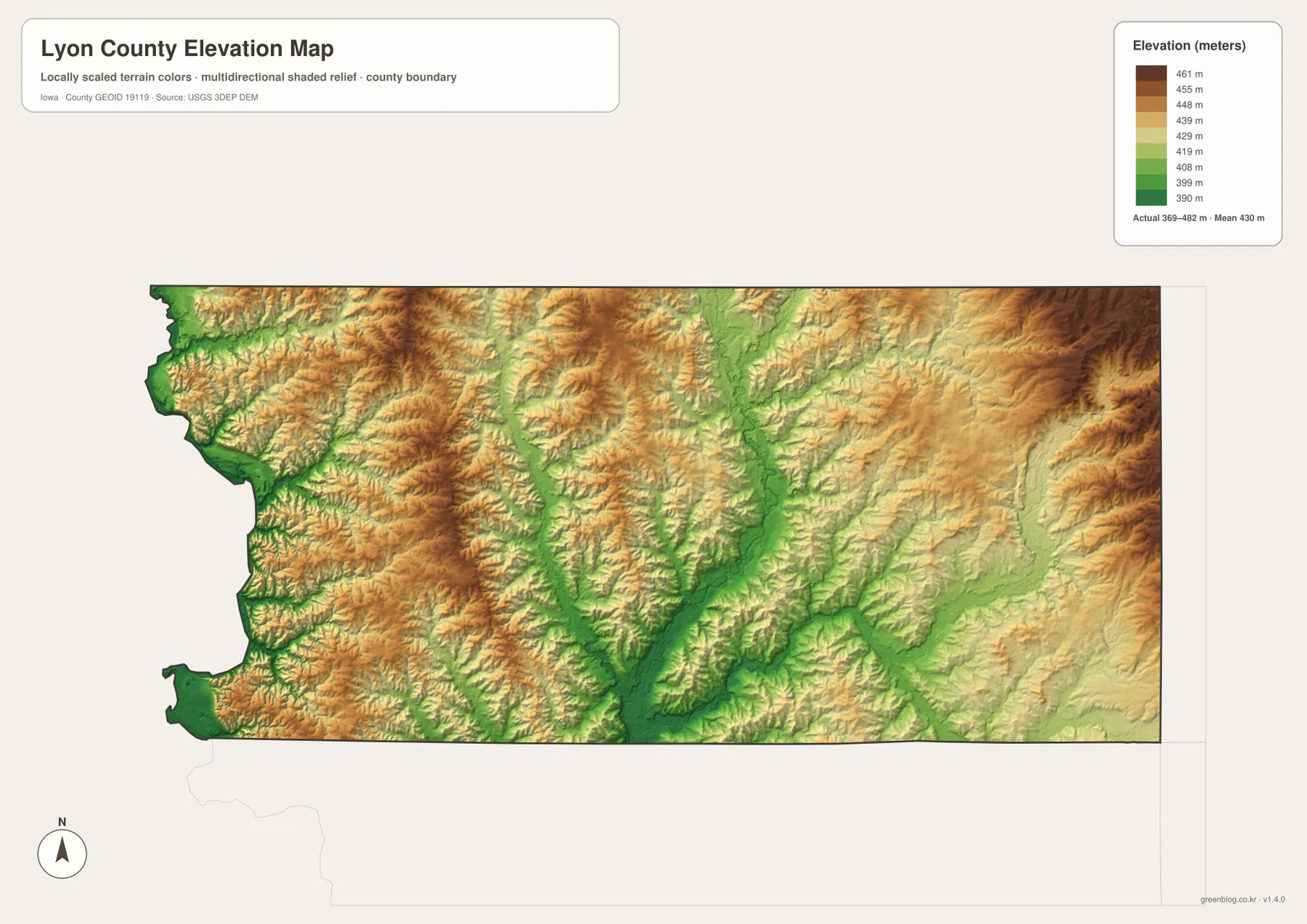
The elevation colors are designed for broad terrain comparison rather than survey-grade measurement. Exact parcel elevation, road grade, engineering design, or construction work requires original elevation data or professional surveying. For general map reading, the key pattern is the contrast between the high western uplands and the lower central and eastern river valleys.
Roads and river valleys reveal the county’s east-west contrast
The general map is easy to orient with U.S. 75 and Iowa 9, while the terrain map is organized by Rock River and Little Rock River. Rock Rapids is the best central reference for comparing the road and drainage layers. Larchwood and Inwood help locate the higher western country.
George and Little Rock work well for the eastern river system, and Doon provides a useful southern reference between the major valley corridors. Looking at the same places across the county, city, water, and elevation maps makes Lyon County’s upland-and-valley structure much easier to understand.
Choose the Lyon County map that fits the task
Use the general county map when you need towns and numbered roads in one view. It is the quickest way to compare Rock Rapids, Larchwood, George, Inwood, Doon, and Little Rock with U.S. 75, Iowa 9, U.S. 18, and Iowa 182. The city map is better when the goal is to compare the six highlighted communities and the population ranking shown on the supplied graphic.
The terrain-and-water map is best for Rock River, Little Rock River, Mud Creek, Lizard Creek, Kanaranzi Creek, Tom Creek, Emery Creek, Whitney Creek, Zook Creek, Wolf Run Creek, and other tributaries. The elevation map adds the 369–482 m range and makes the higher western uplands and lower central-eastern valleys immediately visible.
The WebP images in the article are optimized for quick browser viewing. For printing, classroom use, presentations, or closer comparison, the ZIP below contains the county, major-city, terrain-and-water, and elevation maps as high-resolution JPG files. They are general-reference graphics and do not replace legal boundary records, current transportation data, flood information, or precise survey measurements.
Frequently Asked Questions
Which map is best for locating Rock Rapids and Larchwood?
The general county map is the best starting point. Rock Rapids is near the central-northern part of the county where U.S. 75 and Iowa 9 meet, while Larchwood lies farther northwest. George, Inwood, Doon, and Little Rock are also labeled on the same sheet.
What are the main rivers and creeks shown in Lyon County?
Rock River forms the main central valley, while Little Rock River crosses the eastern side. Mud Creek, Lizard Creek, Kanaranzi Creek, Tom Creek, Emery Creek, Whitney Creek, Zook Creek, and other tributaries divide the surrounding uplands.
What does the 369–482 m elevation range show?
The elevation map shows higher terrain across much of the west and northwest and lower valleys along Rock River and Little Rock River. The mapped mean elevation is 430 meters. Precise site elevations require original elevation data or professional survey information.
Map File Information
The ZIP contains four high-resolution JPG maps for Lyon County, Iowa: county, major cities, terrain and water, and elevation.
- Included Files: Use only the versions confirmed in the article and supplied images
- File Type: Use the confirmed download contents
- Intended Use: Printing, education, presentations, and map-based projects
Related Maps
Sources and reference data
The links below provide authoritative U.S. government source data for county boundaries, hydrography, and elevation represented in the supplied map set.
These maps are intended for general geographic reference, learning, printing, and visual comparison. Legal boundaries, ownership, current road conditions, flood risk, water levels, and precise elevations should be checked against the responsible agency’s current records.
Green Map creates custom-edited map images using open geographic data sources such as geoBoundaries, Natural Earth, OpenStreetMap, and government open data.
These maps are edited visual materials, not raw data files, and are provided for education, documents, presentations, and graphic reference.