You can download four high-resolution A3 JPG maps of Leon County, Texas, in one ZIP directly from this page. The set includes a general county map, a ranked city map, a terrain-and-water map, and an elevation map. Together they show Buffalo, Jewett, Centerville, Normangee, Oakwood, and Leona, roads marked 164, 79, 7, 75, and 45, the Navasota and Trinity river systems, several named lakes, and an actual elevation range of about 41 to 187 meters.
Buffalo and Centerville are useful orientation points because they sit in different parts of the county. Buffalo is near the northwestern side and has Route 164 labeled beside it, while Centerville is farther south near the middle. Jewett lies between those areas, Oakwood is northeast of Buffalo, and Leona and Normangee occupy the southern half. Once those settlements are located, the water map makes the east-west contrast especially clear: the Navasota River is on the western side, while the Trinity River follows the eastern edge.
Table of Contents
Buffalo and Centerville make the road map easier to orient
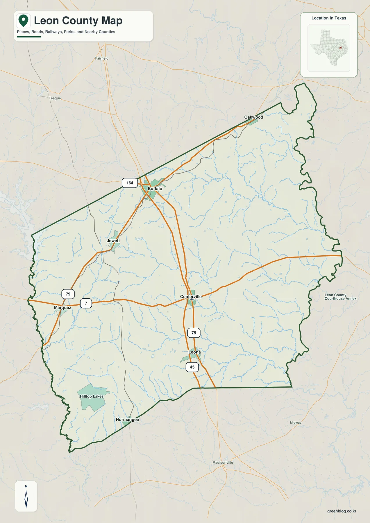
Buffalo is one of the strongest labels on the general county map. It sits toward the northwest, where several roads meet and the number 164 is marked nearby. Jewett appears south of Buffalo along the same broad part of the county. Centerville is farther south and closer to the middle, giving the map a useful sequence of northern and central reference points.
West of Centerville, Marquez is labeled near roads marked 79 and 7. South of Centerville, the map shows 75 and then 45 along the same general north-south corridor toward Leona. Oakwood sits well to the northeast near the upper county boundary, while Normangee is near the southwestern end. Those places are spread widely enough that the county cannot be understood as a single compact town cluster.
Hilltop Lakes is also labeled in the southwest, and a Leon County Courthouse Annex label appears just outside the eastern side of the boundary. Thin blue waterways cross the entire map, but the road and settlement labels compete for attention. The general map is best for placing communities and numbered routes; the water map later on the page is clearer when the names of streams and lakes matter.
The city index spreads six ranked communities across the county
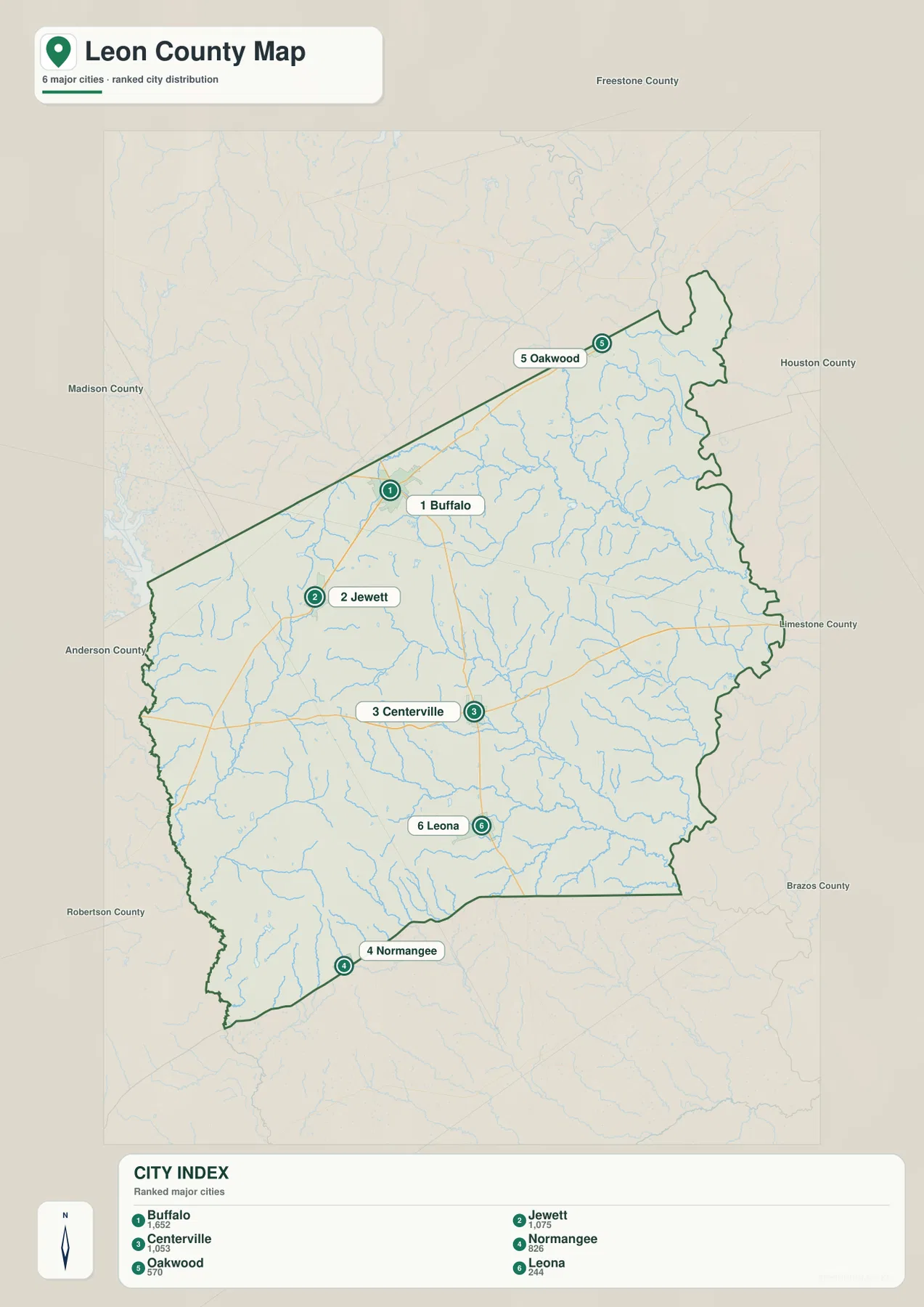
The ranked city map identifies six major communities. Buffalo is number 1, Jewett number 2, Centerville number 3, Normangee number 4, Oakwood number 5, and Leona number 6. The ranking is useful as an index for the map, but the locations are just as important because the six points are distributed from the northeast to the southwest.
Buffalo and Jewett are relatively close in the northwestern half, while Oakwood is separated from them toward the northeast. Centerville lies farther south near the middle, Leona is below it, and Normangee is close to the southwestern tip. The pattern is not a single straight chain of towns. It is a dispersed set of communities linked by roads that cross a heavily drained landscape.
Freestone, Houston, Limestone, Brazos, Robertson, Anderson, and Madison counties are labeled around the outside of the city map as regional references. This view is most useful when only the major city distribution needs to be shown. For route numbers, Marquez, Hilltop Lakes, and other details, the general map provides the fuller picture.
Navasota River and Trinity River frame a dense creek network
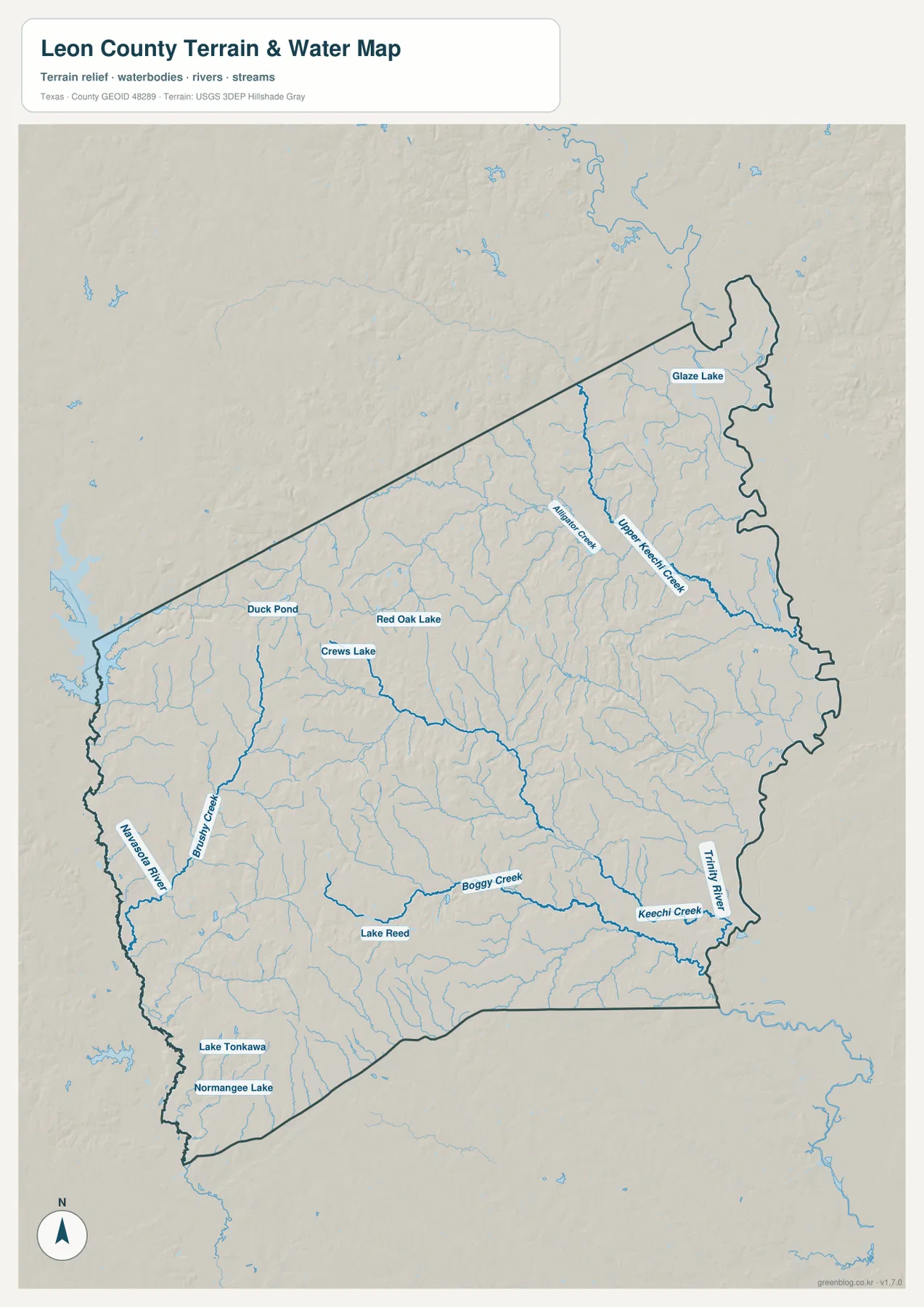
The terrain-and-water map makes the county’s drainage much easier to read. Navasota River is labeled along the western side, while Trinity River runs along the eastern edge. Between those two larger rivers, long creeks cross the interior from different directions. Brushy Creek is prominent in the western half, and Boggy Creek runs through the south-central part of the county toward the east.
Keechi Creek is labeled in the southeast close to the Trinity River. In the northeastern half, Upper Keechi Creek and Alligator Creek form another important pair of named waterways. Their courses extend southward through the eastern interior before joining the broader drainage toward the county’s eastern side. These names provide much better location references than the thin unlabeled blue lines visible on the general map.
Several named lakes and ponds add smaller landmarks. Glaze Lake is in the northeast, while Duck Pond and Red Oak Lake are farther west. Crews Lake is labeled in the western interior, Lake Reed appears in the south-central area, and Lake Tonkawa and Normangee Lake are near the southwest. This map is a geographic water reference, not a flood-hazard, parcel-boundary, legal-water-boundary, or navigation product.
Higher western hills descend toward the Trinity River side
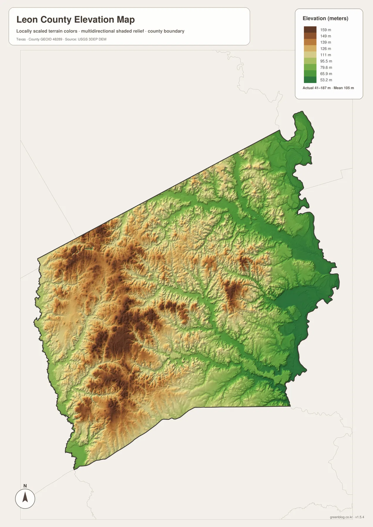
The elevation map reports an actual range of about 41 to 187 meters and a mean elevation of about 105 meters. Browns and tans are concentrated across the west and southwest, where the higher ground is most extensive. Green colors spread more widely toward the center and east, and the lowest terrain becomes especially prominent near the eastern boundary.
The water map explains much of that relief. Lower corridors follow Boggy Creek, Keechi Creek, and other tributaries, while the broad eastern side drops toward the Trinity River. The western uplands are not a single flat surface; shaded relief shows repeated ridges and valleys cut by smaller streams. That texture is one of the clearest differences between the west and the greener eastern lowlands.
The displayed difference between the minimum and maximum is about 146 meters. That is enough to produce visible relief across the county even though the map does not depict a high mountain region. The elevation image is best used to compare relative height and river valleys; it should not be treated as survey-grade or engineering-grade elevation measurement.
Matching the same locations across road, water, and elevation views
The Buffalo-Jewett area provides a useful comparison. The general map shows the northern road network and Route 164 near Buffalo. The water map adds Red Oak Lake, Crews Lake, and nearby tributaries, while the elevation map shows that this western side contains more higher-colored terrain than the eastern edge. Looking at all three views makes the local setting more concrete than a road-only map.
Centerville offers a second comparison. From the general map, it is easy to see its position between Marquez, Leona, and the eastern half of the county. The water map then reveals Boggy Creek and Keechi Creek farther east, and the elevation map shows lower green valleys continuing toward the Trinity River. The same county outline makes those transitions easy to follow without reorienting the page.
Use the city map for the six ranked communities, the general map for roads and additional place names, the water map for rivers, creeks, lakes, and ponds, and the elevation map for the higher-west/lower-east contrast. Some smaller labels are easier to inspect in the high-resolution files than in the web previews, especially when the map is being printed or enlarged.
Frequently Asked Questions
Which communities are ranked on the Leon County city map?
The map ranks Buffalo first, Jewett second, Centerville third, Normangee fourth, Oakwood fifth, and Leona sixth. Their positions are widely distributed, from Oakwood in the northeast to Normangee in the southwest.
Which rivers and creeks are easiest to identify?
Navasota River on the west and Trinity River on the east are the largest labeled references. Brushy Creek, Boggy Creek, Keechi Creek, Upper Keechi Creek, and Alligator Creek are also clearly named on the supplied water map.
What elevation range is shown for Leon County?
The supplied elevation map reports an actual range of about 41 to 187 meters and a mean of about 105 meters. Higher ground is more common in the west, while lower terrain becomes widespread toward the Trinity River and eastern creek valleys.
Sources and Reference Data
- U.S. Census Bureau TIGER/Line Shapefiles — official county-boundary and road geometry for geographic reference.
- USGS National Hydrography — official resources for rivers, creeks, lakes, and other water features.
- USGS 3D Elevation Program — official elevation resources used for terrain information.
- USGS The National Map Viewer — an official viewer for comparing multiple geographic layers.
Map File Information
Download four high-resolution A3 JPG maps of Leon County, Texas, in one ZIP file.
- Included Files: county map, ranked city map, terrain and water map, elevation map
- File Type: JPG
Related Maps
- Anderson County Texas map
- Robertson County Texas map
- Washington County Texas map
- Navarro County Texas map
- Angelina County Texas map
Green Map creates custom-edited map images using open geographic data sources such as geoBoundaries, Natural Earth, OpenStreetMap, and government open data.
These maps are edited visual materials, not raw data files, and are provided for education, documents, presentations, and graphic reference.