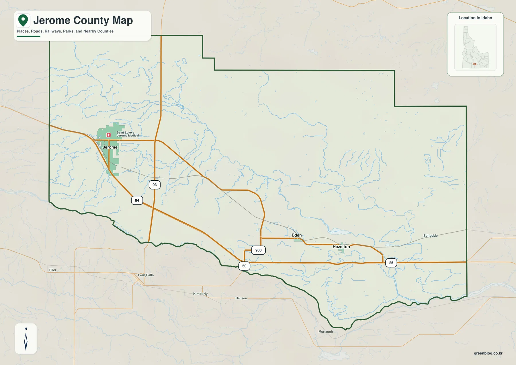
Jerome County lies in south-central Idaho, north of the Snake River, with the city of Jerome near the western side of the county and Eden and Hazelton farther southeast. The general county map makes the road pattern easy to recognize: Interstate 84 crosses the southern half, U.S. 93 runs north-south near Jerome, and Idaho 25 continues east through the Hazelton area. This page explains those roads, the settlement pattern, the county’s canals and reservoirs, and the broad rise in elevation toward the east. High-resolution JPG versions of the same maps are also available together in a downloadable ZIP.
The county is compact compared with many large western Idaho counties, but the maps still show clear differences from one side to the other. Jerome sits in a busier western road network, while Eden and Hazelton form a smaller southeastern cluster. North of those communities, major place labels become sparse and the map opens into a broad rural interior. Along the southern edge, the Snake River forms a strong geographic reference, and the water map shows that the interior depends on a web of named canals, drains, and small reservoirs rather than one large river crossing the middle of the county.
The WebP images in the article are sized for quick viewing on a webpage. The download package contains larger 3638×2572 JPG files for closer reading, printing, or presentation use. There is one county-and-roads map, one city-connections map, one terrain-and-water map, and one elevation map. Looking at them separately keeps road labels, water features, and elevation colors from competing for attention on a single crowded image.
Table of Contents
Jerome anchors the western side of the county’s road network
On the county map, Jerome is the most prominent place name and sits close to the western side of the county. U.S. 93 passes north-south just east of the city and continues toward the Snake River and Twin Falls area. Interstate 84 enters from the west, passes the Jerome area, and runs southeast across the county. Farther east, Idaho 25 is labeled through the Hazelton side of the map. Together, these routes provide a simple framework for understanding where the county’s main named communities sit.
The southern half carries most of the obvious road activity. Jerome has several connecting roads around it, while Eden and Hazelton lie along the southeastern corridor where the highway pattern becomes more concentrated again. The northern and northeastern interior has far fewer major road labels. That contrast is useful when reading the map: instead of treating the county as an evenly settled rectangle, it is easier to see a busier southern belt and a quieter rural interior extending toward the stepped northern boundary.
Nearby places outside the boundary give additional orientation. Twin Falls, Filer, Kimberly, Hansen, and Murtaugh appear south of the county on the general map. The city-connections map labels Lincoln County to the north, Gooding County and Twin Falls County to the west, and Minidoka and Cassia counties to the east. These outside labels are context, not part of Jerome County itself. For legal boundary work, parcel research, or address decisions, use current official GIS or Census boundary data rather than a general reference map.
The official Jerome County website lists GIS Maps among its public resources. Those official systems are the better choice when a task depends on current administrative detail. The maps on this page are designed for geographic orientation and image download: they help a reader see where cities, roads, water features, and higher terrain sit in relation to one another without turning the page into a parcel or legal-boundary application.
Eden and Hazelton form a southeastern settlement pair
The city-connections map removes much of the background detail and focuses on three named communities. Jerome is the hub on the west, Eden is southeast of Jerome, and Hazelton lies farther east and slightly south of Eden. The map reports a direct distance of about 17 miles from Jerome to Eden and about 21 miles from Jerome to Hazelton. These are straight-line distances between the places, not mileage measured along a driving route.
That distinction matters because actual travel follows the road system rather than a direct line. Interchanges, local roads, and route choices can make a driving trip longer than the number printed on the map. The distance values are best used to compare relative spacing. They show that Eden and Hazelton sit in the same general southeastern part of the county, while Jerome is separated to the west by a broad stretch of agricultural and rural land.
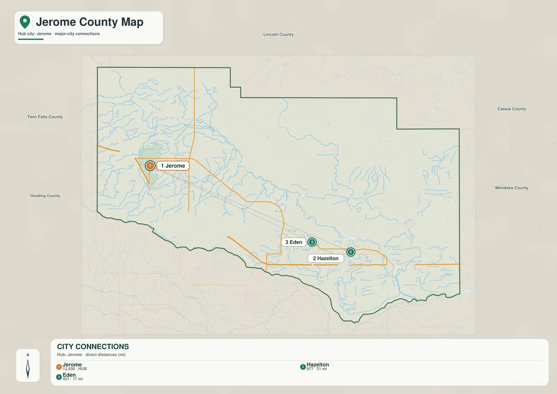
Other numbers printed beside the city names should not be treated here as current population estimates. The purpose of this image is location and spacing, not demographic reporting. If current population, housing, or land-area statistics are needed, the U.S. Census Bureau QuickFacts page for Jerome County provides dated official figures. Keeping those uses separate prevents a simple connection map from being mistaken for a current statistical table.
The water map is a network of canals, drains, reservoirs, and the Snake River
The Snake River is the largest named water feature on the terrain-and-water map. It follows the county’s southern edge and provides a clear reference for the low southern margin. North of the river, however, the map is not dominated by a single natural stream. Instead, blue lines spread across the interior as a network of canals, drains, and smaller water features. This makes the water map especially useful for understanding the rural landscape between Jerome and the eastern side of the county.
Several labels stand out. Milner Gooding Canal runs through the central-eastern part of the county, while Wilson Lake Reservoir and Goose Lake appear in the south-central to southeastern area. Other named canals and drains branch across the western, central, and eastern sections. Near the southern edge, labels such as A Canal and C Canal appear close to the Snake River. The dense collection of blue lines reflects both natural water and managed irrigation or drainage features, so not every line should be read as a natural creek.
This distinction is important for practical use. The map is good for identifying names and comparing locations, but it does not show current flow, water depth, flood hazard, water rights, or whether a particular canal is active at a given time. Those questions require current information from the responsible agencies. Here, the value of the map is visual: it shows how the Snake River forms the southern reference while a much finer water network spreads over the plain to the north.
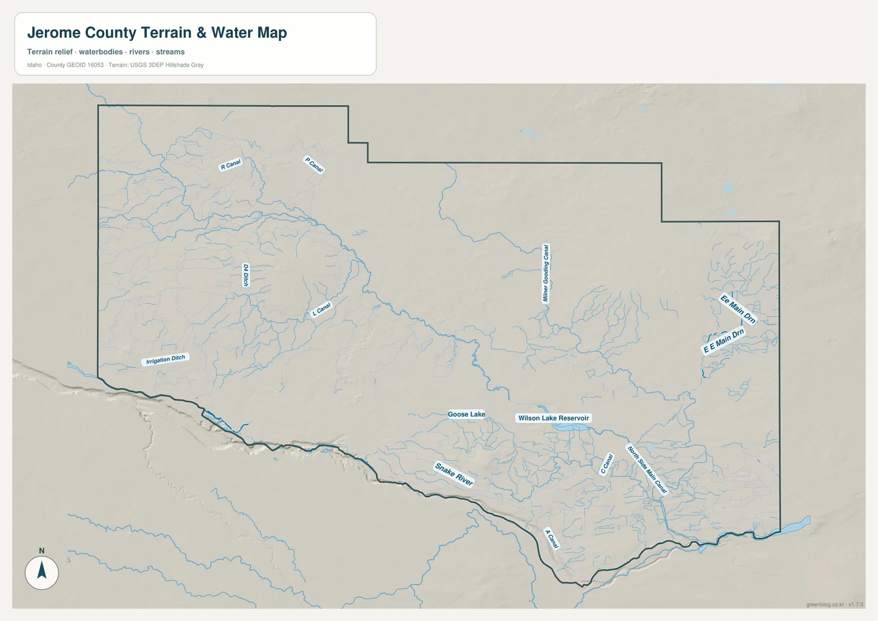
For a more authoritative hydrographic reference, the USGS National Hydrography program is a useful companion source. It is particularly helpful when a small channel name or water feature needs to be checked against current official data. The image on this page should remain a geographic reference rather than a flood, navigation, engineering, or water-rights product.
Elevation rises from the western lowlands toward higher ground in the east
The elevation map gives Jerome County a very different appearance from the road map. Its summary lists an actual elevation range of about 909 to 1,445 meters, with a mean of 1,216 meters. Green shades dominate the western and southwestern side, indicating the lower part of the county. Yellow, orange, and brown become more common toward the east and northeast, where the land rises. The broad west-to-east increase is the first pattern to notice.
The rise is not perfectly smooth. Several isolated higher features appear within the central and southeastern parts of the county, and a larger area of higher terrain stands out in the northeast. Along the western portion of the southern boundary, the Snake River side remains comparatively low. Looking back at the water map helps connect these two views: the largest river occupies the lower southern margin, while much of the interior climbs gradually away from it toward the east.
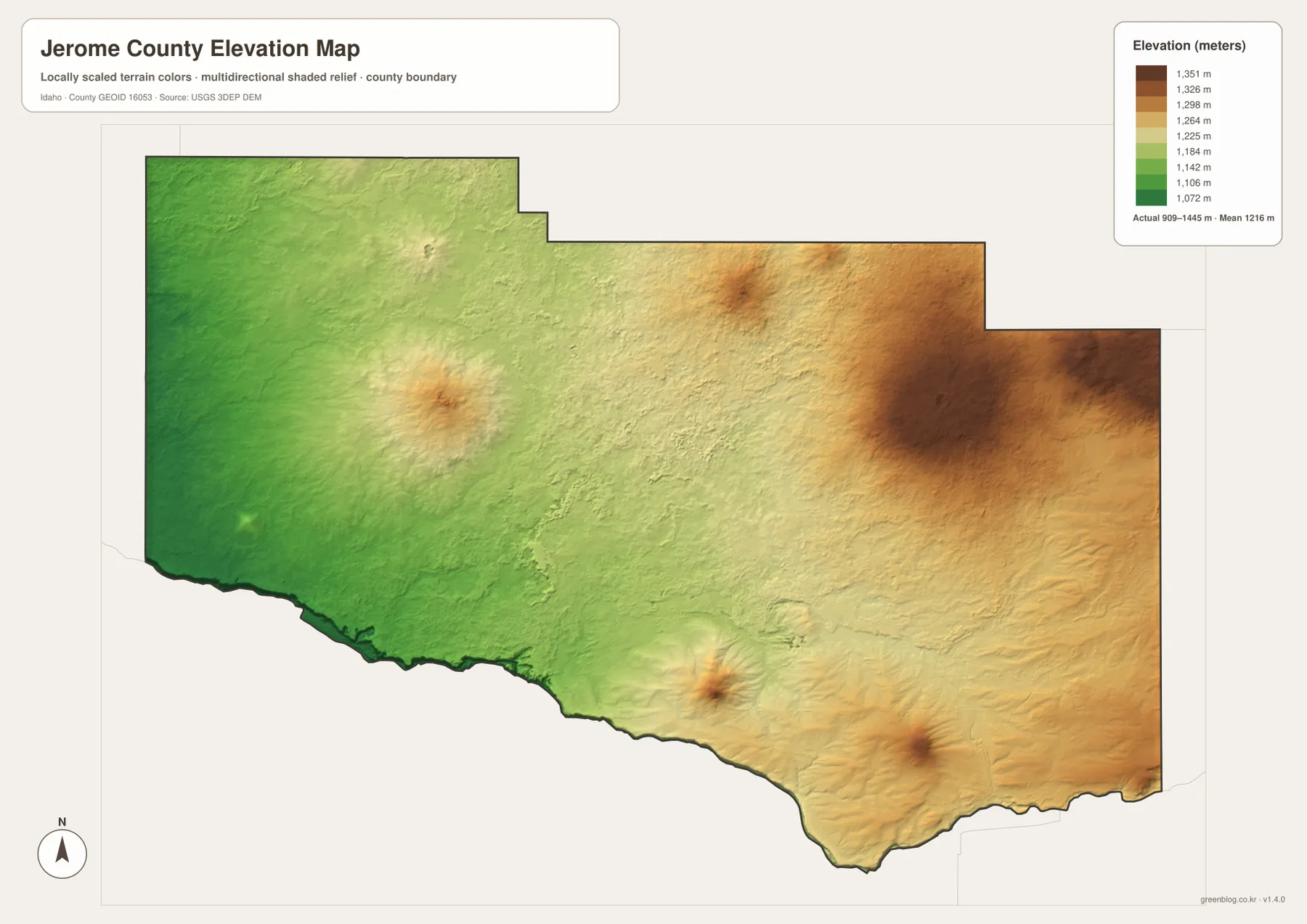
The color surface is intended for county-wide comparison, not survey work. A reader can see which broad areas are lower or higher, but the image should not be used to determine the precise elevation of a parcel, road, building site, or engineering point. For exact terrain measurements, the USGS 3D Elevation Program or other current professional data is the appropriate source.
Choose the map by the detail you need, not by trying to read everything at once
For a first look at Jerome County, start with the general map. It establishes the boundary, the location of Jerome, the southeastern Eden-Hazelton cluster, and the major roads that tie the southern part of the county together. The city-connections map is better when the question is simply how the three named communities are positioned and how far Eden and Hazelton are from Jerome in a direct line.
The terrain-and-water map becomes more useful once the focus shifts away from cities. It identifies the Snake River, Milner Gooding Canal, Wilson Lake Reservoir, Goose Lake, and the many smaller canals and drains across the plain. The elevation map answers a different question by stripping away most labels and emphasizing relief: lower ground in the west and southwest, higher ground toward the east and northeast, plus several isolated elevated features.
If the map will be printed or enlarged, the downloadable JPG files are preferable to the WebP previews embedded in the page. Each JPG is 3638×2572 pixels, which gives road numbers, water labels, and elevation colors more room to remain legible. The ZIP contains only the four maps described on this page; it is not a parcel archive, flood map, or navigation package.
Frequently Asked Questions
Are the 17 miles to Eden and 21 miles to Hazelton driving distances?
No. The city-connections map uses straight-line distance from Jerome. Roads do not follow a perfect direct line, so actual driving mileage can be different. Use the printed distances to compare the relative spacing and direction of the communities, then check a current road or navigation service when planning a trip.
Which map is best for the Snake River and Jerome County’s canals?
The terrain-and-water map is the most useful choice. It labels the Snake River, Milner Gooding Canal, Wilson Lake Reservoir, Goose Lake, and many smaller canals and drains that are not emphasized on the city map. It is a location reference, however, not a flood-hazard, water-rights, depth, or navigation map.
What does the elevation map show most clearly?
It shows the broad rise from lower western and southwestern terrain toward higher ground in the east and northeast. The map reports an actual range of about 909–1,445 meters and a mean of 1,216 meters. Several isolated higher features also stand out in the interior. Use it for regional comparison rather than precise survey-grade elevation.
Map File Information
Download the high-resolution Jerome County JPG maps together when you need larger images than the WebP previews shown in the article.
- Included Files: county map, city-connections map, terrain-and-water map, elevation map
- Printable Size: 3638×2572 pixels for each JPG
- File Type: ZIP containing 4 JPG files
Related Maps
Sources and references
Official county services and GIS resources are available from the Jerome County official website. Current population, housing, and land-area statistics can be checked through U.S. Census Bureau QuickFacts: Jerome County, Idaho.
For supporting geographic data, use U.S. Census Bureau TIGER/Line Shapefiles for boundaries, USGS National Hydrography for water features, and the USGS 3D Elevation Program for elevation data.
Green Map creates custom-edited map images using open geographic data sources such as geoBoundaries, Natural Earth, OpenStreetMap, and government open data.
These maps are edited visual materials, not raw data files, and are provided for education, documents, presentations, and graphic reference.