The Chester County South Carolina Map set on this page can be viewed online and downloaded as three matching high-resolution A3 JPG files in one ZIP archive. The maps help locate the county, show how Chester connects with Richburg, Fort Lawn, Great Falls, and Lowrys, and place the Catawba River and interior creeks in the same landscape. The general county map emphasizes the boundary and numbered roads, the city view makes the five mapped communities easy to compare, and the terrain-and-water view brings the river system and broad relief into focus.
These files are best treated as county-scale reference maps. They are not turn-by-turn navigation products, parcel maps, survey drawings, or flood-zone maps. Their strength is the way they separate different questions without losing the common geography of Chester County: Chester remains the central reference, eastern communities move progressively closer to the Catawba side, and the water map shows why the county cannot be understood only from its roads. The downloadable JPG files preserve the same subjects as the previews, so you can switch from quick on-screen reading to a larger printable version without changing map content.
Table of Contents
Chester County in the South Carolina Piedmont
Chester County lies in South Carolina’s Piedmont, with Chester serving as the county seat. The U.S. Census Bureau reports about 580.9 square miles of land and a 2020 population of 32,294. The South Carolina Association of Counties lists the county as formed in 1785 and identifies Fort Lawn, Great Falls, Lowrys, and Richburg among its other municipalities. Those facts provide useful scale, but the maps make the county easier to understand by showing how those names are distributed across a broad east-west outline rather than clustered around the county seat.
The four adjacent counties are York to the north, Lancaster to the east, Fairfield to the south, and Union to the west. Chester sits a little west of the center of the county outline. Lowrys is north of Chester, Richburg and Fort Lawn are farther east, and Great Falls drops toward the southeastern corner. That pattern matters because a reader who uses Chester as the only reference point may underestimate how far the county stretches toward the Catawba River side.
| State | South Carolina |
|---|---|
| County | Chester County |
| County seat | Chester |
| Mapped communities | Chester, Great Falls, Fort Lawn, Richburg, Lowrys |
| Adjacent counties | York, Lancaster, Fairfield, Union |
| 2020 population | 32,294 |
| Land area | about 580.9 sq mi |
| Major water references | Catawba River, Fishing Creek system, Sandy River system |
Reading the boundary first also helps separate inside references from surrounding labels. McConnells, Catawba, Lockhart, and Carlisle appear in the wider background of the county map, but the darker Chester County outline makes clear that nearby names do not automatically belong inside the county. This is especially useful when comparing adjacent county pages, where many of the same regional roads and waterways continue across boundaries.
Roads spread from Chester toward Richburg and the eastern side
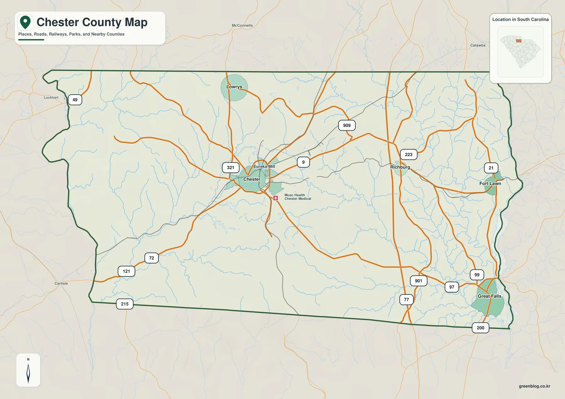
Chester is the strongest road reference on the general map because several routes meet in and around the city. US 321 runs through the Chester–Lowrys part of the county and gives the central area a clear north-south reference. SC 9 heads east from Chester toward Richburg. On the southwestern side, route labels 72, 121, and 215 help define a less densely labeled part of the county. Together, these roads make it possible to orient the western half without relying on a long list of smaller local streets.
The map changes character as it moves east. Richburg is close to the I-77 corridor and is also shown near routes 223 and 909. Fort Lawn sits farther toward the county’s eastern edge near Route 21. In the southeastern part, the Great Falls area is surrounded by route labels including 97, 99, 200, and 901. These are useful position markers rather than a replacement for live driving directions. What they show well is that the eastern side contains several distinct road centers rather than one single cluster.
Smaller references make the Chester area more recognizable. Eureka Mill appears immediately east of Chester, while MUSC Health Chester Medical Center is marked to the southeast. Those details help tie the county-scale outline to places a local reader may already know. At the same time, the map remains deliberately broader than a municipal street map; the colored settlement areas and labels should not be read as precise legal city limits.
For a practical reading sequence, start with Chester and find US 321 and SC 9. Then move east to Richburg and the I-77 corridor before locating Fort Lawn and Great Falls. This keeps the county’s main directions clear even when the map is reduced on a printed page. If you begin with isolated road numbers instead, it is easier to lose the relationship between the central county seat and the communities near the Catawba side.
The five mapped communities occupy different parts of the county
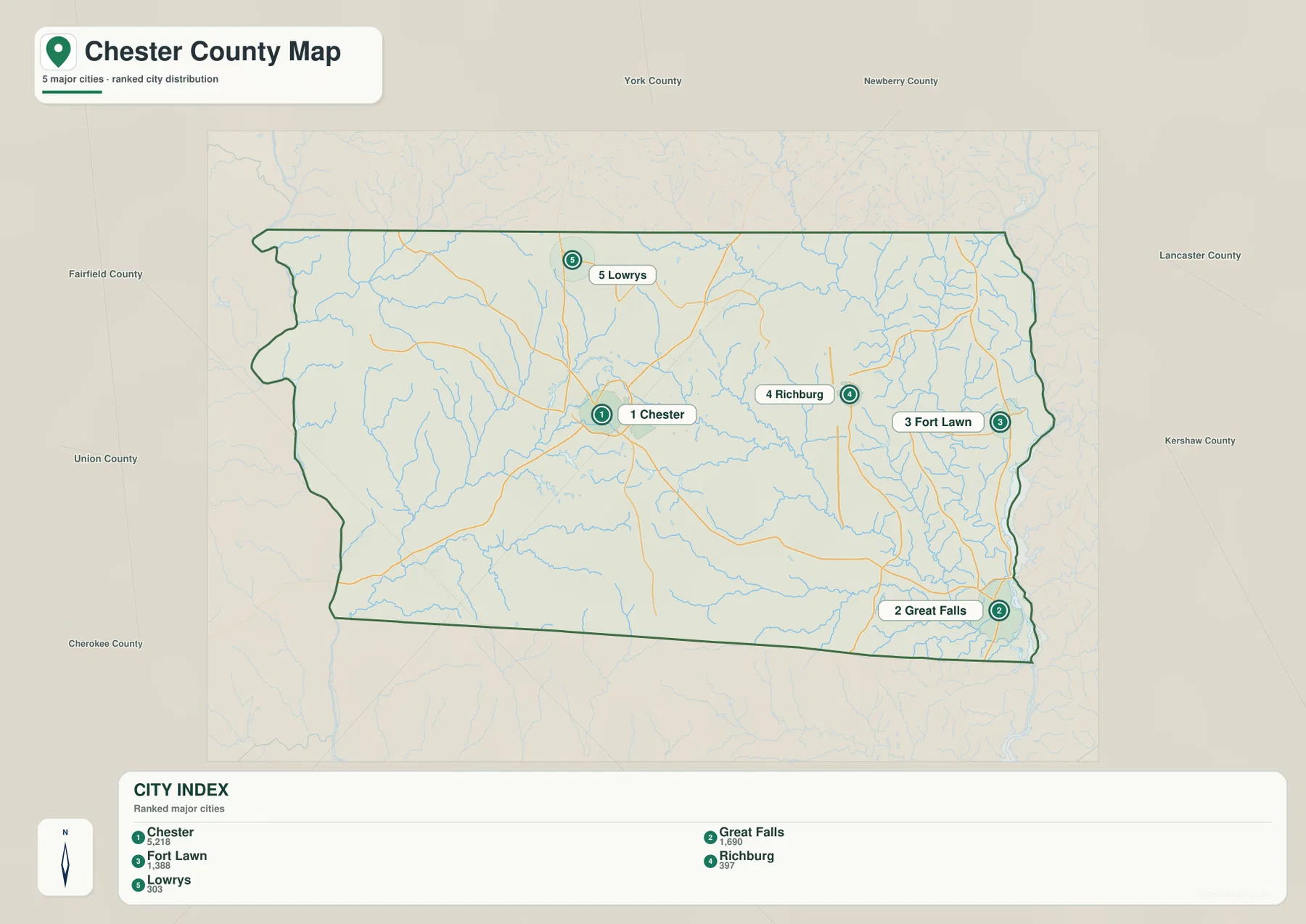
The city-distribution map numbers Chester as 1, Great Falls as 2, Fort Lawn as 3, Richburg as 4, and Lowrys as 5. The numbering functions as an index for this graphic, not as an administrative ranking. Chester is the most central of the five references, but the value of the map comes from seeing how far the other four move away from that center. The result is a county that reads differently north-to-south and east-to-west.
Lowrys is the northern reference and sits above Chester, making the Chester–Lowrys relationship the simplest pair to recognize. Richburg is east of Chester but still inland from the county’s far eastern edge. Fort Lawn lies farther east, while Great Falls is much farther south near the southeastern corner. Because those three eastern communities are staggered rather than lined up, the map prevents a common oversimplification in which the entire eastern side is treated as one place.
That staggered arrangement also prepares the reader for the water map. Fort Lawn and Great Falls both lie toward the Catawba River side, but Great Falls is considerably farther south. Richburg provides an intermediate inland reference between Chester and the eastern edge. Lowrys belongs to a different part of the county altogether, north of Chester and away from the main southeastern river-side grouping.
If the main question is simply where a community sits inside Chester County, this map is usually faster than the more detailed road map. Once the correct place is located, the general map can supply route context and the terrain-and-water map can supply river and creek context. That sequence is especially helpful for Great Falls and Fort Lawn because their relationship is more obvious when the city and water views are read together.
Catawba River on the east, Sandy River system to the west
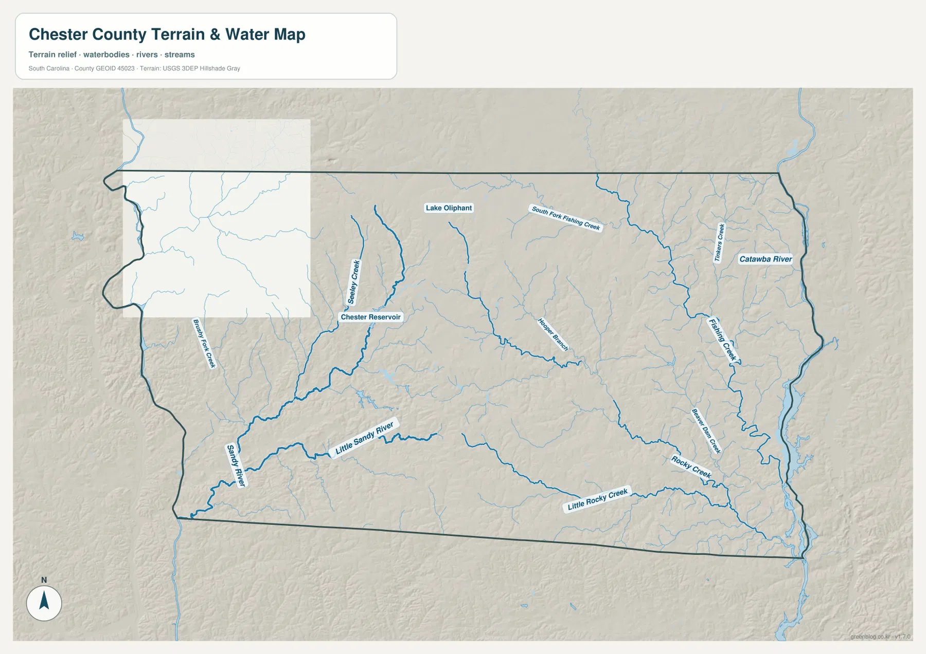
The Catawba River is the dominant water reference along the eastern side of the terrain-and-water map. It gives a natural geographic frame to the part of the county where Fort Lawn and Great Falls are located. From the interior, named tributaries such as Fishing Creek, South Fork Fishing Creek, Rocky Creek, and Little Rocky Creek feed through the eastern and southeastern landscape. Their branching pattern is visible even at county scale and shows why the river side contains much more than one continuous blue line.
The western and central portions have their own water landmarks. Sandy River and Little Sandy River are labeled in the southwest. Chester Reservoir lies west of Chester, and Lake Oliphant appears farther north. Those features are useful when a reader needs a local reference away from the Catawba corridor. They also keep the water story balanced: Chester County contains multiple creek and reservoir systems, not just the large river on its eastern side.
Shaded relief in the background adds a broad sense of terrain. Chester County is part of the Piedmont, so the surface is generally rolling rather than uniformly flat. Stream valleys cut through that surface, while the land between them rises gradually. The shading is designed to make those differences visible at a glance, not to provide a survey elevation for a specific property, bridge, or road. Exact elevation work requires a more specialized data product.
The same limitation applies to flood interpretation. The blue river and creek network does not show regulatory flood zones, expected inundation depths, or parcel-level risk. A community appearing close to a stream on this map is not enough evidence to make a flood decision. The reliable use of this file is narrower: identify the river, follow the named creeks, locate the reservoirs, and understand how those features sit within the county’s broad terrain.
Use the preview for quick reference and the JPG files for print
Choose the general county map when you need the boundary, Chester, the major road references, and the eastern communities in one view. Choose the city map when the task is to compare Chester, Great Falls, Fort Lawn, Richburg, and Lowrys without extra road detail. Choose the terrain-and-water file when the Catawba River, Fishing Creek system, Sandy River, Chester Reservoir, Lake Oliphant, or the county’s rolling surface is the subject.
- Boundary and roads: use the general map for Chester, US 321, SC 9, I-77, and the route pattern across the county.
- Community locations: use the city view for the relative positions of Chester, Great Falls, Fort Lawn, Richburg, and Lowrys.
- Rivers and terrain: use the terrain-and-water map for the Catawba River, named creeks, reservoirs, and broad relief.
The WebP versions are convenient for on-page viewing because they load at a practical display size. The downloadable archive contains the corresponding high-resolution A3 JPG files, which are better for printing, placing into a presentation, or comparing multiple South Carolina counties at a consistent scale. The subjects match the previews, so the county map section corresponds to the county JPG, the city section to the city JPG, and the water section to the terrain-and-water JPG.
You do not need to use all three files for every task. Someone comparing road access can stop with the general map, while a reader studying the Great Falls side of the county may benefit from pairing the city view with the water view. Keeping the files separate prevents small labels from competing with one another and makes each printable image more useful for its specific purpose.
Frequently Asked Questions
Which map is best for following Chester toward Richburg and Fort Lawn?
Start with the general county map. SC 9 provides a useful eastward reference from Chester toward Richburg, while Fort Lawn sits farther toward the eastern edge near Route 21 and the Catawba side. The city-distribution map is a good second view because it strips away most road detail and makes the difference between Richburg’s inland position and Fort Lawn’s farther-eastern position easier to see.
Why does Great Falls help orient the southeastern part of Chester County?
Great Falls is located near the southeastern corner and close to the Catawba River side of the county. Once it is found on the city map, the terrain-and-water map makes nearby southeastern creeks and the river corridor much easier to place. Fort Lawn provides a useful comparison farther north, so the two communities help show the vertical extent of Chester County’s eastern side.
Can the terrain-and-water map be used for flood zones or exact elevations?
No. It is a county-scale reference showing rivers, creeks, reservoirs, the county outline, and broad shaded relief. It does not provide regulatory flood boundaries, inundation depths, parcel limits, or survey-grade elevation measurements. Use current official flood products, property records, or survey data when a decision depends on those details.
Map File Information
Download the Chester County county map, city-distribution map, and terrain-and-water map as high-resolution A3 JPG files. The ZIP contains three JPG files matching the previews on this page.
- Included Files: 3 high-resolution A3 JPG map files shown in this article
- File Type: JPG files in a ZIP archive
- Intended Use: Printing, education, presentations, and map-based projects
Related Maps
Official sources and reference data
- South Carolina Association of Counties – Chester County: county formation, county seat, municipalities, and basic profile information
- U.S. Census Bureau – Chester County Profile: 2020 population, land area, and adjacent counties
- U.S. Census Bureau TIGER/Line Shapefiles: county boundaries, roads, and geographic reference data
- USGS National Hydrography: rivers, streams, and water-feature reference data
- South Carolina Revenue and Fiscal Affairs Office – County Boundary Program: official South Carolina county-boundary information
Green Map creates custom-edited map images using open geographic data sources such as geoBoundaries, Natural Earth, OpenStreetMap, and government open data.
These maps are edited visual materials, not raw data files, and are provided for education, documents, presentations, and graphic reference.