Macoupin County spreads its towns across a large part of west-central Illinois rather than concentrating them around one continuous urban area. Carlinville sits close to the center and serves as the easiest reference point, while Virden is far to the northeast, Staunton and Mount Olive are in the southeast, and Brighton is near the southwest corner. Palmyra and Shipman mark the western half, and Gillespie and Bunker Hill add important southern reference points.
This page shows how those communities connect with the road network, Macoupin Creek and its tributaries, several named lakes and reservoirs, and a terrain range of roughly 145 to 234 meters. The WebP maps are placed in the article for quick viewing, and the same four maps are available below as high-resolution JPG files in one downloadable ZIP. The set is especially useful for comparing Carlinville with the southeastern towns and for seeing how the county’s deepest creek valleys cut through otherwise higher ground.
Table of Contents
Carlinville gives the road map a practical center
Carlinville is near the middle of the county map and sits where several routes meet or pass nearby. Route 108 comes in from the west and continues through the Carlinville area toward the eastern side of the county. Route 4 heads southeast toward Gillespie, while the northbound route through Palmyra reaches the upper half of the county. Virden has a separate north-south road corridor near the northeastern boundary, so the county does not depend on one single highway spine.
The southern half is more densely labeled. Gillespie lies southeast of Carlinville, with Mount Clare and Staunton farther south. White City and Mount Olive are to the east, and Route 138 crosses the southeastern group of communities. Route 55 runs north-south near Mount Olive on the county’s eastern side. Farther west, Bunker Hill and Brighton form a different southern cluster, separated from the Staunton-Mount Olive area by a broad interior of smaller roads and drainage lines.
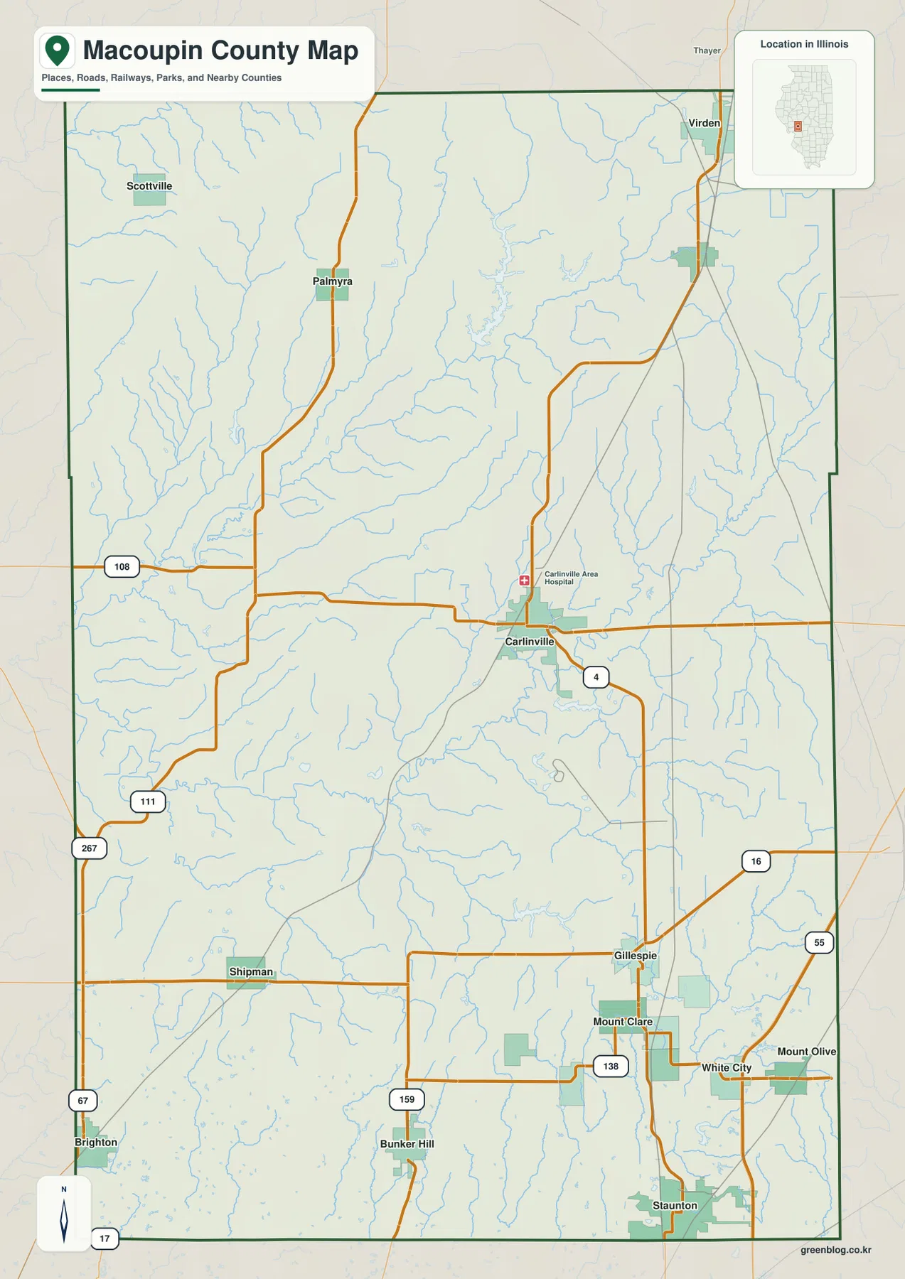
The western side adds Palmyra, Shipman, and Brighton as useful location markers. Routes 111 and 267 appear along the southwestern side, while Route 67 passes the Brighton area. These roads make the western communities easier to distinguish from the Carlinville and southeastern systems. The map is intended for geographic orientation rather than live navigation, so current routing, closures, and travel times should still be checked with a dedicated road service.
Six ranked cities form three very different parts of the county
The ranked city map highlights six communities. Its index lists Carlinville at 5,480, Staunton at 4,298, Virden at 3,171, Gillespie at 2,815, Brighton at 2,306, and Mount Olive at 1,872. Carlinville occupies the center, Virden is isolated in the northeast, and Brighton sits at the southwest edge. Staunton, Gillespie, and Mount Olive are the only three of the six that form a relatively close southeastern group.
Even within that southeastern group, the towns are clearly separated. Gillespie is the northernmost of the three, Staunton lies farther south, and Mount Olive is east of Staunton. The general county map fills in smaller places between and around them, including Mount Clare and White City. Virden, by contrast, sits well away from this southern cluster and close to the northeastern county line, while Carlinville remains the central hinge between the north, west, and southeast.
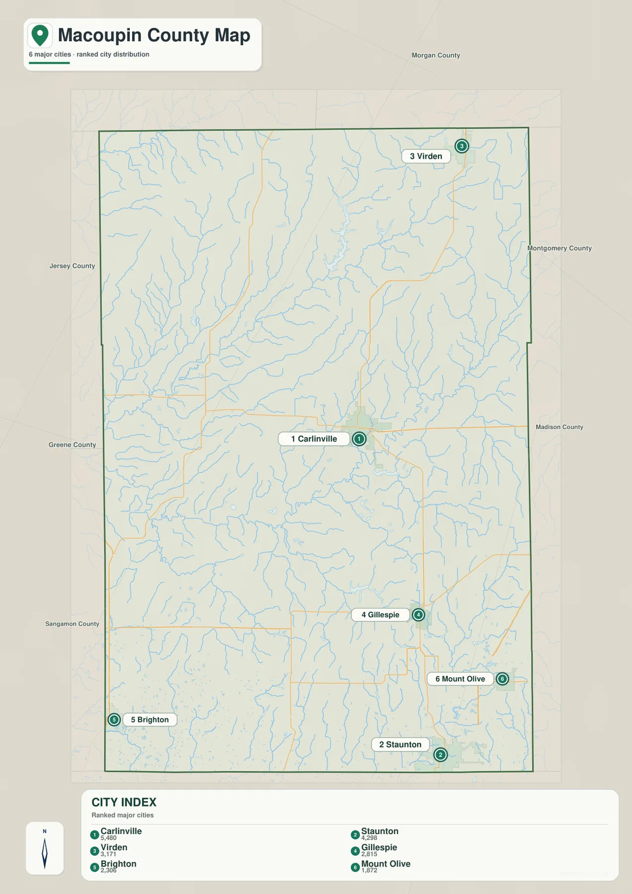
The simplified city view works best when it is paired with the more detailed county map. Palmyra, Shipman, Bunker Hill, Mount Clare, and White City do not appear among the six ranked cities, but they help explain the gaps between the larger places. Reading the two maps together makes it easier to see that Macoupin County is made up of several distinct settlement areas rather than one uninterrupted urban corridor.
Macoupin Creek and Bear Creek carve the county’s central valleys
The terrain and water map is dominated by two named creek systems across the middle of the county. Bear Creek enters from the west and follows a broad valley toward the Carlinville area. Macoupin Creek bends across the central-eastern part of the county, and Hurricane Creek joins the same general drainage area. Their valleys are wide enough to stand out clearly when the water map is compared with the elevation colors.
Several lakes and reservoirs add a second layer to the county’s water geography. Lake Carlinville and Smith Lake sit near Carlinville, while Beaver Dam Lake lies farther west. Otter Lake and Sunset Lake are close to one another in the north-central part of the county, and Bunn Lake is farther northwest. To the south, New Gillespie Lake and Staunton Reservoir mark additional local water bodies. The result is a county with many separate lakes connected to different small drainage systems rather than one dominant reservoir.
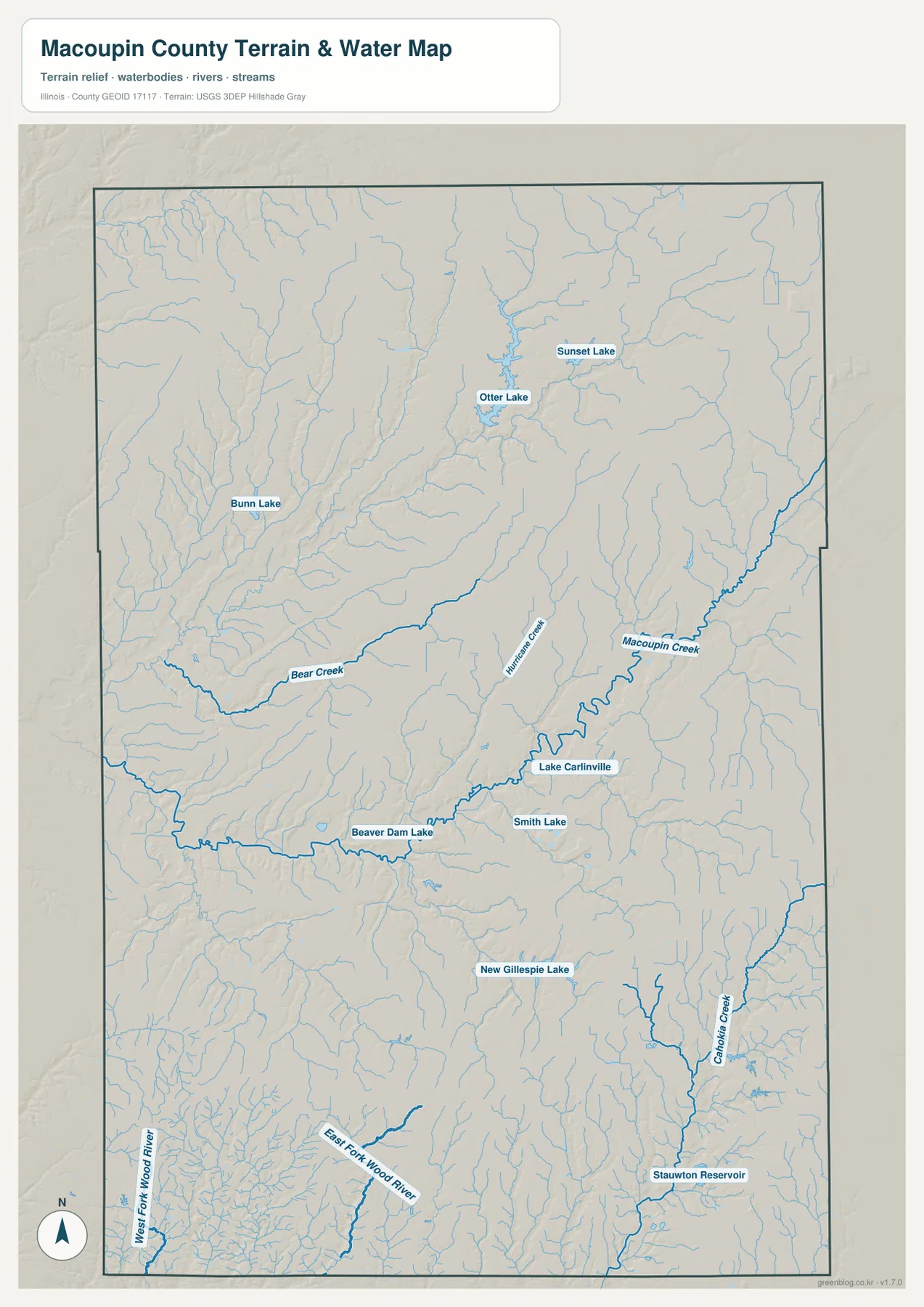
Other drainage lines help distinguish the southern corners. Cahokia Creek runs through the southeast, while the West Fork Wood River and East Fork Wood River appear in the southwest. Those streams belong to different local drainage directions from the central Macoupin Creek system. This map is a geographic reference, not a flood-risk map, legal water-boundary document, navigation chart, or drainage-engineering product.
The 145–234 m elevation map reveals deep western and central drainage cuts
The elevation map reports an actual range of about 145 to 234 meters and a mean near 191 meters. The strongest green lowlands spread through the western and central parts of Macoupin County, following a wide network of creek valleys. Bear Creek and Macoupin Creek occupy some of the most obvious low corridors, with many smaller tributary valleys branching away from them. The relief is not mountainous, but the drainage network has cut enough into the uplands to create a strongly textured surface.
Higher tan and brown ground is broadest across the north, northeast, and eastern side of the county. The difference is especially clear where narrow green valleys cut into those higher areas. The south is also broken by numerous small drainage channels rather than forming one level plain, and the Staunton Reservoir area creates another long lower corridor in the southeast. Macoupin County is therefore easier to understand as a set of uplands divided by creek valleys than as a landscape that simply rises from south to north.
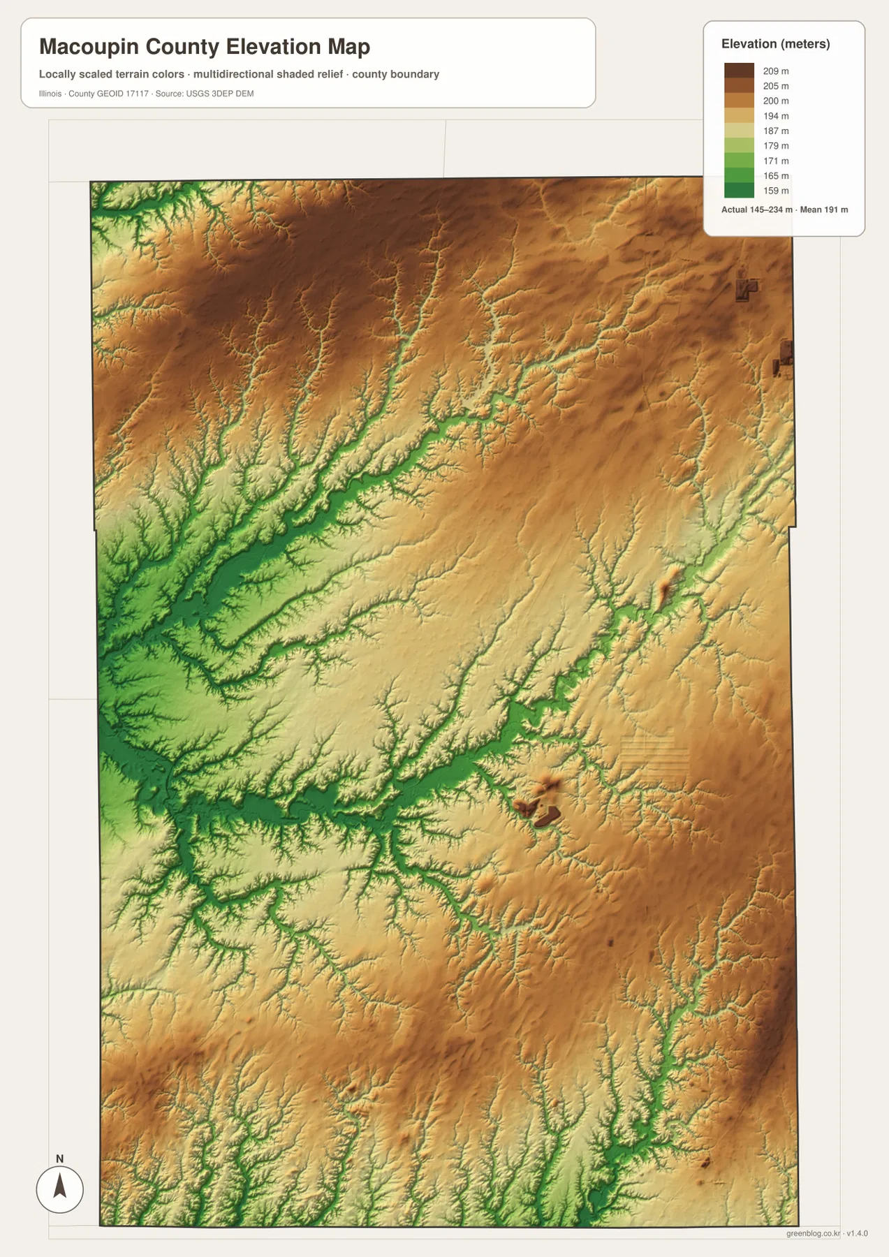
The elevation surface is generalized for county-scale comparison. It should not be treated as survey-grade height, parcel elevation, or an engineering model. For ordinary map reading, however, it explains the water map well: Macoupin Creek, Bear Creek, and many tributaries follow the lower green corridors, while Carlinville and the surrounding roads sit among a mix of valley floors and gently higher interior ground.
Following one place across the maps makes the county easier to understand
For roads, boundaries, and the full set of labeled settlements, begin with the county map. The ranked city map is better when the question is simply how Carlinville, Virden, Brighton, and the southeastern cities are distributed. Use the water map for Macoupin Creek, Bear Creek, the Carlinville-area lakes, and the northern lakes. The elevation map then explains why so many of those streams follow deep green valleys between higher uplands.
Carlinville is a good example of how the four views connect. The county map shows its central road position, the city map establishes it as the largest highlighted community, the water map places Lake Carlinville and Macoupin Creek nearby, and the elevation map shows the surrounding low drainage corridors. Staunton offers a different comparison: it belongs to the southeastern city group, sits near the road network that continues toward Mount Olive, and lies close to Staunton Reservoir and the lower terrain around that water system.
Frequently Asked Questions
Which map best shows how Carlinville, Virden, Brighton, and Staunton are separated?
The ranked city map is the quickest comparison. Carlinville is central, Virden is near the northeast corner, Brighton is in the southwest, and Staunton is part of the southeastern group with Gillespie and Mount Olive. Switch to the county map when you also want to see the roads and smaller communities between those larger places.
Why do Macoupin Creek and Bear Creek stand out on the elevation map?
Both creeks follow some of the county’s deepest low corridors. The elevation map shows those valleys in green, while much of the northern and eastern upland is tan or brown. Comparing the water and elevation maps makes the connection especially clear because the named creeks and many smaller tributaries line up with the lower terrain.
What is included in the downloadable ZIP?
The ZIP contains four high-resolution JPG files: the county and road map, ranked city map, terrain and water map, and elevation map. Each file is 2572 × 3638 pixels. The smaller WebP versions are used in the article for faster viewing, while the JPG files are better for close inspection and print. The water and elevation maps remain general geographic references rather than flood, legal-boundary, survey, or engineering products.
Map File Information
Download the Macoupin County county map, ranked city map, terrain and water map, and elevation map together as high-resolution JPG files.
- Included Files: Use only the versions confirmed in the article and supplied images
- File Type: Use the confirmed download contents
- Intended Use: Printing, education, presentations, and map-based projects
Related Maps
Sources and references
- U.S. Census Bureau TIGER/Line Shapefiles – county boundaries, roads, and place reference
- USGS National Hydrography – streams, lakes, reservoirs, and other hydrography reference
- USGS 3D Elevation Program – elevation and terrain reference
- Macoupin County Tourism Information – county information including Carlinville, Otter Lake, Beaver Dam State Park, and Route 66
- City of Carlinville Tourism – local information on Route 66, historic sites, and visitor resources in Carlinville
Green Map creates custom-edited map images using open geographic data sources such as geoBoundaries, Natural Earth, OpenStreetMap, and government open data.
These maps are edited visual materials, not raw data files, and are provided for education, documents, presentations, and graphic reference.