You can download the Macon County map files from this page as one ZIP containing four high-resolution JPGs. The maps center on Decatur and show how Forsyth, Mount Zion, Harristown, Long Creek, Maroa, and other communities sit around the county, while Lake Decatur and the Sangamon River give the central landscape a strong water-and-valley pattern.
The article uses WebP versions for quick viewing before the full-size files are needed. The county and road map is best for orientation around Decatur, the ranked city map simplifies the main population centers, the terrain and water map traces Lake Decatur and nearby creeks, and the elevation map shows a roughly 171–229 meter range from lower river corridors to higher interior ground.
Table of Contents
Decatur as the road and settlement center of Macon County
The county map makes Decatur the most obvious reference point. Route 51 passes north and south through the central area, while Route 36 enters from the west near Harristown and Niantic. Route 105 continues east toward Long Creek, and Route 121 serves the Mount Zion side of the county. In the northeast, Routes 48 and 72 appear around Oreana and Argenta, creating a separate road pattern from the routes that converge around Decatur.
The western boundary is stepped rather than perfectly rectangular, which helps explain why Warrensburg, Niantic, and the southwestern settlements do not line up in one corridor. Boody is south-southwest of Decatur, and Macon lies farther south. North of the city, Forsyth sits very close to the developed Decatur area, while Maroa is much farther away near the northern edge. These differences are easy to miss in a simple list of place names but become obvious on the county map.
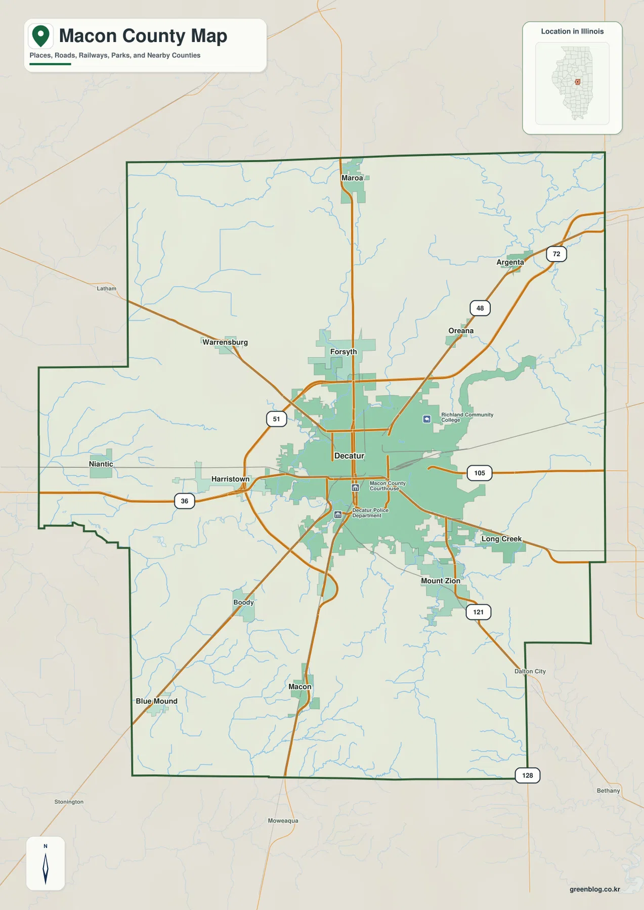
Argenta and Oreana are useful northeastern reference points because they sit beyond the main Decatur-Forsyth cluster. Mount Zion and Long Creek are closer to the city but lie on different sides of the lake and road system. For a reader who wants to understand the county before looking at water or elevation, this view provides the best overall orientation. It is not a turn-by-turn navigation map, so current routing and traffic should be checked with a dedicated travel service.
Six highlighted cities from Maroa in the north to Mount Zion in the southeast
The ranked city map reduces the labels to six highlighted places. Its index lists Decatur at 69,815, Mount Zion at 5,660, Forsyth at 3,502, Maroa at 1,714, Harristown at 1,550, and Long Creek at 1,392. Decatur is both the largest highlighted place and the central anchor. The remaining five are distributed in several directions, so the map reads more like a hub with separate outer communities than a single straight chain of towns.
Forsyth is the closest of the six to Decatur and sits directly north of it. Maroa is farther north near the county’s upper edge, while Mount Zion occupies the southeast. Harristown lies west of Decatur, and Long Creek is east. These positions make the ranked map useful for a quick comparison: the reader can see which communities are close to the center and which ones represent the outer parts of the county without the extra road and creek labels of the general map.
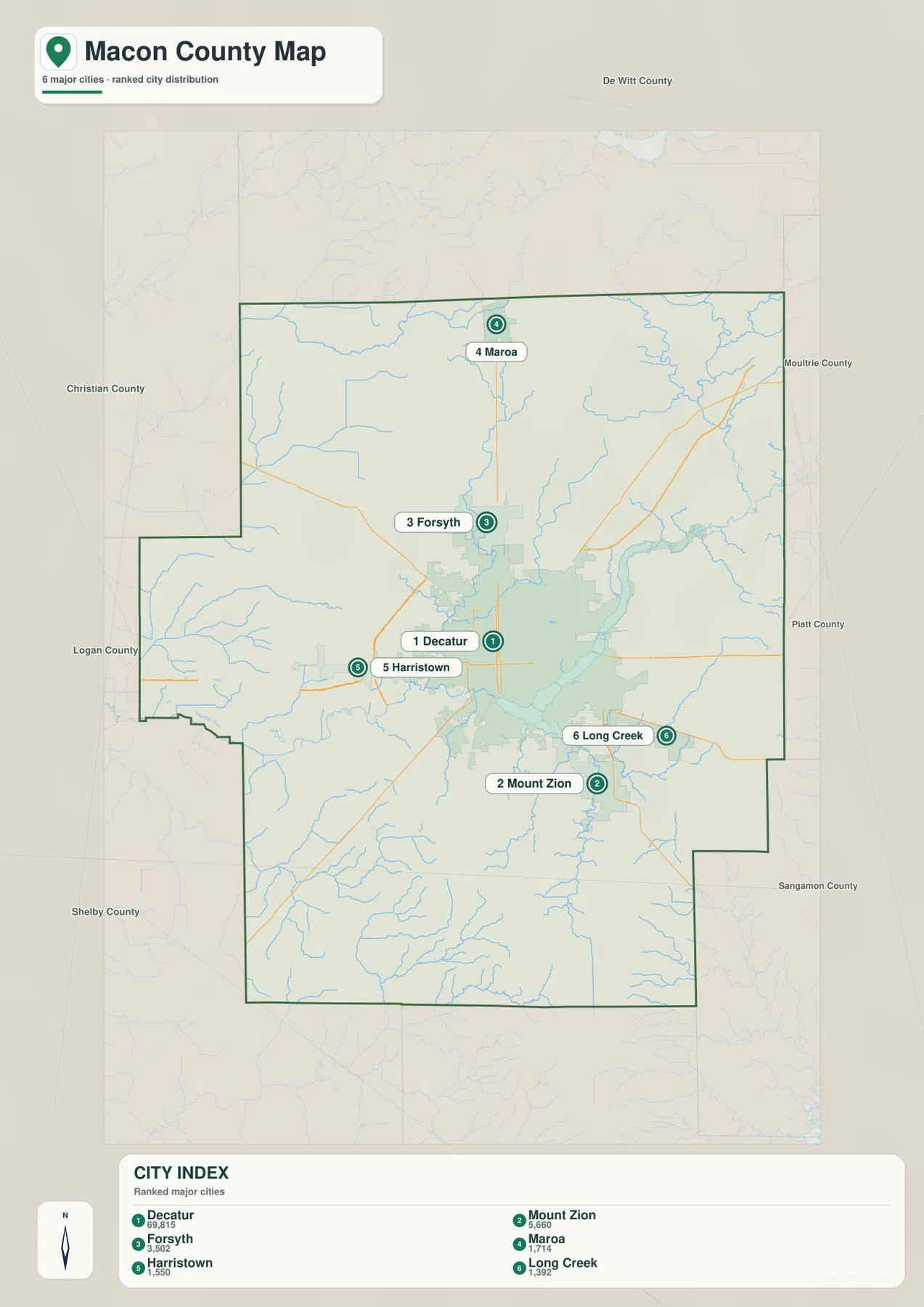
The city map becomes more useful when it is paired with the county map. Find Mount Zion on the simplified city view, then switch back to the road map to see Route 121 and the developed area southeast of Decatur. Do the same with Harristown and Route 36 or with Forsyth and the northbound roads. This back-and-forth approach adds geographic context without turning the ranked map into a crowded reference sheet.
Lake Decatur and the Sangamon River through the middle of the county
Water is one of the strongest geographic features on the Macon County maps. The Sangamon River enters from the west, crosses the central part of the county near Lake Tokorozawa, and continues into Lake Decatur. East of the lake, the river bends again toward the northeast. Because this large water body sits so close to Decatur, the relationship between the central city, the lake, and the river is much more visible here than on a map that only shows municipal boundaries.
Several named creeks feed or cross the surrounding landscape. Spring Creek and Stevens Creek are labeled north and northwest of Lake Decatur, with Kickapoo Creek and Friends Creek farther northeast. Lake Fork Creek and South Fork appear in the northwestern part of the county, while Willow Branch is farther west. South of the central lake-and-river corridor, Mosquito Creek, Sand Creek, and Finley Creek are visible, and Long Creek runs through the eastern side.
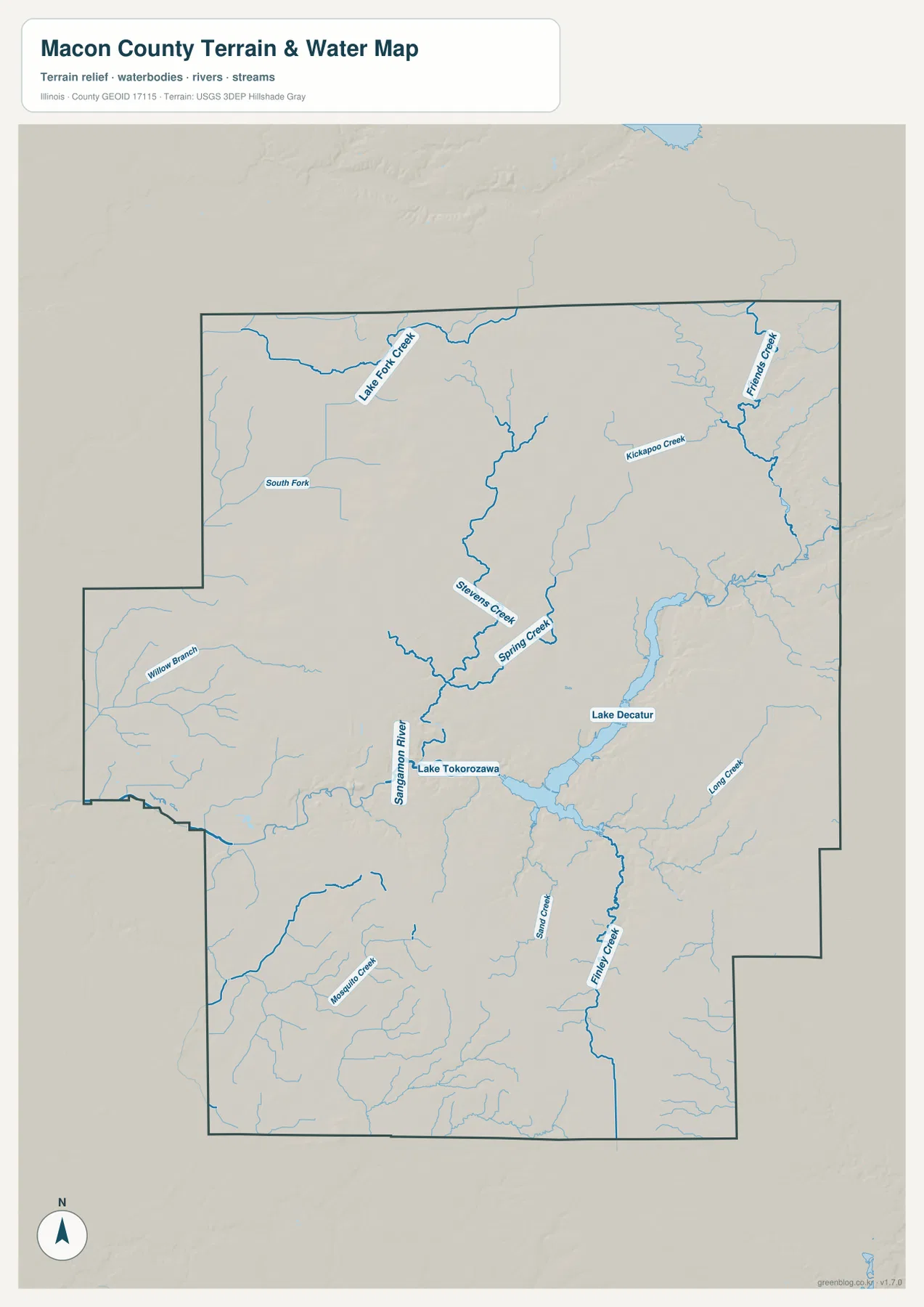
This is a geographic water-reference map rather than a flood map, legal water-boundary document, navigation chart, or drainage-engineering product. Its main value is comparative. When the same area is viewed on the elevation map, the Sangamon River and Lake Decatur line up with lower green corridors, while many of the surrounding tan and brown areas sit higher above the valley.
A 171–229 m surface shaped by river valleys and higher interior ground
The elevation map gives Macon County an actual range of about 171 to 229 meters, with a mean near 203 meters. The lowest greens are broadest in the west and along the Sangamon River-Lake Decatur corridor. Higher tan and brown terrain appears across much of the north-central interior and again toward the east and southeast. The county is not mountainous, but the river valleys create enough local relief to make the height changes easy to see.
Lake Decatur is an especially useful landmark for comparing elevation. The lake and the river channel form a long low band through the center and east-central part of the county. Moving away from that band, the colors rise into yellow, tan, and brown on both sides. The north-central area contains a compact zone of stronger relief, while the southeastern edge also reaches some of the higher mapped elevations. The western side remains lower overall, producing a clear contrast with the higher interior.
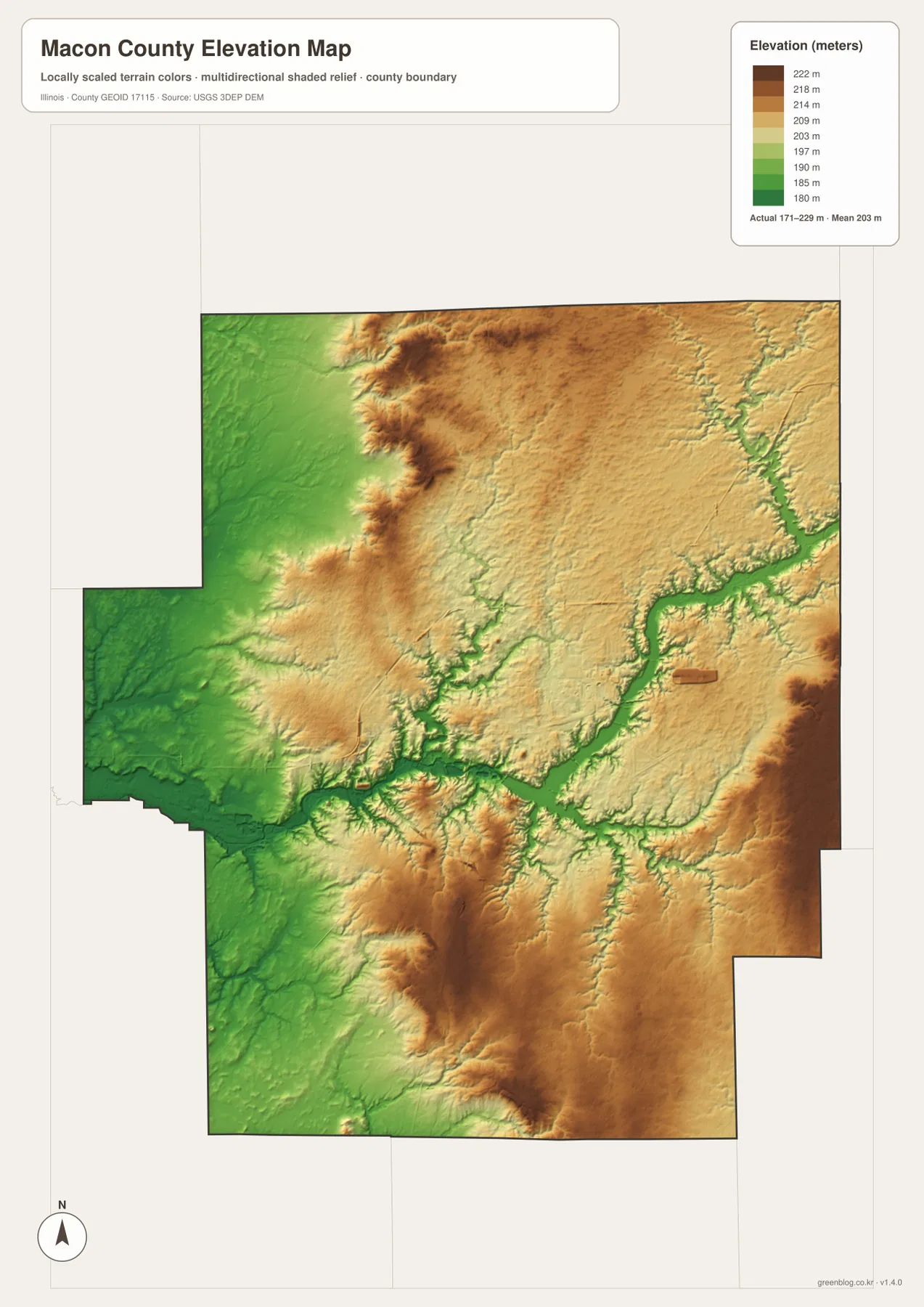
The elevation surface is generalized for county-scale comparison and should not be treated as a survey, parcel elevation, or engineering model. For ordinary map reading, however, it adds an important layer of context. The lower route of the Sangamon River becomes easier to recognize, and the hills around the drainage lines stand out more clearly than they do on the road map alone.
How to combine the four views without repeating the same information
Start with the county map if the question is where Decatur, Forsyth, Mount Zion, Harristown, Long Creek, and the outlying towns sit in relation to the road network. Use the ranked city map when the extra labels are unnecessary and the goal is simply to compare the six highlighted communities. The water map is the clearest source for Lake Decatur, the Sangamon River, and the named creeks, while the elevation map explains the low river corridor and the higher interior terrain.
Following one place across several maps can be more informative than reading each map separately. Decatur is a good example: the road map shows its central position, the city map confirms its dominance among the highlighted communities, the water map places it beside Lake Decatur and the Sangamon River, and the elevation map shows that the central water corridor lies below much of the surrounding interior. The same method works for Mount Zion, Forsyth, or Long Creek and keeps the maps tied to real places rather than abstract map categories.
Frequently Asked Questions
Which map is best for comparing Decatur, Forsyth, and Mount Zion?
The ranked city map is the quickest option. Decatur is central, Forsyth is directly north, and Mount Zion is southeast. Harristown, Long Creek, and Maroa provide western, eastern, and northern reference points. If road context is important, switch to the county map after locating the cities so you can see the numbered routes and smaller settlements around them.
How are Lake Decatur and the Sangamon River connected on the map?
The terrain and water map shows the Sangamon River entering from the west and continuing through the central lake system before bending northeast beyond Lake Decatur. Spring Creek, Kickapoo Creek, and several other named streams appear around the same system. On the elevation map, the lake and river follow a long low corridor that is visibly lower than much of the surrounding interior.
What files are included in the downloadable ZIP?
The ZIP contains four high-resolution JPG files: the county and road map, ranked city map, terrain and water map, and elevation map. Each image is 2572 × 3638 pixels. The article uses smaller WebP versions for faster on-screen viewing. The water and elevation maps are general geographic references and should not replace official flood, legal-boundary, survey, or engineering products.
Map File Information
Download the Macon County county map, ranked city map, terrain and water map, and elevation map together as high-resolution JPG files.
- Included Files: Use only the versions confirmed in the article and supplied images
- File Type: Use the confirmed download contents
- Intended Use: Printing, education, presentations, and map-based projects
Related Maps
Sources and references
- U.S. Census Bureau TIGER/Line Shapefiles – county boundaries, roads, and place reference
- USGS National Hydrography – rivers, creeks, and other hydrography reference
- USGS 3D Elevation Program – elevation and terrain reference
- City of Decatur – Enjoying Lake Decatur – official information about Lake Decatur
- Decatur Convention & Visitors Bureau – visitor and local information for Decatur, Forsyth, and Macon County
Green Map creates custom-edited map images using open geographic data sources such as geoBoundaries, Natural Earth, OpenStreetMap, and government open data.
These maps are edited visual materials, not raw data files, and are provided for education, documents, presentations, and graphic reference.