You can download the four high-resolution Lake County map JPGs on this page together in one ZIP file. Lake County occupies the northeastern corner of Illinois, where Lake Michigan forms the long eastern edge and inland lakes, towns, roads, streams, and preserved open space spread westward. Waukegan and North Chicago sit close to the lakeshore, while Gurnee, Libertyville, Mundelein, and Grayslake provide useful reference points farther inland. The maps below bring those settings together so you can compare the county boundary, major roads, settlement locations, waterways, and elevation without switching between unrelated sources.
The county changes noticeably from east to west. Along Lake Michigan, the shoreline is comparatively simple and the terrain is low. In the northwest, Channel Lake, Lake Marie, Grass Lake, Long Lake, and many smaller water bodies create a much more broken landscape. Between those two settings, the Des Plaines River passes through the interior, while major roads connect Waukegan and Gurnee with communities such as Libertyville, Mundelein, Antioch, and Highland Park. Looking at the maps together makes that contrast much easier to understand than a single road map alone.
The four supplied maps are designed for different questions. The general county map is best for roads, settlement names, public landmarks, and the county outline. The ranked city map strips away much of that detail and focuses on six major mapped communities. The terrain-and-water map highlights the concentration of inland lakes, the Des Plaines River, smaller streams, and the Lake Michigan edge. Finally, the elevation map shows an actual county range of about 176 to 290 meters, with the lowest ground along the eastern shore and higher uplands across much of the western interior.
Table of Contents
Roads connect the Waukegan shoreline with Gurnee, Libertyville, and the western interior
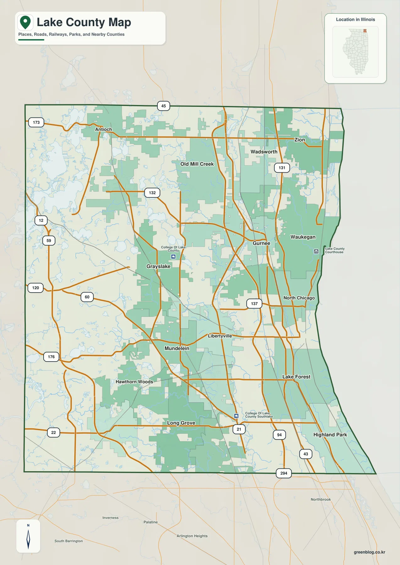
Waukegan is the easiest eastern anchor on the general map. It sits close to Lake Michigan, with Zion to the north and North Chicago, Lake Forest, and Highland Park extending south along the same side of the county. The Lake County Courthouse marker appears in Waukegan, while Gurnee is located a short distance inland. Once those two places are found, the rest of the eastern half becomes much easier to organize because most of the major road connections can be followed from them.
Gurnee stands out as a road junction in the east-central part of the county. Route 132 crosses this area from the Grayslake side, and several north-south routes continue through or near the eastern communities. Farther south, the map shows 21, 43, 94, and 294, providing a broad picture of how the southern part of Lake County connects toward the larger Chicago region. In the north, Route 173 runs from the Antioch side toward Zion, while 45 gives the interior a useful north-south reference line.
Libertyville and Mundelein help define the inland center-south area. Grayslake lies farther north and is marked near the College of Lake County. Hawthorn Woods and Long Grove provide additional references closer to the southern and southwestern side. These communities are useful because the county is not organized around one single corridor. The road pattern branches between the Lake Michigan shore, the central towns, and the lake-rich western half, so readers gain more by learning a few anchor places than by trying to memorize every highway number.
The northwest is visibly different from the eastern lakeshore. Around Antioch and the western side of the county, roads weave between many water bodies instead of crossing an uninterrupted urban grid. Routes 12 and 59 provide north-south references on the west, while 120, 60, 176, and 22 cross parts of the county from east to west. This network shows why Lake County is better understood as several connected settings—shoreline cities, central and southern suburbs, and a western interior shaped by lakes and open space.
Large green areas also appear throughout the general map. They are particularly noticeable around the central and eastern portions of the county, where preserved land and parks sit among developed communities. The Lake County Forest Preserves reports protecting more than 31,900 acres countywide, which helps explain why open-space patches remain a prominent part of the map. The general map is still not a trail guide, so anyone visiting a preserve should use the current official preserve map for entrances, routes, and access conditions.
This road map works best as a county-scale reference rather than turn-by-turn navigation. It can answer questions such as whether Antioch is north or west of Waukegan, how Grayslake relates to Gurnee, or where Highland Park sits within the county. Current travel times, construction, closures, and exact street-level routing require a live navigation service. For a classroom handout, regional overview, or first-stage trip plan, however, the simplified network is much easier to scan than a fully detailed street map.
Six mapped communities reveal more than one population center
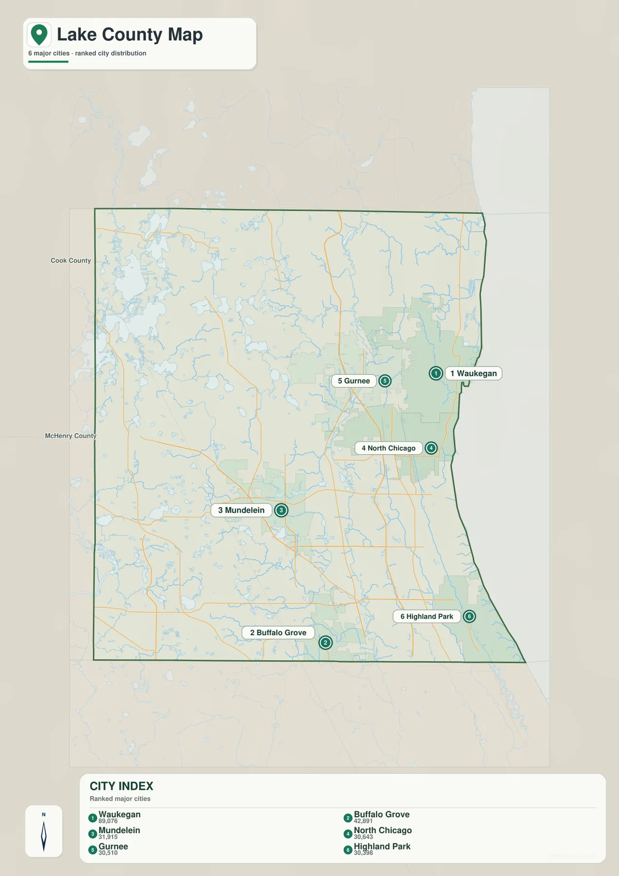
The city-distribution map removes most secondary place labels and lets six communities stand out. Waukegan is ranked first and appears near the Lake Michigan shore. North Chicago is south of it, while Gurnee sits farther inland. Mundelein occupies the interior south of center. Buffalo Grove and Highland Park are both in the southern part of the map, but they sit on opposite sides, with Buffalo Grove to the southwest and Highland Park close to the lakeshore.
The CITY INDEX lists Waukegan at 89,076, Buffalo Grove at 42,891, and Mundelein at 31,915. North Chicago is shown at 30,643, Gurnee at 30,510, and Highland Park at 30,398. These figures should be treated as the reference values printed on the supplied map, not as a claim about the latest official population count. Boundaries, estimates, and census dates can differ, so a current population question should be checked against the Census Bureau or the relevant municipality.
The arrangement of the six markers is more useful than the ranking alone. Waukegan and North Chicago form a clear eastern pair close to the shore, while Gurnee and Mundelein show that substantial communities also sit well inland. Buffalo Grove pulls the pattern toward the southwest, and Highland Park brings it back to Lake Michigan in the southeast. The result is a county with several strong settlement clusters rather than a single dominant center surrounded by empty space.
Several familiar names from the general map do not appear in the six-city ranking. Antioch, Zion, Libertyville, Grayslake, Lake Forest, and other communities are still important for orientation even though they are not included in this simplified index. That is why the city map is most effective as a companion rather than a replacement. Use it to understand the broad distribution, then return to the general map for roads, additional towns, parkland, and public landmarks.
The simplified map is particularly helpful when explaining the county to someone unfamiliar with northern Illinois. A reader can quickly see that Waukegan is on the eastern side, Gurnee and Mundelein are inland, and Buffalo Grove and Highland Park occupy different parts of the south. After that basic picture is established, the water map adds a new layer by showing why the northwest looks more fragmented and why the eastern settlements sit beside a very different water environment.
Inland lakes and the Des Plaines River contrast with the Lake Michigan edge
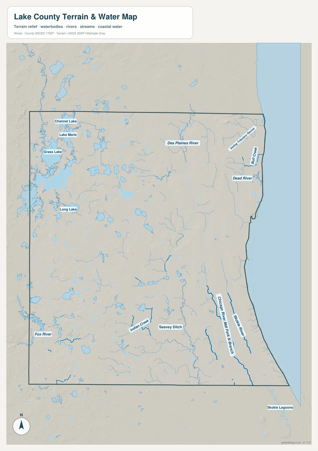
The water map makes the county’s name feel literal. In the northwest, Channel Lake, Lake Marie, and Grass Lake are grouped close together, and many additional small water bodies fill the surrounding area. Long Lake appears farther south, with more unnamed lakes scattered through the western half. Once road symbols and city labels are reduced, this concentration becomes one of the strongest visual features in the county.
The Des Plaines River provides a different kind of water feature. Instead of forming a cluster, it runs through the north-central and eastern interior and continues south. Readers who first locate Wadsworth, Gurnee, and Libertyville on the road map can use those places to understand the river’s general position. The Lake County Forest Preserves also identifies the Des Plaines River Trail and Greenway as a major north-south recreational corridor, reinforcing the importance of this river route in the county’s landscape.
Smaller streams become easier to see near the Lake Michigan side. Bull Creek and the Dead River are labeled in the northeast, while the Skokie River runs through the southeastern part of the county. Farther south, the Middle Fork North Branch of the Chicago River appears as another narrow watercourse. None of these waterways dominates the whole county, but together they show that the lakeshore lowland contains its own network of streams in addition to the much larger lake beside it.
The Fox River is labeled near the southwestern edge rather than through the county center. It is therefore more useful as a western reference than as the main organizing river for Lake County. Indian Creek and Seavey Ditch are also visible in the southern interior, adding smaller drainage lines between the larger water systems. The map makes it clear that the county contains both lake-dense terrain and long river corridors, rather than one uniform drainage pattern.
Lake Michigan is the largest water feature by far. Its shoreline forms the eastern side of the county, beside Waukegan, North Chicago, Lake Forest, and Highland Park. That edge contrasts sharply with the west, where the landscape is broken into many smaller lakes and irregular stream valleys. The difference helps explain why a map focused only on roads misses an important part of Lake County’s geography: water shapes both the county boundary and much of the interior.
This water map should be used for location and geographic context, not for legal or real-time decisions. It does not define floodplain limits, wetland jurisdiction, water quality, boating rules, or current river stages. Those questions require current government sources created for the specific purpose. For a regional report, classroom project, or general county overview, the map is valuable because it shows the relative positions of lakes, streams, and major rivers without the clutter of a full street network.
Elevation rises from the Lake Michigan lowland toward the western uplands
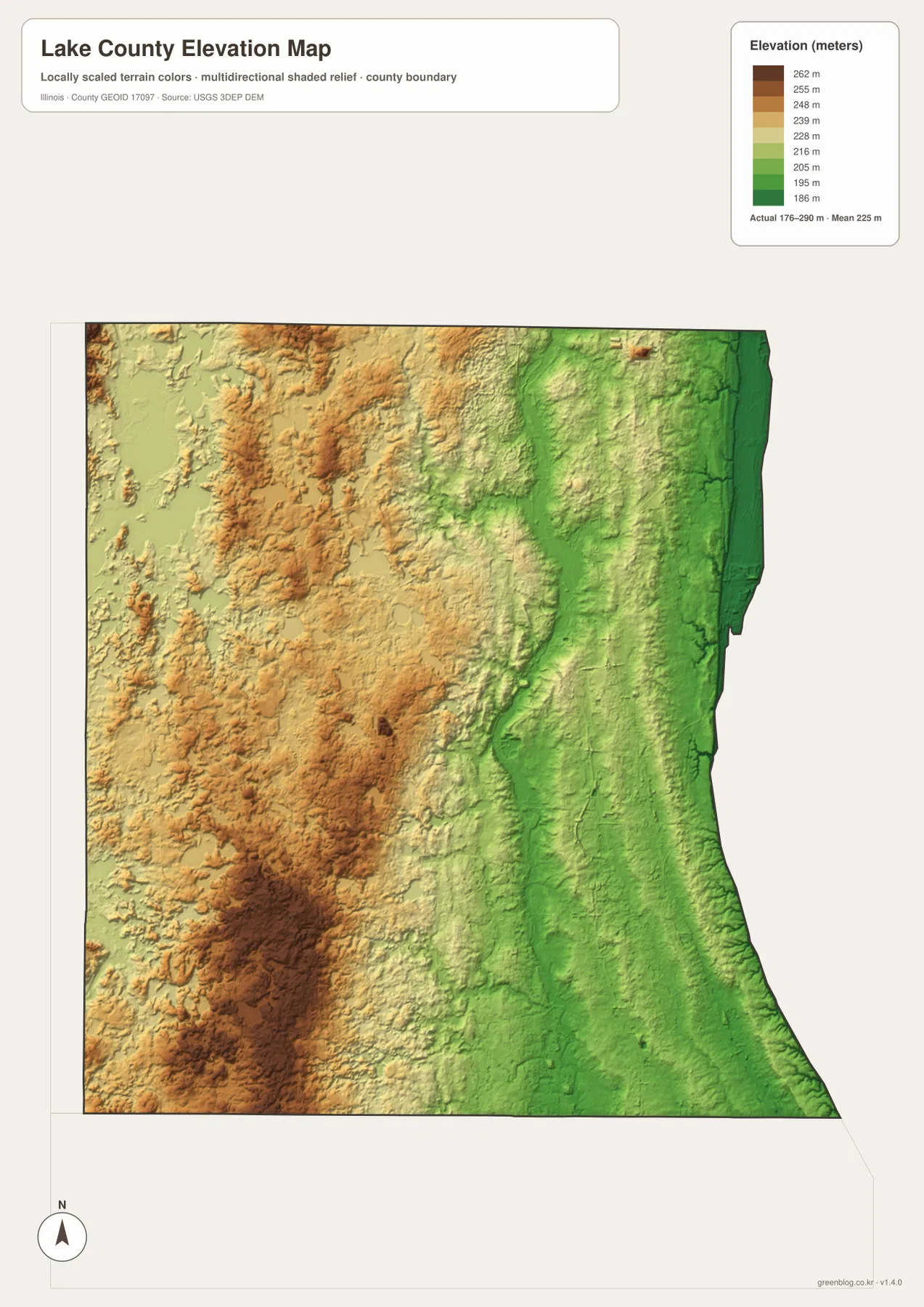
The elevation legend gives an actual range of about 176 to 290 meters and a mean near 225 meters. The broad pattern is easy to read even without knowing every local ridge. Darker green follows the Lake Michigan side, where the lowest terrain occurs. Moving west, colors transition through lighter green and yellow into tan and brown, marking higher interior ground. The county is not mountainous, but the difference between the shoreline and western uplands is large enough to be visually obvious.
The eastern lowland is not perfectly uniform. Narrow low corridors extend inland along streams, and the Des Plaines River corridor also appears lower than some of the surrounding ground. Comparing the elevation image with the water map turns those green bands into recognizable valleys rather than unexplained color changes. That comparison is one of the most useful ways to read the two maps together.
Higher colors become more common across the western and west-central interior. The terrain around and west of the Grayslake–Mundelein area contains broad patches of higher ground, with smaller valleys cutting between them. Farther northwest, the many lakes occupy a landscape that is still uneven rather than flat. Water-filled depressions, short valleys, and higher surrounding areas combine to produce a much more varied surface than the general road map suggests.
The elevation map also helps separate shoreline position from inland position when comparing communities. Waukegan and North Chicago lie near the low eastern edge, while Mundelein and Grayslake are farther into the higher interior. Highland Park is again close to Lake Michigan in the southeast. The map therefore provides a simple explanation for a broad east-west pattern: communities can be close in road distance while sitting in noticeably different terrain settings.
The 176–290 meter range is intended for county-scale comparison. It is not accurate enough for setting a building elevation, engineering drainage, locating a property corner, or making a site-specific flood determination. Those tasks require the original USGS elevation data, detailed project measurements, or professional surveying. Here, the elevation image is best used to compare low shoreline and river corridors with higher inland ground.
Choosing a Lake County map for roads, water, terrain, or printing
For general orientation, start with the road map. Find Waukegan on Lake Michigan, then locate Gurnee, Libertyville, Grayslake, and Mundelein. Antioch provides a useful northwest reference, while Highland Park and Long Grove help frame the south. With those places established, the many numbered state and interstate routes become easier to interpret because the reader already knows which part of the county each road serves.
Use the ranked city map when the question is simply where the major mapped population centers are located. It quickly separates shoreline cities from inland communities and shows how the southern part of the county contains major places on both the east and west. The general map is the better choice when secondary towns, route numbers, public landmarks, and park areas matter.
When water is the focus, begin in the northwest with Channel Lake, Lake Marie, and Grass Lake, then move east to the Des Plaines River and finally to the smaller streams near Lake Michigan. The elevation map makes more sense after that sequence because the low shoreline and river valleys can be matched to the green terrain colors. The western browns and tans then stand out as higher land between the water systems.
The WebP images in the article are optimized for quick screen viewing. If you want to enlarge road labels, inspect stream names, print a larger copy, or place the maps in a presentation, use the ZIP below. It contains the original high-resolution JPG versions of the general county map, ranked city map, terrain-and-water map, and elevation map.
Frequently Asked Questions
Which map should I use to locate Waukegan, Gurnee, Libertyville, and Antioch?
Start with the general county map. It includes those communities together with the major numbered roads, other towns, selected public landmarks, park areas, and the county outline. The ranked city map is useful afterward if you want a cleaner comparison of the six highlighted population centers.
Where are the inland lakes and the Des Plaines River shown most clearly?
Use the terrain-and-water map. Channel Lake, Lake Marie, Grass Lake, and Long Lake are labeled in the western and northwestern part of the county, while the Des Plaines River runs through the north-central and eastern interior. The same map also shows smaller streams near the Lake Michigan side.
Can the 176–290 meter elevation range be used for surveying or construction?
No. The elevation map is a generalized county-scale visualization for comparing the low Lake Michigan shoreline and river corridors with higher inland terrain. Exact site elevations for construction, drainage, or engineering should come from appropriate USGS source data, project measurements, or a professional survey.
Map File Information
The original high-resolution JPG maps for Lake County are bundled into one ZIP for easier saving, zooming, and printing.
- Included Files: 4 high-resolution JPG images
- File Type: ZIP archive containing JPG images
Related Maps
Sources and references
- U.S. Census Bureau TIGER/Line Shapefiles – official geographic source for county boundaries, roads, and related mapped features.
- USGS National Hydrography – official USGS information for rivers, streams, lakes, and other surface-water features.
- USGS 3D Elevation Program – official USGS source for elevation and terrain data.
- Lake County, Illinois – About Us – official county government overview of Lake County and its setting.
- Lake County Forest Preserves – Preserves & Trails – official local information and maps for preserves, trails, and county open space.
Green Map creates custom-edited map images using open geographic data sources such as geoBoundaries, Natural Earth, OpenStreetMap, and government open data.
These maps are edited visual materials, not raw data files, and are provided for education, documents, presentations, and graphic reference.