Okeechobee County Map readers usually notice two things immediately: the settled area around the City of Okeechobee is concentrated near the south end of the county, while a much larger rural interior stretches north toward ranches, wetlands, and scattered waterways. Lake Okeechobee fills the southern edge of the regional picture, and the Kissimmee River approaches the lake from the west. This page uses a county map, a city map, and a water map to explain that arrangement, including the main road approaches to Okeechobee and the creeks that drain toward the lake. A ZIP containing three high-resolution A3 JPG map files can also be downloaded from the map file box below.
The county and the lake share the Okeechobee name, but they are not the same geographic unit. Okeechobee County touches the north side of the lake and includes part of the lake area shown inside its boundary, while the enormous lake also adjoins other counties. Keeping the administrative boundary separate from the shoreline makes the maps much easier to read. It also helps explain why the City of Okeechobee, Taylor Creek, the Kissimmee River, and the lake shore all appear close together without being one continuous municipal area.
Table of Contents
A long inland county anchored by Lake Okeechobee at the south
The county map makes the north-to-south contrast very clear. Okeechobee and Taylor Creek sit close to the lake at the southern end, where several major roads converge. Farther north, settlement labels become sparse and the map is dominated by broad rural land, small waterways, and long road segments. US 441 approaches from the northeast, US 98 comes in from the northwest, and SR 70 crosses the southern part of the county from west to east through Okeechobee. Those routes make the southern area look much busier than the interior.
The western boundary is more irregular than the eastern side because it follows the general side of the Kissimmee River and associated lowlands for long stretches. The northeast includes labels such as Osowaw Junction, while Yeehaw Junction appears beyond the county toward the upper-right side of the regional map. This is not a county where a chain of closely spaced towns fills every road. Large gaps among labels are part of the geography and reflect the extensive ranch, wetland, and agricultural landscape of Florida’s interior.
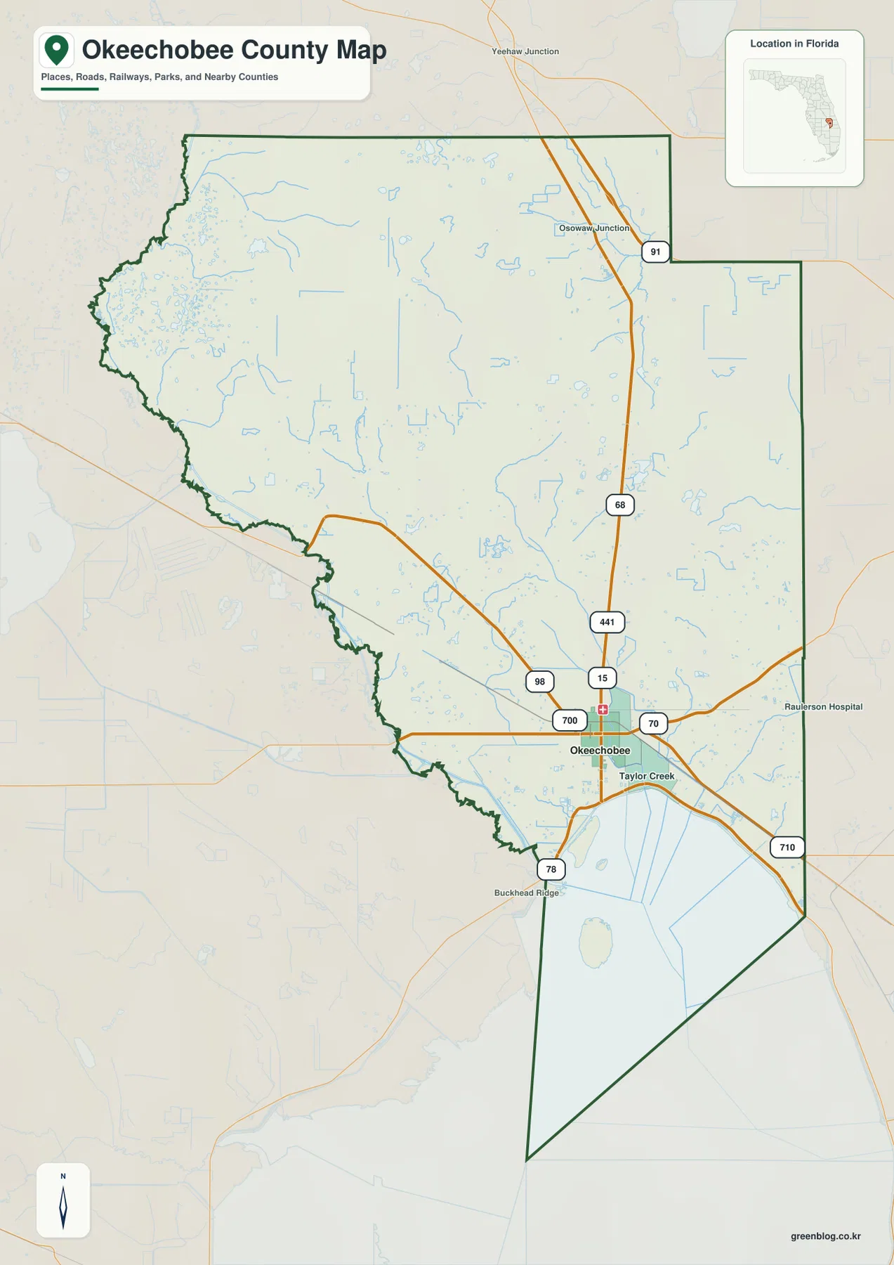
The map also shows a distinctive county-boundary section extending into Lake Okeechobee. That line should not be confused with a dike, shoreline road, or boating route; it is an administrative boundary. Lake access is controlled by actual roads, ramps, locks, dikes, and water-management facilities, so the county outline is best used for jurisdiction and orientation. This distinction is especially important around a large engineered and managed lake where several kinds of lines can appear close together.
Why Okeechobee is the only ranked major city on the city map
The city map ranks only one major incorporated city: Okeechobee. That does not mean the rest of the county is empty. Taylor Creek and other named communities lie outside the city boundary, while ranches and rural homes extend across the wider county. The city index is therefore showing municipal status rather than every populated place. This is a useful distinction because a general map can display many community labels even when the county contains only one incorporated municipality.
Okeechobee’s position explains its importance. SR 70 runs east and west through the city, US 441 reaches it from the northeast, and US 98 approaches from the northwest. SR 710 heads southeast toward Indiantown and connections farther toward the Atlantic side of Florida, while SR 78 provides another route around the northwestern lake area. With no Interstate running through Okeechobee County, these U.S. and state routes carry most of the longer-distance road movement into and out of the county.
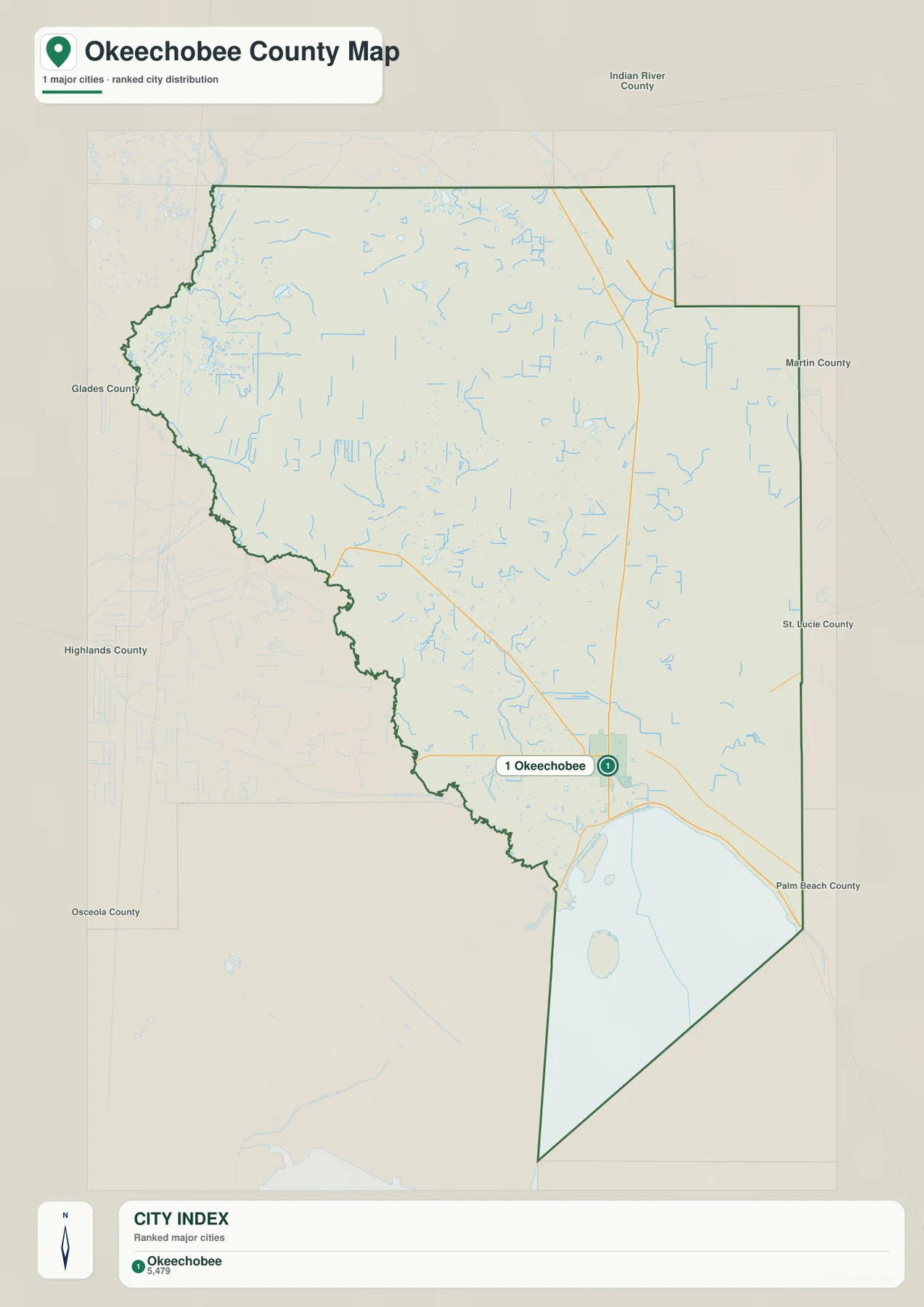
The surrounding county labels add useful context. Martin and St. Lucie counties lie to the east, Indian River County is toward the northeast, and Glades and Highlands counties are to the west. Okeechobee County has no Atlantic or Gulf coastline, so road trips to Florida’s coast necessarily pass through neighboring counties. The city’s southern location also reflects its close relationship with the lake and the road corridors that approach the lake’s northern shore.
From the Kissimmee River to Lake Okeechobee
The water map is dominated by the Kissimmee River along the western side of the county. The river trends south toward Lake Okeechobee, with smaller bays, creeks, sloughs, and drainage features spread across the surrounding lowlands. Oak Creek and Pitman Bay appear in the western half, while Lemkin Creek and Eagle Bay are labeled closer to the lake. Reading these names together shows that the lake is the receiving water for a much broader interior drainage area rather than an isolated body of water at the county edge.
Other named waterways are scattered across the central and eastern county. Taylor Creek runs toward the lake near the main settlement area, Sandy Gully lies farther inland, Gomez Creek appears on the east side, and Fort Drum Creek extends through the northeast. Nubbin Slough approaches the lake from the southeast side of the county, while Jernigans Pond provides an example of the smaller standing-water features shown on the map. These labels make the water map much more useful than a simple lake outline.
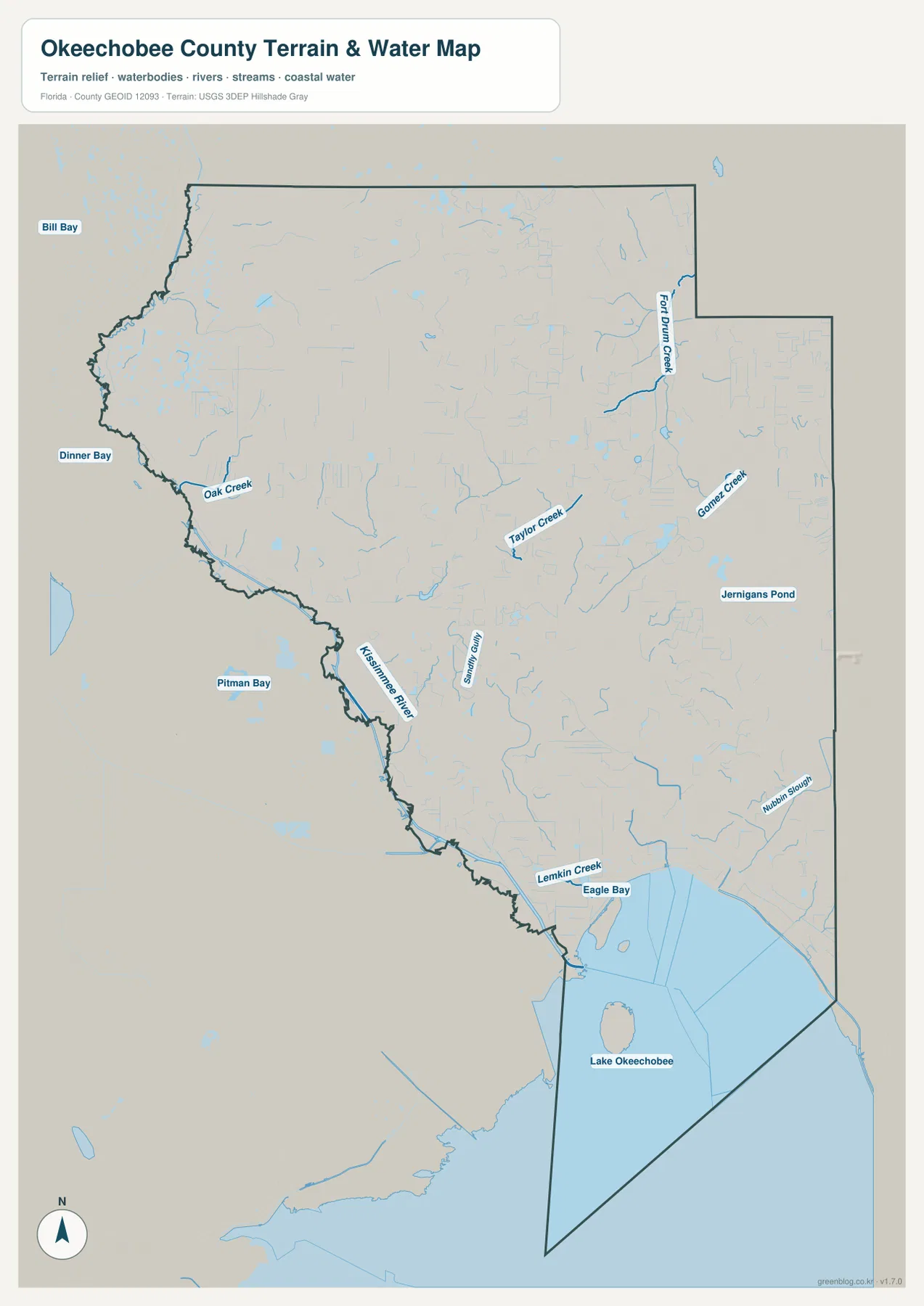
The blue lines should be read as water features, not as guaranteed boating routes. Some are narrow creeks, sloughs, drainage channels, or wetland features whose conditions can change with water levels and management. For driving, the county road map remains the better tool; for understanding the landscape, the water map adds the missing explanation for the broad low-lying areas and the irregular western side of the county. Using both together prevents roads and waterways from being mistaken for the same kind of connection.
Taylor Creek, the north shore, and a common map-reading confusion
Taylor Creek is useful as a reference because the name applies both to a waterway and to a populated area next to the City of Okeechobee. On a general map, the settlement can look like part of the same continuous urban area, but it is not the same incorporated city. On the water map, Taylor Creek refers to the channel that runs toward Lake Okeechobee. Keeping the community name and the waterway name separate avoids one of the most common sources of confusion when comparing the three maps.
The same caution applies to the north shore itself. Roads, dikes, canals, locks, and administrative boundaries can all occur close together around Lake Okeechobee, but this page is not a navigation or water-control operations map. It is best for geographic orientation: Okeechobee lies just north of the lake, Taylor Creek fills the area between the city and lake-access zone, and the Kissimmee River approaches from farther west. Current lock operations, boating access, and water levels should always be checked with the responsible agencies.
Which map to use first for roads, cities, or water
Start with the county map when the question is about direction: where Okeechobee sits inside the county, which way SR 70 runs, how US 441 approaches from the north, or where SR 710 leaves toward the southeast. Use the city map when you want the municipal pattern without extra detail; its single ranked city quickly communicates how different Okeechobee County is from more urban Florida counties. Switch to the water map when the Kissimmee River, Taylor Creek, Fort Drum Creek, Eagle Bay, or the lake shore itself is the subject.
For classroom work or regional comparison, the three maps are strongest when read in sequence. The county map establishes the boundary and roads, the city map shows how concentrated the incorporated settlement is, and the water map explains the broad wetland and drainage setting around that settlement. Together they show a county where the largest concentration of roads and population sits beside one of Florida’s most important lakes, while much of the northern and western interior remains rural and closely tied to water and ranchland.
Frequently Asked Questions
Is all of Lake Okeechobee inside Okeechobee County?
No. Okeechobee County borders and includes part of the lake area on the north side, but Lake Okeechobee also adjoins other counties. The shared name can be misleading, so the county boundary and the full lake outline should be read as separate features.
Why does the city map rank only Okeechobee?
The city index ranks incorporated major cities, and Okeechobee is the county’s only incorporated municipality. Other populated places, including Taylor Creek and rural communities, still exist and can appear on general maps even though they are not ranked as separate incorporated cities.
Which map best shows how the Kissimmee River connects with Lake Okeechobee?
The water map is the clearest choice because it places the Kissimmee River beside smaller features such as Oak Creek, Taylor Creek, Fort Drum Creek, Lemkin Creek, Eagle Bay, and the lake itself. The county map is better for road and boundary context, but the water map gives more detail about the drainage network.
Map File Information
The ZIP below contains the Okeechobee County general map, city map, and water map as high-resolution A3 JPG files.
- Included Files: county map JPG, city map JPG, water map JPG
Related Maps
- Arcadia Roads and Peace River | DeSoto County Florida Map
- Baker County Florida Map
- Between the Aucilla and Withlacoochee: Madison County Florida Map
Sources and References
- U.S. Census Bureau QuickFacts for Okeechobee County – county statistics and administrative reference.
- Okeechobee County official website – county profile and local information.
- South Florida Water Management District: Lake Okeechobee – lake management and water-resource background.
- South Florida Water Management District: Kissimmee River – river and restoration reference.
- Florida Department of Transportation state map – major road and transportation reference.
Green Map creates custom-edited map images using open geographic data sources such as geoBoundaries, Natural Earth, OpenStreetMap, and government open data.
These maps are edited visual materials, not raw data files, and are provided for education, documents, presentations, and graphic reference.