Orange County Florida Map readers often arrive looking for Orlando, but the county extends far beyond Orlando’s city limits. Orange County includes Orlando, Apopka, Ocoee, Winter Garden, Winter Park, Maitland, several smaller municipalities, and large unincorporated areas. Its western side is crowded with lakes and established cities, while the eastern side opens into lower-density wetlands and tributaries near the upper St. Johns River system. This page uses a county map, a city map, and a water map to show those differences clearly, and the download box below provides a ZIP with three high-resolution A3 JPG maps.
The county is easiest to understand when Orlando is treated as one reference point rather than as the whole county. Lake Apopka defines much of the western side, the southwestern corner includes Windermere, Bay Lake, Lake Buena Vista, and major resort areas, and the far eastern section around Christmas has fewer city labels and a much more open landscape. Major toll roads and expressways cross these zones in different directions, so roads, lakes, and waterways are all useful orientation tools.
Table of Contents
Orlando sits inside a county that stretches far east and west
On the county map, Orlando appears slightly west of center. Winter Park and Maitland sit immediately to the north, while Apopka lies farther northwest. Ocoee and Winter Garden are west of Orlando near the southern and eastern sides of Lake Apopka. Farther southwest, Windermere, Bay Lake, and Lake Buena Vista occupy a very different landscape of lakes, resort development, and major highways. These places may all be described casually as part of the Orlando area, but they are not all inside the City of Orlando.
The eastern half of the county looks dramatically different. Christmas appears near the east side, with broad conservation areas, wetlands, and fewer dense road networks around it. The lower number of city labels is meaningful rather than a gap in the map. Orange County’s built-up core is concentrated much more strongly in the central and western portions, while the east contains larger tracts of low-density land and water.
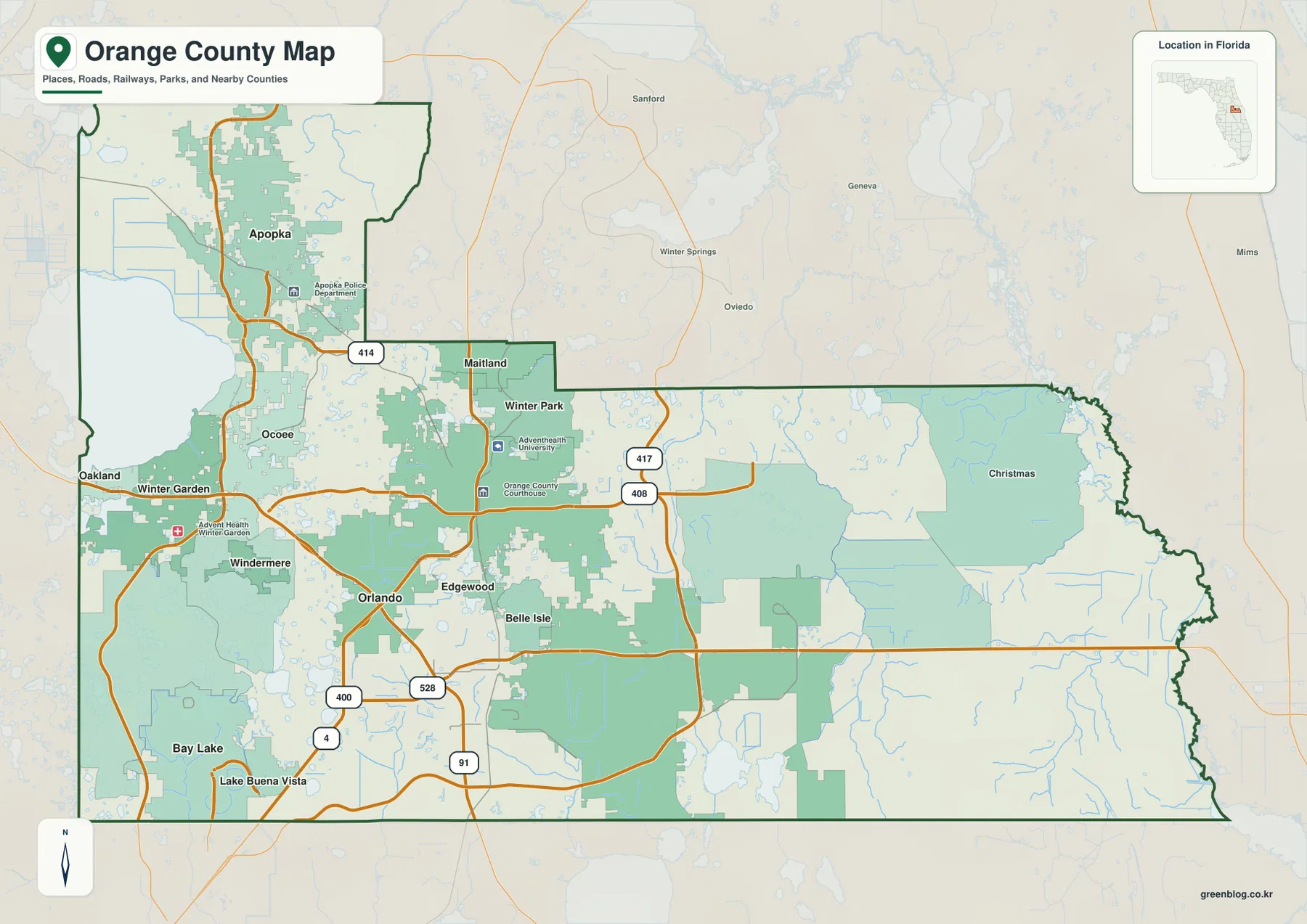
The boundary also helps separate the Orlando metropolitan area from Orange County as an administrative unit. Nearby counties are visible around the edges, including Lake County to the west, Seminole County to the north, Osceola County to the south, and Brevard and Volusia counties farther east and northeast. Development can look continuous across those borders, so following the county line is important when the task involves jurisdiction rather than general metropolitan geography.
A band of major cities wraps around Orlando’s north and west sides
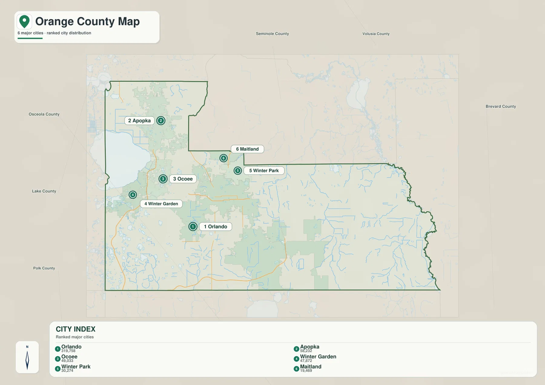
The city map ranks six major municipalities and makes their pattern easy to see. Orlando is the largest and occupies the central urban area. Apopka is the major city farthest to the northwest, Ocoee and Winter Garden form a western pair, and Winter Park and Maitland sit close together north of Orlando. The distribution is strongly weighted toward the central and western county rather than the eastern wetlands.
Winter Park and Maitland can look like a continuous extension of Orlando on a regional street map, yet each is a separate municipality. The same is true of Ocoee and Winter Garden on the western side. Apopka is positioned near Lake Apopka and the northern county, giving it a different relationship to the urban core. Seeing all six cities in one ranked map makes those distinctions easier to grasp than reading a list of municipal names.
The southwestern corner needs a slightly different reading. Bay Lake and Lake Buena Vista are incorporated municipalities, while well-known places such as Horizon West and many other communities are unincorporated. Windermere sits among the Butler lakes, and extensive growth continues west and south of the older city. For addresses, planning, or school material, it is useful to separate municipal boundaries from place names that are widely used even when they are not cities.
I-4, the beltways, and airport routes organize everyday travel
Interstate 4 is the clearest transportation reference on the map. It runs diagonally through the urban core and continues southwest toward the major resort area. SR 408 crosses central Orlando from east to west, while SR 417 makes a broad loop around the eastern and southern sides. SR 429 serves the western growth corridor near Winter Garden, and SR 528 connects the airport side of the county with the southwest.
Orlando International Airport is southeast of downtown rather than directly beside the central business district. That makes SR 528 and SR 417 especially important when orienting the airport relative to downtown and the resort corridor. Travelers heading toward Apopka, Ocoee, or Winter Garden are more likely to use the western and northwestern network. Looking at these road relationships before estimating distance prevents many of the mistakes that come from treating the entire county as one continuous city.
Water changes from large western lakes to eastern rivers and wetlands
Lake Apopka is the dominant water feature on the western side of the water map. South and east of it, smaller lakes are scattered densely through the built-up part of the county. Bay Lake and several resort-area water bodies appear farther southwest. These lakes interrupt otherwise direct road patterns and help explain why neighborhoods and municipal boundaries often bend around shorelines instead of following a simple grid.
Farther east, the map shifts from lake-dominated scenery to river and wetland drainage. The Econlockhatchee River, St. Johns River, Tootoosahatchee Creek, Jim Creek, and numerous smaller channels become much more prominent. The eastern county therefore has a different physical structure from the urbanized west: fewer dense city streets, more open land, and a network of waterways that feed toward the upper St. Johns system.
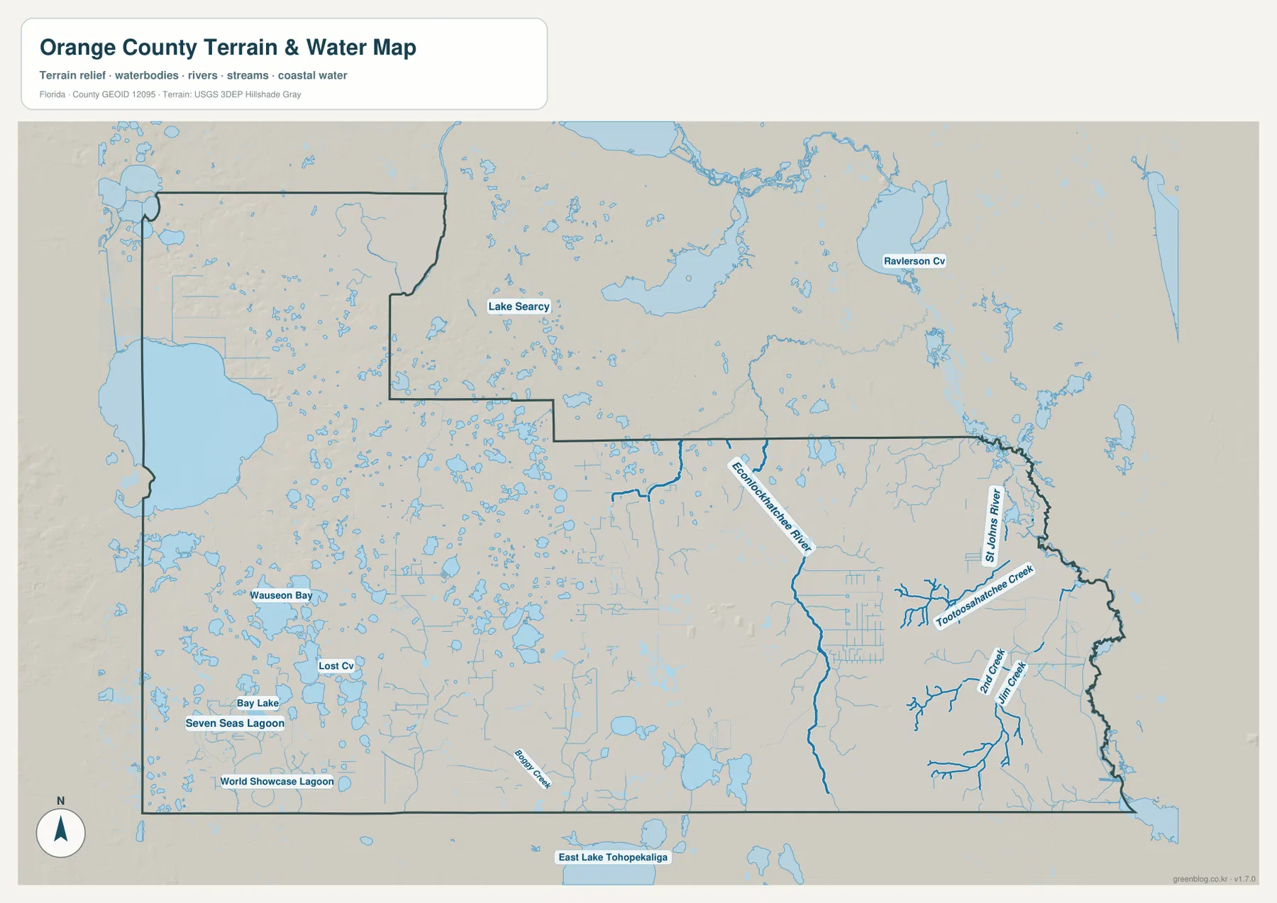
Lake Apopka also illustrates why county boundaries matter when reading natural features. The lake sits along the Orange–Lake county area rather than entirely inside Orange County. Following the shoreline without checking the boundary can lead a reader into a neighboring county without an obvious visual change. The same principle applies in the east, where river and wetland systems continue beyond administrative lines.
Practical ways to compare places across Orange County
For jurisdiction questions, start by checking whether a place is inside Orlando or elsewhere in Orange County. Pine Hills, Dr. Phillips, University, Hunters Creek, Horizon West, and other familiar names can refer to unincorporated communities rather than independent municipalities. An Orlando mailing address also does not always mean the location is within Orlando city limits. The county and city maps are therefore useful together when explaining addresses, local government, or service areas.
For travel orientation, use I-4 to connect downtown with the northeastern urban corridor and the southwest resort area, then add SR 528 and SR 417 for the airport side. Lake Apopka and SR 429 are strong western reference points. As the map moves east, the city network becomes less dense while rivers and wetlands become more important. That sequence gives Orange County a clear internal structure even before smaller streets and neighborhoods are added.
Frequently Asked Questions
Are Orange County and the City of Orlando the same area?
No. Orlando is one city inside Orange County. The county also includes municipalities such as Apopka, Ocoee, Winter Garden, Winter Park, and Maitland, along with extensive unincorporated territory. An Orlando mailing address can also be outside Orlando’s municipal limits, so city and county boundaries should be checked separately.
Is all of Lake Apopka inside Orange County?
No. Lake Apopka lies along the Orange County and Lake County area, so the lake is not contained entirely within Orange County. The county boundary should be checked when following roads or communities around the shoreline.
Why does eastern Orange County have fewer city labels?
The eastern side contains more low-density land, wetlands, conservation areas, and tributaries connected with the upper St. Johns River system. Places such as Christmas appear on the map, but the landscape is much less urbanized than central and western Orange County.
Map File Information
The ZIP below contains the Orange County general map, city map, and water map as high-resolution A3 JPG files.
- Included Files: county map JPG, city map JPG, water map JPG
Related Maps
- Arcadia Roads and Peace River | DeSoto County Florida Map
- Baker County Florida Map
- Between the Aucilla and Withlacoochee: Madison County Florida Map
Sources and References
- U.S. Census Bureau QuickFacts for Orange County – county population and general statistics.
- Orange County municipality directory – incorporated municipalities in the county.
- Orange County Horizon West information – southwest unincorporated growth area.
- St. Johns River Water Management District Lake Apopka North Shore – Lake Apopka and restored wetland context.
- Florida Department of Transportation official map resources – major road reference.
Green Map creates custom-edited map images using open geographic data sources such as geoBoundaries, Natural Earth, OpenStreetMap, and government open data.
These maps are edited visual materials, not raw data files, and are provided for education, documents, presentations, and graphic reference.