Dawson County sits on the eastern side of the Llano Estacado, where the broad High Plains begin to break toward lower, more deeply drained land. Lamesa is the county seat and the clearest point of reference because US 87 and US 180 meet there, while the eastern side of the county carries a much denser network of creeks and gullies. This page pairs those features with county, city, water, and elevation maps, and the download box provides all four maps as high-resolution A3 JPG files in one ZIP archive.
Table of Contents
Lamesa at the County’s Main Road Crossroads
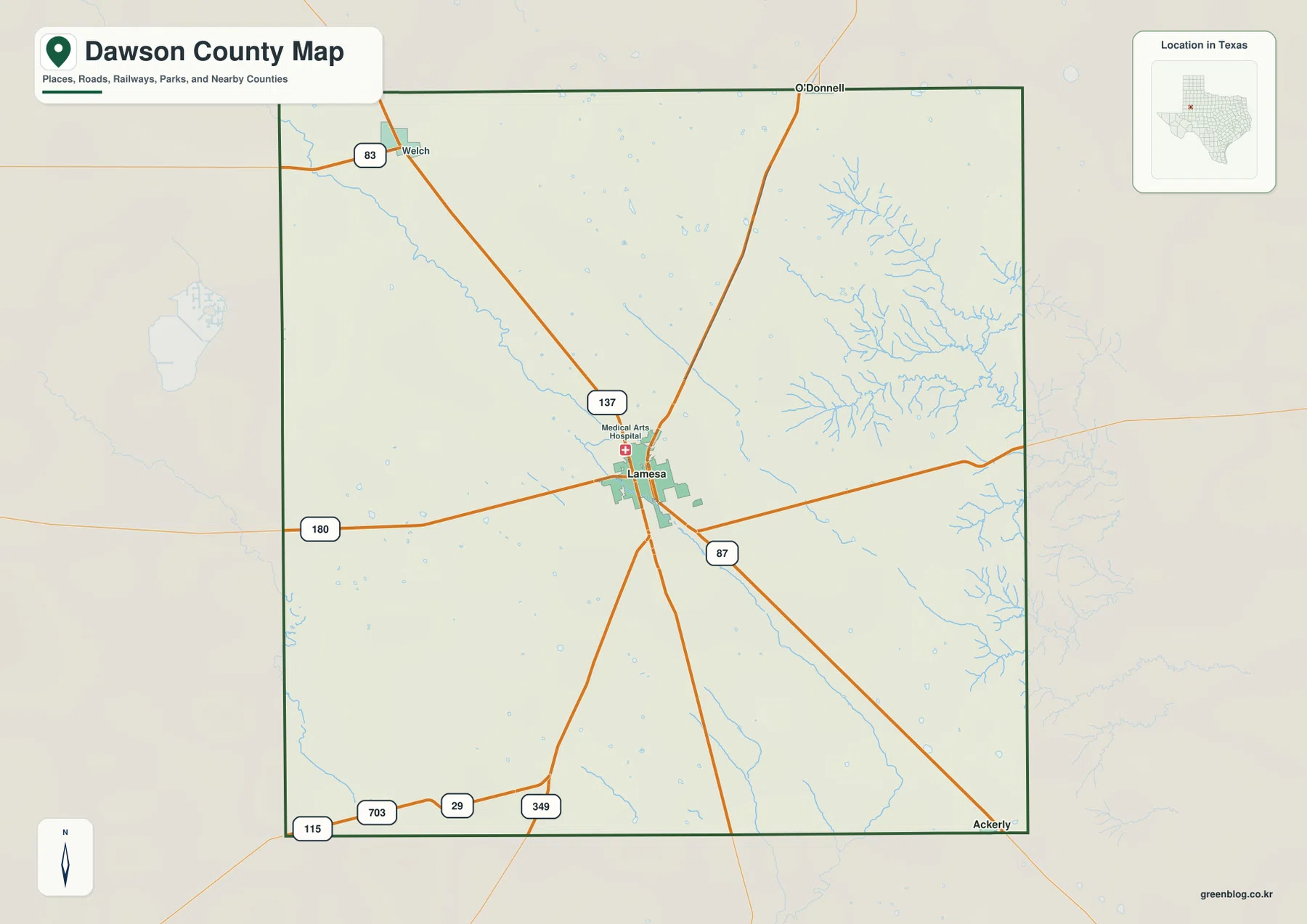
The general county map makes Lamesa the natural starting point. US 87 runs north and south through the city, and US 180 crosses it from west to east. State Highway 137 approaches from the northwest, while State Highway 349 continues south from the Lamesa area. Together, these routes create a clear hub-and-spoke pattern in the middle of a county where most of the surrounding land remains open and lightly settled.
Several smaller places help orient the outer parts of the map. Welch appears toward the northwest, O’Donnell lies at the northern edge, and Ackerly is marked near the southeastern corner. These places are useful not because they form a continuous urban belt, but because they show where the main highways and local roads leave the Lamesa-centered interior and connect with neighboring counties.
A Compact Urban Core in a Broad Rural County
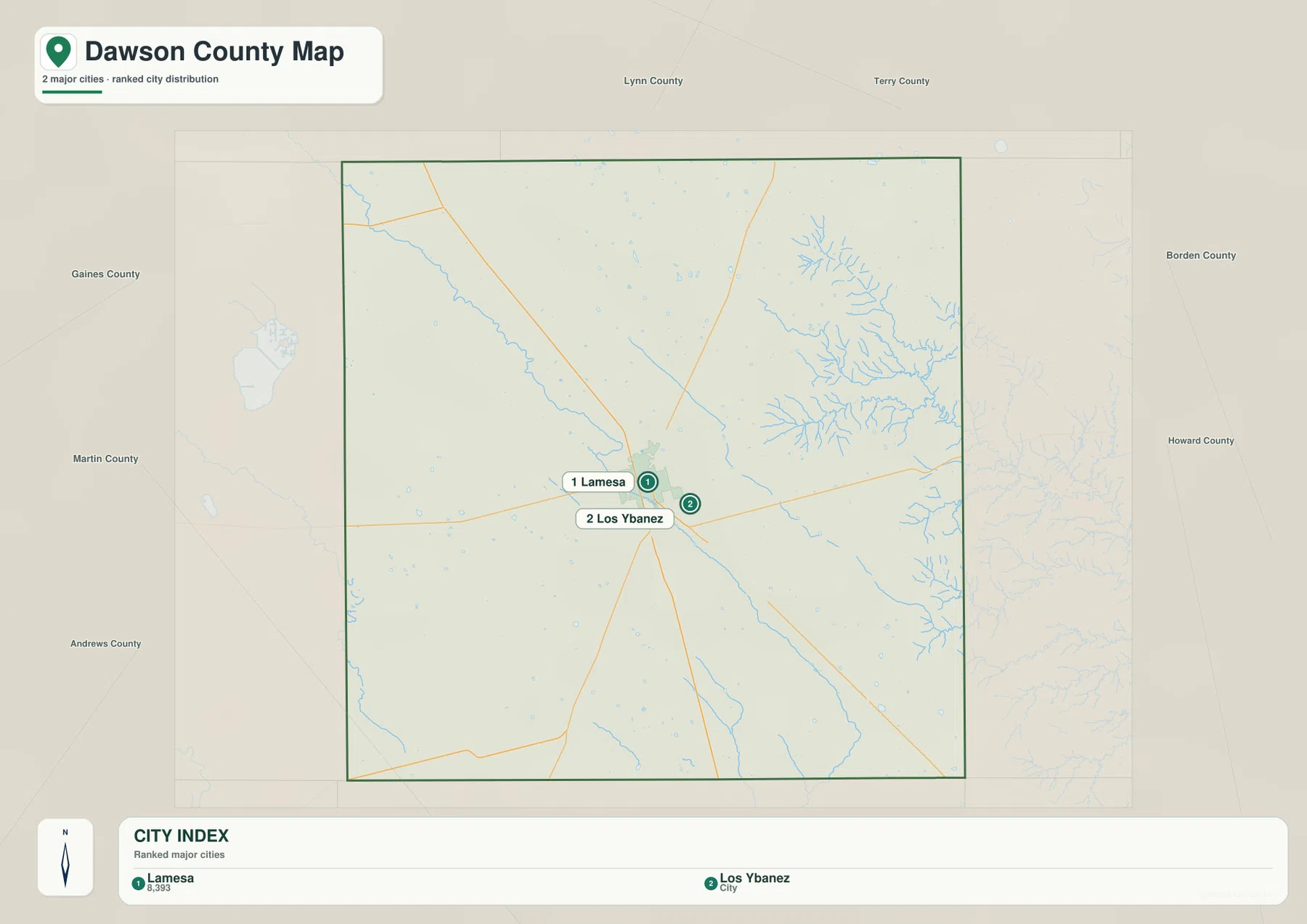
The city map emphasizes Lamesa and nearby Los Ybanez. Their close spacing contrasts with the much larger stretches of rural land around them, so the settlement pattern is easy to understand at a glance: one principal service center, a very small incorporated neighbor, and scattered communities and farms farther out. This is a different visual pattern from metropolitan Texas counties where several large cities merge into a continuous built-up area.
The surrounding county labels also place Dawson County within the South Plains. Lynn and Terry are to the north and northwest, Gaines and Andrews lie to the west and southwest, Martin is to the south, and Borden and Howard are on the eastern side. Reading the city map together with the road map makes it easier to see which directions link Lamesa to the larger regional network.
Why the Creek Network Becomes Denser in the East
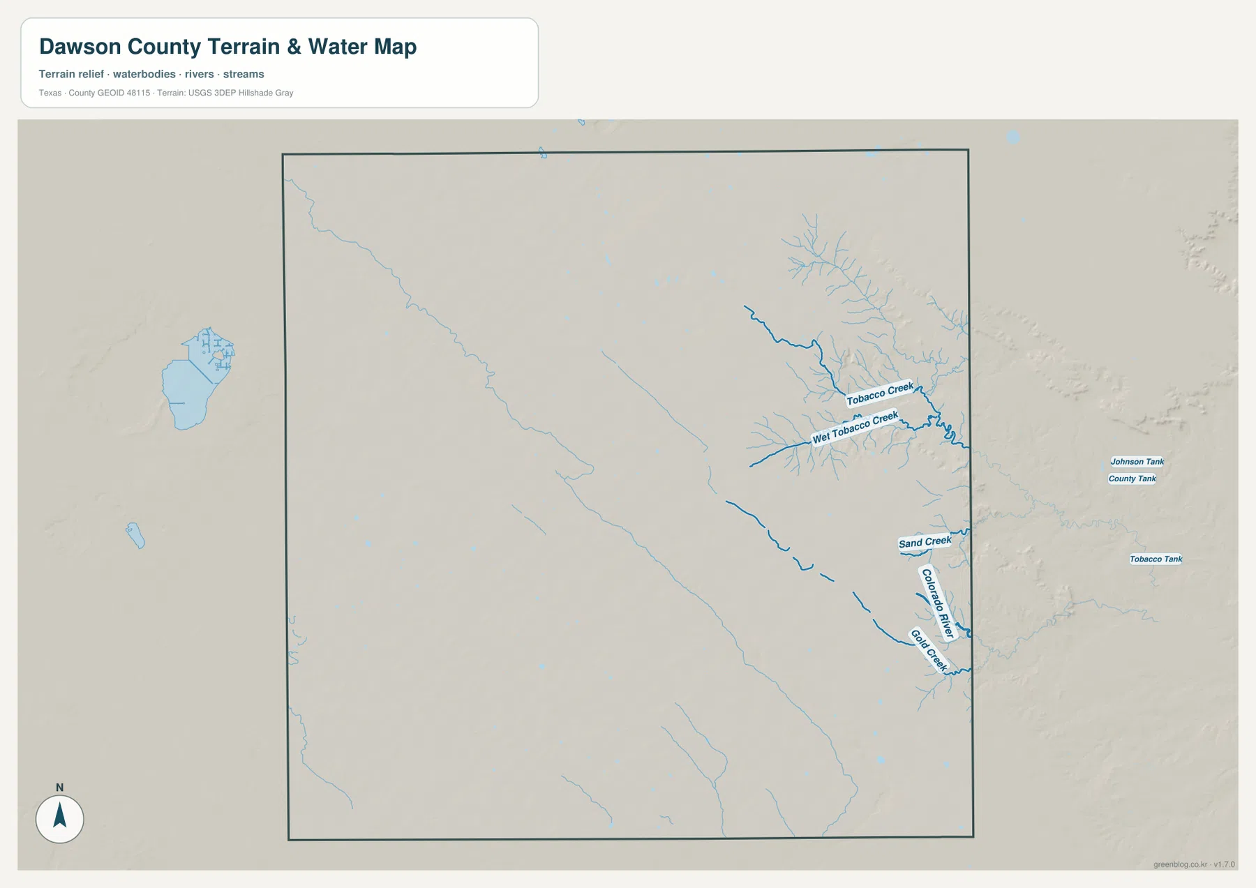
The water map changes the picture substantially. Much of the western and central county has relatively few mapped channels, while the eastern side contains a branching network of drainage lines. Tobacco Creek and Wet Tobacco Creek are labeled in the northeast and east, with Sand Creek and Gold Creek farther south. The Colorado River label appears near the eastern edge as the drainage becomes more concentrated.
This is not a county dominated by one broad river running straight through the center. Instead, the map shows smaller tributaries gathering where the surface begins to fall away from the High Plains. The contrast is especially strong when the water map is compared with the elevation map: the places with more dissected terrain are also the places where blue drainage lines multiply.
From the Higher Western Plain to the Lower Eastern Breaks
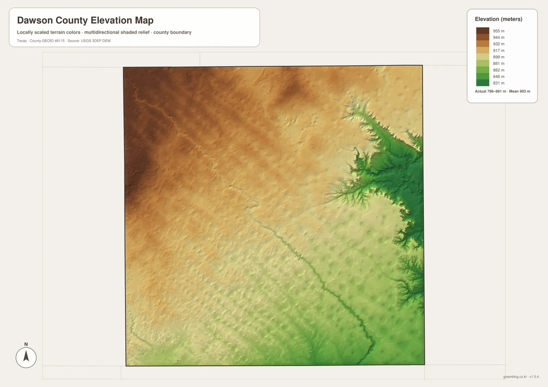
Dawson County lies on the eastern edge of the Llano Estacado, and the elevation map makes that regional setting visible. The western and northwestern parts of the county are generally higher, while the surface trends lower toward the east. The map reports an actual elevation range of roughly 788 to 981 meters, with the broad interior remaining relatively gentle compared with the more incised eastern margin.
The most noticeable relief is not a single mountain or ridge. It is the gradual transition from the smooth High Plains surface into terrain cut by tributary valleys. That distinction helps explain why the road pattern can look so regular around Lamesa and across western farmland, yet the eastern edge appears more irregular when water and shaded relief are added.
What Becomes Clear When the Maps Are Compared
Each map answers a different practical question, but their value is greatest when they are read together. The county map establishes the road network and the locations of Lamesa, Welch, O’Donnell, and Ackerly. The city map simplifies the settlement picture around Lamesa and Los Ybanez. The water map then draws attention away from the urban center and toward the branching eastern drainages, while the elevation map explains why those channels are concentrated there.
For a classroom worksheet or a county comparison, the general map is the most convenient base because it combines roads and place names. The city map is cleaner when the goal is to show the principal incorporated places. The water map is better for creek names and drainage, and the elevation map is the strongest choice for explaining the transition from the Llano Estacado surface to the lower eastern breaks.
Lamesa and the County’s High Plains Setting
Lamesa became the Dawson County seat in 1905 and grew as a local center for farming, transportation, and later oil-related activity. Its role is still easy to recognize on the map because several important highways meet there and most urban development is concentrated nearby. The Handbook of Texas also places the county on the eastern edge of the Llano Estacado, a description that matches the strong west-to-east terrain change visible in the elevation image.
That setting gives Dawson County a useful combination of features for map study. The central and western portions show the broad, open character associated with the South Plains, while the east is marked by more numerous channels and broken terrain. The maps therefore show more than a set of boundaries: they explain why Lamesa occupies a convenient central position and why the county’s physical character changes so noticeably toward the east.
Frequently Asked Questions
What is the easiest place to start when reading a Dawson County map?
Start with Lamesa. US 87 and US 180 meet there, so one city gives you both the central location and the county’s two most obvious highway directions. From there, it is easy to locate Welch, O’Donnell, Ackerly, and the surrounding county lines.
Why are there more mapped creeks on the eastern side?
The elevation map shows the land dropping and becoming more dissected toward the east. Tobacco Creek, Wet Tobacco Creek, Sand Creek, and nearby tributaries follow that lower terrain, so the drainage network appears much denser than it does across the smoother western plain.
Which maps are included in the downloadable ZIP?
The archive includes the county, city, water, and elevation maps as separate high-resolution A3 JPG files. They are larger than the WebP previews used in the article and are intended for printing or reuse in reference materials.
Sources and Reference Data
- Handbook of Texas – Dawson County: county history, physical setting, and the eastern edge of the Llano Estacado.
- Handbook of Texas – Lamesa: county-seat history and major highway connections.
- Texas Department of Transportation – Departmental Map: official reference for the state-maintained road network.
- USGS National Hydrography: official hydrography and drainage reference.
- USGS 3D Elevation Program: official elevation data source.
Map File Information
The ZIP contains the four Dawson County maps shown on this page as high-resolution A3 JPG files. Use the larger files for printing, presentations, classroom activities, or side-by-side county comparisons.
- Included Files: county map, city map, water map, elevation map
Related Maps
- Terry County Texas map
- Scurry County Texas map
- Andrews County Texas map
- Yoakum County Texas map
- Sterling County Texas map
Green Map creates custom-edited map images using open geographic data sources such as geoBoundaries, Natural Earth, OpenStreetMap, and government open data.
These maps are edited visual materials, not raw data files, and are provided for education, documents, presentations, and graphic reference.