Download the high-resolution Shelby County JPG maps in one ZIP from the file box below. The archive contains the general county, city-connections, terrain-and-water, and elevation views at 2572×3638 pixels each. On the page, the maps show Shelbyville near the county center, U.S. 421 crossing from northwest to southeast, Route 9 running north–south, and Routes 44 and 244 spreading east. The physical maps add Big Blue River, Little Blue River, Brandywine Creek, Sugar Creek, Flatrock River, and a 177–287 meter relief surface that rises broadly toward the east.
This Shelby County Indiana Map set is easiest to use by keeping Shelbyville fixed as the main reference point. Fountaintown and Morristown lie to the north and northeast, Fairland, Boggstown, and London occupy the west and northwest, and Waldron is southeast of the county seat. Flat Rock appears near the southern edge. With those places in mind, the road, water, and elevation views fit together without requiring the reader to memorize every local label.
The terrain shows a broad east–west difference. The elevation legend reports an actual county range of about 177 to 287 meters and a mean of 240 meters. Much of the west and central-south is lower and greener, while orange and brown high ground becomes more common toward the east and northeast. River and creek valleys interrupt that high ground, so the county is not a single smooth slope.
Table of Contents
U.S. 421 and Route 9 create a practical road frame around Shelbyville
Shelbyville is the clearest starting point on the general county map. U.S. 421 enters from the northwest near the London side, crosses the Shelbyville area, and continues southeast toward Waldron. Route 9 follows a more direct north–south line from the Fountaintown side through Shelbyville toward Flat Rock. The two roads give the county an immediate directional framework before the eastbound routes are added.
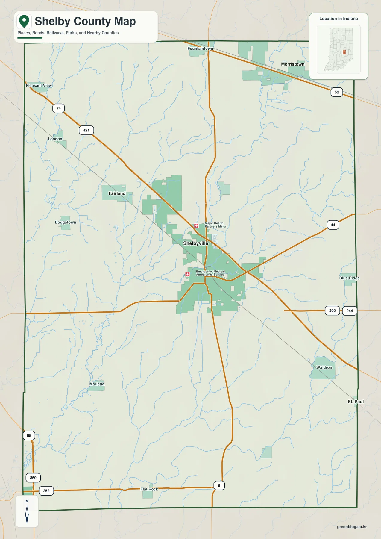
East of Shelbyville, Route 44 heads toward the northeast while Route 244 crosses farther south. They do not form one continuous eastbound corridor, so the eastern half is better read as several routes leaving the Shelbyville area at different levels. Waldron sits in the southeast and is easy to relate to U.S. 421, while the road marked 200 provides another interior reference.
The northwest has a different structure. London lies near the outer part of the county, while Fairland and Boggstown are farther inward. U.S. 421 provides the strongest long route through this side before reaching Shelbyville. Pleasant View appears farther northwest and helps define the corner of the mapped county.
South of Shelbyville, Route 9 continues toward Flat Rock. The southwestern edge also includes the route labels 65, 850, and 252, which sit away from the central road network. The general map is useful for direction and relative placement, but current construction or traffic restrictions should be checked with a current transportation source.
Morristown and Fairland show how Shelbyville opens toward two northern directions
The city-connections map reduces the comparison to Shelbyville, Morristown, and Fairland. Morristown is shown about 11 miles to the northeast of Shelbyville, while Fairland is about 5 miles to the northwest. The map identifies these as direct distances, so they are straight-line measurements rather than road mileage. Actual driving distances can be longer depending on the route.
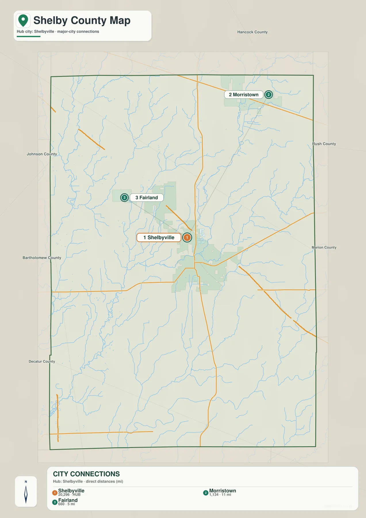
Morristown lies close to the northeastern side of the county and fits naturally with the Route 52 direction. Fairland is much closer to Shelbyville and is easier to connect with the U.S. 421 side. The two places make a useful pair because both are north of Shelbyville, yet they occupy opposite northern directions and are separated by very different distances.
Small numeric values also appear beneath the place names, but the supplied package does not identify the statistical year or provide a separate source for those numbers. This article therefore does not treat them as current official population. A current U.S. Census product should be used when up-to-date population is needed. The verified value of the city map here is its direction and stated straight-line distance.
Labels for Hancock, Rush, Johnson, Bartholomew, and Decatur counties provide useful surrounding context. Morristown sits closer to the northeastern boundary, while Fairland is in the northwestern interior. Together they give a quick sense of Shelby County’s northern width from the Shelbyville hub.
Big Blue River and Brandywine Creek divide the eastern and central valleys
Big Blue River is the strongest named water feature on the eastern side of the terrain-and-water map. It enters from the northeast, bends through the eastern interior, and continues southward. Little Blue River follows a separate course farther east and southeast. The similar names do not indicate one simple continuous line; the two waterways occupy different parts of the county.
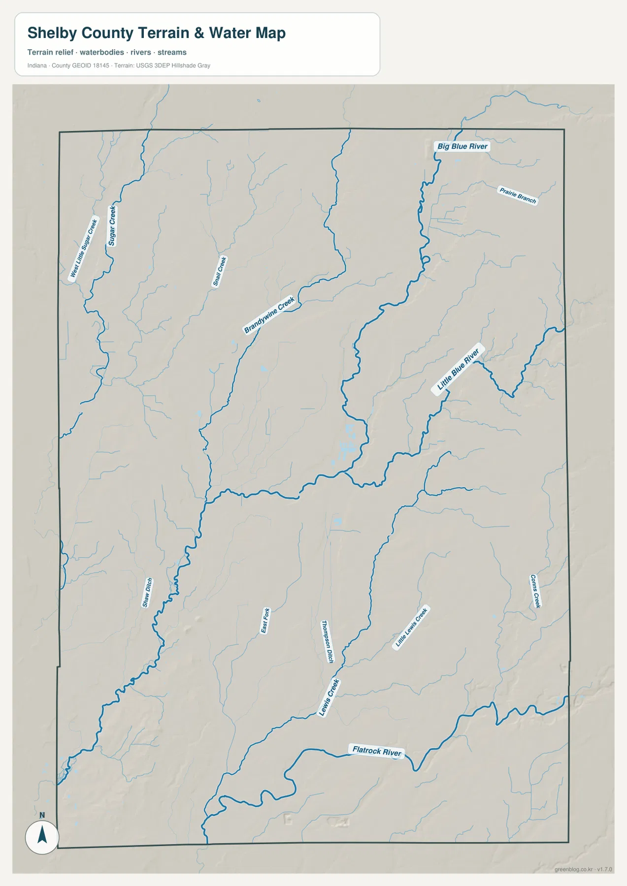
Brandywine Creek provides the clearest central water reference. It comes down from the northern interior, passes through the Shelbyville area, and continues south. Sugar Creek occupies a different valley in the northwest. The two creeks therefore organize separate parts of the county rather than forming a pair of parallel channels.
Flatrock River is the main southern water feature. Lewis Creek and Little Lewis Creek are labeled farther north, while Conns Creek appears to the east. A practical way to read the map is to find the eastern Blue River system, central Brandywine Creek, northwestern Sugar Creek, and southern Flatrock River first, then place the smaller tributaries around them.
This terrain-and-water map is a county-scale reference, not a flood map, parcel map, legal water-boundary product, drainage-engineering plan, or navigation chart. It is appropriate for locating named rivers and creeks and comparing where they lie relative to Shelbyville and the county boundary. Current flood conditions or site-specific water decisions require dedicated agency data.
The 177–287 meter relief range rises broadly toward the east
The elevation legend gives Shelby County an actual range of about 177 to 287 meters and a mean of 240 meters. Green represents lower terrain within the county-scale display, shifting through yellow and orange to brown at higher elevations. The broadest pattern is lower ground across much of the west and central-south and higher ground across the east and northeast.
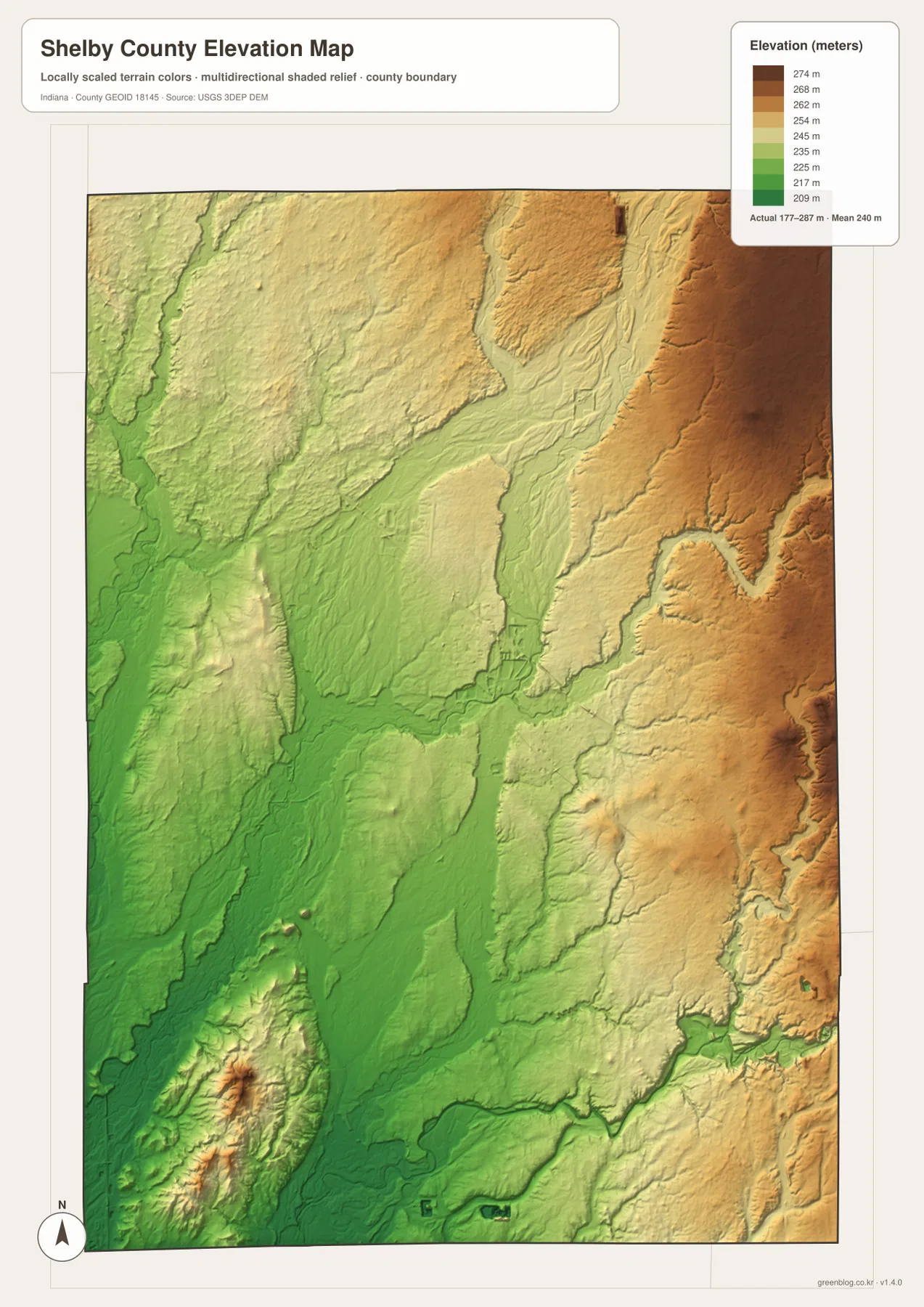
The eastern high ground is cut by lower valleys. Big Blue River and Little Blue River align with long green or light-yellow corridors that bend through the orange-brown surface. In the northeast, those low river routes sit close to higher ridges, producing noticeable local elevation changes over short distances.
The west is lower overall but still contains relief. Sugar Creek and smaller tributaries occupy low valleys, with gentle ridges between them. A few isolated higher areas appear within the broader green surface. Shelby County is therefore better understood as lower western ground and higher eastern ground divided by multiple stream valleys, not as a perfectly smooth incline.
The elevation map is designed for county-level comparison rather than survey-grade measurement. It should not be used to assign an exact elevation to a house, road point, field, or construction site. The range and mean are useful regional reference values, but precise site elevations require source data or professional survey measurements.
Keep Shelbyville fixed while switching between roads, rivers, and relief
For ordinary place finding, begin with the general county map and locate Shelbyville, U.S. 421, and Route 9. When the question is only where Morristown and Fairland lie relative to the county seat, the city-connections map provides a cleaner comparison. Moving back to the road view after that makes the surrounding routes easier to understand.
For water features, use the terrain-and-water map to locate Big Blue River, Brandywine Creek, Sugar Creek, and Flatrock River. Then open the elevation view and find the same areas. The river and creek corridors generally occupy lower terrain, which makes the relationship between drainage and relief especially clear on the eastern side.
The WebP previews are optimized for browser viewing. The downloadable ZIP contains the original high-resolution JPG versions of the general county map, city-connections map, terrain-and-water map, and elevation map. Each file is a portrait image measuring 2572 by 3638 pixels, making the originals better for enlarging small road and creek labels or preparing an A3 print.
A simple comparison routine is to keep Shelbyville fixed as the reference point. Find U.S. 421 and Route 9 on the general map, place Morristown and Fairland on the city view, separate Brandywine Creek from the eastern Blue River system on the water map, and then compare the low western greens with the higher eastern browns on the elevation image. Repeating the same central location makes the differences among the maps easy to understand.
Frequently Asked Questions
Are the 11 miles to Morristown and 5 miles to Fairland driving distances?
No. The city-connections map identifies them as direct distances. Morristown is about 11 straight-line miles northeast of Shelbyville, while Fairland is about 5 straight-line miles northwest. Actual road mileage can be longer depending on the route used.
Which waterways are the easiest landmarks on the Shelby County map?
Big Blue River and Little Blue River are the strongest eastern references. Brandywine Creek crosses the central interior, Sugar Creek is useful in the northwest, and Flatrock River provides the main southern reference. Finding those larger waterways first makes the smaller tributaries easier to place.
Where does the elevation map show the clearest countywide contrast?
The broadest contrast is between lower green terrain in the west and central-south and higher orange-brown ground across the east and northeast. The legend reports an actual range of about 177–287 meters and a mean of 240 meters. River valleys still cut lower corridors through the higher eastern side.
Map File Information
Download the high-resolution JPG originals for the Shelby County general map, city-connections map, terrain-and-water map, and elevation map in one ZIP. Use the originals when small road or creek labels need to remain clear or when preparing an A3 print.
- Printable Size: 2572×3638 px each
Related Maps
Sources and References
The road, settlement, water, and elevation descriptions above are based on the supplied Shelby County maps and asset information. The official resources below are useful when source boundary, hydrography, or elevation data is needed.
- U.S. Census Bureau TIGER/Line Shapefiles – official county boundary, road, and place reference data
- USGS National Hydrography – official river and stream data information
- USGS 3D Elevation Program – elevation source data and program information
Green Map creates custom-edited map images using open geographic data sources such as geoBoundaries, Natural Earth, OpenStreetMap, and government open data.
These maps are edited visual materials, not raw data files, and are provided for education, documents, presentations, and graphic reference.