Harrison County occupies a hilly part of southern Indiana where the Ohio River forms the broad southern edge and smaller streams cut deep valleys through the interior. You can download the high-resolution JPG ZIP directly from this page when you need larger road labels, waterway names, terrain colors, or printable originals. This Harrison County Indiana Map page begins with Corydon, then follows the county outward toward Palmyra and Milltown in the north and west, Lanesville in the east, Elizabeth in the southeast, and the river communities near the southern boundary.
Corydon is the easiest place to use for orientation. State Road 135 runs north-south through the area, while State Road 62 extends east toward Lanesville. To the north, New Salisbury and Ramsey lead toward Palmyra; to the northwest, Milltown and Depauw sit near a much more irregular boundary. The southern half becomes more spread out, with New Middletown and Elizabeth to the southeast and Laconia, Mauckport, and New Amsterdam closer to the Ohio River side of the county.
The water and elevation views make Harrison County look much more rugged than the road map alone suggests. Blue River bends through the western side, Indian Creek and the Big/Little Indian Creek system divide the center, and Buck Creek drains part of the south. The Ohio River is the largest water feature and marks the low southern edge. On the elevation map, those valleys appear green against higher yellow and brown ridges, with an actual county elevation range of about 118 to 296 meters and a mean of 210 meters.
Table of Contents
Corydon ties together the main road directions across Harrison County
The general county map is easiest to read from Corydon outward. State Road 135 passes through Corydon and continues north toward New Salisbury, Ramsey, and Palmyra. South of Corydon it heads toward the Laconia and Mauckport side of the county. State Road 62 branches east and eventually reaches the Lanesville corridor, while the western side is connected by roads that lead toward the irregular Blue River boundary.
North of Corydon, the map places New Salisbury near the 135 corridor and Ramsey farther west, with Palmyra at the top of the county. Crandall lies southeast of New Salisbury and close to State Road 64, giving the northeast-central section a useful secondary reference point. The road network is not a perfect grid: several routes bend around the hills and creek valleys, which becomes much more obvious when the road map is compared with the terrain views.
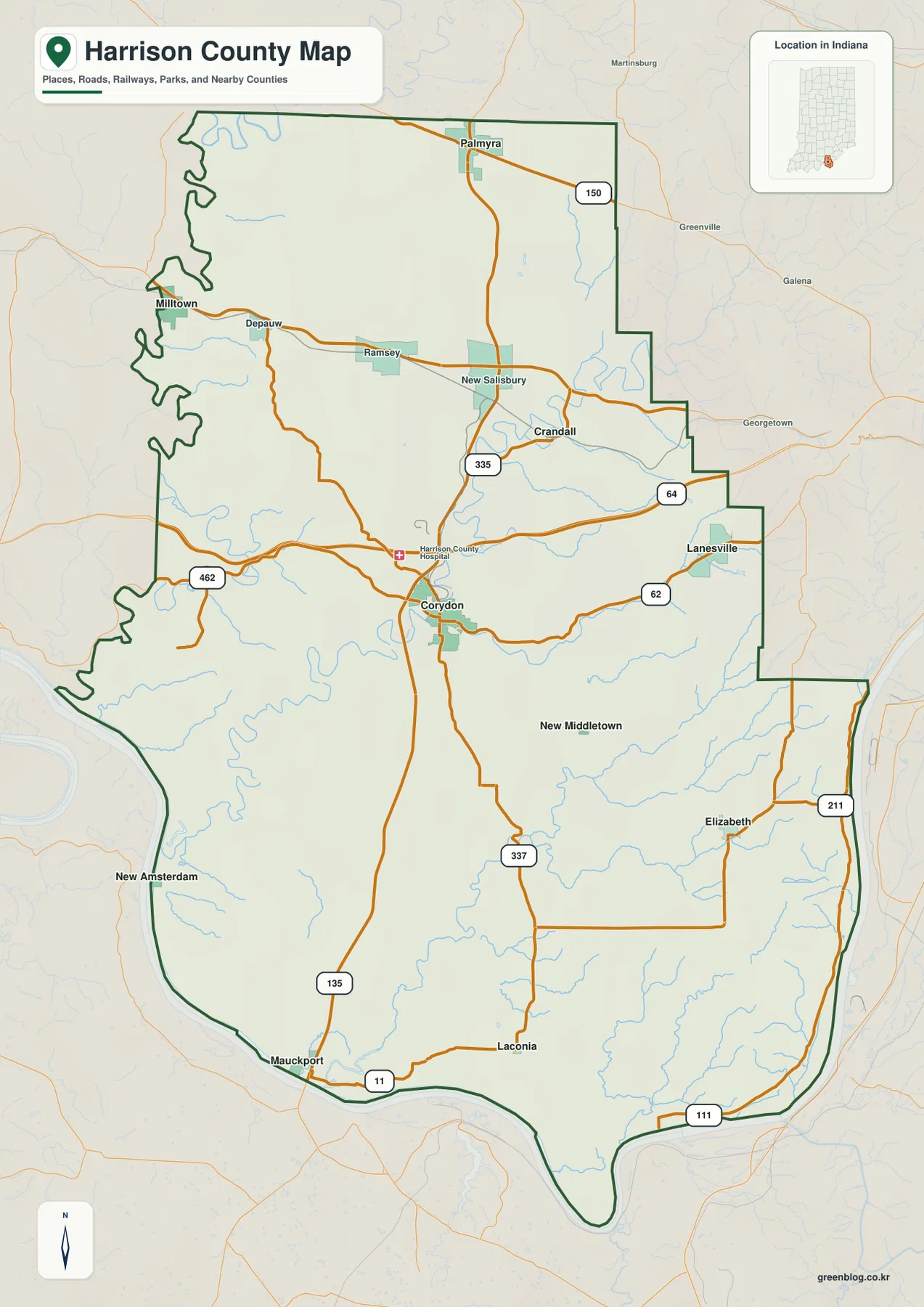
The western side looks different from the east because the county boundary is much more winding. Milltown sits close to that irregular northwest edge, while Depauw is farther east on the way toward Ramsey. New Amsterdam appears near the Ohio River in the southwest, and Mauckport lies farther south where State Road 135 approaches the river. Those places are easier to remember when the county outline is treated as part of the map rather than as a simple frame.
The southeast is organized around a different set of routes. New Middletown lies below Corydon and east of the main 135 corridor, while Elizabeth is farther southeast. State Road 337 extends south from the Corydon area, and State Road 211 is labeled near the far eastern side. Lanesville sits farther north along State Road 62. These routes provide enough reference points to move between the scattered communities without treating the county as if it had one continuous built-up corridor.
Corydon also has a wider historical role in the county. Harrison County’s official website identifies Corydon as Indiana’s first state capital. That fact does not explain the road network by itself, but it gives useful context for why Corydon remains such a familiar reference point when the county is described. On the supplied map, important roads and the hospital label also make Corydon easy to locate before moving to the less densely labeled areas.
The city index shows six highlighted places spread across very different parts of the county
The city index removes much of the road detail and highlights six places with values printed on the supplied image. Corydon is first at 3,157, followed by Palmyra at 1,215, Lanesville at 944, Milltown at 763, Crandall at 233, and Elizabeth at 168. These figures should be treated as the values printed on the map, not as a guarantee of the newest official population estimates. Their strongest use here is to show the relative scale and wide geographic separation of the selected communities.
| Rank | Place | Value printed on map | Position |
|---|---|---|---|
| 1 | Corydon | 3,157 | North of center |
| 2 | Palmyra | 1,215 | North |
| 3 | Lanesville | 944 | East |
| 4 | Milltown | 763 | Northwest |
| 5 | Crandall | 233 | Northeast-central |
| 6 | Elizabeth | 168 | Southeast |
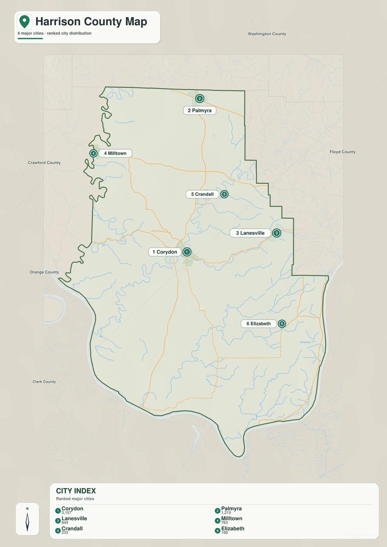
Unlike a county with several large places clustered around one metro edge, Harrison County’s highlighted communities are spread across the map. Palmyra is far north of Corydon, Lanesville is close to the eastern side, and Milltown occupies the irregular northwest. Elizabeth is well to the southeast. That spacing makes the city index useful for learning direction and relative position rather than simply reading a ranking from top to bottom.
The general county map includes additional names that do not appear in the six-place index, such as Ramsey, New Salisbury, Depauw, New Middletown, Laconia, Mauckport, and New Amsterdam. Their absence from the index does not mean those places are unimportant or missing from the county. The index is selective. When you need smaller communities or road connections, return to the general map; when you want a quick comparison of the six highlighted places, the index is cleaner.
The layout also helps when switching to the water map. Milltown is a useful northwest reference near the Blue River side, Corydon is close to the central Indian Creek system, and Elizabeth is closer to the southeastern creek network. Matching these city positions to the drainage map is a straightforward way to keep the many stream names from becoming a disconnected list.
Blue River and the Indian Creek system cut deep valleys above the Ohio River
The terrain-and-water map makes the western side of Harrison County immediately recognizable. Blue River bends repeatedly near the western boundary and is surrounded by short tributaries that descend from the nearby hills. Farther east, Indian Creek forms another long, winding valley through the central-western part of the county. These two waterways are separated by ridges, so the relief around them is much more broken than the road map suggests.
North of the center, Big Indian Creek follows a broad meandering course, with Raccoon Branch labeled to its east. Little Indian Creek extends across the central-eastern side and joins a network of smaller tributaries. Because Indian Creek, Big Indian Creek, and Little Indian Creek have similar names, it helps to place them in order: Indian Creek is more central-west, Big Indian Creek is north-central, and Little Indian Creek is farther east.
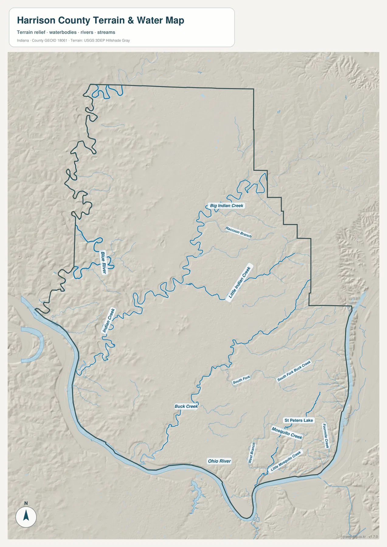
Farther south, Buck Creek becomes an important interior reference. To the east, South Fork and South Fork Buck Creek cross the rolling terrain. The southeast contains smaller named features including St Peters Lake, Mosquito Creek, Little Mosquito Creek, and Fountain Creek. No single lake dominates the map; the landscape is defined much more by branching streams and narrow valleys.
The Ohio River is the largest water feature and forms the sweeping southern boundary. Its width and long bend are easy to distinguish from every interior creek. Indiana DNR’s O’Bannon Woods State Park information also notes that Blue River flows through the state park and forest area near the Ohio River, providing a useful real-world reference for the two large waterways visible on the supplied map.
This water view is a location reference, not a flood, navigation, legal-boundary, or water-quality product. A blue line or river polygon does not tell you the current water level, flood probability, navigability, or property ownership. Those questions require current agency data. Here, the map is best used to see how the streams divide the hill country and where the larger valleys sit relative to Corydon and the county boundary.
The 118–296 m elevation map separates river valleys from high ridges
The elevation map gives an actual county range of about 118 to 296 meters and a mean of 210 meters. Dark greens mark lower ground, while yellow, tan, and brown show higher terrain. The strongest pattern is not a simple north-to-south slope. Instead, high ridges occupy much of the northwest and eastern sides while low, winding valleys follow Blue River, Indian Creek, and the Ohio River. That contrast gives Harrison County a much more dissected appearance than many flatter parts of Indiana.
The northwest is especially rugged. Short brown ridges are repeatedly split by green creek valleys, producing a dense pattern of rises and cuts. Moving toward the north-central area, the map becomes somewhat broader and smoother, although the ground remains elevated. Comparing this area with the general road map helps explain why several roads bend rather than following a perfectly straight grid through the county.
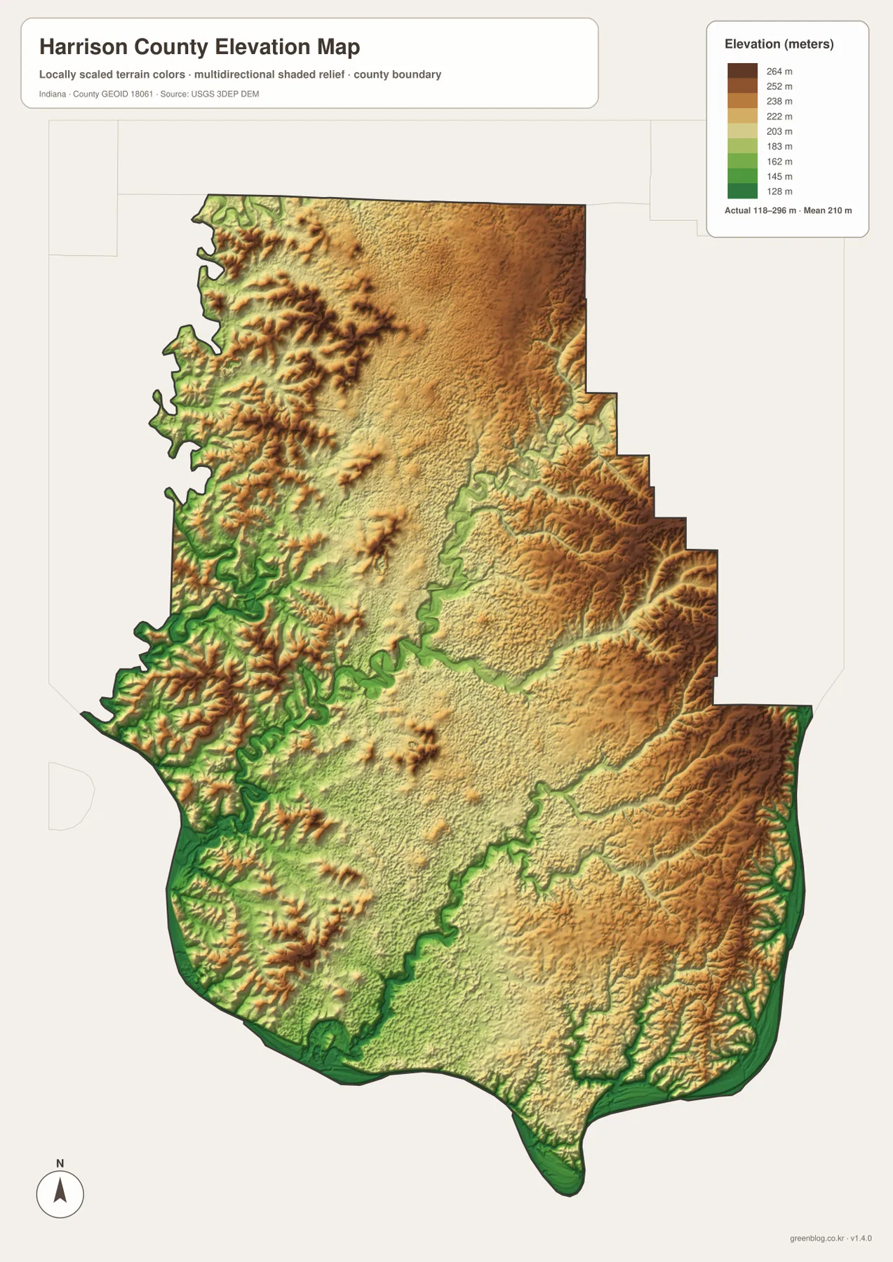
Indian Creek creates one of the clearest low corridors in the middle of the map. Its green meanders are surrounded by terrain that rises quickly into yellow and tan ridges. Little Indian Creek and the eastern tributaries produce a similar, though narrower, effect. These valley shapes are easier to identify after reading the stream names on the water map, which is why the two views work particularly well side by side.
The southern edge is low along the Ohio River, but southern Harrison County is not one broad flat plain. Moving inland from the river, hills rise again and smaller creek valleys cut through them. The east side also contains long elevated ridges with narrow green drainage cuts. A description such as “low south, high north” would therefore miss much of the local relief visible on the map.
The 118–296 m range is a county-scale reference, not survey-grade elevation. A property, road grade, drainage design, or construction project needs source elevation data or professional surveying. The USGS 3D Elevation Program is a more appropriate starting point for precise terrain data. The supplied image is designed for broad comparison: where the ridges are high, where the river valleys are low, and how strongly the terrain changes over short distances.
Start with Corydon for orientation, then use the stream and elevation maps for the hills
For a first look at Harrison County, the general map is the best starting point because it combines the county outline, roads, and the widest set of place names. Find Corydon, follow State Road 135 north toward Palmyra and south toward Mauckport, and then use State Road 62 to locate Lanesville to the east. Milltown in the northwest and Elizabeth in the southeast give the map outer reference points.
Use the city index when the question is about the six highlighted places rather than every settlement. Corydon has the largest printed value, but the more important map-reading lesson is the wide spacing between Palmyra, Milltown, Lanesville, and Elizabeth. The index is intentionally selective, so smaller labeled places still require the general map.
For physical geography, switch to the water map and locate Blue River, Indian Creek, Big Indian Creek, Little Indian Creek, Buck Creek, and the Ohio River. Then open the elevation map and look for the same winding valleys in green. The high brown ridges around those low corridors make the county’s hill country much easier to understand than either image alone.
The web previews are sized for fast page loading and general reading. For fine road labels, smaller creek names, terrain details, or larger-format printing, the original JPG files are more useful. The download archive contains the county/general map, city index map, terrain-and-water map, and elevation map as 2572×3638-pixel JPG originals.
A useful comparison method is to follow the same place through several maps. Find Corydon and the State Road 135 corridor on the general map, move to the water map to locate the nearest Indian Creek valleys, and then check the elevation surface to see the surrounding ridges. Repeat the process with Milltown near the Blue River side or Elizabeth in the southeast. That approach connects settlement, water, and relief without expecting any one map to show everything at once.
Frequently Asked Questions
What is the easiest way to find Corydon on the map?
Look for the State Road 135 and State Road 62 area near the north-central part of the county. State Road 135 continues north toward Ramsey and Palmyra and south toward the Ohio River side, while State Road 62 extends east toward Lanesville. Once Corydon is located, most of the surrounding towns can be placed by direction from that reference point.
Where are Blue River and the Ohio River in Harrison County?
Blue River bends along the western side of the county, while the Ohio River forms the broad southern boundary. Between them, Indian Creek, Big Indian Creek, Little Indian Creek, Buck Creek, and several smaller streams divide the interior hill country. The water map is suitable for location reference but should not be used to determine flood risk, navigation status, or legal water boundaries.
Can the 118–296 m elevation range be used as an exact property elevation?
No. The supplied elevation map gives a county-wide range of about 118 to 296 meters, with a mean of 210 meters. It is intended to compare broad high and low areas, such as the ridges and the Blue River, Indian Creek, and Ohio River valleys. Exact property or engineering elevations require source elevation data or a professional survey.
Map File Information
This ZIP contains the Harrison County general map, city index map, terrain-and-water map, and elevation map as high-resolution JPG originals for enlarged viewing and printing.
- File Type: ZIP containing four 2572×3638px JPG files
Related Maps
Sources and References
The article is based primarily on the supplied Harrison County map set and asset manifest. The following official and public sources provide additional county context and underlying boundary, water, and elevation references.
- Harrison County, Indiana – official county information and Corydon context
- Indiana DNR O’Bannon Woods State Park – official information about Blue River and the Ohio River area
- U.S. Census Bureau TIGER/Line Shapefiles – boundary and geographic reference data
- USGS National Hydrography – hydrography reference data
- USGS 3D Elevation Program – elevation source data
Green Map creates custom-edited map images using open geographic data sources such as geoBoundaries, Natural Earth, OpenStreetMap, and government open data.
These maps are edited visual materials, not raw data files, and are provided for education, documents, presentations, and graphic reference.