Delta County is a small Northeast Texas county whose shape makes much more sense once the Sulphur River system is placed beside the roads and towns. Cooper, the county seat, sits near the middle of the wider western half, while Pecan Gap marks the far-western side of the settlement pattern. The maps on this page show the county boundary, the main mapped communities, Cooper Lake and the local stream network, and the change in elevation from the higher west to the lower eastern river corridor. The same maps are also available as high-resolution A3 JPG files in a downloadable ZIP.
Rather than looking like a regular rectangle, Delta County narrows steadily toward the east. Its northern and southern edges follow river country, creating a jagged outline that ends in a thin point where the Sulphur drainage converges. The western side is broader and contains Cooper, Pecan Gap, more local roads, and a dense web of small creeks. Keeping that west-to-east contrast in mind helps explain nearly everything else on the four supplied maps, from road placement to the direction of drainage and the colors on the elevation map.
Table of Contents
Cooper, the Road Junction, and Delta County’s Unusual Outline
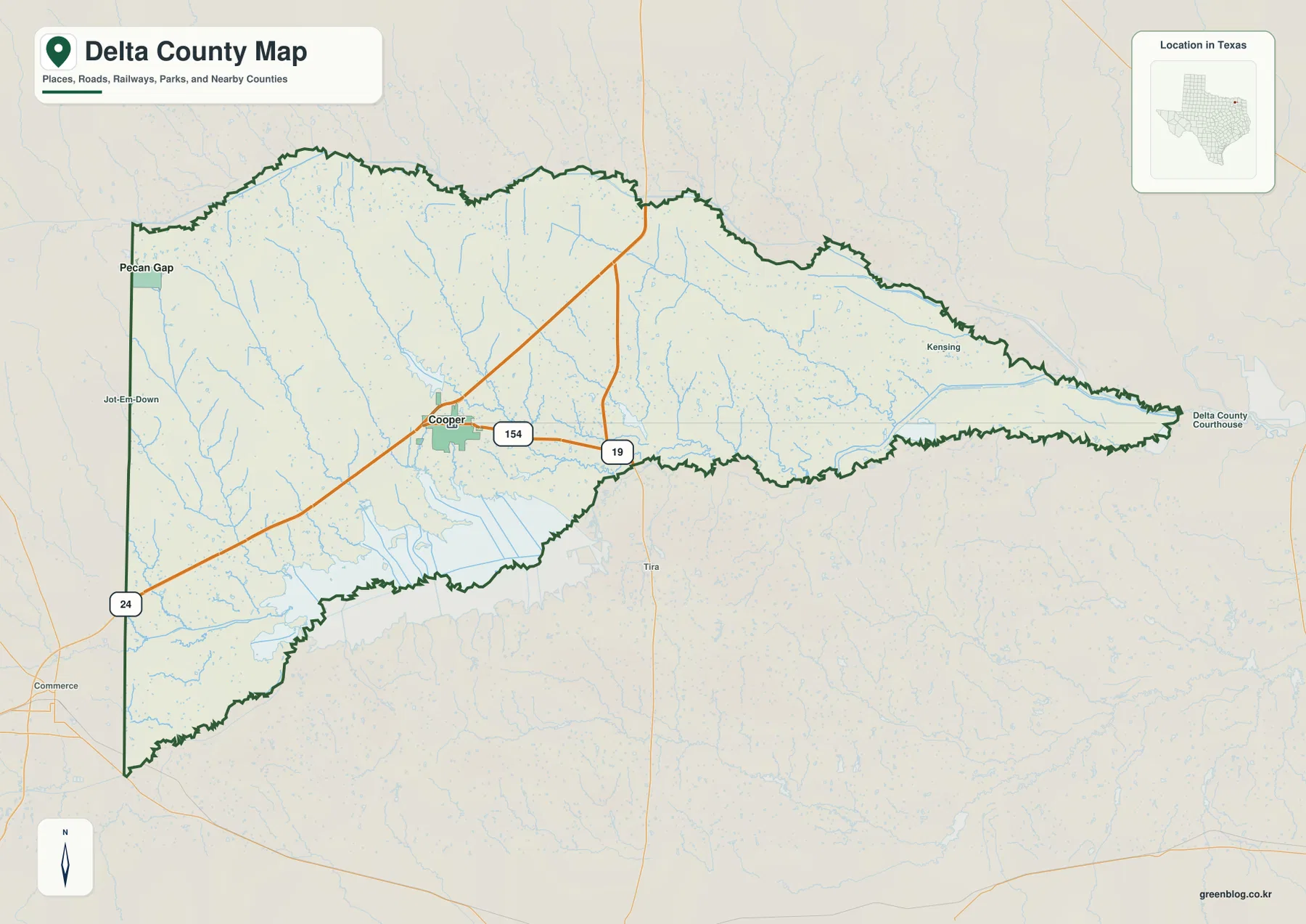
The general county map places Cooper close to the center of Delta County’s wider section. The Texas State Historical Association identifies Cooper as the county seat and notes that State Highways 24 and 154 meet there. On the map, Highway 24 approaches from the Commerce side in the southwest, passes through Cooper, and continues toward the northeast. Highway 154 extends east from Cooper, while Highway 19 appears farther east and south, providing another useful reference for travel toward the Cooper Lake and Sulphur Springs area.
The boundary is just as informative as the highways. The western edge is comparatively straight, but the northern and southern edges are deeply irregular because they follow river valleys and drainage terrain. East of Cooper the county becomes dramatically narrower until it reaches a long, pointed end. That geometry means “central Delta County” and “eastern Delta County” look very different on a map: the first has room for towns, roads, and many small tributaries, while the second is essentially a narrow corridor between branches of the Sulphur River system.
A Small Settlement Pattern Anchored by Cooper and Pecan Gap
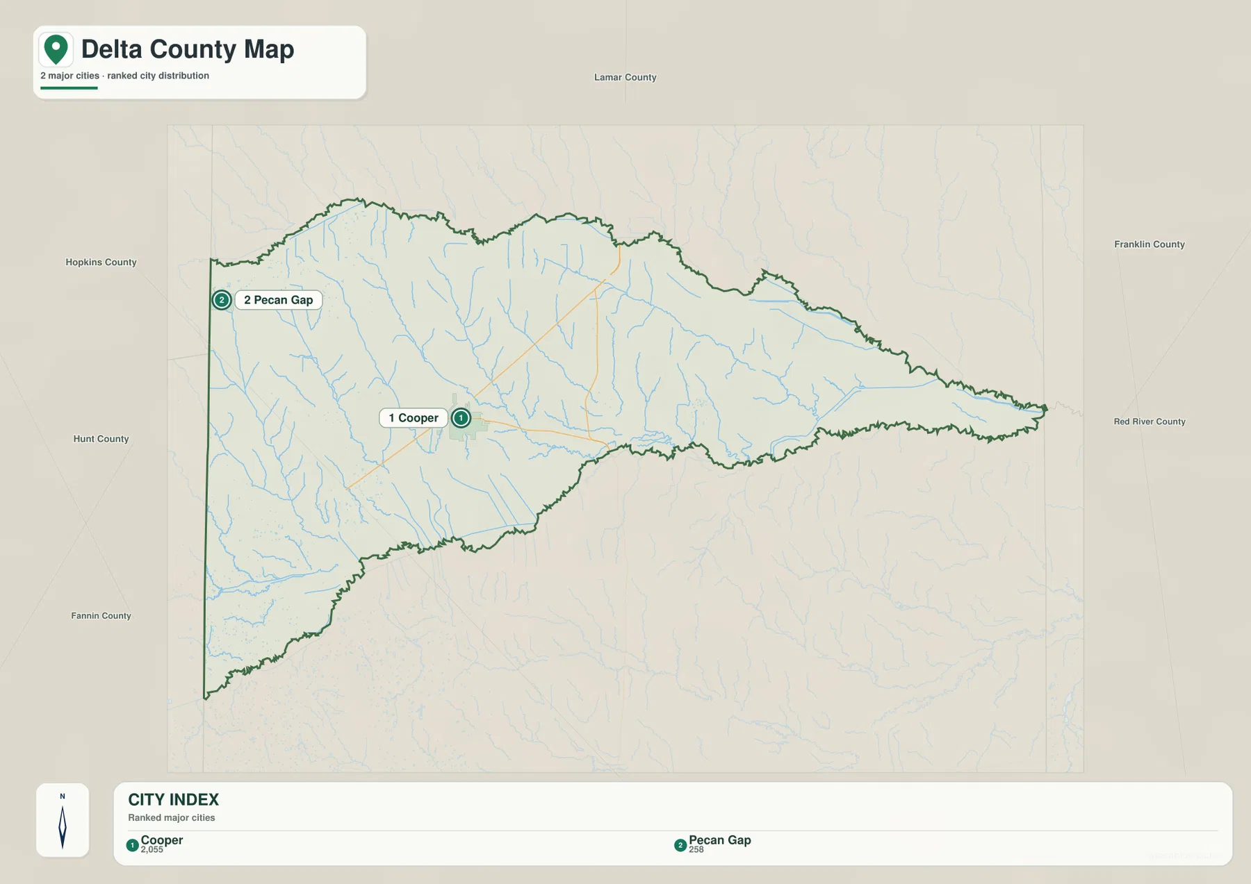
The city map is intentionally simple. It ranks only two major places: Cooper first and Pecan Gap second. Cooper is the clear population and service center, while Pecan Gap lies close to the western county line. The distance between the two labels is filled mostly by rural land, local roads, and creek valleys rather than a continuous urban strip. For readers accustomed to metropolitan county maps, this is an important distinction: Delta County is organized around small communities separated by open countryside.
Pecan Gap is useful as a western reference point, especially when comparing the county with the Fannin and Lamar County sides of the region. Cooper is the better anchor for understanding internal travel because the main highways meet there and the lake lies to the south. The outer neighboring-county labels on the supplied city preview are not all placed in geographically correct directions, so this article does not use those peripheral labels as evidence. The locations of Cooper and Pecan Gap inside Delta County, however, agree with the county map and published geographic sources.
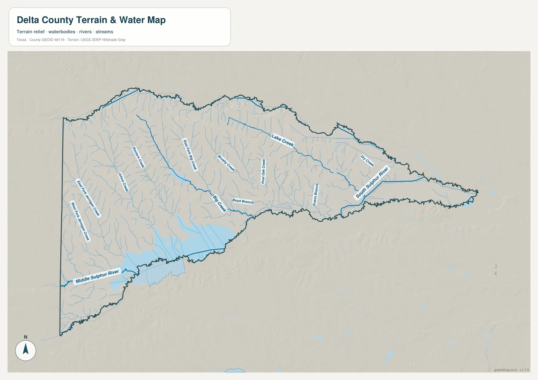
Sulphur River Boundaries, Cooper Lake, and a Dense Creek Network
Water is the defining geographic feature of Delta County. The Texas State Historical Association describes the North Sulphur River along the north, the South Sulphur River along the south, and their meeting waters as the basis of the eastern boundary. The terrain-and-water map focuses more closely on the interior drainage. It labels South Sulphur River in the long eastern section and shows tributaries such as Doctor Creek, Johns Creek, East Fork Big Creek, Rattan Creek, Post Oak Creek, Lake Creek, Dry Creek, and Boyd Branch feeding toward the larger river system.
A broad blue water body occupies part of the south-central edge. This is the northern portion of Jim Chapman Lake, commonly called Cooper Lake. Texas Parks and Wildlife places the reservoir on the Middle and South Forks of the Sulphur River and notes that it extends across Delta and Hopkins counties. That is why the lake should not be treated as an isolated interior feature. It is part of the same drainage system that helps shape the county’s southern side, and the dam, park units, and access roads create a strong geographic connection between the county seat and the lake.
Cooper State Park adds another practical landmark. Its Doctors Creek Unit is on the north side of the lake near Cooper, while the South Sulphur Unit lies on the opposite side. For map readers, the park is a useful example of why the water map and road map should be read together: the reservoir interrupts direct movement, so access follows highways and local roads around the shoreline rather than continuing across the water.
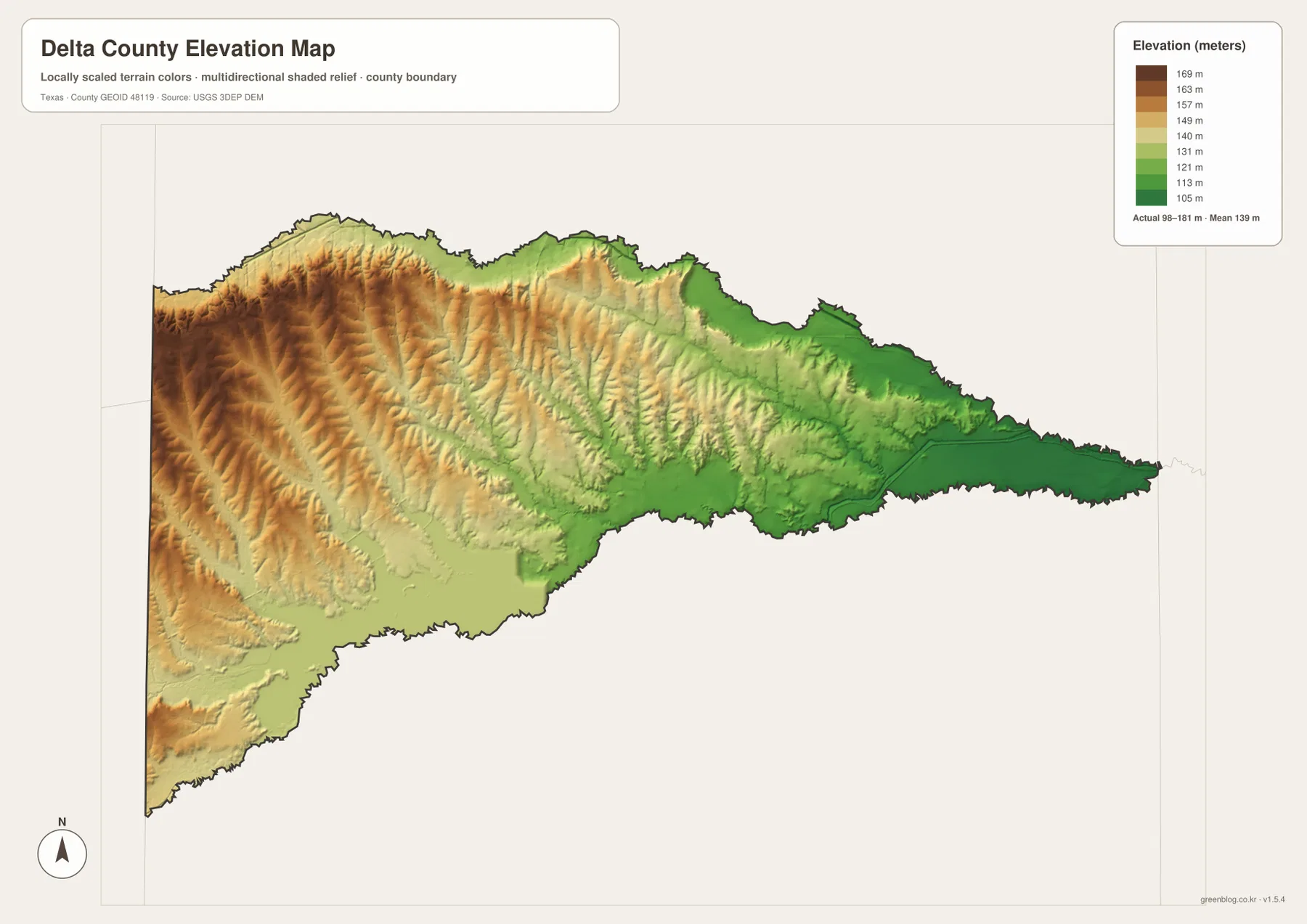
Higher Ground in the West, Lower River Country in the East
The elevation map gives the county a very different appearance from the road map. Its legend shows an actual mapped range of roughly 98 to 181 meters, with a mean near 139 meters. Browns and golds cover much of the west and northwest, indicating the higher parts of the county. Greens become more common toward the center and especially the east, where the narrow county tip follows low river terrain. The contrast is gradual rather than mountainous, but it is strong enough to explain the direction of many tributaries.
Shaded relief in the western half reveals many small ridges and shallow valleys. These features correspond closely with the dense creek network on the water map. Moving east, the terrain becomes lower and visually smoother as drainage converges toward the South Sulphur and the joined Sulphur system. This agrees with the Texas State Historical Association’s description of Delta County as part of the Blackland Prairies with undulating terrain. There are no large mountains here; the useful story is the steady loss of elevation from upland prairie and rolling divides into broad river bottoms.
Which Delta County Map Is Most Useful?
Use the general county map when the main question is where Cooper sits, how Highways 24, 154, and 19 relate to the county, or how the boundary changes from west to east. The city map removes most of that detail and is better for a quick comparison of Cooper and Pecan Gap. The water map is the strongest choice for Cooper Lake, South Sulphur River, Middle Sulphur River, and named creeks. The elevation map is best when the goal is to connect those streams with the higher western ground and lower eastern river bottoms.
For a classroom or local-history exercise, a useful sequence is to mark Cooper first, trace the river-defined edges second, and then compare the water and elevation maps. That sequence reveals why the county has its unusual shape without requiring technical GIS terminology. For park visits or fieldwork around Cooper Lake, combine these maps with current Texas Parks and Wildlife directions because local access roads, park entrances, and travel conditions can change more often than the county’s physical geography.
Frequently Asked Questions
Where is Cooper on the Delta County map?
Cooper is near the center of the county’s wider western half, at the junction of State Highways 24 and 154. It is the easiest starting point for reading the map because Pecan Gap lies to the west and Cooper Lake lies to the south.
Is Cooper Lake entirely inside Delta County?
No. Jim Chapman Lake, commonly called Cooper Lake, spans Delta and Hopkins counties. On the supplied water map, the Delta County portion appears along the south-central edge and connects directly with the larger Sulphur River drainage.
Why does Delta County narrow so sharply toward the east?
The county’s northern and southern sides are strongly tied to the North and South Sulphur river system. As those waterways approach one another, the land between them becomes narrower, producing the long pointed eastern end visible on the county and elevation maps.
Map File Information
The ZIP contains the Delta County general map, city map, terrain-and-water map, and elevation map as high-resolution A3 JPG files. Use the original files when you need a larger print, a classroom handout, or a clean reference image.
- File Type: JPG
Related Maps
- Red River County Texas map
- Titus County Texas map
- Wood County Texas map
- Rains County Texas map
- Rockwall County Texas map
Sources and References
The county-specific descriptions were checked against the supplied map previews and the following geographic and public-agency references.
- Texas State Historical Association – Delta County
- Texas State Historical Association – Cooper, Texas
- Texas Parks & Wildlife – Jim Chapman Lake
- Texas Parks & Wildlife – Cooper State Park
- USGS 3D Elevation Program
Green Map creates custom-edited map images using open geographic data sources such as geoBoundaries, Natural Earth, OpenStreetMap, and government open data.
These maps are edited visual materials, not raw data files, and are provided for education, documents, presentations, and graphic reference.