Download the high-resolution Spencer County JPG maps in one ZIP from the file box below. The archive contains the general county, city, terrain-and-water, and elevation views at 2572×3638 pixels each. Spencer County stretches north from the Ohio River into a much hillier interior, with Rockport and Grandview near the southern river edge and Santa Claus, Dale, and St. Meinrad farther inland. U.S. 231 provides one of the clearest north–south road references, while the water and elevation maps reveal a broad river lowland in the south and closely spaced ridges and valleys in the north.
This Spencer County Indiana Map set is easiest to read by keeping two places in mind: Rockport for the river side and Santa Claus for the northern interior. Rockport sits immediately north of the Ohio River and is marked with the Spencer County Courthouse, while Santa Claus lies much farther north among rolling uplands. Chrisney occupies an intermediate position, Dale is northwest of Santa Claus, Grandview lies east of Rockport, and St. Meinrad helps define the northeastern side.
The relief map gives the county an actual range of about 109 to 201 meters and a mean of 132 meters. Low green terrain follows much of the Ohio River boundary and spreads through the southwest, while brown ridges become far more common toward the north and northeast. Tributaries cut narrow green valleys into those uplands, so the landscape is best understood as a river lowland grading into a much more dissected interior rather than a simple smooth slope.
Table of Contents
Rockport and Grandview define the Ohio River side of Spencer County
Rockport is the clearest starting point on the general county map. The Ohio River bends immediately to the south, the courthouse label confirms the town’s position, and U.S. 231 runs north from the area toward Chrisney. Grandview lies farther east along the river side. Together, the two towns establish a southern settlement pattern that is visually and topographically different from the northern Santa Claus–Dale area.
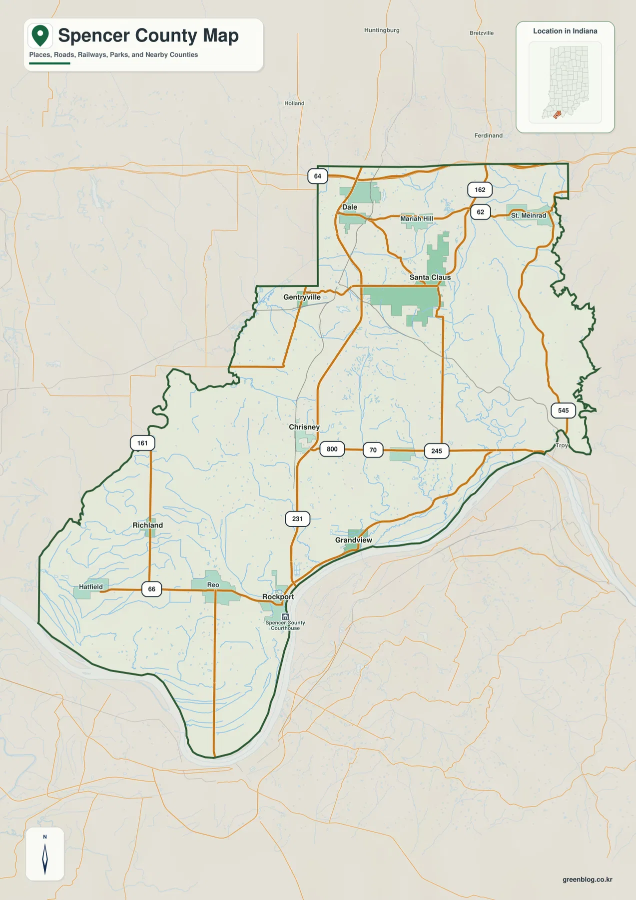
West of Rockport, Reo and Richland occupy the interior and Hatfield sits farther west. Route 66 crosses the southwestern part of the county, while Route 161 provides a north–south reference near the western boundary. Numerous small waterways cross this side of the map, so the road pattern is easiest to read after Rockport and Route 66 have been established as anchors.
East of Rockport, the labels 70 and 245 help distinguish the Grandview side from the central interior. Route 545 follows the eastern side toward the Ohio River, while Routes 62 and 162 appear farther north around the St. Meinrad direction. These routes occupy different levels of the county rather than one continuous eastern corridor, which is why separate town references are more useful than a single road line.
The general map works best for relative position, county boundary shape, and major road direction. It does not establish current construction, closures, or travel restrictions. For actual trips, the route numbers here are useful for orientation, while present road conditions should be checked with a current transportation source.
The highlighted towns stretch from Santa Claus and Dale to the river edge
The city map strips away much of the secondary road detail and makes Spencer County’s long settlement pattern immediately visible. Santa Claus occupies the northern interior, Dale is northwest of it, and Chrisney lies farther south and west. Rockport sits near the Ohio River, Grandview lies east of Rockport, and Richland marks the lower western interior. The six highlighted places are therefore spread over a long north–south distance rather than clustered around one central town.
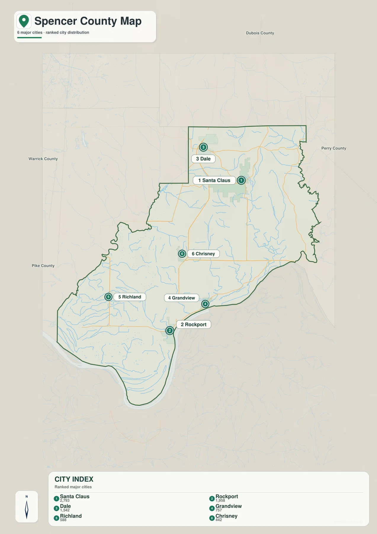
The CITY INDEX also prints numeric values beside the place names, but the supplied package does not identify a statistical year or provide a separate source for those figures. This article therefore does not present them as current official population. A current U.S. Census product should be used when up-to-date population is required; the city map is used here for the geographic relationship among the named places.
The strongest settlement contrast is between the river towns and the northern interior. Rockport and Grandview occupy the broad Ohio River lowland, while Santa Claus and Dale sit on much hillier ground. Chrisney works well as a middle reference along the U.S. 231 side, and Richland helps orient the lower western area. Returning to the road map after learning this pattern makes the numbered routes easier to follow.
Neighboring county labels add regional context. Dubois County lies to the north, Perry County to the east, and Warrick and Pike counties lie to the west. Dale and Santa Claus are close to the northern side of Spencer County, while Rockport is near its southern end. Those labels reinforce the county’s long shape without requiring detailed local-road knowledge.
The Ohio River collects southern tributaries while creeks and lakes break up the north
The Ohio River dominates the terrain-and-water map. It forms the broad southern boundary and curves below Rockport and Grandview. Little Sandy Creek and Sandy Creek descend toward the river in the south-central and southeastern part of the county, while Crooked Creek follows a separate valley farther east. The river edge is therefore not a single flat strip; several tributary valleys reach it from the interior.
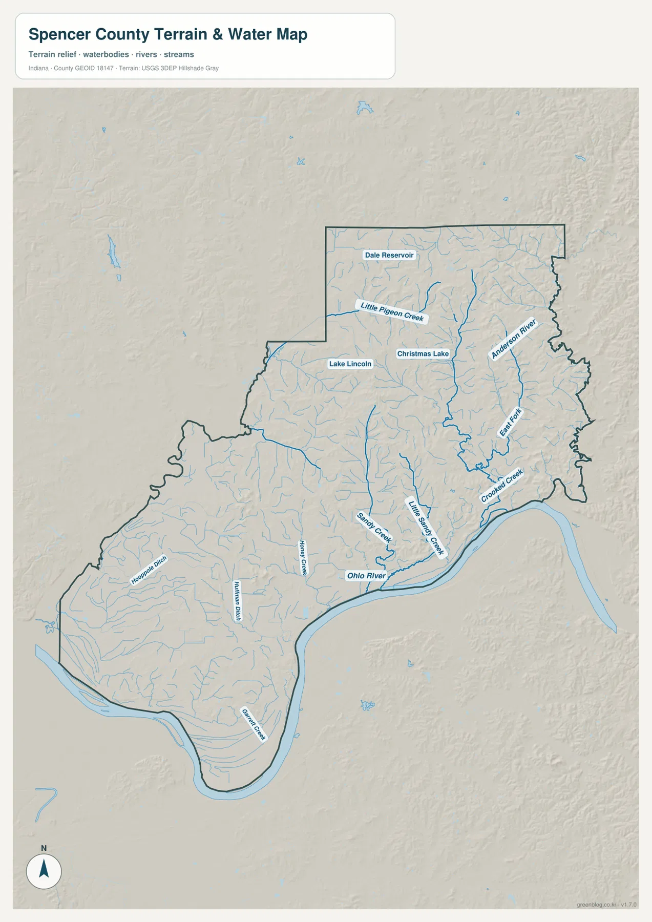
Northern Spencer County contains several separate water features. Little Pigeon Creek crosses the northern interior, Dale Reservoir is labeled near the Dale side, and Lake Lincoln and Christmas Lake occupy different positions farther south and east. The map does not show them as one connected lake system. Using Dale and Santa Claus as place references makes their relative position much easier to compare.
The eastern side contains Anderson River and a labeled East Fork within its broader drainage area. Crooked Creek lies farther south, while Little Sandy Creek and Sandy Creek occupy the central-southern map. In the west, Honey Creek, Huffman Ditch, and Hooppole Ditch are among the named channels. Spencer County is therefore divided among several drainage areas rather than organized around one inland river.
This terrain-and-water view is a county-scale reference, not a flood map, parcel map, legal water-boundary product, depth chart, drainage-engineering plan, or navigation guide. It is appropriate for locating the Ohio River, named creeks, reservoirs, and lakes and comparing their position with towns and the county boundary. Current flood conditions or site-specific water questions require dedicated agency data.
The 109–201 meter relief range separates river lowlands from northern ridges
The elevation legend reports an actual Spencer County range of about 109 to 201 meters and a mean of 132 meters. Green represents lower terrain in the county-scale display, shifting through yellow and tan to brown at higher elevations. Broad green surfaces follow the Ohio River boundary and extend across the southwest, creating a clear contrast with the hillier northern half.
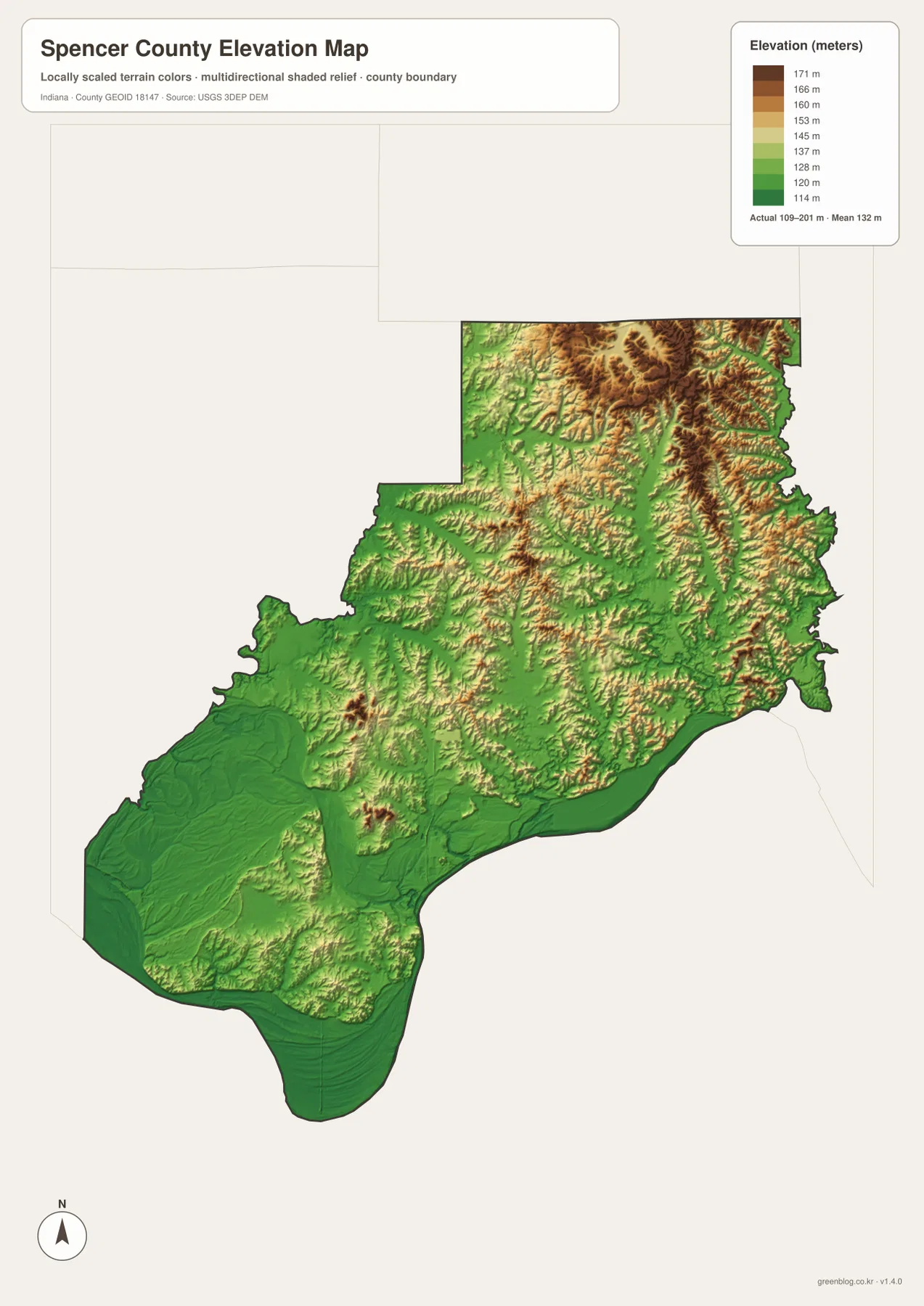
The northern half contains far more closely spaced ridges and valleys. Around the Santa Claus and St. Meinrad directions, brown high ground is broken by narrow green corridors. The northeast is especially dissected, with short ridges repeating between tributary valleys. Locating Anderson River and northern creeks on the water map before opening the elevation view makes those lower corridors easier to recognize.
Central Spencer County forms a transition between the river lowlands and the northern hills. North of Chrisney and south of Santa Claus, lower valleys and moderate ridges alternate over relatively short distances. The terrain therefore does not rise at one constant rate from south to north. A better countywide picture is a broad Ohio River lowland, a mixed central belt, and a much more strongly dissected northern and northeastern upland.
The elevation surface is designed for county-level comparison rather than survey-grade measurement. It should not be used to assign an exact elevation to a building, road point, field, or construction site. The range and mean are useful regional reference values, but precise site elevations require source data or professional survey measurements.
Keep Rockport or Santa Claus fixed while switching between the maps
For roads and named places, begin with the general county map and locate Rockport, Santa Claus, and U.S. 231. The city map is useful when road detail is unnecessary and the goal is to compare the north–south distribution of Santa Claus, Dale, Chrisney, Rockport, Grandview, and Richland. Returning to the road view after that makes the numbered routes easier to place.
For water features, use the terrain-and-water map to locate the Ohio River, Anderson River, Little Pigeon Creek, Crooked Creek, Dale Reservoir, Lake Lincoln, and Christmas Lake. Then find the same areas on the elevation map. The southern river edge appears as a broad lowland, while northern waterways occupy narrower valleys between higher ridges.
The WebP previews are optimized for browser viewing. The downloadable ZIP contains the original high-resolution JPG versions of the general county map, city map, terrain-and-water map, and elevation map. Each file is a portrait image measuring 2572 by 3638 pixels, making the originals better for enlarging small road and creek labels or preparing an A3 print.
A practical comparison routine is to keep one familiar town fixed. Starting from Rockport, follow the Ohio River and U.S. 231 on the road map, then compare the southern tributaries and low green terrain on the physical maps. Starting from Santa Claus instead makes it easier to connect the northern lakes, tributary valleys, and brown ridge system. Both approaches show how strongly Spencer County changes from south to north.
Frequently Asked Questions
Which road is the easiest north–south reference in Spencer County?
U.S. 231 is one of the clearest references because it connects the Rockport side with Chrisney and continues toward the Dale direction. It does not cover every important place, so roads on the eastern side still need to be checked separately when locating Grandview or St. Meinrad.
Are Dale Reservoir, Lake Lincoln, and Christmas Lake one connected lake system?
No. The supplied water map labels Dale Reservoir, Lake Lincoln, and Christmas Lake separately at different positions in northern Spencer County. They should be treated as distinct water bodies rather than one connected lake system.
Where is the strongest terrain contrast on the elevation map?
The clearest contrast is between the low green terrain along the Ohio River and across the southwest and the higher brown ridges in the north and northeast. The legend reports an actual range of about 109–201 meters and a mean of 132 meters. Tributary valleys still cut lower green corridors through the northern uplands.
Map File Information
Download the high-resolution JPG originals for the Spencer County general map, city map, terrain-and-water map, and elevation map in one ZIP. Use the originals when small road or creek labels need to remain clear or when preparing an A3 print.
- Printable Size: 2572×3638 px each
Related Maps
Sources and References
The road, settlement, water, and elevation descriptions above are based on the supplied Spencer County maps and asset information. The official resources below are useful when source boundary, hydrography, or elevation data is needed.
- U.S. Census Bureau TIGER/Line Shapefiles – official county boundary, road, and place reference data
- USGS National Hydrography – official river and stream data information
- USGS 3D Elevation Program – elevation source data and program information
Green Map creates custom-edited map images using open geographic data sources such as geoBoundaries, Natural Earth, OpenStreetMap, and government open data.
These maps are edited visual materials, not raw data files, and are provided for education, documents, presentations, and graphic reference.