Clay County sits on Georgia’s western border where the Chattahoochee River and Walter F. George Lake form a long water edge beside Alabama. Fort Gaines occupies that western shore, while Bluffton lies well inland toward the southeast. Four separate maps compare the county boundary and roads, the two incorporated places, the reservoir and creek network, and local elevation. A single ZIP contains the four high-resolution JPG files for documents, lessons, printed references, and county orientation.
The county is sparsely settled, but its geography is not visually simple. A broad reservoir cuts into the western side, small tributaries divide the interior into narrow valleys, major roads connect Fort Gaines with the US 27/SR 1 corridor, and rolling uplands rise above the low Chattahoochee shoreline. Looking at the maps together makes those relationships easier to understand than relying on a single political outline.
Table of Contents
Clay County on Georgia’s western water boundary
Clay County occupies part of southwest Georgia’s border with Alabama. Quitman County lies to the north, Randolph County to the northeast, Calhoun County to the east, and Early County to the south. The western side is different from those land boundaries because it follows the Chattahoochee River and Walter F. George Lake. On the county map, that shore creates a long irregular outline with coves and inlets rather than a simple straight county line.
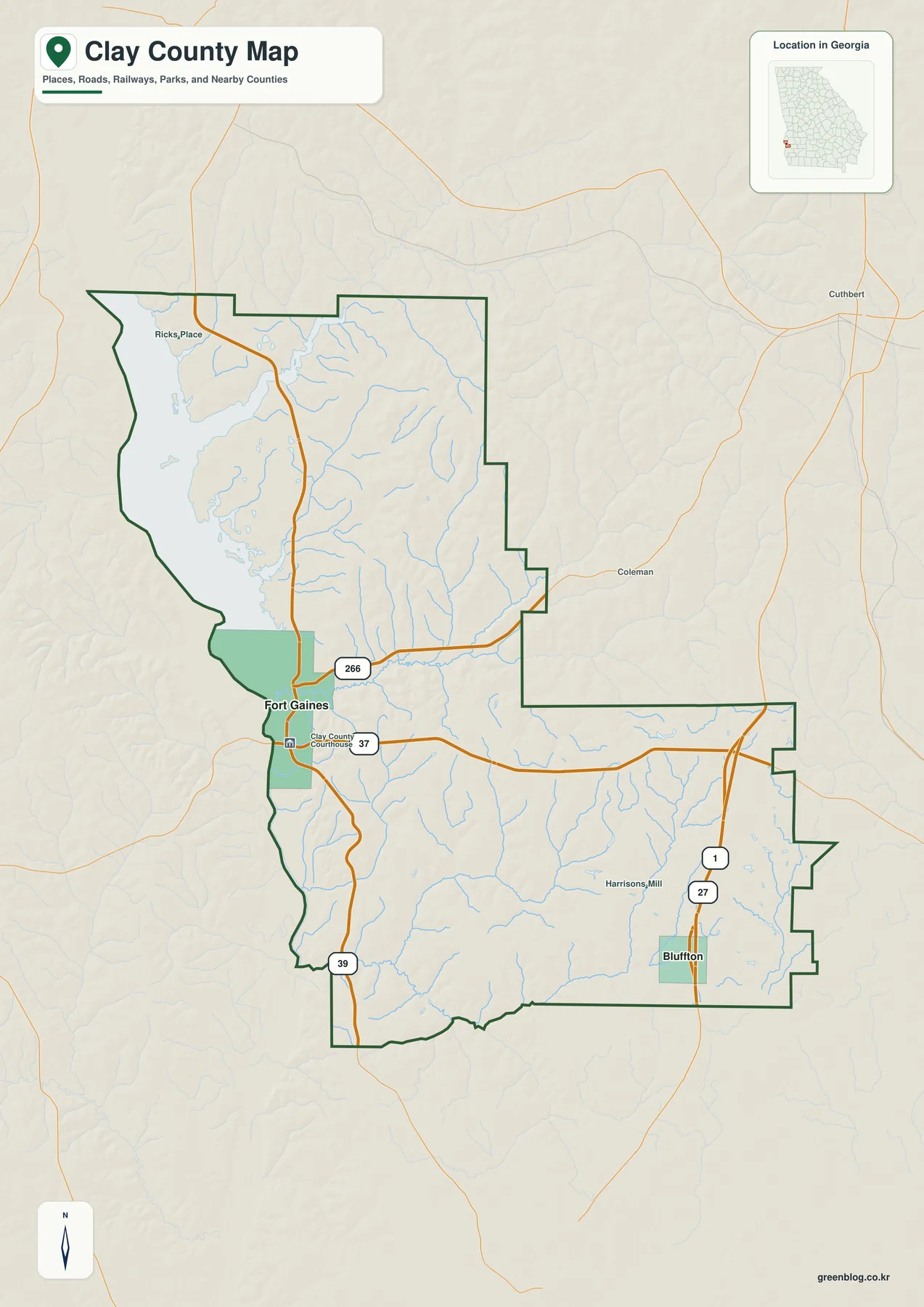
Fort Gaines is placed near the middle of the western edge and serves as the county seat. From there, the map extends east across the rural interior toward US 27/SR 1 and southeast toward Bluffton. Outside the county, labels such as Cuthbert and Coleman help establish regional context. Nearby towns in surrounding counties provide additional orientation points even though they are not part of Clay County itself.
| State | Georgia |
|---|---|
| County and FIPS | Clay County · 13061 |
| County seat | Fort Gaines |
| Incorporated places | Fort Gaines and Bluffton |
| Created | 1854 |
| 2020 Census population | 2,848 |
| July 1, 2025 population estimate | 2,815 |
| 2020 land area | 195.40 square miles |
| Major waters | Chattahoochee River, Walter F. George Lake, Pataula Creek |
| Download | ZIP with four high-resolution JPG maps |
The 2020 Census density was 14.6 residents per square mile. That low density explains why large stretches of the map contain roads, creeks, and rural land without many municipal labels. The open space between Fort Gaines and Bluffton is therefore part of the county’s real settlement pattern, not missing map detail. For general orientation, the boundary, road system, water edge, and the two incorporated places are more informative than a long list of minor place names.
Fort Gaines and Bluffton define the settlement pattern
The city map reduces the county to its two principal incorporated places. Fort Gaines is ranked first and appears on the western side beside Walter F. George Lake, while Bluffton is ranked second in the southeastern interior. The wide gap between them is crossed by rural roads and many small drainage valleys rather than a continuous urban corridor. That simple contrast helps explain why the county’s administrative center is tied closely to the Chattahoochee shore while its second municipality is oriented toward inland routes.
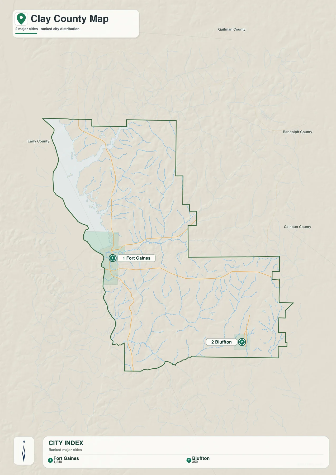
Fort Gaines functions as both the county seat and the most prominent settlement on the map. Bluffton provides a second reference point near the southeastern side of the county and close to the north-south US 27/SR 1 corridor. The city map also shows Early, Quitman, Randolph, and Calhoun counties, clarifying which side of Clay County each municipality lies nearest.
The numbered city symbols locate communities and provide a ranked reference rather than precise municipal footprints. Incorporated-boundary data, parcel maps, zoning maps, and service-area maps are separate datasets. Exact Fort Gaines or Bluffton boundaries come from current state or local-government boundary records.
Roads linking the reservoir shore with the inland county
The main county map shows Fort Gaines as an important road junction. Georgia Route 37 runs east from the city through the county and links toward the US 27/SR 1 corridor; west of Fort Gaines it continues across the state line into Alabama’s road network. Georgia Route 39 passes through the Fort Gaines area in a north-south direction and follows the Georgia side of the reservoir. Georgia Route 266 branches northeast from the Fort Gaines area toward the Cuthbert side of the region.
On the eastern side, US 27 and State Route 1 pass close to Bluffton and provide the strongest north-south highway reference on that side of the county. Comparing the western and eastern road patterns makes the county’s shape easier to understand: Fort Gaines faces the water boundary, while Bluffton is connected more directly to an inland highway corridor. A trip across the county therefore involves both the reservoir-oriented road network and the rolling interior.
The road network crosses uneven terrain. Small creeks and narrow valleys repeatedly cut through the interior, and the reservoir shoreline sends coves into the western side. Routes bend around or cross those features, so straight-line separation between two points can differ noticeably from driving distance. The map provides geographic orientation; current navigation, construction, bridge status, and closures come from up-to-date transportation information.
Walter F. George Lake, creeks, ponds, and interior valleys
Water is the county’s strongest physical feature. Walter F. George Lake occupies much of the western edge and is part of the Chattahoochee River system. The reservoir is also widely known as Lake Eufaula. Fort Gaines sits close to the eastern shore, and the lake widens north of the city where arms of water extend into the county. The shoreline is therefore a complex series of coves and tributary mouths rather than one smooth line.
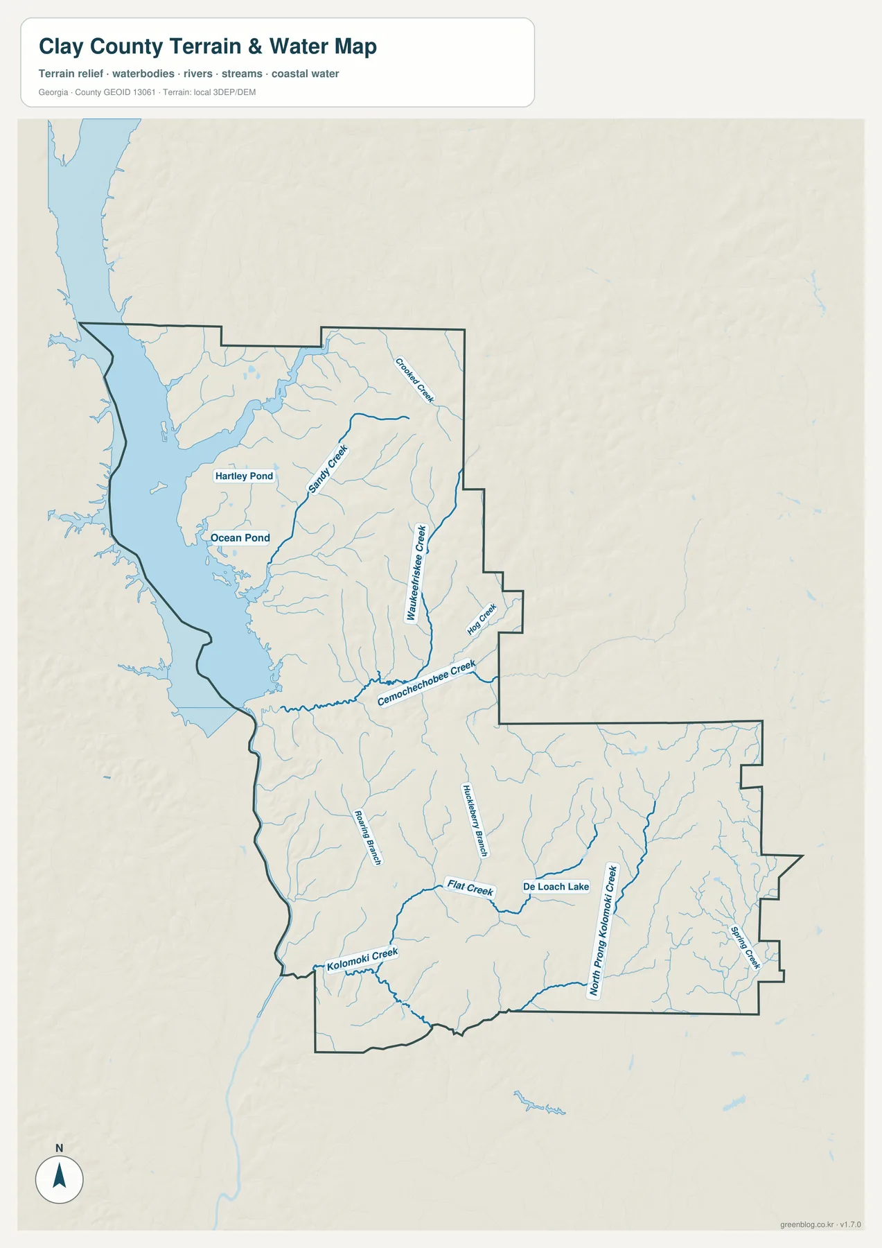
Inside the county, the water map labels several smaller systems, including Sandy Creek, Cemochechobee Creek, Flat Creek, Kolomoki Creek, North Prong Kolomoki Creek, and Spring Creek. Hartley Pond, Ocean Pond, and De Loach Lake provide additional local water references. These features show that the interior is divided by many small drainage lines even where no large river is visible. In the central and southern portions, tributaries branch repeatedly through narrow valleys before joining larger downstream systems.
Pataula Creek is another important tributary entering Walter F. George Lake in the northwestern part of the county. It adds another large valley and inlet to the reservoir side. When the water map is compared with the county map, the western shoreline becomes easier to interpret: broad blue reservoir water forms the state-facing edge, while thinner interior streams explain many of the smaller bends and low corridors farther east.
This water reference is not a flood map, navigation chart, parcel layer, or real-time lake-level product. It does not determine property flood status, safe boat channels, private shoreline boundaries, or current reservoir elevation. Those operational details come from current U.S. Army Corps of Engineers information and other responsible local or federal sources.
Elevation from the Chattahoochee lowlands to the eastern uplands
The elevation map shows that Clay County is not uniformly flat. The legend reports an actual range of about 36 to 156 meters, with a mean elevation of about 89 meters. The lowest broad areas appear along the western reservoir and river side, while higher colors become more common through the interior, especially toward the east and southeast. The result is a landscape of rolling uplands cut by many lower creek valleys.
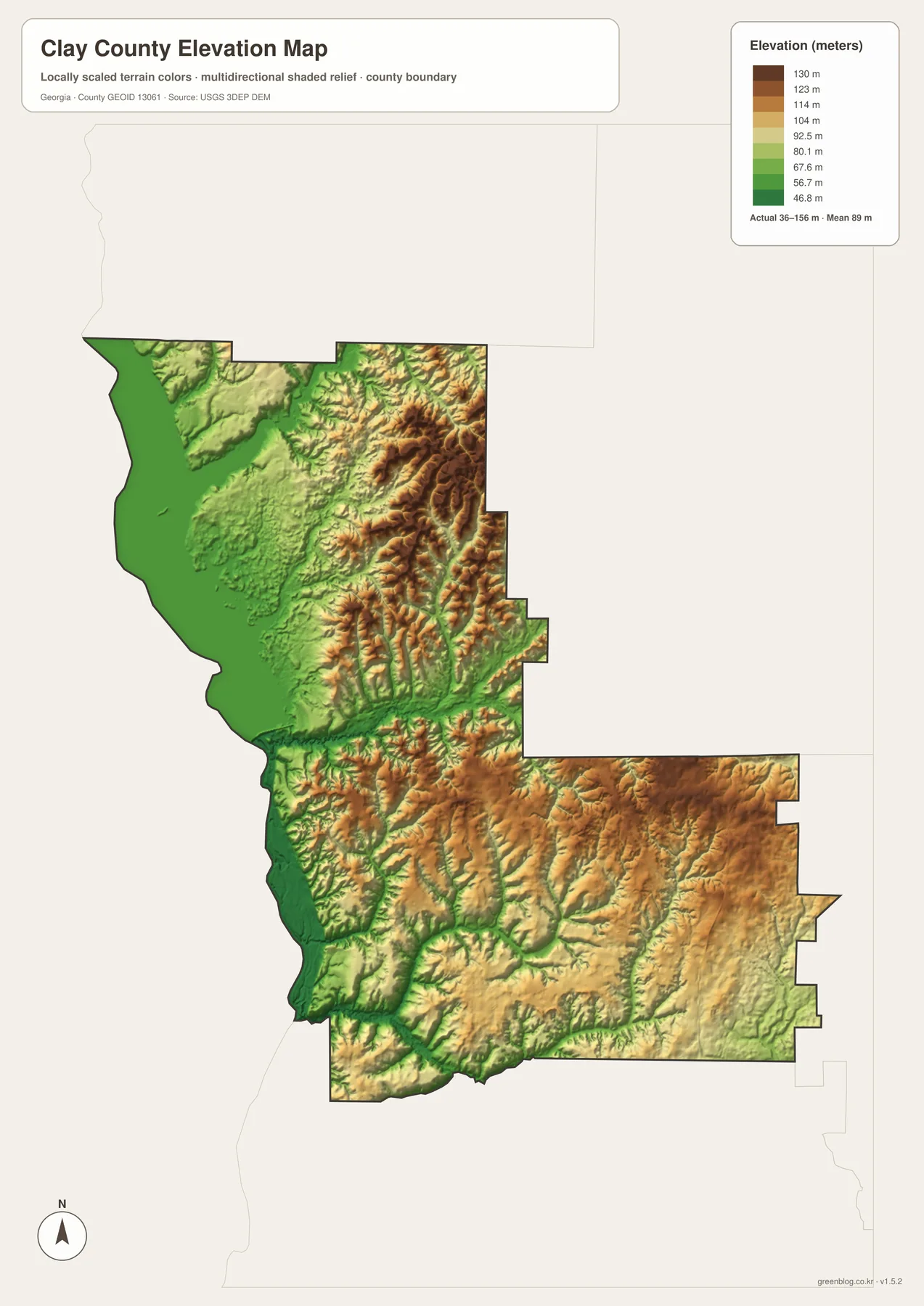
In the northeastern and eastern interior, narrow ridges and branching valleys appear as repeated bands of higher brown and lower green terrain. Similar relief continues across the southern half of the county, where creek corridors form green lines between higher hills. This pattern matches the dense network of streams shown on the water map. The waterways occupy many of the local lows, while the land between them rises into short ridges and rounded uplands.
The western shoreline near Walter F. George Lake is noticeably lower and more open in the elevation rendering. Fort Gaines lies close to that low water-side zone, whereas the Bluffton side of the county sits among more rolling inland terrain. The map compares relative terrain across the county. It is not survey-grade elevation data and does not establish building elevation, drainage design, engineering grade, or a precise elevation for a single parcel.
Frequently Asked Questions
Which main places are shown on the Clay County city map?
Fort Gaines and Bluffton are the two principal incorporated places shown. Fort Gaines is the county seat on the western reservoir side, while Bluffton is in the southeastern interior. Their separation provides a simple way to compare the county’s water-facing western side with its inland highway side.
Are Walter F. George Lake and Lake Eufaula the same reservoir?
Yes. They refer to the same reservoir on the Chattahoochee River. Federal project information uses Walter F. George Lake as the official project name and also recognizes Lake Eufaula as a widely used name. The broad water area along western Clay County is part of that reservoir.
What elevation range is shown on the Clay County elevation map?
The elevation map shows a range of about 36 to 156 meters and a mean of about 89 meters. Lower terrain is concentrated near the western reservoir and in creek valleys, while higher rolling ground is more common across the eastern and southeastern interior. These values are for county-scale terrain comparison, not parcel-level surveying.
What is included in the download ZIP?
The ZIP contains four high-resolution JPG files: the county map, city map, water map, and elevation map. They are suitable for general reference, printing, presentations, and documents. They serve as general references rather than replacements for legal boundary records, flood products, navigation charts, live road information, or survey-grade elevation data.
Map scope and limitations
These maps provide a general geographic reference in which the major boundary, roads, places, waterways, and elevation differences appear at county scale. The map set omits many local roads, property lines, voting districts, utility areas, zoning categories, and land-management boundaries. That distinction matters around the reservoir, where public management areas and private property may sit close together.
The water layer is likewise descriptive rather than operational. Blue lines and areas help identify where streams, ponds, and reservoir water occur. The layer provides location context rather than current flood conditions, water depth, navigable channels, or changing shoreline rules. The elevation layer uses a generalized terrain surface for county-scale comparison; precise site work depends on the underlying authoritative elevation source or a professional survey.
Road information is a location reference rather than live navigation. Route changes, closures, construction, and bridge conditions are maintained by current transportation sources. The downloadable maps support printed county references, school projects, presentations, local-history context, and comparisons between the Chattahoochee shore and inland uplands.
Map File Information
Clay County high-resolution map files
- Included Files: County overview, city, water, and elevation maps
- File Type: Four high-resolution JPG files in one ZIP file
- Suitable Formats: Printing, education, presentations, and map-based projects
Related Maps
Sources and References
- U.S. Census Bureau QuickFacts: Clay County, Georgia
- U.S. Census Bureau: County Population Totals and Components of Change, 2020–2025 — Vintage 2025 county population estimate series
- Georgia DCA: Clay County, Bluffton, and Fort Gaines comprehensive plan
- U.S. Army Corps of Engineers: Walter F. George Lake
- USGS National Hydrography
- USGS 3D Elevation Program
Green Map creates custom-edited map images using open geographic data sources such as geoBoundaries, Natural Earth, OpenStreetMap, and government open data. These maps are edited visual materials, not raw data files, and are provided for education, documents, presentations, and graphic reference.