Jay County lies along Indiana’s eastern edge, with Portland as the main central reference, Bryant and Pennville to the north, Dunkirk and Redkey in the southwest, and Salamonia toward the Ohio side of the county. You can download the high-resolution JPG ZIP directly from this page when you need larger road labels, stream names, terrain colors, or printable originals. This Jay County Map page connects the settlement and road pattern with the Salamonie River system, Bear and Limberlost creeks, the small Wabash River reach in the northeast, and a strong rise in elevation toward the south.
Portland is the easiest place to use for orientation. State Road 27 runs north-south through the Portland area, while State Road 26 approaches from the west and other east-west routes continue toward the Ohio border. Bryant sits north of Portland near the same central road corridor. Pennville is farther west, while Dunkirk and Redkey share the southwestern part of the county. Salamonia is separated to the east, which makes it especially useful when switching from the road map to the Salamonie River map.
The elevation surface adds a county-wide pattern that is much less obvious on the road map. The legend lists an actual range of about 231 to 341 meters and a mean of 282 meters. Lower green terrain dominates much of the north, while yellows and browns expand toward the south and southeast. Salamonie River and Little Salamonie River cut lower corridors through that rising ground, so the county is better understood as a broad north-to-south rise crossed by several stream valleys.
Table of Contents
Portland organizes the road map, with Bryant north and Dunkirk–Redkey southwest
The general county map makes Portland the strongest place reference. The developed area is larger than the surrounding towns, and State Road 27 provides a clear north-south line through the county. State Road 26 approaches Portland from the west, while roads continue east toward the Ohio border. Indiana’s official Jay County site identifies Portland as the county seat, which fits the map’s visual structure: it is both a government center and the point from which the county’s other towns are easiest to place.
Bryant lies north of Portland near the central road corridor and close to State Road 18, which runs east-west across the northern part of the county. Pennville is west of that line and is better associated with the northwestern road grid near State Road 1. Thinking of Bryant as north-central and Pennville as northwest avoids the impression that the two towns sit on one straight route.
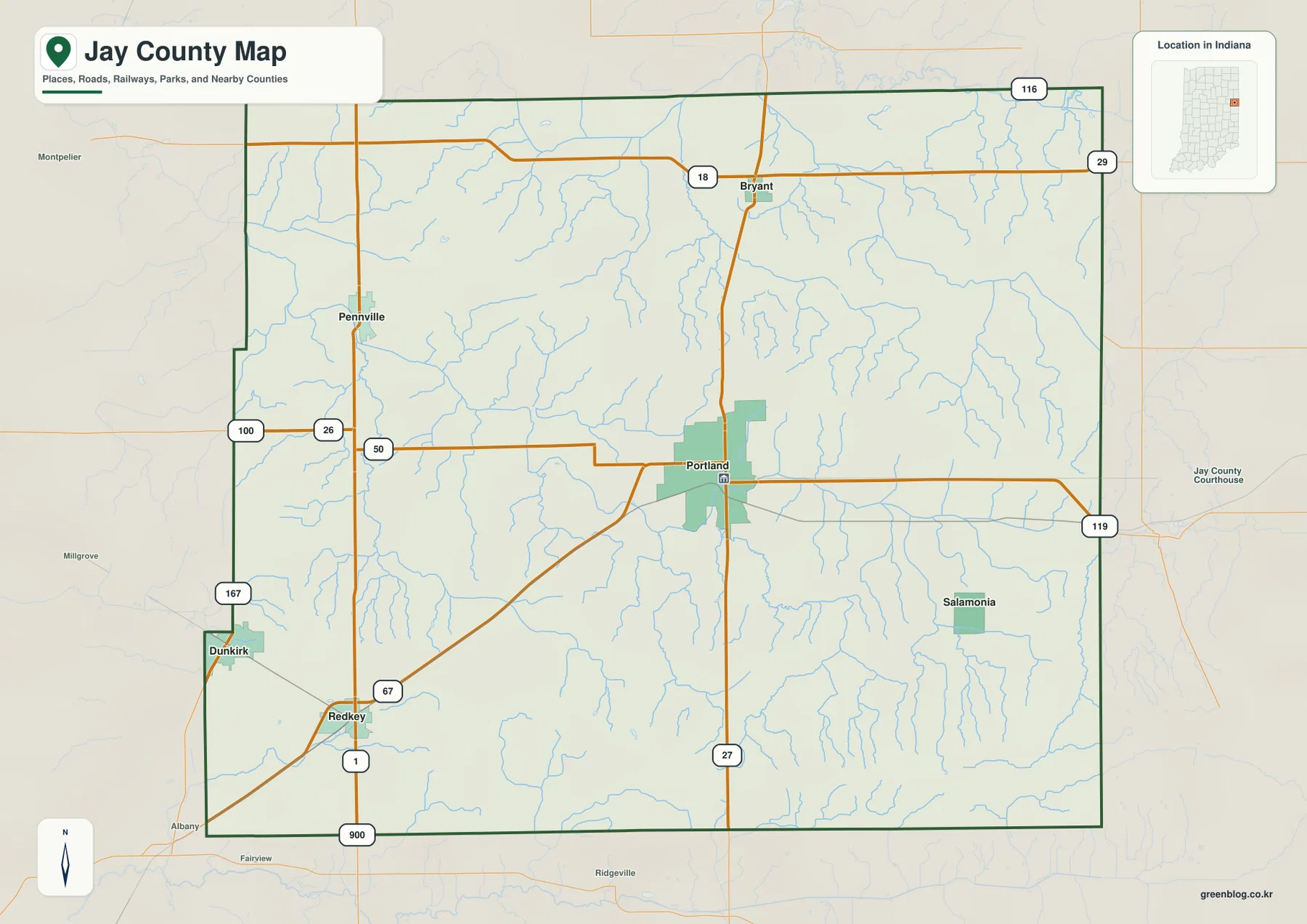
The southwest has its own recognizable road pattern. Redkey lies near State Road 1 and the diagonal State Road 67 corridor, while Dunkirk is farther northwest inside the stepped western county boundary. The two communities are relatively close to each other on the map but are separated from Portland by a broad rural interior. Their position makes them useful for recognizing the southwestern corner when city labels disappear on the terrain maps.
Salamonia is a small eastern settlement with a limited developed footprint, yet it becomes important in the water section because the Salamonie River begins near the Indiana–Ohio border in this part of Jay County. The general map therefore does more than place towns: it supplies the location framework needed to understand why the eastern side matters to the county’s drainage pattern.
The six-place city index separates Portland from two southwestern towns and smaller outer communities
The supplied city index highlights six places and prints a value beside each one. Portland is first at 6,416, followed by Dunkirk at 1,861 and Redkey at 1,332. Pennville is shown at 419, Bryant at 258, and Salamonia at 218. These figures should be treated as the values printed on the supplied map rather than as a guarantee of the newest population estimates. Their main value here is showing the contrast between the central county seat, the southwestern pair, and the smaller northern and eastern communities.
| Rank | Place | Value printed on map | Position |
|---|---|---|---|
| 1 | Portland | 6,416 | East of center |
| 2 | Dunkirk | 1,861 | Southwest |
| 3 | Redkey | 1,332 | Southwest |
| 4 | Pennville | 419 | Northwest |
| 5 | Bryant | 258 | North-central |
| 6 | Salamonia | 218 | East |
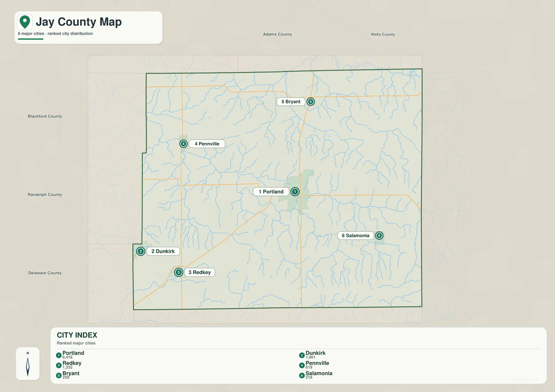
Dunkirk and Redkey share the southwest but do not occupy the same exact road position. Pennville and Bryant are both northern communities, yet they are spread from west to center rather than clustered tightly. Salamonia provides the eastern reference point. The index therefore helps show that Jay County’s settlements are distributed in several directions around Portland instead of forming one continuous chain.
The general map should still be used when actual route connections, neighboring counties, or the detailed county outline matter. The city index deliberately removes much of that detail. Current demographic work should also rely on the latest official statistics rather than assuming the printed map values are current population totals.
Salamonie River begins near Salamonia while Bear and Limberlost creeks drain the north
Salamonie River is the most important water feature across the middle and southern half of the supplied terrain map. Indiana IDEM’s Upper Salamonie River watershed plan states that the river has its origins near Salamonia, close to the Indiana–Ohio border in Jay County, before flowing west toward the Wabash system. That official description matches the map, where the Salamonie River enters the county’s interior from the eastern side and bends westward through the middle-south.
Little Salamonie River forms a separate southern drainage line. Brooks Creek and Butternut Creek approach from the west and south-central area, while Simison Creek and McLaughlin Ditch provide additional eastern and southeastern references. The similar Salamonie names can be confusing, so the simplest approach is to treat the main Salamonie River as the central feature and Little Salamonie River as the distinct southern branch system shown below it.
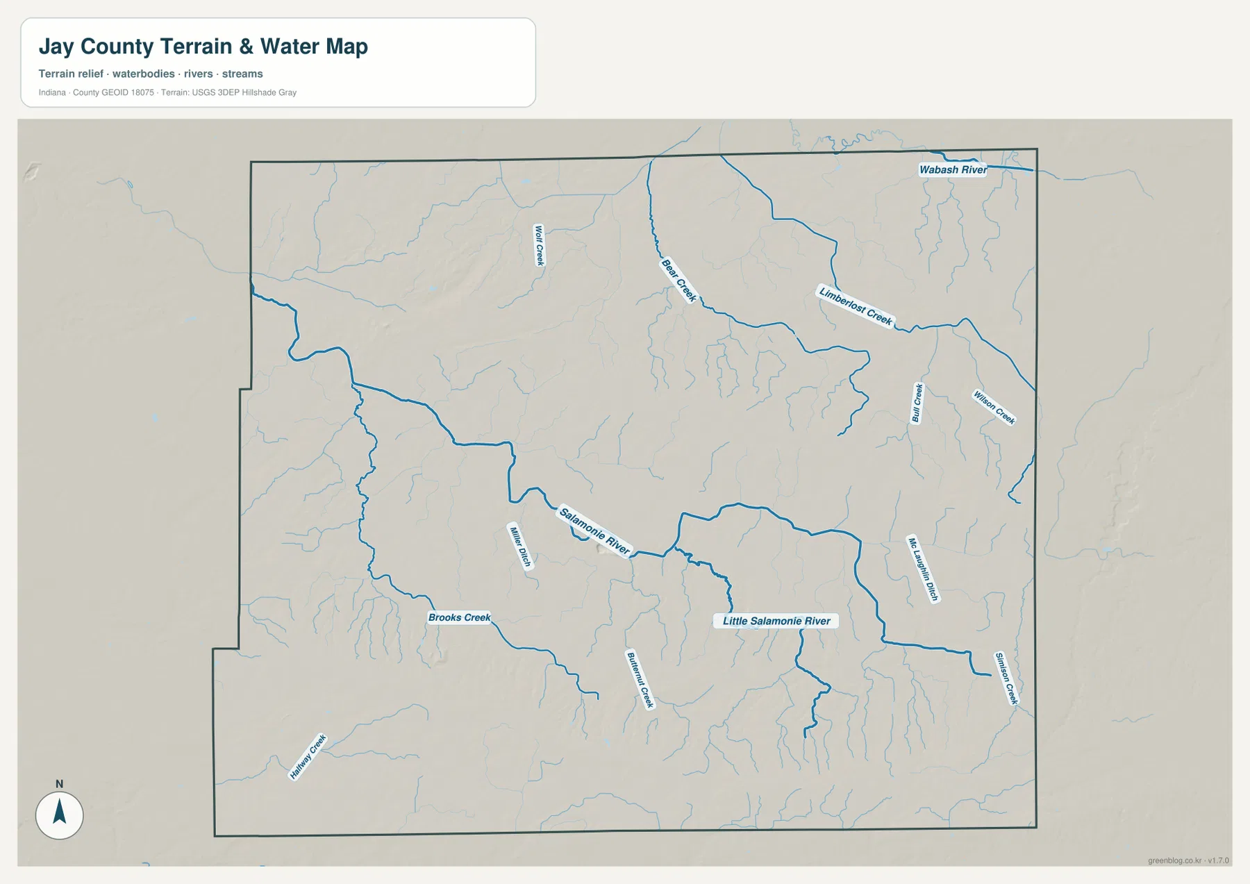
The northern drainage pattern is different. Bear Creek makes a long bend across the north-central area, and Limberlost Creek continues through the northeast. Wolf Creek is labeled farther west, while Bull Creek and Wilson Creek help divide the eastern side into smaller drainage areas. At the extreme northeast, a short Wabash River reach appears close to the county boundary, adding a major-river reference that is separate from the Salamonie system.
Rather than memorizing every creek and ditch, start with four broad references: Salamonie River through the middle-south, Little Salamonie River farther south, Bear–Limberlost drainage across the north, and Wabash River at the northeast edge. Once those are familiar, the smaller named tributaries become much easier to place.
This terrain-and-water view is a geographic reference, not a flood-zone, legal-boundary, navigation, current water-level, or water-quality product. A blue line does not establish a floodplain or property boundary. Those questions require current agency information. Here, the map is best used to understand how Jay County’s stream systems divide the landscape.
The 231–341 m elevation surface rises strongly toward the south and southeast
The elevation legend gives an actual Jay County range of about 231 to 341 meters and a mean of 282 meters. Greens mark lower terrain, while yellow, tan, and brown indicate higher ground. Much of the northern third is green, but the surface rises through the middle and becomes substantially higher across the southern and southeastern parts of the county. That north-south contrast is the clearest large-scale terrain feature on the map.
The north is not uniformly flat. A locally higher area appears in the northwest, while Bear Creek and Limberlost Creek cut lower green channels through the surrounding surface. The Bryant and Pennville side of the county is nevertheless lower overall than the broad high belt farther south. Comparing the city and elevation maps makes that regional difference easy to see.
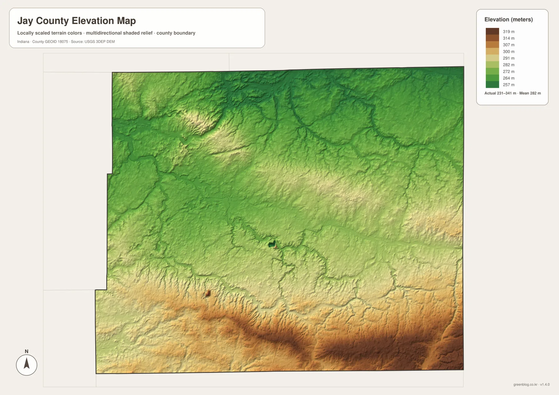
Salamonie River produces a lower corridor across the middle-south, and Little Salamonie River creates another low line farther south. These valleys interrupt the broader rise toward the southern boundary. The south therefore should not be imagined as one flat elevated surface; it is a higher regional background crossed by several lower drainage cuts.
The warmest colors are concentrated toward the southern and southeastern edges. Areas south of the Redkey and Salamonia reference points are clearly higher than the northern lowlands, though individual creeks still carve narrow green channels into that high ground. The road map does not make this difference obvious, which is why the elevation view adds useful information rather than simply repeating the settlement map.
The 231–341 m range is a county-scale reference, not a survey measurement for a property or engineering project. Building elevations, road grades, drainage design, and parcel-level work require source elevation data or professional surveying. The USGS 3D Elevation Program is a better starting point for precise terrain information. The supplied image is designed for broad comparison of lower northern ground, higher southern terrain, and stream-cut valleys.
Start with Portland for orientation, then use the river and elevation maps to understand the north–south contrast
For first-time orientation, begin with the general map. Find Portland and State Road 27, then place Bryant to the north, Pennville to the northwest, Dunkirk and Redkey in the southwest, and Salamonia to the east. This view contains the broadest selection of road numbers, settlement labels, and neighboring-county references.
Use the city index when the main question is how the six highlighted places compare. Portland is clearly the largest printed value, Dunkirk and Redkey form the stronger southwestern pair, and the remaining three communities occupy smaller northern and eastern positions. Current population analysis should use the latest official statistics rather than assuming the index is current.
For physical geography, locate Salamonie River first, then move south to Little Salamonie River and north toward Bear Creek and Limberlost Creek. Open the elevation map beside the water map and look for those same streams as lower corridors. That comparison makes the broad rise from northern lowlands to southern high ground much easier to understand.
The web previews are optimized for quick page viewing. Small creek labels, road numbers, and fine terrain changes are easier to see in the original files. The download archive contains the county/general map, city index map, terrain-and-water map, and elevation map as 3638×2572-pixel JPG originals. Download the ZIP when you want to zoom farther, print the maps, or compare the full-resolution originals side by side.
A useful comparison method is to follow the same area through several views. Find Portland and Salamonia on the general map, switch to the water map to trace Salamonie River westward, and then check the elevation surface to see how the valley cuts through higher southern terrain. In the north, compare Bryant and Pennville with Bear Creek and Limberlost Creek. Repeating the same locations across several maps turns separate images into a clearer picture of Jay County.
Frequently Asked Questions
What is the easiest way to find Portland on the map?
Look for the largest developed area near the east-central part of Jay County and use State Road 27 as the main north-south reference. Portland is the county seat, Bryant is farther north, Dunkirk and Redkey are southwest, and Salamonia is east of Portland near the Ohio side.
Where does Salamonie River begin in Jay County?
Indiana IDEM’s Upper Salamonie River watershed plan states that the river begins near Salamonia, close to the Indiana–Ohio border in Jay County. The supplied water map shows the same eastern origin area and the river continuing westward. Little Salamonie River is a separate watercourse farther south.
Can the 231–341 m elevation range be used as an exact property elevation?
No. The supplied elevation map gives a county-wide range of about 231 to 341 meters, with a mean of 282 meters. It is intended to compare broad lower and higher areas, including the northern lowlands and southern high ground. Exact property, construction, drainage, or engineering elevations require source elevation data or professional survey work.
Map File Information
This ZIP contains the Jay County general map, city index map, terrain-and-water map, and elevation map as high-resolution JPG originals for enlarged viewing and printing.
- File Type: ZIP containing four 3638×2572px JPG files
Related Maps
Sources and References
The article is based primarily on the supplied Jay County map set and asset manifest. The following official sources provide county, watershed, boundary, hydrography, and elevation references.
- Jay County, Indiana – official county information and Portland government context
- Indiana IDEM – Upper Salamonie River Watershed – official watershed information including the river origin near Salamonia
- U.S. Census Bureau TIGER/Line Shapefiles – boundary and geographic reference data
- USGS National Hydrography – hydrography reference data
- USGS 3D Elevation Program – elevation source data
Green Map creates custom-edited map images using open geographic data sources such as geoBoundaries, Natural Earth, OpenStreetMap, and government open data.
These maps are edited visual materials, not raw data files, and are provided for education, documents, presentations, and graphic reference.