Jefferson County occupies a rugged stretch of southern Indiana where Madison sits above the Ohio River, Hanover lies just to the west, Dupont is farther north, and Canaan is tucked into the northeastern hill country. You can download the high-resolution JPG ZIP directly from this page when you need larger road labels, stream names, relief colors, or printable originals. This Jefferson County Indiana Map page connects the road network around Madison with direct city distances, the Ohio River and creek valleys, and an elevation surface that rises sharply from the river lowland into the eastern ridges.
Madison is the easiest place to use for orientation. U.S. 421 approaches from the north, State Road 7 reaches the city from the northwest, and State Road 56 follows the river-side corridor toward Hanover. Dupont lies near the northwestern edge, while Canaan is farther northeast among more deeply cut hills. Deputy and Kent provide western references in a lower, gentler part of the county.
The terrain views show why Jefferson County looks different from a simple river county. The elevation legend gives an actual range of about 129 to 297 meters and a mean of 232 meters. The Ohio River edge and parts of the west are low and green, but the east and northeast are filled with high brown ridges separated by narrow green valleys. Big Creek, Harberts Creek, Indian-Kentuck Creek, and other streams carve deeply into that higher terrain.
Table of Contents
Madison and the Ohio River provide the clearest road reference for Jefferson County
The general county map makes Madison immediately visible as the largest developed area. U.S. 421 runs south into the city, State Road 7 approaches from the northwest, and State Road 56 connects the Madison river corridor with Hanover to the west. The Jefferson County Courthouse and Sheriff’s Office labels also help identify the central government area within Madison.
Hanover sits west of Madison near the Ohio River and is linked by the river-side east-west road. Farther southwest, State Road 62 runs through the long southern extension of the county. This lower part of Jefferson County is visually separate from the northeastern hill country and helps explain why the county outline stretches much farther south on its western side than it does around Madison.
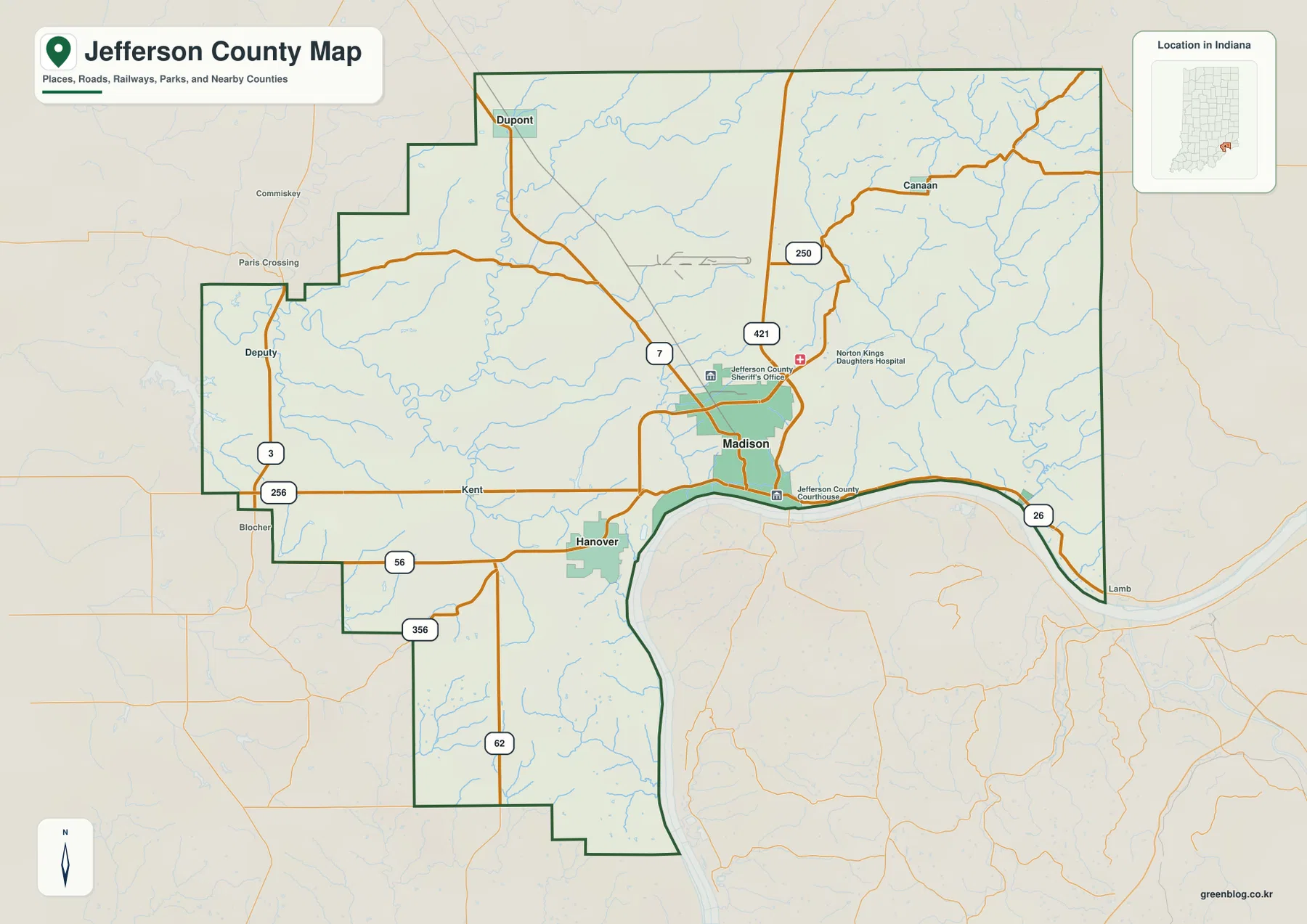
The northern and northeastern road pattern is more irregular. Dupont is close to the northwestern edge and connects to the State Road 7 corridor, while Canaan is farther east near State Road 250. Roads in the northeast bend through a landscape of ridges and creek valleys rather than following a simple straight grid. That pattern becomes much easier to understand after comparing the road map with the water and elevation maps.
The western side is organized by smaller communities such as Deputy and Kent. State Roads 3 and 256 help locate the far-western section, while State Road 56 continues east from the Kent area. The western county boundary steps repeatedly rather than forming one straight line, a shape that remains useful as a location clue when the city labels disappear on the terrain maps.
The city-connections map compares Hanover, Brooksburg, and Dupont with Madison
The supplied city-connections map uses Madison as the hub and highlights Hanover, Brooksburg, and Dupont. The printed index values are 12,223 for Madison, 3,554 for Hanover, 279 for Dupont, and 111 for Brooksburg. These figures are best treated as the values printed on the supplied map rather than as a guarantee of the newest population estimates. The map’s strongest feature is the simple comparison of direction and direct distance from Madison.
| Map rank | Place | Value printed on map | Straight-line distance from Madison | Direction |
|---|---|---|---|---|
| 1 | Madison | 12,223 | Hub | Southeast / riverfront |
| 2 | Hanover | 3,554 | 5 mi | West |
| 3 | Dupont | 279 | 11 mi | Northwest |
| 4 | Brooksburg | 111 | 8 mi | East |
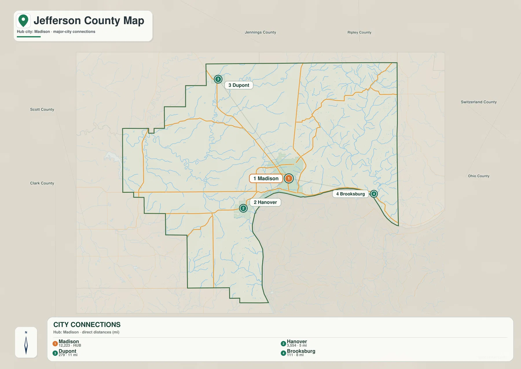
The 5-, 8-, and 11-mile labels are straight-line distances between mapped place points, not road-driving distances. Actual travel depends on the road chosen and the exact starting and ending locations. Hanover is the nearest highlighted place and sits on the same broad river-side corridor as Madison. Brooksburg is east along the Ohio River side, while Dupont is farther away to the northwest.
Madison’s role as the hub also matches county government context. Jefferson County’s official county-seat ordinance states that Madison is the regular place for conducting county government affairs. The city-connections map still should not be read as a commuting, traffic-volume, or municipal-boundary product; it is designed for simple place comparison.
Ohio River forms the southern edge while Big Creek and Indian-Kentuck Creek cut the eastern hills
The terrain-and-water map makes the Ohio River the dominant southern reference. The river follows the county boundary in a broad curve below Madison and continues east. Its valley is also the lowest major feature on the elevation map, so the river connects the water and relief views more clearly than any other landmark.
The eastern hill country is divided by several long creek valleys. Indian-Kentuck Creek runs south through the eastern half, while Big Creek bends through the northern and northeastern interior. Harberts Creek and Brushy Creek create additional long cuts through the central uplands. None of these streams is as wide as the Ohio River, but their narrow valleys are extremely important to the shape of the terrain.
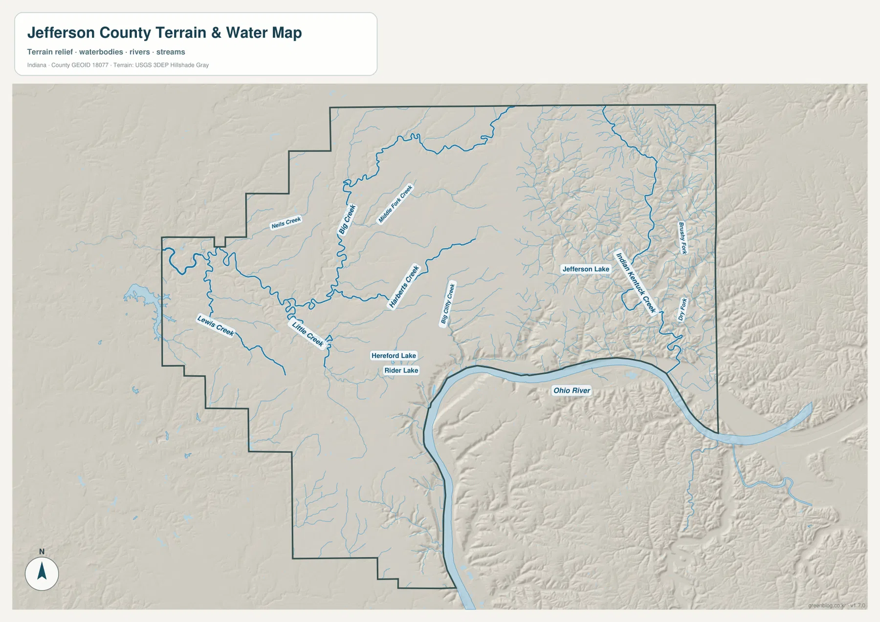
The western half is gentler but still contains a clear drainage network. Little Creek bends through the central-western area, Lewis Creek extends farther west, and Nells Creek appears toward the northwest. Middle Fork Creek provides another northern reference. These streams do not cut relief as dramatically as the eastern valleys, but they still create lower corridors across the rolling western terrain.
Hereford Lake and Rider Lake are labeled near the south-central interior, while Jefferson Lake appears farther east. They are local landmarks rather than county-scale reservoirs. When the road labels are removed, these smaller water bodies help orient the middle of the county between the Ohio River edge and the upland creeks.
This terrain-and-water map is intended for geographic reference, not for flood-zone, legal-boundary, navigation, current water-level, or water-quality decisions. A blue line or water polygon does not establish a floodplain or property boundary. Those questions require current agency information. Here, the map is best used to understand how the Ohio River and interior creek valleys divide Jefferson County.
The 129–297 m elevation surface rises sharply from the river lowland into the eastern ridges
The elevation legend gives an actual Jefferson County range of about 129 to 297 meters and a mean of 232 meters. Greens mark lower terrain, while yellow, tan, and brown show higher ground. The Ohio River edge is the most continuous low feature, and parts of the west are also relatively low. The east and northeast, however, rise into broad high ground that is repeatedly cut by narrow green valleys.
Madison sits near a strong terrain transition. The riverfront is low, but the land rises quickly north and northeast of the city. That change helps explain why the surrounding road network bends through the landscape rather than following a perfectly regular grid. A short distance inland, ridge tops and creek bottoms create much more relief than the broad Ohio River floodplain.
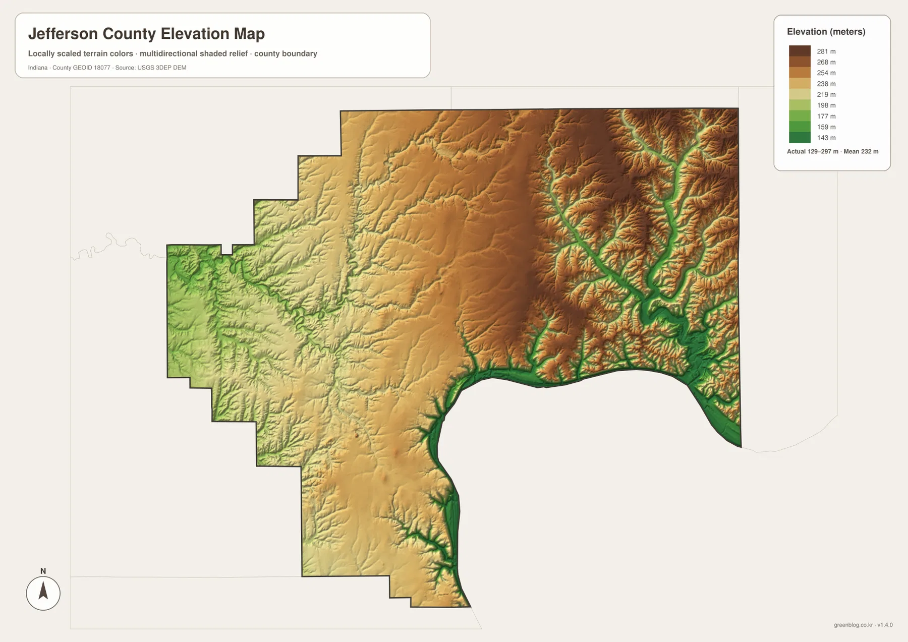
The eastern upland is not one smooth high surface. Big Creek and Indian-Kentuck Creek create deep green corridors through brown terrain, with additional tributaries branching into nearby ridges. Canaan and the northeastern side of the county lie within this more dissected landscape. The contrast between ridge tops and creek bottoms can be large even over short distances.
The west is lower and smoother overall, but Little Creek and Lewis Creek still carve visible valleys. The long southwestern extension of the county is generally lower than the central high ground, though it is not as low as the Ohio River edge. A useful first reading is to separate three broad elements: the Ohio River lowland, the central rolling surface, and the deeply dissected eastern ridges.
The 129–297 m range is a county-scale reference, not a survey measurement for a property or engineering project. Building elevations, road grades, drainage design, and parcel-level work require source elevation data or professional surveying. The USGS 3D Elevation Program is a better starting point for precise terrain information. The supplied image is designed for broad comparison of river lowlands, ridges, and creek valleys.
Use the road map for places, the city map for direct distances, and the terrain views for the Ohio River hills
For first-time orientation, begin with the general map. Find Madison and U.S. 421, then place Hanover to the west, Dupont to the northwest, Canaan to the northeast, and Deputy and Kent farther west. State Roads 7 and 56 provide the most useful additional lines for understanding the county’s central road network.
Use the city-connections map when the question is specifically how Hanover, Brooksburg, and Dupont relate to Madison. The supplied map shows direct distances of roughly 5, 8, and 11 miles. Driving distances are different, so travel planning should use current navigation or road information.
For physical geography, locate Ohio River first, then move inward to Big Creek, Indian-Kentuck Creek, and Little Creek. Open the elevation map beside the water map and look for the same streams as lower green corridors. That comparison makes the rapid rise from the river edge into the eastern ridges much easier to understand.
The web previews are optimized for quick page viewing. Small creek labels, road numbers, and fine relief changes are easier to see in the original files. The download archive contains the county/general map, city-connections map, terrain-and-water map, and elevation map as 3638×2572-pixel JPG originals. Download the ZIP when you want to zoom farther, print the maps, or compare the full-resolution originals side by side.
A useful comparison method is to follow one area through several views. Find Madison and Hanover on the general map, compare their position and distance on the city map, then switch to the water map to locate Ohio River and the interior creeks. Finally, check the elevation surface to see how quickly the terrain rises away from the river. Repeating the same locations across several maps turns separate images into a clearer picture of Jefferson County.
Frequently Asked Questions
How far are Hanover, Brooksburg, and Dupont from Madison on the city-connections map?
The supplied map shows Hanover about 5 miles west of Madison, Brooksburg about 8 miles east, and Dupont about 11 miles northwest. These are straight-line distances between mapped place points, not road-driving distances. Actual travel distance depends on the route and exact starting and ending locations.
Which waterways are easiest to recognize on the Jefferson County map?
Ohio River is the main southern reference. Inside the county, Big Creek, Harberts Creek, Indian-Kentuck Creek, Little Creek, and Lewis Creek divide the uplands into smaller valleys. The water map is intended for geographic reference and should not be used to determine flood risk or legal water boundaries.
Can the 129–297 m elevation range be used as an exact property elevation?
No. The supplied elevation map gives a county-wide range of about 129 to 297 meters, with a mean of 232 meters. It is intended to compare the Ohio River lowland, western rolling terrain, and higher eastern ridges. Exact property, construction, drainage, or engineering elevations require source elevation data or professional survey work.
Map File Information
This ZIP contains the Jefferson County general map, city-connections map, terrain-and-water map, and elevation map as high-resolution JPG originals for enlarged viewing and printing.
- File Type: ZIP containing four 3638×2572px JPG files
Related Maps
Sources and References
The article is based primarily on the supplied Jefferson County map set and asset manifest. The following official and public sources provide county, Madison, hydrography, and elevation references.
- Jefferson County, Indiana – official county government information
- Jefferson County County Seat Ordinance – official document identifying Madison as the county seat
- City of Madison, Indiana – official city government and riverfront context
- USGS National Hydrography – hydrography reference data
- USGS 3D Elevation Program – elevation source data
Green Map creates custom-edited map images using open geographic data sources such as geoBoundaries, Natural Earth, OpenStreetMap, and government open data.
These maps are edited visual materials, not raw data files, and are provided for education, documents, presentations, and graphic reference.