Jennings County is centered on the closely spaced communities of North Vernon and Vernon, with Scipio to the north, Hayden to the west, Butlerville to the east, and Commiskey and Paris Crossing farther south. You can download the high-resolution JPG ZIP directly from this page when you need larger road labels, creek names, elevation colors, or printable originals. This Jennings County Map page combines the settlement and road pattern with Vernon Fork Muscatatuck River, the county’s dense creek network, and a strong relief contrast between lower western ground and higher eastern ridges.
North Vernon is the easiest place to use for orientation because it has the largest developed footprint on the general map. Vernon sits immediately to the south beside a pronounced bend in the river system. Scipio and Country Squire Lakes provide northern and northwestern references, while Hayden lies farther west and Butlerville sits to the east. In the south, Commiskey and Paris Crossing extend the settlement pattern toward the stepped lower county boundary.
The elevation view makes Jennings County look much more rugged than the road map alone suggests. Its legend gives an actual range of about 137 to 273 meters and a mean of 215 meters. The west and southwest contain broad green lowlands, but the northeast and east rise into brown ridges cut by narrow creek valleys. Vernon Fork Muscatatuck River creates a lower central corridor between those two broad terrain zones.
Table of Contents
North Vernon and Vernon make the central road pattern easy to follow
The general county map places North Vernon at the center of the largest developed area. Roads leave the city in several directions, including a north-south corridor and the main eastward connection toward Butlerville. The North Vernon Police Department label helps identify the core of the built-up area. Vernon is much smaller but sits immediately south of North Vernon, where roads converge near the winding Muscatatuck drainage.
South of Vernon, roads marked 3 and 7 split toward different parts of the county. Route 3 continues toward Commiskey and Paris Crossing, while Route 7 heads southeast toward the stepped eastern boundary. North of North Vernon, the map also shows the 75 corridor and additional numbered roads across the rural northeast. These routes are useful because the county contains only a few larger settlement labels outside the central pair.
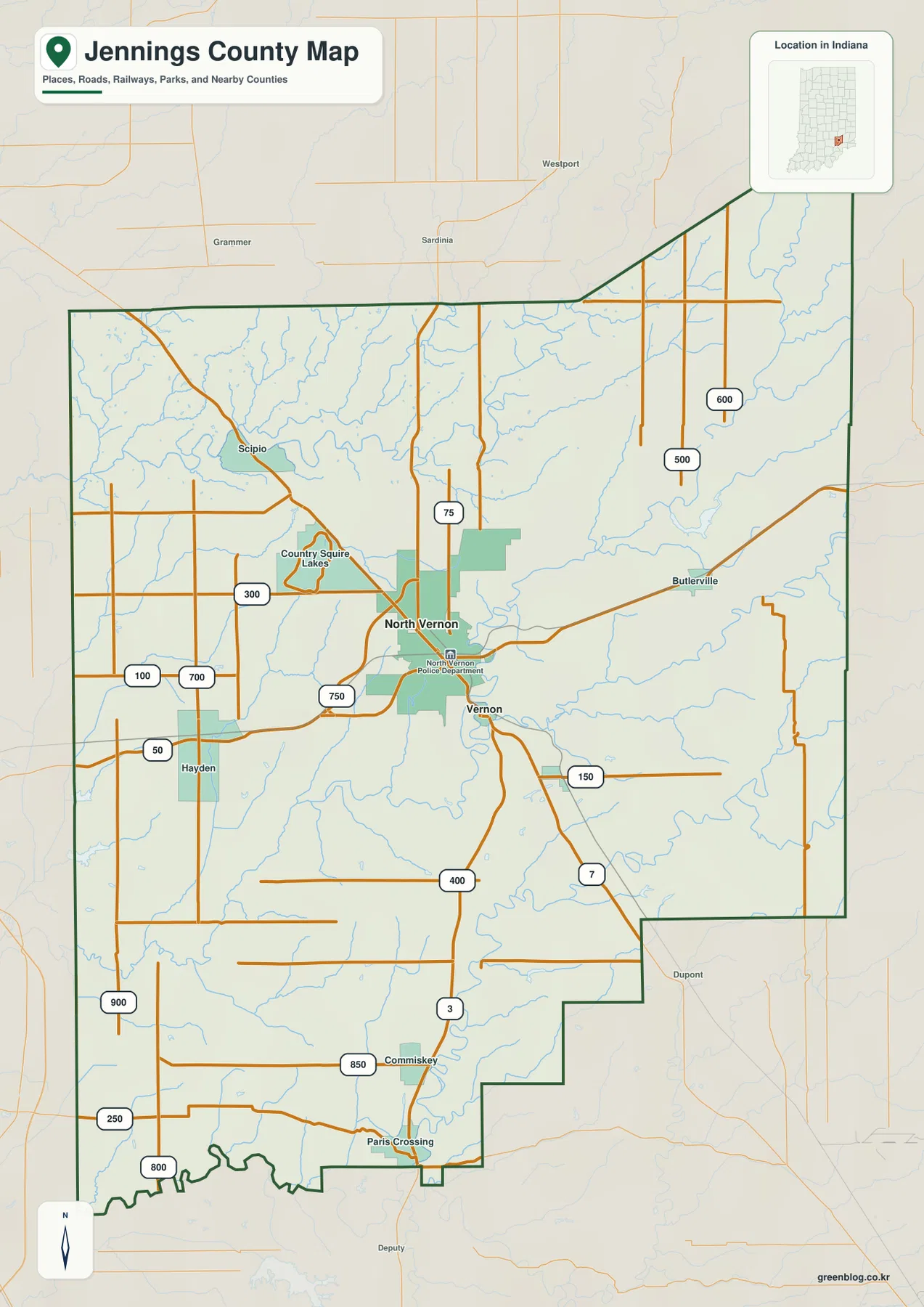
The western side has larger gaps between settlement labels. Hayden is a useful western reference, while Country Squire Lakes lies northeast of it and Scipio is farther north. The roads in this part of the county are generally easier to follow across the lower rolling terrain than the more deeply dissected eastern ridges. Comparing the general map with the elevation surface makes that contrast especially clear.
The eastern county outline is distinctive. The northeast boundary rises to a pointed extension, while the southeast steps inward several times before reaching the southern edge. Butlerville provides the clearest named reference inside that side of the county. On the water and elevation maps, where many road and city labels disappear, the unusual boundary shape becomes a practical way to keep track of the high eastern terrain.
The two-place city index shows the large difference between North Vernon and Vernon
The supplied city index highlights only North Vernon and Vernon. The values printed on the map are 7,078 for North Vernon and 193 for Vernon. These figures are best treated as the map’s index values rather than as a guarantee of the newest official population estimates. The simplified view is useful because it removes most other labels and shows how the county’s large urban center and much smaller county-seat town sit very close together.
| Rank | Place | Value printed on map | Position |
|---|---|---|---|
| 1 | North Vernon | 7,078 | Central / north of Vernon |
| 2 | Vernon | 193 | Immediately south of North Vernon |
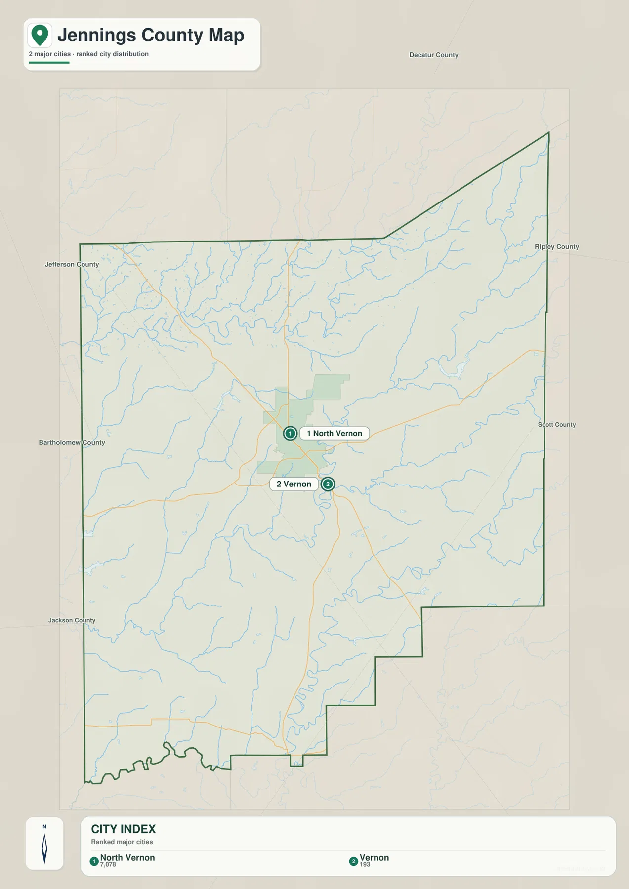
The proximity of the two places is almost as important as the difference in their printed values. North Vernon and Vernon are separated by only a short distance on the map, and the central road and stream network visually links them. Even so, the built-up footprints are very different, so they should not be treated as one continuous city. North Vernon occupies the broader urban area; Vernon forms a smaller center near the river bends.
Scipio, Hayden, Butlerville, Commiskey, Paris Crossing, and other local labels remain visible only on the general map. Their absence from the two-place index does not mean those areas are empty. The city index is intentionally narrow: it is designed to show the relationship between the two main highlighted places, not every settlement in Jennings County.
Indiana’s official county information identifies Vernon as the county seat and lists North Vernon and Vernon among Jennings County’s cities and towns. That administrative fact adds useful context to the supplied maps: North Vernon is visually much larger, but Vernon retains the county-seat role. The distinction is a good reminder that city size and county government location are not the same thing.
Vernon Fork Muscatatuck River bends through the center while northern and southern creeks cut the hills
Vernon Fork Muscatatuck River is the strongest interior water reference. It makes a large series of bends through the central part of the county near Vernon and continues south toward the Muscatatuck River system. The river occupies a lower corridor that is also visible on the elevation map, making it a useful bridge between the water and relief views.
Across the north, Sand Creek and Wyoosing Creek cross the northwestern and north-central areas, while Bear Creek forms a long northeastern drainage line. These creeks occupy lower cuts through increasingly high terrain. The contrast is especially strong around Bear Creek, where the surrounding ridges are substantially higher than the broad western lowlands.
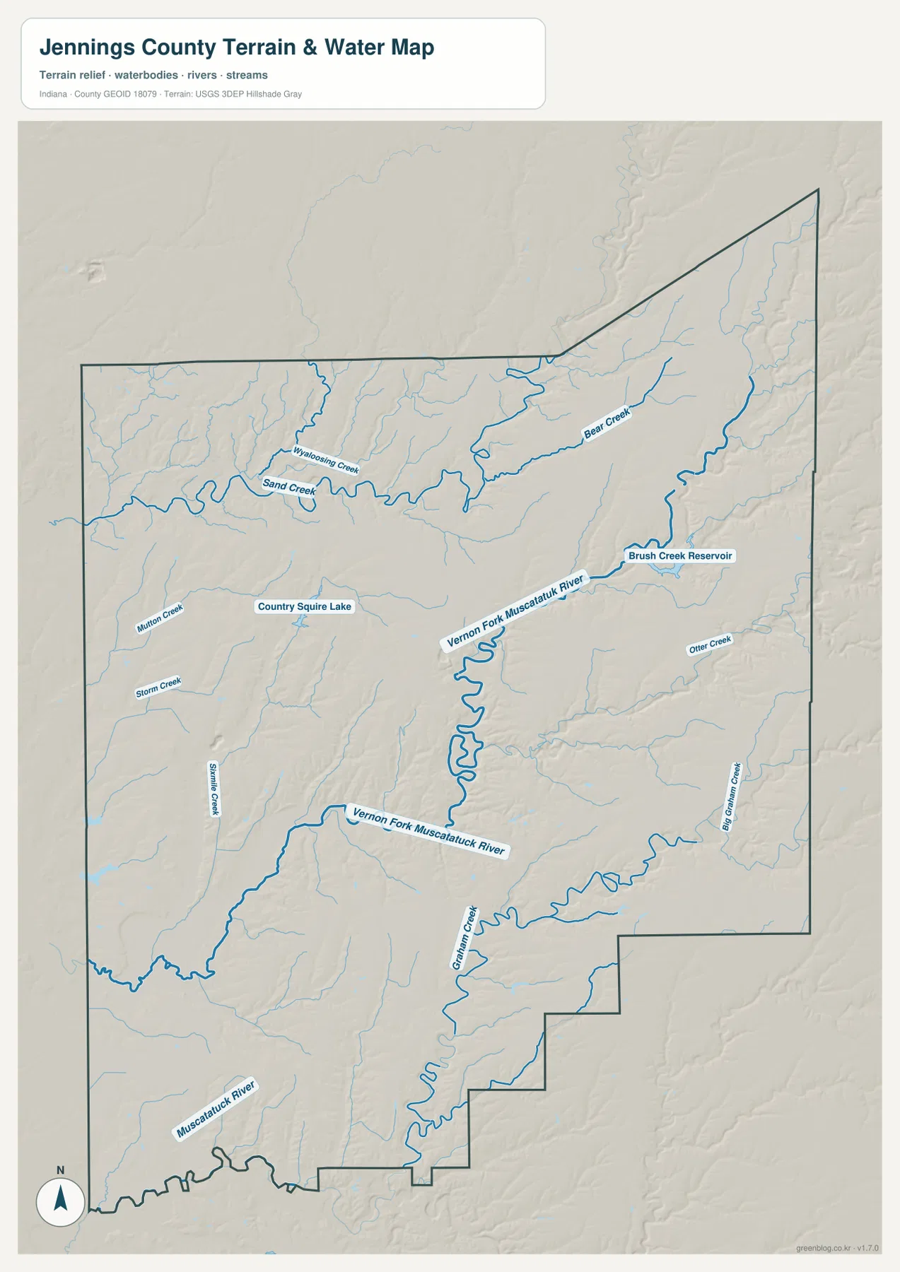
The southern half contains another group of named streams. Graham Creek and Big Graham Creek create long valleys in the east and southeast, while Starve Creek, Storm Creek, and Mutton Creek mark separate western drainage lines. Otter Creek appears farther east. Instead of memorizing every label, it is easier to use Vernon Fork Muscatatuck River as the central feature and then divide the smaller creeks into northern, western, and southern groups.
Brush Creek Reservoir and Country Squire Lake provide useful small-water landmarks. Brush Creek Reservoir lies in the east-central creek country, while Country Squire Lake is northwest of North Vernon. Neither is a county-scale lake, but each helps orient the water map when city names and roads are removed.
This terrain-and-water view is intended for geographic reference, not for flood-zone, legal-boundary, navigation, current water-level, or water-quality decisions. A blue line or water polygon does not establish a floodplain or property boundary. Those questions require current agency information. Here, the map is best used to see how the river and creek valleys divide Jennings County.
The 137–273 m surface rises from western lowlands into the eastern and northeastern ridges
The elevation legend gives an actual Jennings County range of about 137 to 273 meters and a mean of 215 meters. Greens indicate lower terrain, while yellow, tan, and brown show progressively higher ground. The west and southwest contain the broadest low areas. The surface rises through the center and becomes much higher and more dissected in the east and northeast.
The western side is not completely flat. Short ridges and creek valleys repeat around the Scipio–Hayden side, but their relief is gentler than the high eastern country. Moving toward North Vernon and Vernon, the colors become more varied. Vernon Fork Muscatatuck River then appears as a lower corridor through this central transition zone.
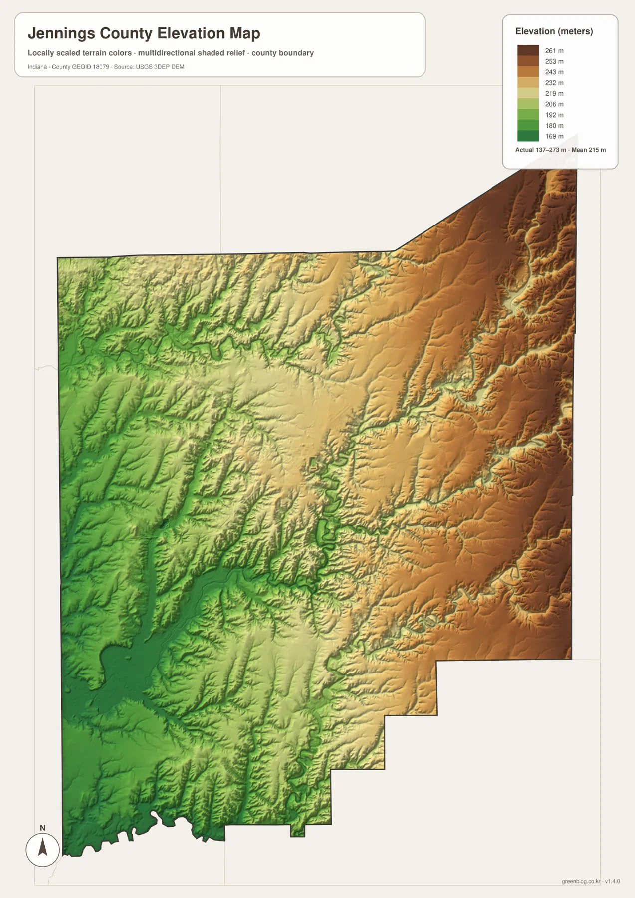
The northeast contains some of the darkest brown terrain on the map. Long ridges are separated by narrow green drainage cuts, including the Bear Creek corridor and its tributaries. This gives the Butlerville-to-northeastern-boundary side of the county a much rougher appearance than the lower western half.
The southeast is also high, but Vernon Fork and the Graham Creek system cut numerous lower valleys into the uplands. The stepped southeastern county boundary crosses a landscape of alternating ridges and drainage lines rather than one smooth plateau. A useful first reading is to separate the county into western lowlands, the central Muscatatuck valley zone, and the higher eastern ridges before looking at smaller creek valleys.
The 137–273 m range is a county-scale reference, not a survey measurement for a property or engineering project. Building elevations, road grades, drainage design, and parcel-level work require source elevation data or professional surveying. The USGS 3D Elevation Program is a better starting point for precise terrain information. The supplied image is designed for broad comparison of lowlands, ridges, and creek valleys.
Start with North Vernon, then follow the Muscatatuck valley into the eastern hill country
For first-time orientation, begin with the general map. Find North Vernon and Vernon, then place Scipio to the north, Hayden to the west, Butlerville to the east, and Commiskey and Paris Crossing to the south. The numbered north-south roads south of Vernon provide a simple framework for understanding the long lower half of the county.
Use the city index when the main question is the relationship between North Vernon and Vernon. The index removes most other labels and makes the large difference in printed values and developed footprint immediately visible. Current population analysis should use the latest official statistics rather than assuming the map index is current.
For physical geography, locate Vernon Fork Muscatatuck River first, then move north toward Sand Creek and Bear Creek and south toward Graham Creek and the Muscatatuck River. Open the elevation map beside the water map and look for those same streams as lower green corridors. That comparison makes the broad west-to-east rise and the rugged eastern creek valleys much easier to understand.
The web previews are optimized for quick page viewing. Small creek labels, road numbers, and fine relief changes are easier to see in the original files. The download archive contains the county/general map, city index map, terrain-and-water map, and elevation map as 2572×3638-pixel JPG originals. Download the ZIP when you want to zoom farther, print the maps, or compare the full-resolution originals side by side.
A useful comparison method is to follow the same area through several views. Find North Vernon and Vernon on the general map, compare their relative size on the city index, then switch to the water map to trace Vernon Fork Muscatatuck River through the center. Finally, check the elevation surface to see the lower central valley and the higher eastern ridges. Repeating the same locations across several maps turns separate images into a clearer picture of Jennings County.
Frequently Asked Questions
How do North Vernon and Vernon differ on the supplied maps?
North Vernon has the much larger developed footprint and a printed city-index value of 7,078, while Vernon is immediately to the south and is printed at 193. The two places are close together, but their map scale is very different. The printed figures are map-index values, so current population work should use the latest official statistics.
Where does Vernon Fork Muscatatuck River run through Jennings County?
The river bends through the central part of the county near Vernon and continues south toward the larger Muscatatuck system. Sand, Wyoosing, and Bear creeks lie farther north, while Graham Creek and other tributaries divide the southern and eastern hill country. The elevation map shows the river valley as lower ground compared with the surrounding ridges.
Can the 137–273 m elevation range be used as an exact property elevation?
No. The supplied elevation map gives a county-wide range of about 137 to 273 meters, with a mean of 215 meters. It is intended to compare broad western lowlands, the central river valley, and higher eastern ridges. Exact property, construction, drainage, or engineering elevations require source elevation data or professional survey work.
Map File Information
This ZIP contains the Jennings County general map, city index map, terrain-and-water map, and elevation map as high-resolution JPG originals for enlarged viewing and printing.
- File Type: ZIP containing four 2572×3638px JPG files
Related Maps
Sources and References
The article is based primarily on the supplied Jennings County map set and asset manifest. The following official and public sources provide county, county-seat, boundary, hydrography, and elevation references.
- Jennings County Government – official county government information
- IN.gov Counties – official state county reference identifying Vernon as the county seat and listing North Vernon and Vernon
- U.S. Census Bureau TIGER/Line Shapefiles – boundary and geographic reference data
- USGS National Hydrography – hydrography reference data
- USGS 3D Elevation Program – elevation source data
Green Map creates custom-edited map images using open geographic data sources such as geoBoundaries, Natural Earth, OpenStreetMap, and government open data.
These maps are edited visual materials, not raw data files, and are provided for education, documents, presentations, and graphic reference.