Gila County is not a compact urban county on the map. Its largest labeled communities are split between a northwest group around Payson and a southern group around Globe and Miami, with a broad mountainous interior between them. Pine, Strawberry, Star Valley, Young, Tonto Basin, Hayden, and other places occupy very different parts of that landscape, so the county makes more sense when viewed as several separated corridors rather than one continuous line of towns.
The maps on this page focus on that separation. One simplifies the major-city pattern, another restores the roads and smaller communities, and the terrain maps show why the routes are so indirect: high ridges, deep valleys, Theodore Roosevelt Lake, the Salt River, and many smaller drainages break up the interior. High-resolution JPG copies of the four supplied maps are available in the download box below.
Table of Contents
Payson and Globe sit in two clearly separated settlement groups
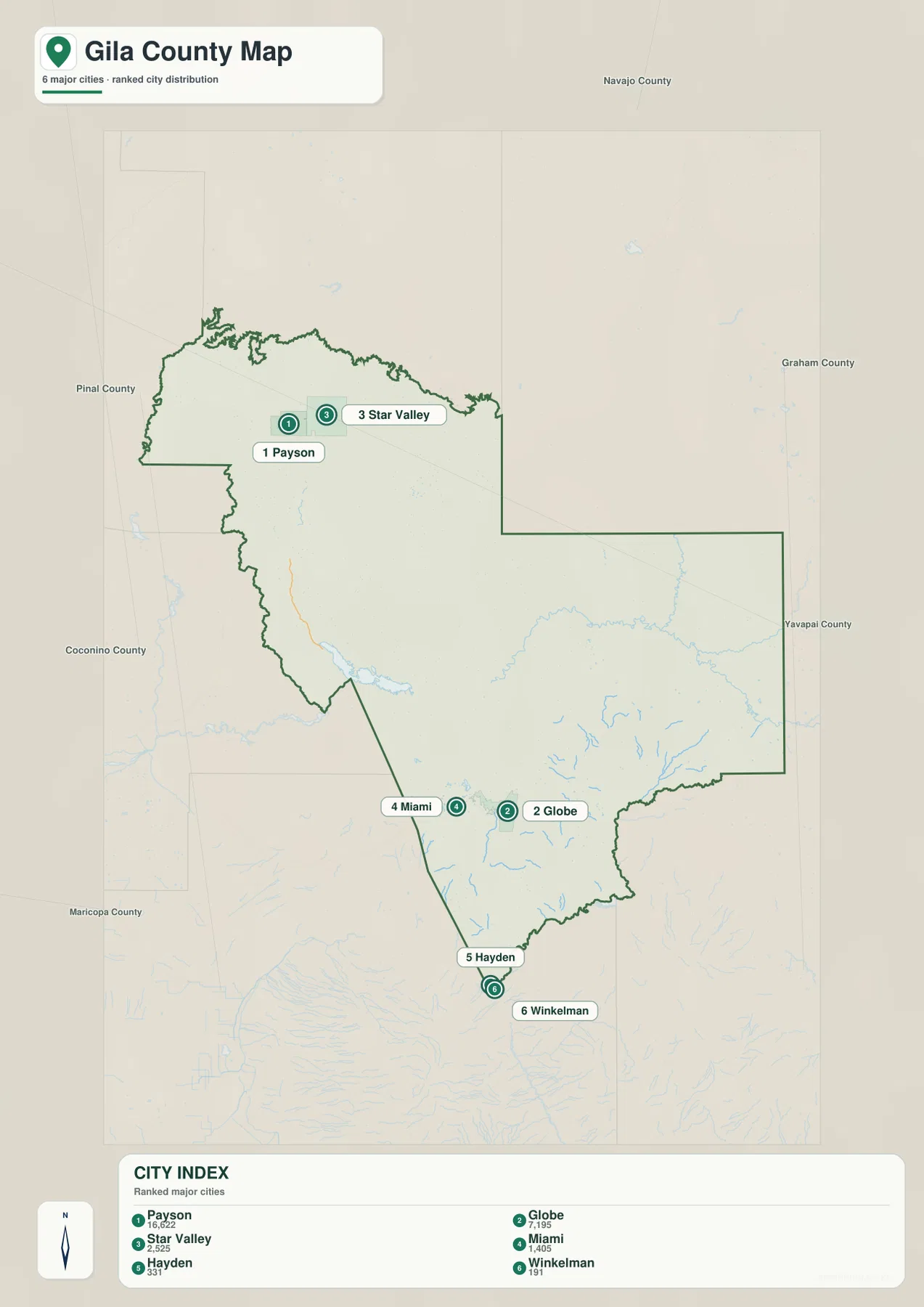
The major-city map is the fastest way to see Gila County’s basic settlement pattern. Payson is ranked first and Star Valley third in the northwest, while Globe is second and Miami fourth much farther south. Hayden and Winkelman occupy the southern end of the six-place index. With most road detail removed, the empty distance between the northwest and southern groups becomes one of the strongest features on the page.
The supplied city index lists 16,622 for Payson, 7,195 for Globe, 2,525 for Star Valley, and 1,405 for Miami, with smaller values shown for Hayden and Winkelman. These are values printed on the provided map and should not be treated as a replacement for a current Census population lookup. What matters for map reading is the rank and location: Payson dominates the northern cluster, Globe anchors the southern cluster, and there is no large city shown midway between them.
This simplified map leaves out several places that matter when navigating the county. Pine and Strawberry lie north of Payson; Young sits deep in the interior; Tonto Basin is west of the center; Carrizo and Cedar Creek appear in the east; and Wheatfields is north of Globe on the overview map. The city map is therefore best for comparing the principal population points, not for finding every community. Once the two-cluster pattern is clear, the road map explains how those places are connected.
The main roads bend around the mountainous interior
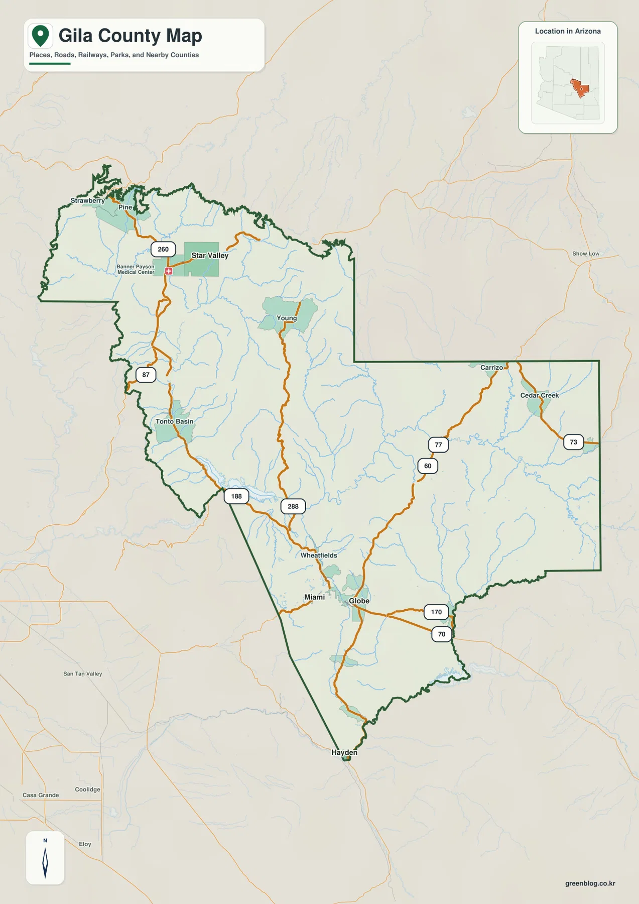
Adding the road network makes the gap between the city groups easier to interpret. AZ 87 serves the Payson side of the county, and Route 260 crosses east through Star Valley. Farther south, US 60 passes through the Globe and Miami area. These are strong local corridors, but they do not form a single straight north-south spine through Gila County.
Instead, the interior routes take long, terrain-shaped paths. AZ 188 approaches the Theodore Roosevelt Lake and Tonto Basin area before reaching the Globe side, while AZ 288 runs through Young along a more central mountain route. Routes 77 and 73 appear in the eastern section near Carrizo and Cedar Creek, and Routes 70 and 170 are shown southeast of Globe. The result is a network in which the road used depends heavily on which part of the county you are trying to reach.
The county boundary itself reinforces that complexity. The northwest edge around Pine and Strawberry is deeply irregular, the western side steps inward and outward around the Roosevelt Lake region, and the southern boundary narrows toward Hayden. For ordinary orientation, the overview map is useful because it combines that shape with road numbers, smaller place names, streams, and nearby terrain. It is not a live routing map, so current road closures, travel times, and driving distances should be checked separately.
The elevation map explains why the county is hard to cross directly
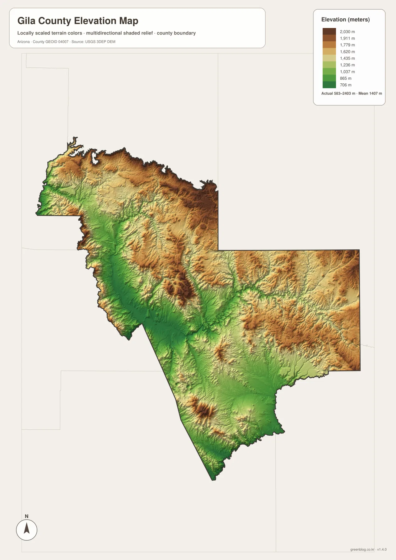
Gila County’s elevation surface ranges from about 583 to 2,403 meters on the supplied legend, with a mean of about 1,407 meters. The highest colors spread across much of the northern edge and appear again through the eastern mountains. Lower green corridors occupy broader areas in the west-central and southern portions of the county. This is not a simple slope from north to south; high ridges and lower valleys repeat in several parts of the map.
The Payson, Pine, and Strawberry area lies close to elevated terrain, while the interior around Young is also strongly mountainous. The Globe side is surrounded by relief as well, but lower corridors become more visible around the southern and western drainage routes. That alternating pattern helps explain the road map: highways frequently curve around ridges or use lower passages rather than taking direct lines between the northern and southern settlement groups.
The elevation colors are meant for county-scale comparison. They are useful for seeing where the land is broadly higher or lower, but not for determining the exact elevation of a parcel, building, road grade, or construction site. Surveying and engineering work require original high-resolution elevation data or professional measurements. For general map reading, this image is most useful when paired with the road and water maps to see how valleys guide both travel and drainage.
Roosevelt Lake dominates the west while eastern creeks follow separate valleys
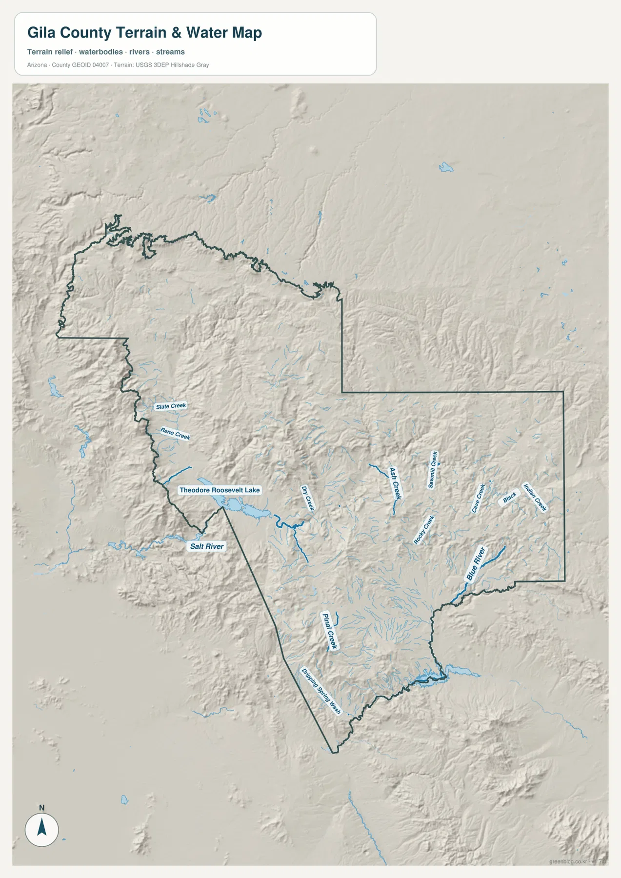
Theodore Roosevelt Lake is the most obvious water body on the terrain-and-water map. It sits in the western half of the county with the Salt River extending away from it, and Dry Creek approaching from the east. Slate Creek and Reno Creek are labeled farther north along the western side. Because the shaded relief is visible beneath the water lines, the lake and river system can be seen as part of a lower corridor surrounded by much rougher terrain.
South of the lake, Pinal Creek appears in the interior near the broader Globe–Miami region. Small tributaries spread through the surrounding ridges rather than following a single broad valley. This is a useful contrast with the city map: places that look like simple points on a blank background sit inside a much more complicated drainage network once terrain is restored.
The eastern half has a different pattern. Blue River is shown near the southeastern boundary, while Ash Creek, Rocky Creek, Sawmill Creek, Grave Creek, Black Creek, and Indian Creek occupy separate mountain valleys farther north and west. There is no Roosevelt-sized water body organizing that side of the map. Instead, the eastern terrain is divided among many smaller drainages, which is why reading the creek labels together with the shaded ridges is more useful than looking for one central river.
This map is intended for geographic reference, not hazard or navigation decisions. Blue lines do not guarantee continuous year-round flow, and the image does not provide current water levels, flood zones, parcel boundaries, or boating information. Its value is in showing where major water features lie relative to the county boundary and how drainage routes fit the mountain relief.
Use the simplest map that answers your question first
If you only need the relative positions of the main settlements, begin with the city map. It quickly separates Payson and Star Valley from Globe, Miami, Hayden, and Winkelman. When you need Pine, Strawberry, Young, Tonto Basin, Carrizo, Cedar Creek, Wheatfields, or road numbers, switch to the county overview. That map gives the extra detail needed to understand how the major corridors approach each part of the county.
For landscape questions, the elevation and water maps work better as a pair. The elevation image shows where the high ridges and low corridors are, while the terrain-and-water image identifies Roosevelt Lake, the Salt River, Blue River, and individual creeks within those corridors. The two maps explain much of the indirect road pattern without turning the page into a technical GIS report.
The WebP images above are reduced for convenient webpage viewing. The downloadable ZIP contains the original high-resolution JPG versions, which are more suitable for printing, slides, classroom materials, and documents. These are general reference maps; legal boundaries, live road conditions, flood risk, and survey-grade elevation should always be checked with the appropriate official source.
Frequently Asked Questions
Why do Payson and Globe look so disconnected on the county maps?
They occupy different settlement clusters with a large mountainous interior between them. Payson is in the northwest, while Globe is much farther south, and the road network bends through Tonto Basin, Roosevelt Lake, Young, and other terrain-defined corridors instead of following one direct north-south highway. The city map shows the separation most simply, and the county map explains the roads behind it.
Which map is best for locating Theodore Roosevelt Lake and nearby waterways?
Use the terrain-and-water map. Roosevelt Lake is clearly labeled in the western half of the county, with the Salt River and Dry Creek nearby. The same map also shows Pinal Creek, Blue River, and several eastern creeks, making it easier to compare the lake-centered western drainage with the more divided eastern mountain valleys.
Is the elevation map accurate enough for engineering or parcel work?
No. It is a generalized county-scale surface for comparing broad high and low areas. The supplied legend shows a range of roughly 583 to 2,403 meters, but individual properties, road grades, and construction sites require original USGS elevation data or professional surveying.
Map File Information
The ZIP contains the original high-resolution JPG versions of the major-city map, county overview, elevation map, and terrain-and-water map used on this page.
- File Type: JPG
Related Maps
Sources and references
For additional county context, see the Discover Gila County official tourism site and its Roosevelt Lake guide. Boundary and mapping references include the U.S. Census Bureau TIGER/Line Shapefiles, USGS National Hydrography, and the USGS 3D Elevation Program. Place, road, waterway, and elevation descriptions in this article are based primarily on the supplied Gila County map images.
Green Map creates custom-edited map images using open geographic data sources such as geoBoundaries, Natural Earth, OpenStreetMap, and government open data. These maps are edited visual materials, not raw data files, and are provided for education, documents, presentations, and graphic reference.