Download high-resolution A3 JPG maps of Franklin County, Texas from the ZIP box on this page, including the county, city, water, and elevation views shown below. Mount Vernon provides the clearest central reference, with Interstate 30 and U.S. 67 running east-west and Route 37 crossing north-south. The county’s physical geography changes markedly away from that road junction: Sulphur River follows the irregular northern edge, while Big Cypress Creek and Lake Cypress Springs define a more rugged and water-rich southern area. Elevation ranges from about 91 to 187 meters, with broad low terrain in the north and higher ridges through much of the center and south.
Franklin County is narrow from west to east and much longer from north to south, so a few strong landmarks are enough to establish orientation. Mount Vernon sits a little north of the vertical midpoint. Scroggins and the Winnsboro side appear toward the south, where streams become more numerous and the terrain grows more deeply cut. North of Mount Vernon, the surface is generally lower and the top boundary follows the bends of Sulphur River. Reading the road, water, and elevation views together makes this north-south contrast much easier to see than the boundary outline alone.
Table of Contents
Mount Vernon at the I-30, U.S. 67, and Route 37 Crossroads
The general county map gives Mount Vernon a strong visual position because several major routes meet in the same area. Interstate 30 runs east-west just south of the city center, while U.S. 67 follows another east-west line slightly farther north. Route 37 crosses both and continues through much of the county from north to south. With those three roads located, smaller roads, streams, and communities become much easier to place.
North of Mount Vernon, Route 37 continues toward the irregular Sulphur River boundary. The road layout remains fairly simple even though the drainage network becomes denser near the northern edge. South of the city, Route 37 creates a long vertical reference toward Scroggins and the Winnsboro side. The contrast between the straight transportation lines and the branching blue creek network is one of the most noticeable features of the county map.
The general view includes labels beyond Mount Vernon, but it does not present a dense chain of similarly sized towns. That matters when reading the map. Instead of treating every place label as an equivalent urban center, it is more useful to establish Mount Vernon first, follow the main east-west and north-south roads, and then examine how the surrounding rural areas are divided by creeks and reservoir valleys.
A One-City Index Centered on Mount Vernon
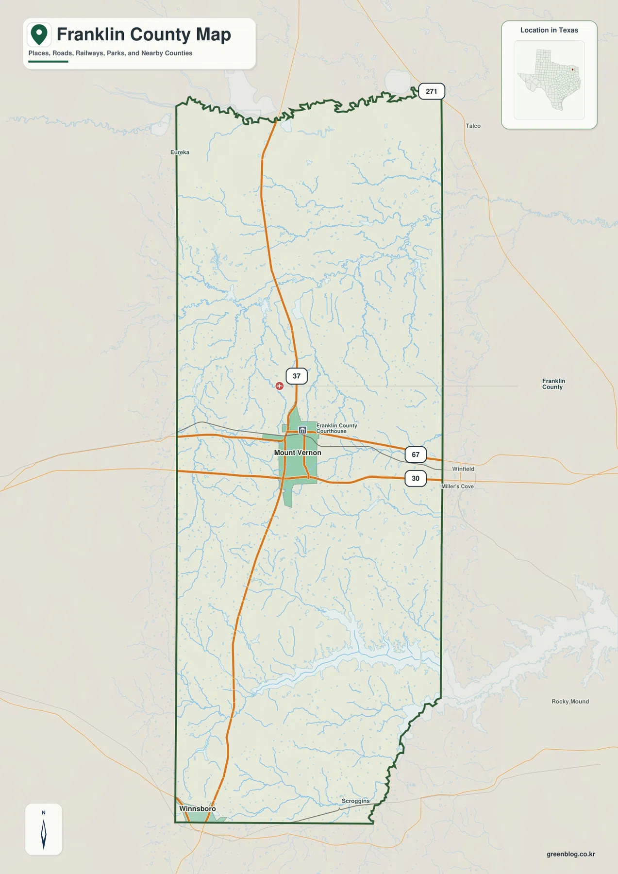
The city map highlights only Mount Vernon as a ranked major city. It is listed first in the CITY INDEX with the value 2,548 shown beside its name. Because no second ranked city appears, the graphic does not use connector lines or mileage comparisons. Its purpose is much simpler: it shows where the county’s principal highlighted settlement lies within the long north-south outline.
Mount Vernon sits somewhat north of the county’s midpoint, but the concentration of roads makes it feel central in practical map reading. Returning to the general county view shows why. Interstate 30, U.S. 67, and Route 37 all meet or pass close to the city, while the southern half contains much larger spaces between place labels. The city map therefore works best as a location anchor rather than as a population comparison among several communities.
This simple city pattern also gives a useful sequence for reading the rest of the county. Find Mount Vernon, move north to Sulphur River, then trace south toward Big Cypress Creek and Lake Cypress Springs. That sequence connects the single urban reference with the county’s two most distinctive water-and-terrain settings without relying on uncertain labels outside the county boundary.
From Sulphur River to Big Cypress Creek
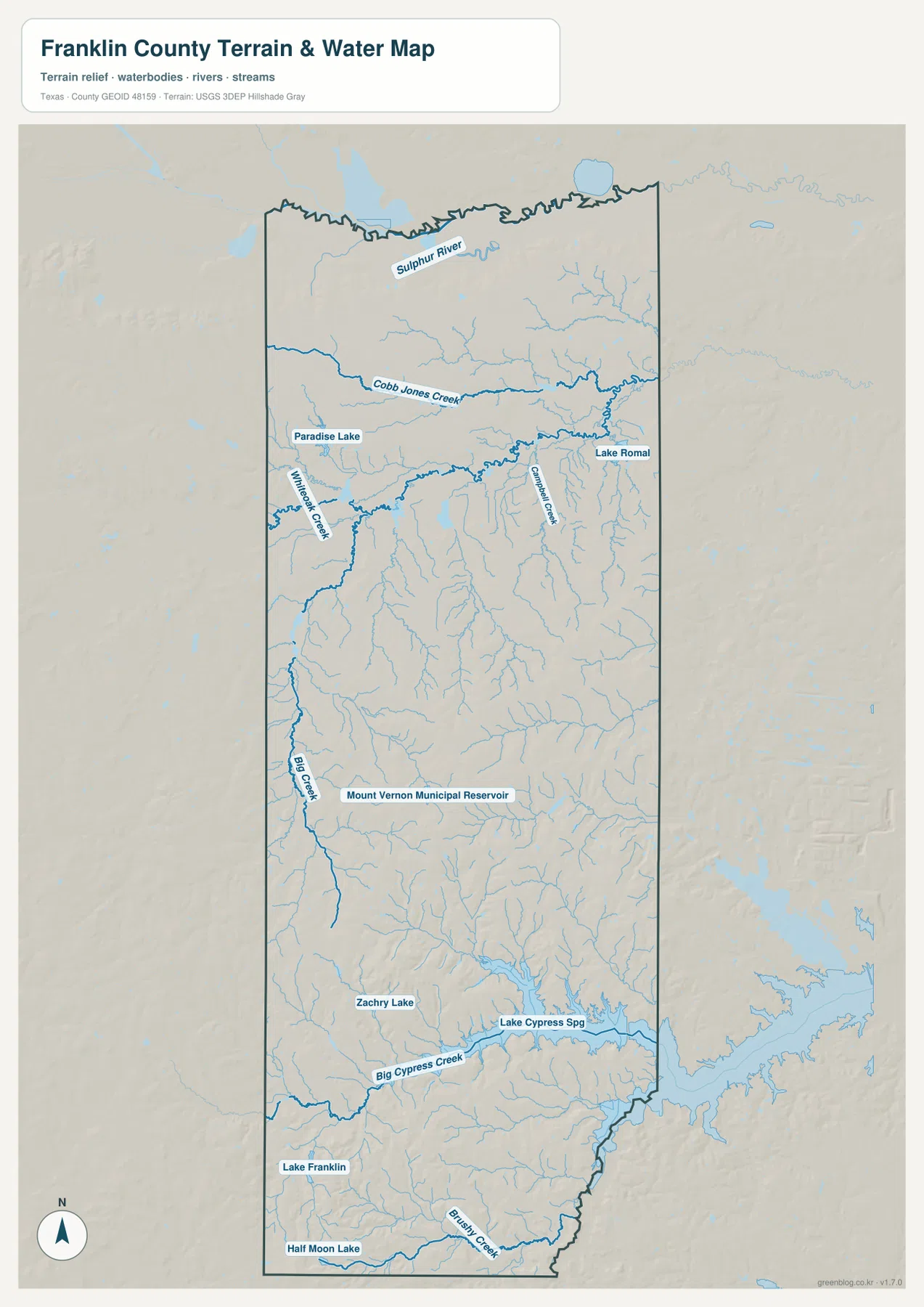
Sulphur River is the strongest water reference in northern Franklin County. It follows much of the top boundary, creating the irregular edge visible on both the general and water maps. South of the river, Cobb Jones Creek crosses a broad section of the upper county from west toward east. Winkle Creek appears on the western side, and Campbell Creek is labeled farther east, showing that the central drainage is divided among several separate channels rather than one dominant stream.
The water pattern becomes even more varied farther south. Big Creek runs along the western interior, Mount Vernon Municipal Reservoir is marked south of the central area, and Zachry Lake appears below it. Near the southern third of the county, Big Cypress Creek becomes a major east-west reference. Lake Cypress Springs occupies a prominent southeastern basin connected to that drainage, while Lake Franklin lies in the southwest and Half Moon Lake and Bushy Creek appear near the southern edge.
Smaller northern water bodies, including Paradise Lake and Lake Romal, add to the dense network. The useful way to read this map is not to memorize every label but to separate three broad settings: Sulphur River along the north, the middle band of creeks and small reservoirs, and the Big Cypress Creek–Lake Cypress Springs system in the south. The map locates water features but does not establish flood zones, legal shorelines, water depth, or whether every small channel carries water year-round.
Low Northern Drainage and Higher Central-Southern Ridges
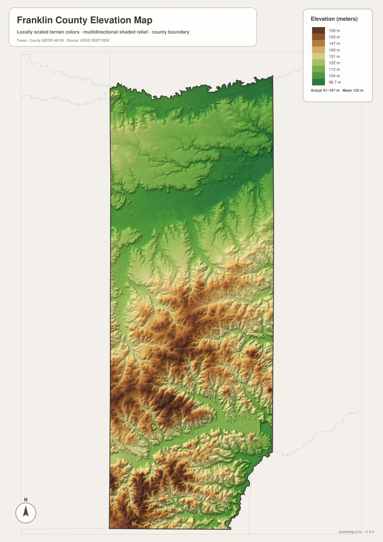
The elevation map lists an actual range of about 91 to 187 meters and a mean near 125 meters. Dark green dominates much of the northern edge around Sulphur River, showing the county’s broadest low area. The upper interior also remains comparatively low and gentle. Moving toward the middle and southern half, tan and brown ridges become more frequent and the relief grows noticeably stronger.
The higher southern terrain is not a single continuous hill. Ridges are repeatedly cut by narrow creek valleys, producing a textured pattern of alternating high and low ground. Around Big Cypress Creek and Lake Cypress Springs, green lowlands follow the water while warmer-colored ridges rise around them. Similar incisions appear through the southwest, where streams break up otherwise higher terrain.
A 91-to-187-meter range does not make Franklin County mountainous, but the locally scaled map clearly shows why the south looks rougher than the north. Comparing it with the water view is especially useful because many of the lowest green corridors line up with named creeks, reservoirs, and river valleys. The elevation surface is appropriate for county-scale comparison, not for parcel surveys, construction grades, or exact flood elevations.
What Changes South of Mount Vernon Toward Lake Cypress Springs
The clearest internal transition appears when the map is followed south from Mount Vernon. Around Interstate 30 and U.S. 67, roads form a simple horizontal framework and the terrain is comparatively subdued. Continuing south along Route 37, smaller streams become more numerous and the shaded relief grows increasingly irregular. By the Scroggins and Lake Cypress Springs area, ridges and creek valleys alternate closely and water occupies a much larger share of the visual landscape.
Traveling north from Mount Vernon produces the opposite change. Elevation generally drops toward the Sulphur River zone, and the northern edge becomes a broad lowland cut by river bends and tributaries. Mount Vernon therefore works as more than a city reference: it sits between two different physical settings. The county map establishes the route, the water map identifies the drainage features, and the elevation view explains why the northern and southern landscapes look so different.
Choosing a Map for Roads, Water, or Relief
Use the county map when the question involves Mount Vernon, Interstate 30, U.S. 67, Route 37, or the county boundary. The city index is the quickest view when you only need the position of Mount Vernon. For Sulphur River, Cobb Jones Creek, Big Cypress Creek, Lake Cypress Springs, or the smaller reservoirs and lakes, the water map provides the clearest labels. The elevation map is most useful for comparing the low northern river zone with the higher and more dissected central-southern terrain.
The WebP versions on the page are convenient for quick viewing, while the ZIP below contains the matching high-resolution A3 JPG files for printing and larger displays. The archive includes the county, city, water, and elevation maps shown here, so you can use the complete set or select only the image needed for classroom work, a presentation, local reference, or a personal map collection.
Frequently Asked Questions
What is the easiest starting point on a Franklin County map?
Mount Vernon is the most useful starting point. Interstate 30 and U.S. 67 run east-west nearby, while Route 37 crosses north-south, making the city a convenient reference for locating Sulphur River to the north and Lake Cypress Springs to the south.
Where is Lake Cypress Springs within Franklin County?
Lake Cypress Springs appears in the southeastern part of the supplied water map and is connected with the Big Cypress Creek drainage. The elevation view shows lower ground along the water, surrounded by more strongly rolling and higher terrain.
Which parts of Franklin County are lower and higher?
The northern Sulphur River area is generally lower, while higher ridges become more widespread through the central and southern parts of the county. The elevation map lists an actual range of about 91 to 187 meters and a mean near 125 meters.
Sources and Reference Data
USGS The National Map Viewer — Official map service for roads, hydrography, terrain, and other geographic layers.
USGS National Hydrography — Official reference for rivers, streams, creeks, reservoirs, and lakes.
USGS 3D Elevation Program — U.S. Geological Survey program for elevation and terrain data.
U.S. Census Bureau TIGER/Line Shapefiles — Official source for county boundaries, roads, and related base geography.
Map File Information
Download the Franklin County county map, city map, water map, and elevation map as high-resolution A3 JPG files. The ZIP contains the original map files shown on this page.
- File Type: JPG
Related Maps
- Red River County Texas map
- Titus County Texas map
- Wood County Texas map
- Morris County Texas map
- Upshur County Texas map
Green Map creates custom-edited map images using open geographic data sources such as geoBoundaries, Natural Earth, OpenStreetMap, and government open data.
These maps are edited visual materials, not raw data files, and are provided for education, documents, presentations, and graphic reference.